Bridge Statistics for Whitehall, Michigan (MI)
Condition, Traffic, Stress, Structural Evaluation, Project Costs
- National Bridge Inventory (NBI) Statistics
- 15Number of bridges
- 102ft / 31.3mTotal length
- 107,888Total average daily traffic
- 5,488Total average daily truck traffic
- National Bridge Inventory (NBI) Registered Bridges for Whitehall
- No street view available for this location
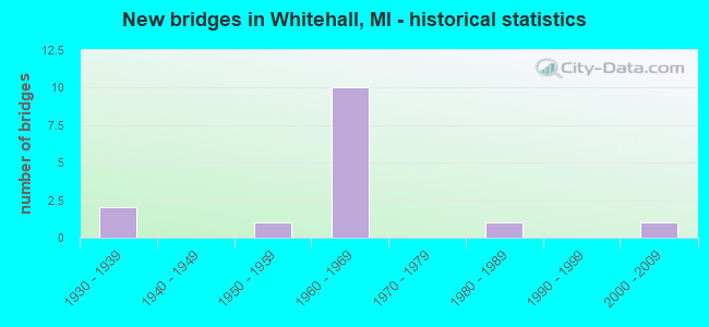
- New bridges - historical statistics
- 21930-1939
- 11950-1959
- 101960-1969
- 11980-1989
- 12000-2009

- Reconstructed bridges - Historical Statistics
- 11990-1999
- 12000-2009


- Bridge Condition - Deck
- 60.0%Good
- 40.0%Satisfactory

- Bridge Condition - Superstructure
- 10.0%Very good
- 30.0%Good
- 30.0%Satisfactory
- 30.0%Fair

- Bridge Condition - Substructure
- 10.0%Very good
- 30.0%Good
- 40.0%Satisfactory
- 20.0%Fair

- Bridge Condition - Channel
- 33.3%Very good
- 33.3%Good
- 16.7%Fair
- 16.7%Poor
Find on map >> Show street view
Structure Number: 7577, Location: 4.2 MI S OF OCEANA COL (Lat: 43.413531, Lng: -86.352019), Route carried "on" structure: Business US 31, Year Built: 1986, Status: Posted for load, Structure Length: 2.74m (8.99ft), Average Daily Traffic: 8,531 (year 2007), Truck Traffic: 3%, Average Future Daily Traffic: 17,563 (year 2018), Design Load: HS 25 or greater, Features Intersected: WHITE RIVER
Minimum Vertical Clearance: 30.48m (100.00ft), Kilometerpoint: 0.529, Lanes on structure: 2, Base Highway Network: Yes (Inventory Route: 85, Subroute: 1), Owner: State Highway Agency, Approaching Roadway Width: 11.6m (38.1ft), Material/Design: Prestressed concrete, Design/Construction: Box Beam or Girders - Multiple, Number Of Spans In Main Unit: 1, Length of Maximum Span: 27.4m (89.9ft), Curb or Sidewalk Widths: Left: 1.5m (4.9ft), Right: 1.5m (4.9ft), Curb-To-Curb Width: 15.2m (49.9ft), Out-to-Out Width: 18.9m (62.0ft)
Condition: Deck: Satisfactory, Superstructure: Fair, Substructure: Fair, Channel: Very good, Operating Rating: 36.9 metric tons, Method Used To Determine Operating Rating: Load Factor (LF) rating reported by rating factor (RF) method using MS18 loading, Inventory Rating: 22.0 metric tons, Method Used To Determine Inventory Rating: Load Factor (LF) rating reported by rating factor (RF) method using MS18 loading, Structural Evaluation: Somewhat better than minimum adequacy, Deck Geometry: Superior to present desirable criteria, Waterway Adequacy: Equal to present desirable criteria, Approach Roadway Alignment: Better than present minimum criteria, Bridge Posting: Required (Relationship of Operating Rating to Maximum Legal Load: 30.0 - 39.9% below), Designated Inspection Frequency: Every 24 months, Underwater Inspection Frequency: Every 60 months, Inspection Date: July 2021, Underwater Inspection Date: May 2020, Deck Structure Type: Concrete Cast-file-Place, Wearing Surface/Protective System: Wearing Surface: Integral Concrete, Membrane: Other, Deck Protection: Epoxy Coated Reinforcing
Find on map >> Show street view
Structure Number: 7578, Location: IN WHITEHALL (Lat: 43.409764, Lng: -86.349386), Route carried "on" structure: Business US 31, Year Built: 1933, Year Reconstructed: 2011, Status: Open, Structure Length: 0.66m (2.17ft), Average Daily Traffic: 12,781 (year 2007), Truck Traffic: 3%, Average Future Daily Traffic: 14,981 (year 2018), Design Load: Greater than HL93, Features Intersected: HART/MONT. LINEAR SP TRL
Minimum Vertical Clearance: 30.48m (100.00ft), Kilometerpoint: 2.993, Lanes on structure: 4, Base Highway Network: Yes (Inventory Route: 85, Subroute: 10), Owner: State Highway Agency, Approaching Roadway Width: 16.5m (54.1ft), Material/Design: Steel, Design/Construction: Box Beam or Girders - Single/Spread, Number Of Spans In Main Unit: 1, Length of Maximum Span: 5.9m (19.4ft), Curb or Sidewalk Widths: Left: 2.1m (6.9ft), Right: 3.0m (9.8ft), Curb-To-Curb Width: 16.5m (54.1ft), Out-to-Out Width: 22.5m (73.8ft)
Condition: Deck: Good, Superstructure: Satisfactory, Substructure: Good, Operating Rating: 64.2 metric tons, Method Used To Determine Operating Rating: Load and Resistance Factor Rating (LRFR) rating reported by rating factor(RF) method using HL-93 loadings, Inventory Rating: 49.6 metric tons, Method Used To Determine Inventory Rating: Load and Resistance Factor Rating (LRFR) rating reported by rating factor(RF) method using HL-93 loadings, Structural Evaluation: Equal to present minimum criteria, Deck Geometry: Meets minimum limits, Approach Roadway Alignment: Equal to present desirable criteria, Designated Inspection Frequency: Every 24 months, Inspection Date: July 2021, Deck Structure Type: Concrete Precast Panels, Wearing Surface/Protective System: Wearing Surface: Epoxy Overlay, Deck Protection: Epoxy Coated Reinforcing
Find on map >> Show street view
Structure Number: 7586, Location: 1.3 MI N OF S JCT US-31BR (Lat: 43.424744, Lng: -86.326994), Route carried "on" structure: US 31, Year Built: 1965, Status: Open, Structure Length: 5.15m (16.90ft), Average Daily Traffic: 9,550 (year 2020), Truck Traffic: 7%, Average Future Daily Traffic: 10,600 (year 2041), Design Load: HS 20, Features Intersected: WHITE RIVER
Minimum Vertical Clearance: 30.48m (100.00ft), Kilometerpoint: 37.876, Lanes on structure: 2, Base Highway Network: Yes (Inventory Route: 85, Subroute: 2), Owner: State Highway Agency, Approaching Roadway Width: 12.2m (40.0ft), Material/Design: Steel, Design/Construction: Stringer/Multi-beam, Number Of Spans In Main Unit: 3, Length of Maximum Span: 17.7m (58.1ft), Curb-To-Curb Width: 12.0m (39.4ft), Out-to-Out Width: 13.1m (43.0ft)
Condition: Deck: Good, Superstructure: Satisfactory, Substructure: Good, Channel: Good, Operating Rating: 59.0 metric tons, Method Used To Determine Operating Rating: Load Factor (LF) rating reported by rating factor (RF) method using MS18 loading, Inventory Rating: 35.3 metric tons, Method Used To Determine Inventory Rating: Load Factor (LF) rating reported by rating factor (RF) method using MS18 loading, Structural Evaluation: Equal to present minimum criteria, Deck Geometry: Better than present minimum criteria, Waterway Adequacy: Equal to present minimum criteria, Approach Roadway Alignment: Equal to present minimum criteria, Designated Inspection Frequency: Every 19 months, Underwater Inspection Frequency: Every 60 months, Inspection Date: December 2021, Underwater Inspection Date: May 2020, Deck Structure Type: Concrete Cast-file-Place, Wearing Surface/Protective System: Wearing Surface: Latex Concrete
Find on map >> Show street view
Structure Number: 7587, Location: 1.3 MI N OF S JCT US-31BR (Lat: 43.425097, Lng: -86.326417), Route carried "on" structure: US 31, Year Built: 1965, Status: Open, Structure Length: 5.15m (16.90ft), Average Daily Traffic: 9,550 (year 2020), Truck Traffic: 7%, Average Future Daily Traffic: 10,600 (year 2041), Design Load: HS 20, Features Intersected: WHITE RIVER
Minimum Vertical Clearance: 30.48m (100.00ft), Kilometerpoint: 37.898, Lanes on structure: 2, Base Highway Network: Yes (Inventory Route: 85, Subroute: 9), Owner: State Highway Agency, Approaching Roadway Width: 12.2m (40.0ft), Material/Design: Steel, Design/Construction: Stringer/Multi-beam, Number Of Spans In Main Unit: 3, Length of Maximum Span: 17.7m (58.1ft), Curb-To-Curb Width: 12.0m (39.4ft), Out-to-Out Width: 13.1m (43.0ft)
Condition: Deck: Good, Superstructure: Satisfactory, Substructure: Good, Channel: Good, Operating Rating: 58.6 metric tons, Method Used To Determine Operating Rating: Load Factor (LF) rating reported by rating factor (RF) method using MS18 loading, Inventory Rating: 35.0 metric tons, Method Used To Determine Inventory Rating: Load Factor (LF) rating reported by rating factor (RF) method using MS18 loading, Structural Evaluation: Equal to present minimum criteria, Deck Geometry: Better than present minimum criteria, Waterway Adequacy: Equal to present minimum criteria, Approach Roadway Alignment: Equal to present minimum criteria, Designated Inspection Frequency: Every 7 months, Underwater Inspection Frequency: Every 60 months, Inspection Date: December 2021, Underwater Inspection Date: May 2020, Deck Structure Type: Concrete Cast-file-Place, Wearing Surface/Protective System: Wearing Surface: Latex Concrete
Find on map >> Show street view
Structure Number: 7603, Location: S JCT US-31BR (Lat: 43.409364, Lng: -86.315172), Route carried "on" structure: US 31, Year Built: 1963, Status: Open, Structure Length: 3.87m (12.70ft), Average Daily Traffic: 9,754 (year 2007), Truck Traffic: 7%, Average Future Daily Traffic: 10,364 (year 2018), Design Load: HS 20, Features Intersected: US-31 BR(COLBY RD)
Minimum Vertical Clearance: 30.48m (100.00ft), Kilometerpoint: 35.861, Lanes on structure: 2, Lanes under structure: 3, Base Highway Network: Yes (Inventory Route: 85, Subroute: 2), Owner: State Highway Agency, Approaching Roadway Width: 12.2m (40.0ft), Skew: 1 degrees, Material/Design: Steel, Design/Construction: Stringer/Multi-beam, Number Of Spans In Main Unit: 3, Length of Maximum Span: 17.3m (56.8ft), Curb or Sidewalk Widths: Left: 0.1m (0.3ft), Right: 0.1m (0.3ft), Curb-To-Curb Width: 12.3m (40.4ft), Out-to-Out Width: 13.0m (42.7ft)
Condition: Deck: Satisfactory, Superstructure: Good, Substructure: Satisfactory, Operating Rating: 59.6 metric tons, Method Used To Determine Operating Rating: Load Factor (LF) rating reported by rating factor (RF) method using MS18 loading, Inventory Rating: 35.6 metric tons, Method Used To Determine Inventory Rating: Load Factor (LF) rating reported by rating factor (RF) method using MS18 loading, Structural Evaluation: Equal to present minimum criteria, Deck Geometry: Better than present minimum criteria, Underclear: High priority of corrective action, Approach Roadway Alignment: Better than present minimum criteria, Designated Inspection Frequency: Every 24 months, Inspection Date: July 2020, Deck Structure Type: Concrete Cast-file-Place, Wearing Surface/Protective System: Wearing Surface: Monolithic Concrete
Find on map >> Show street view
Structure Number: 7604, Location: S JCT US-31BR (Lat: 43.409497, Lng: -86.314383), Route carried "on" structure: US 31, Year Built: 1963, Status: Open, Structure Length: 3.90m (12.80ft), Average Daily Traffic: 9,754 (year 2007), Truck Traffic: 7%, Average Future Daily Traffic: 10,364 (year 2018), Design Load: HS 20, Features Intersected: US-31 BR COLBY RD
Minimum Vertical Clearance: 30.48m (100.00ft), Kilometerpoint: 35.854, Lanes on structure: 2, Lanes under structure: 3, Base Highway Network: Yes (Inventory Route: 85, Subroute: 9), Owner: State Highway Agency, Approaching Roadway Width: 13.7m (44.9ft), Skew: 1 degrees, Material/Design: Steel, Design/Construction: Stringer/Multi-beam, Number Of Spans In Main Unit: 3, Length of Maximum Span: 17.3m (56.8ft), Curb or Sidewalk Widths: Left: 0.1m (0.3ft), Right: 0.1m (0.3ft), Curb-To-Curb Width: 13.8m (45.3ft), Out-to-Out Width: 14.6m (47.9ft)
Condition: Deck: Good, Superstructure: Good, Substructure: Satisfactory, Operating Rating: 81.0 metric tons, Method Used To Determine Operating Rating: Load Factor (LF) rating reported by rating factor (RF) method using MS18 loading, Inventory Rating: 48.6 metric tons, Method Used To Determine Inventory Rating: Load Factor (LF) rating reported by rating factor (RF) method using MS18 loading, Structural Evaluation: Equal to present minimum criteria, Deck Geometry: Superior to present desirable criteria, Underclear: Somewhat better than minimum adequacy, Approach Roadway Alignment: Equal to present minimum criteria, Designated Inspection Frequency: Every 24 months, Inspection Date: July 2020, Deck Structure Type: Concrete Cast-file-Place, Wearing Surface/Protective System: Wearing Surface: Monolithic Concrete
Find on map >> Show street view
Structure Number: 7605, Location: 0.6 MI S OF N JCT US-31BR (Lat: 43.433850, Lng: -86.336700), Route carried "on" structure: US 31, Year Built: 1965, Status: Open, Structure Length: 3.32m (10.89ft), Average Daily Traffic: 8,086 (year 2007), Truck Traffic: 7%, Average Future Daily Traffic: 10,364 (year 2018), Design Load: HS 20, Features Intersected: WALSH RD
Minimum Vertical Clearance: 30.48m (100.00ft), Kilometerpoint: 39.110, Lanes on structure: 2, Lanes under structure: 2, Base Highway Network: Yes (Inventory Route: 85, Subroute: 2), Owner: State Highway Agency, Approaching Roadway Width: 12.2m (40.0ft), Material/Design: Steel, Design/Construction: Stringer/Multi-beam, Number Of Spans In Main Unit: 3, Length of Maximum Span: 12.5m (41.0ft), Curb or Sidewalk Widths: Left: 0.1m (0.3ft), Right: 0.1m (0.3ft), Curb-To-Curb Width: 12.3m (40.4ft), Out-to-Out Width: 13.0m (42.7ft)
Condition: Deck: Satisfactory, Superstructure: Fair, Substructure: Satisfactory, Operating Rating: 64.5 metric tons, Method Used To Determine Operating Rating: Load Factor (LF) rating reported by rating factor (RF) method using MS18 loading, Inventory Rating: 38.6 metric tons, Method Used To Determine Inventory Rating: Load Factor (LF) rating reported by rating factor (RF) method using MS18 loading, Structural Evaluation: Somewhat better than minimum adequacy, Deck Geometry: Better than present minimum criteria, Underclear: Meets minimum limits, Approach Roadway Alignment: Better than present minimum criteria, Designated Inspection Frequency: Every 24 months, Inspection Date: July 2021, Bridge Improvement Cost: $46,000, Deck Structure Type: Concrete Cast-file-Place, Wearing Surface/Protective System: Wearing Surface: Monolithic Concrete
Find on map >> Show street view
Structure Number: 7606, Location: 0.6 MI S OF N JCT US-31BR (Lat: 43.434167, Lng: -86.336028), Route carried "on" structure: US 31, Year Built: 1965, Status: Open, Structure Length: 3.38m (11.09ft), Average Daily Traffic: 8,086 (year 2007), Truck Traffic: 7%, Average Future Daily Traffic: 10,364 (year 2018), Design Load: HS 20, Features Intersected: WALSH RD
Minimum Vertical Clearance: 30.48m (100.00ft), Kilometerpoint: 39.126, Lanes on structure: 2, Lanes under structure: 2, Base Highway Network: Yes (Inventory Route: 85, Subroute: 9), Owner: State Highway Agency, Approaching Roadway Width: 12.2m (40.0ft), Material/Design: Steel, Design/Construction: Stringer/Multi-beam, Number Of Spans In Main Unit: 3, Length of Maximum Span: 12.5m (41.0ft), Curb or Sidewalk Widths: Left: 0.1m (0.3ft), Right: 0.1m (0.3ft), Curb-To-Curb Width: 12.3m (40.4ft), Out-to-Out Width: 13.0m (42.7ft)
Condition: Deck: Satisfactory, Superstructure: Fair, Substructure: Satisfactory, Operating Rating: 62.5 metric tons, Method Used To Determine Operating Rating: Load Factor (LF) rating reported by rating factor (RF) method using MS18 loading, Inventory Rating: 37.3 metric tons, Method Used To Determine Inventory Rating: Load Factor (LF) rating reported by rating factor (RF) method using MS18 loading, Structural Evaluation: Somewhat better than minimum adequacy, Deck Geometry: Better than present minimum criteria, Underclear: Meets minimum limits, Approach Roadway Alignment: Better than present minimum criteria, Designated Inspection Frequency: Every 24 months, Inspection Date: July 2021, Bridge Improvement Cost: $46,000, Deck Structure Type: Concrete Cast-file-Place, Wearing Surface/Protective System: Wearing Surface: Monolithic Concrete
Find on map >> Show street view
Structure Number: 7652, Location: 3.4 MI E OF US-31 (Lat: 43.456503, Lng: -86.284225), Route carried "on" structure: County highway 6188, Year Built: 1937, Year Reconstructed: 1995, Status: Open, Structure Length: 0.70m (2.30ft), Average Daily Traffic: 1,470 (year 2015), Truck Traffic: 7%, Average Future Daily Traffic: 2,190 (year 2035), Design Load: HS 20, Features Intersected: CARLETON CREEK, Facility Carried by Structure: FRUITVALE ROAD
Minimum Vertical Clearance: 30.48m (100.00ft), Kilometerpoint: 7.178, Lanes on structure: 2, Owner: County Highway Agency, Approaching Roadway Width: 11.0m (36.1ft), Material/Design: Wood or Timber, Design/Construction: Slab, Number Of Spans In Main Unit: 1, Length of Maximum Span: 6.4m (21.0ft), Curb-To-Curb Width: 9.1m (29.9ft), Out-to-Out Width: 9.8m (32.2ft)
Condition: Deck: Good, Superstructure: Good, Substructure: Fair, Channel: Poor, Operating Rating: 53.2 metric tons, Method Used To Determine Operating Rating: Allowable Stress (AS), Inventory Rating: 38.1 metric tons, Method Used To Determine Inventory Rating: Allowable Stress (AS), Structural Evaluation: Somewhat better than minimum adequacy, Deck Geometry: Somewhat better than minimum adequacy, Waterway Adequacy: Equal to present desirable criteria, Approach Roadway Alignment: Somewhat better than minimum adequacy, Designated Inspection Frequency: Every 24 months, Inspection Date: September 2020, Deck Structure Type: Wood or Timber, Wearing Surface/Protective System: Wearing Surface: Bituminous
Find on map >> Show street view
Structure Number: 7675, Location: 0.75 MI S OF MICHILLINDA (Lat: 43.345403, Lng: -86.356386), Route carried "on" structure: County highway , Year Built: 2009, Status: Open, Structure Length: 1.58m (5.18ft), Average Daily Traffic: 1,022 (year 2018), Truck Traffic: 2%, Average Future Daily Traffic: 1,247 (year 2038), Design Load: HS 20+Mod, Features Intersected: DUCK CREEK, Facility Carried by Structure: ORSHAL ROAD
Minimum Vertical Clearance: 30.48m (100.00ft), Kilometerpoint: 5.277, Lanes on structure: 2, Owner: County Highway Agency, Approaching Roadway Width: 9.1m (29.9ft), Material/Design: Prestressed concrete, Design/Construction: Box Beam or Girders - Multiple, Number Of Spans In Main Unit: 1, Length of Maximum Span: 15.4m (50.5ft), Curb-To-Curb Width: 8.6m (28.2ft), Out-to-Out Width: 9.5m (31.2ft)
Condition: Deck: Good, Superstructure: Very good, Substructure: Very good, Channel: Very good, Operating Rating: 81.0 metric tons, Method Used To Determine Operating Rating: Load Factor (LF), Inventory Rating: 48.6 metric tons, Method Used To Determine Inventory Rating: Load Factor (LF), Structural Evaluation: Equal to present desirable criteria, Deck Geometry: Somewhat better than minimum adequacy, Waterway Adequacy: Equal to present minimum criteria, Approach Roadway Alignment: Equal to present minimum criteria, Designated Inspection Frequency: Every 24 months, Inspection Date: September 2020, Deck Structure Type: Concrete Cast-file-Place, Wearing Surface/Protective System: Wearing Surface: Epoxy Overlay, Deck Protection: Epoxy Coated Reinforcing
Find on map >> Show street view
Structure Number: 13349, Location: FRUITLAND TWP SEC 15/16 (Lat: 43.348136, Lng: -86.336425), Route carried "on" structure: County highway , Year Built: 1955, Status: Posted for load, Structure Length: 0.84m (2.76ft), Average Daily Traffic: 400 (year 2015), Truck Traffic: 16%, Average Future Daily Traffic: 161 (year 2026), Features Intersected: SCHOLES CREEK, Facility Carried by Structure: SIMONELLI ROAD
Minimum Vertical Clearance: 30.48m (100.00ft), Kilometerpoint: 5.631, Lanes on structure: 2, Owner: County Highway Agency, Approaching Roadway Width: 6.7m (22.0ft), Material/Design: Steel, Design/Construction: Culvert, Number Of Spans In Main Unit: 3, Length of Maximum Span: 2.3m (7.5ft), Curb-To-Curb Width: 6.7m (22.0ft), Out-to-Out Width: 6.7m (22.0ft)
Condition: Channel: Fair, Culverts: Critical, Operating Rating: 12.0 metric tons, Method Used To Determine Operating Rating: Load Factor (LF) rating reported by rating factor (RF) method using MS18 loading, Inventory Rating: 7.1 metric tons, Method Used To Determine Inventory Rating: Load Factor (LF) rating reported by rating factor (RF) method using MS18 loading, Structural Evaluation: High priority of replacement, Deck Geometry: Meets minimum limits, Waterway Adequacy: Somewhat better than minimum adequacy, Approach Roadway Alignment: Better than present minimum criteria, Bridge Posting: Required (Relationship of Operating Rating to Maximum Legal Load: > 39.9% below), Designated Inspection Frequency: Every 6 months, Inspection Date: September 2021, Wearing Surface/Protective System: Wearing Surface: Bituminous
Find on map >> Show street view
Structure Number: 7603, Location: S JCT US-31BR (Lat: 43.409364, Lng: -86.315172), Route carried "under" structure: Business US 31, Year Built: 1963, Structure Length: 0. m, Average Daily Traffic: 13,365 (year 2007), Truck Traffic: 3%, Features Intersected: US-31 BR(COLBY RD)
Minimum Vertical Clearance: 4.50m (14.76ft), Kilometerpoint: 0.216, Lanes on structure: 2, Lanes under structure: 3, Material/Design: Steel, Design/Construction: Stringer/Multi-beam, Length of Maximum Span: 17.3m (56.8ft)
Find on map >> Show street view
Structure Number: 7604, Location: S JCT US-31BR (Lat: 43.409497, Lng: -86.314383), Route carried "under" structure: Business US 31, Year Built: 1963, Structure Length: 0. m, Average Daily Traffic: 13,365 (year 2007), Truck Traffic: 3%, Features Intersected: US-31 BR COLBY RD
Minimum Vertical Clearance: 4.42m (14.50ft), Kilometerpoint: 0.150, Lanes on structure: 2, Lanes under structure: 3, Material/Design: Steel, Design/Construction: Stringer/Multi-beam, Length of Maximum Span: 17.3m (56.8ft)
Find on map >> Show street view
Structure Number: 7605, Location: 0.6 MI S OF N JCT US-31BR (Lat: 43.433850, Lng: -86.336700), Route carried "under" structure: County highway , Year Built: 1965, Structure Length: 0. m, Average Daily Traffic: 1,087 (year 1997), Features Intersected: WALSH RD, Facility Carried by Structure: US-31 SB
Minimum Vertical Clearance: 4.62m (15.16ft), Kilometerpoint: 1.421, Lanes on structure: 2, Lanes under structure: 2, Material/Design: Steel, Design/Construction: Stringer/Multi-beam, Length of Maximum Span: 12.5m (41.0ft)
Find on map >> Show street view
Structure Number: 7606, Location: 0.6 MI S OF N JCT US-31BR (Lat: 43.434167, Lng: -86.336028), Route carried "under" structure: County highway , Year Built: 1965, Structure Length: 0. m, Average Daily Traffic: 1,087 (year 1997), Truck Traffic: 3%, Features Intersected: WALSH RD, Facility Carried by Structure: US-31 NB
Minimum Vertical Clearance: 4.55m (14.93ft), Kilometerpoint: 1.485, Lanes on structure: 2, Lanes under structure: 2, Material/Design: Steel, Design/Construction: Stringer/Multi-beam, Length of Maximum Span: 12.5m (41.0ft)