Bridge Statistics for White Springs, Florida (FL)
Condition, Traffic, Stress, Structural Evaluation, Project Costs
- National Bridge Inventory (NBI) Statistics
- 19Number of bridges
- 233ft / 71.2mTotal length
- $71,000Total costs
- 191,933Total average daily traffic
- 59,454Total average daily truck traffic
- National Bridge Inventory (NBI) Registered Bridges for White Springs
- No street view available for this location
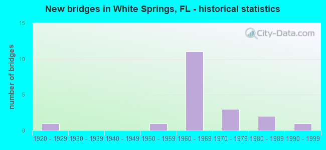
- New bridges - historical statistics
- 11920-1929
- 11950-1959
- 111960-1969
- 31970-1979
- 21980-1989
- 11990-1999

- Reconstructed bridges - Historical Statistics
- 11940-1949
- 01950-1959
- 01960-1969
- 11970-1979
- 21980-1989
- 11990-1999


- Bridge Condition - Deck
- 58.3%Good
- 33.3%Satisfactory
- 8.3%Fair

- Bridge Condition - Superstructure
- 66.7%Good
- 25.0%Satisfactory
- 8.3%Fair

- Bridge Condition - Substructure
- 8.3%Very good
- 58.3%Good
- 25.0%Satisfactory
- 8.3%Fair

- Bridge Condition - Channel
- 36.4%Good
- 63.6%Satisfactory
Find on map >> Show street view
Structure Number: 29003, Location: 0.1 MI. W. OF US-41 (Lat: 30.328156, Lng: -82.759758), Route carried "on" structure: State highway 136, Year Built: 1954, Status: Open, Structure Length: 9.06m (29.72ft), Average Daily Traffic: 2,200 (year 2020), Truck Traffic: 8%, Average Future Daily Traffic: 3,817 (year 2042), Design Load: H 15, Features Intersected: SUWANNEE RIVER
Minimum Vertical Clearance: 30+ m (98+ ft), Kilometerpoint: 3.520, Lanes on structure: 2, Base Highway Network: Yes, Owner: State Highway Agency, Approaching Roadway Width: 9.4m (30.8ft), Navigation Control: Yes ( Vertical Clearance: 0.3m (1.0ft), Horizontal Clearance: 0.3m (1.0ft)), Material/Design: Steel continuous, Design/Construction: Girder and Floorbeam System, Number Of Spans In Main Unit: 3, Length of Maximum Span: 38.4m (126.0ft), Curb or Sidewalk Widths: Left: 1.1m (3.6ft), Right: 1.2m (3.9ft), Curb-To-Curb Width: 7.3m (24.0ft), Out-to-Out Width: 10.4m (34.1ft)
Condition: Deck: Satisfactory, Superstructure: Good, Substructure: Fair, Channel: Good, Operating Rating: 32.9 metric tons, Method Used To Determine Operating Rating: Load Factor (LF), Inventory Rating: 19.6 metric tons, Method Used To Determine Inventory Rating: Load Factor (LF), Structural Evaluation: Somewhat better than minimum adequacy, Deck Geometry: High priority of replacement, Waterway Adequacy: Equal to present desirable criteria, Approach Roadway Alignment: Equal to present minimum criteria, Length Of Structure Improvement: 9.06m (29.72ft), Designated Inspection Frequency: Every 24 months, Critical Feature Inspection Frequency: Every 24 months, Underwater Inspection Frequency: Every 23 months, Inspection Date: September 2021, Critical Feature Inspection Date: September 2021, Underwater Inspection Date: September 2021, Bridge Improvement Cost: $47,000, Roadway Improvement Cost: $5,000, Total Project Cost: $71,000, Deck Structure Type: Concrete Cast-file-Place
Find on map >> Show street view
Structure Number: 290036, Location: 1.5 MI.W.OF SUWANNEE RIV. (Lat: 30.320097, Lng: -82.783469), Route carried "on" structure: State highway 136, Year Built: 1971, Status: Open, Structure Length: 0.64m (2.10ft), Average Daily Traffic: 2,200 (year 2020), Truck Traffic: 8%, Average Future Daily Traffic: 3,817 (year 2042), Design Load: HS 20+Mod, Features Intersected: TIGER BRANCH
Minimum Vertical Clearance: 30+ m (98+ ft), Kilometerpoint: 1.086, Lanes on structure: 2, Base Highway Network: Yes, Owner: State Highway Agency, Approaching Roadway Width: 9.8m (32.2ft), Skew: 2 degrees, Material/Design: Concrete, Design/Construction: Culvert, Number Of Spans In Main Unit: 2, Length of Maximum Span: 3.0m (9.8ft)
Condition: Channel: Satisfactory, Culverts: Satisfactory, Inventory Rating: 89.4 metric tons, Method Used To Determine Inventory Rating: Load Factor (LF), Structural Evaluation: Equal to present minimum criteria, Waterway Adequacy: Equal to present desirable criteria, Approach Roadway Alignment: Equal to present desirable criteria, Designated Inspection Frequency: Every 24 months, Inspection Date: December 2021
Find on map >> Show street view
Structure Number: 290049, Location: 0.7 MI EAST OF US 41 (Lat: 30.315694, Lng: -82.702972), Route carried "on" structure: County highway 246, Year Built: 1968, Status: Posted for load-capacity, Structure Length: 3.66m (12.01ft), Average Daily Traffic: 300 (year 2021), Truck Traffic: 3%, Average Future Daily Traffic: 521 (year 2042), Features Intersected: FALLING CREEK
Minimum Vertical Clearance: 30+ m (98+ ft), Kilometerpoint: 1.165, Lanes on structure: 2, Owner: County Highway Agency, Approaching Roadway Width: 6.4m (21.0ft), Material/Design: Prestressed concrete, Design/Construction: Slab, Number Of Spans In Main Unit: 4, Length of Maximum Span: 9.1m (29.9ft), Curb or Sidewalk Widths: Left: 0.5m (1.6ft), Right: 0.5m (1.6ft), Curb-To-Curb Width: 7.3m (24.0ft), Out-to-Out Width: 8.9m (29.2ft)
Condition: Deck: Fair, Superstructure: Fair, Substructure: Satisfactory, Channel: Satisfactory, Operating Rating: 34.3 metric tons, Method Used To Determine Operating Rating: Load and Resistance Factor (LRFR), Inventory Rating: 21.9 metric tons, Method Used To Determine Inventory Rating: Load and Resistance Factor (LRFR), Structural Evaluation: Somewhat better than minimum adequacy, Deck Geometry: Somewhat better than minimum adequacy, Waterway Adequacy: Equal to present desirable criteria, Approach Roadway Alignment: Equal to present desirable criteria, Designated Inspection Frequency: Every 24 months, Underwater Inspection Frequency: Every 24 months, Inspection Date: November 2021, Underwater Inspection Date: November 2021, Deck Structure Type: Concrete Precast Panels, Wearing Surface/Protective System: Wearing Surface: Bituminous
Find on map >> Show street view
Structure Number: 290065, Location: I-10 WB OVER I-75 (Lat: 30.267739, Lng: -82.754925), Route carried "on" structure: Interstate 10, Year Built: 1962, Year Reconstructed: 1989, Status: Open, Structure Length: 8.96m (29.40ft), Average Daily Traffic: 12,250 (year 2020), Truck Traffic: 30%, Average Future Daily Traffic: 21,254 (year 2042), Design Load: HS 20+Mod, Features Intersected: I-75 (SR-93)
Minimum Vertical Clearance: 30+ m (98+ ft), Kilometerpoint: 3.899, Lanes on structure: 3, Lanes under structure: 7, Base Highway Network: Yes, Owner: State Highway Agency, Approaching Roadway Width: 16.7m (54.8ft), Skew: 4 degrees, Material/Design: Prestressed concrete, Design/Construction: Stringer/Multi-beam, Number Of Spans In Main Unit: 4, Length of Maximum Span: 31.1m (102.0ft), Curb-To-Curb Width: 15.8m (51.8ft), Out-to-Out Width: 16.7m (54.8ft)
Condition: Deck: Good, Superstructure: Satisfactory, Substructure: Good, Operating Rating: 73.0 metric tons, Method Used To Determine Operating Rating: Load Factor (LF), Inventory Rating: 43.7 metric tons, Method Used To Determine Inventory Rating: Load Factor (LF), Structural Evaluation: Equal to present minimum criteria, Deck Geometry: Somewhat better than minimum adequacy, Underclear: High priority of corrective action, Approach Roadway Alignment: Equal to present desirable criteria, Designated Inspection Frequency: Every 24 months, Inspection Date: November 2021, Deck Structure Type: Concrete Cast-file-Place
Find on map >> Show street view
Structure Number: 290066, Location: SPRINGVILLE RD/I-75 (Lat: 30.290903, Lng: -82.776750), Route carried "on" structure: County highway , Year Built: 1962, Status: Open, Structure Length: 6.46m (21.19ft), Average Daily Traffic: 450 (year 2020), Truck Traffic: 2%, Average Future Daily Traffic: 781 (year 2042), Design Load: H 20, Features Intersected: I-75 (SR-93), Facility Carried by Structure: SPRINGVILLE RD
Minimum Vertical Clearance: 30+ m (98+ ft), Kilometerpoint: 0.945, Lanes on structure: 2, Lanes under structure: 6, Owner: State Highway Agency, Approaching Roadway Width: 6.4m (21.0ft), Material/Design: Prestressed concrete, Design/Construction: Stringer/Multi-beam, Number Of Spans In Main Unit: 4, Length of Maximum Span: 20.7m (67.9ft), Curb or Sidewalk Widths: Left: 0.6m (2.0ft), Right: 0.6m (2.0ft), Curb-To-Curb Width: 7.3m (24.0ft), Out-to-Out Width: 9.2m (30.2ft)
Condition: Deck: Good, Superstructure: Good, Substructure: Good, Operating Rating: 53.4 metric tons, Method Used To Determine Operating Rating: Load Factor (LF), Inventory Rating: 44.5 metric tons, Method Used To Determine Inventory Rating: Load Factor (LF), Structural Evaluation: Better than present minimum criteria, Deck Geometry: Meets minimum limits, Underclear: Meets minimum limits, Approach Roadway Alignment: Equal to present desirable criteria, Designated Inspection Frequency: Every 24 months, Inspection Date: January 2022, Deck Structure Type: Concrete Cast-file-Place
Find on map >> Show street view
Structure Number: 290069, Location: I-75 SB RAMP TO I-10 EB (Lat: 30.268183, Lng: -82.757850), Route carried "on" structure: Ramp Interstate 75, Year Built: 1962, Year Reconstructed: 1992, Status: Open, Structure Length: 5.24m (17.19ft), Average Daily Traffic: 5,900 (year 2020), Truck Traffic: 33%, Average Future Daily Traffic: 10,236 (year 2042), Features Intersected: I-10 WB (SR-8)
Minimum Vertical Clearance: 30+ m (98+ ft), Kilometerpoint: 0.418, Lanes on structure: 1, Lanes under structure: 3, Owner: State Highway Agency, Approaching Roadway Width: 9.9m (32.5ft), Skew: 4 degrees, Material/Design: Prestressed concrete, Design/Construction: Stringer/Multi-beam, Number Of Spans In Main Unit: 3, Length of Maximum Span: 21.9m (71.9ft), Curb-To-Curb Width: 9.2m (30.2ft), Out-to-Out Width: 9.9m (32.5ft)
Condition: Deck: Good, Superstructure: Good, Substructure: Very good, Operating Rating: 63.3 metric tons, Method Used To Determine Operating Rating: Load Factor (LF), Inventory Rating: 38.0 metric tons, Method Used To Determine Inventory Rating: Load Factor (LF), Structural Evaluation: Better than present minimum criteria, Deck Geometry: Superior to present desirable criteria, Underclear: Meets minimum limits, Approach Roadway Alignment: Somewhat better than minimum adequacy, Designated Inspection Frequency: Every 24 months, Inspection Date: January 2022, Deck Structure Type: Concrete Cast-file-Place
Find on map >> Show street view
Structure Number: 290083, Location: US-41 AT WHITE SPRINGS (Lat: 30.325822, Lng: -82.738508), Route carried "on" structure: US 41, Year Built: 1980, Status: Open, Structure Length: 12.50m (41.01ft), Average Daily Traffic: 3,000 (year 2020), Truck Traffic: 10%, Average Future Daily Traffic: 5,205 (year 2042), Design Load: HS 20, Features Intersected: SUWANNEE RIVER
Minimum Vertical Clearance: 30+ m (98+ ft), Kilometerpoint: 18.350, Lanes on structure: 2, Base Highway Network: Yes, Owner: State Highway Agency, Approaching Roadway Width: 9.8m (32.2ft), Navigation Control: Yes ( Vertical Clearance: 9.7m (31.8ft), Horizontal Clearance: 27.3m (89.6ft)), Material/Design: Prestressed concrete, Design/Construction: Stringer/Multi-beam, Number Of Spans In Main Unit: 6, Length of Maximum Span: 30.5m (100.1ft), Curb-To-Curb Width: 13.4m (44.0ft), Out-to-Out Width: 14.2m (46.6ft)
Condition: Deck: Good, Superstructure: Good, Substructure: Good, Channel: Satisfactory, Operating Rating: 48.0 metric tons, Method Used To Determine Operating Rating: Load Factor (LF), Inventory Rating: 35.6 metric tons, Method Used To Determine Inventory Rating: Load Factor (LF), Structural Evaluation: Better than present minimum criteria, Deck Geometry: Better than present minimum criteria, Waterway Adequacy: Equal to present desirable criteria, Approach Roadway Alignment: Equal to present desirable criteria, Designated Inspection Frequency: Every 24 months, Underwater Inspection Frequency: Every 24 months, Inspection Date: April 2021, Underwater Inspection Date: April 2021, Deck Structure Type: Concrete Cast-file-Place
Find on map >> Show street view
Structure Number: 29094, Location: 0.1 MI.S.OF SUWANNEE CO. (Lat: 30.305000, Lng: -82.793889), Route carried "on" structure: Interstate 75, Year Built: 1962, Year Reconstructed: 1998, Status: Open, Structure Length: 0.96m (3.15ft), Average Daily Traffic: 37,000 (year 2020), Truck Traffic: 33%, Average Future Daily Traffic: 64,195 (year 2042), Design Load: HS 20+Mod, Features Intersected: TIGER BRANCH
Minimum Vertical Clearance: 30+ m (98+ ft), Kilometerpoint: 48.834, Lanes on structure: 6, Base Highway Network: Yes, Owner: State Highway Agency, Approaching Roadway Width: 18.6m (61.0ft), Material/Design: Concrete, Design/Construction: Culvert, Number Of Spans In Main Unit: 3, Length of Maximum Span: 3.0m (9.8ft)
Condition: Channel: Good, Culverts: Satisfactory, Inventory Rating: 56.4 metric tons, Method Used To Determine Inventory Rating: Load Factor (LF), Structural Evaluation: Equal to present minimum criteria, Waterway Adequacy: Equal to present desirable criteria, Approach Roadway Alignment: Equal to present desirable criteria, Designated Inspection Frequency: Every 24 months, Inspection Date: March 2021
Find on map >> Show street view
Structure Number: 320001, Location: 3 MI. N. OF WHITE SPRINGS (Lat: 30.370703, Lng: -82.800019), Route carried "on" structure: US 41, Year Built: 1927, Year Reconstructed: 1947, Status: Open, Structure Length: 3.23m (10.60ft), Average Daily Traffic: 1,600 (year 2020), Truck Traffic: 10%, Average Future Daily Traffic: 2,776 (year 2042), Design Load: H 15, Features Intersected: SWIFT CREEK
Minimum Vertical Clearance: 30+ m (98+ ft), Kilometerpoint: 8.385, Lanes on structure: 2, Base Highway Network: Yes, Owner: State Highway Agency, Approaching Roadway Width: 9.9m (32.5ft), Material/Design: Concrete, Design/Construction: Tee Beam, Number Of Spans In Main Unit: 4, Length of Maximum Span: 7.9m (25.9ft), Curb-To-Curb Width: 8.5m (27.9ft), Out-to-Out Width: 9.8m (32.2ft)
Condition: Deck: Satisfactory, Superstructure: Good, Substructure: Satisfactory, Channel: Good, Operating Rating: 57.3 metric tons, Method Used To Determine Operating Rating: Load Factor (LF), Inventory Rating: 34.3 metric tons, Method Used To Determine Inventory Rating: Load Factor (LF), Structural Evaluation: Equal to present minimum criteria, Deck Geometry: Somewhat better than minimum adequacy, Waterway Adequacy: Equal to present desirable criteria, Approach Roadway Alignment: Equal to present desirable criteria, Designated Inspection Frequency: Every 24 months, Inspection Date: September 2021, Deck Structure Type: Concrete Cast-file-Place, Wearing Surface/Protective System: Wearing Surface: Bituminous
Find on map >> Show street view
Structure Number: 320049, Location: 3.75 MI WEST OF US 41 (Lat: 30.350833, Lng: -82.817778), Route carried "on" structure: County highway 25A, Year Built: 1978, Status: Posted for load, Structure Length: 6.10m (20.01ft), Average Daily Traffic: 550 (year 2021), Truck Traffic: 26%, Average Future Daily Traffic: 955 (year 2042), Design Load: HS 20, Features Intersected: SWIFT CREEK
Minimum Vertical Clearance: 30+ m (98+ ft), Kilometerpoint: 5.340, Lanes on structure: 2, Owner: County Highway Agency, Approaching Roadway Width: 6.4m (21.0ft), Skew: 1 degrees, Material/Design: Concrete continuous, Design/Construction: Slab, Number Of Spans In Main Unit: 6, Length of Maximum Span: 10.8m (35.4ft), Curb-To-Curb Width: 9.8m (32.2ft), Out-to-Out Width: 10.7m (35.1ft)
Condition: Deck: Good, Superstructure: Good, Substructure: Good, Channel: Satisfactory, Operating Rating: 24.5 metric tons, Method Used To Determine Operating Rating: Load and Resistance Factor (LRFR), Inventory Rating: 19.0 metric tons, Method Used To Determine Inventory Rating: Load and Resistance Factor (LRFR), Structural Evaluation: Somewhat better than minimum adequacy, Deck Geometry: Equal to present minimum criteria, Waterway Adequacy: Equal to present desirable criteria, Approach Roadway Alignment: Equal to present minimum criteria, Bridge Posting: Required (Relationship of Operating Rating to Maximum Legal Load: 20.0 - 29.9% below), Designated Inspection Frequency: Every 24 months, Other Special Inspection Frequency: Every 12 months, Inspection Date: December 2021, Other Special Inspection Date: December 2021, Deck Structure Type: Concrete Cast-file-Place
Find on map >> Show street view
Structure Number: 32005, Location: 1.8 MI W OF US 41 (Lat: 30.343056, Lng: -82.789722), Route carried "on" structure: County highway 25A, Year Built: 1978, Status: Open, Structure Length: 3.23m (10.60ft), Average Daily Traffic: 550 (year 2021), Truck Traffic: 26%, Average Future Daily Traffic: 955 (year 2042), Design Load: HS 20, Features Intersected: SAL MARIE BRANCH
Minimum Vertical Clearance: 30+ m (98+ ft), Kilometerpoint: 8.341, Lanes on structure: 2, Owner: County Highway Agency, Approaching Roadway Width: 6.2m (20.3ft), Skew: 3 degrees, Material/Design: Concrete continuous, Design/Construction: Slab, Number Of Spans In Main Unit: 4, Length of Maximum Span: 9.0m (29.5ft), Curb-To-Curb Width: 9.8m (32.2ft), Out-to-Out Width: 10.6m (34.8ft)
Condition: Deck: Good, Superstructure: Good, Substructure: Good, Channel: Good, Operating Rating: 42.8 metric tons, Method Used To Determine Operating Rating: Load and Resistance Factor (LRFR), Inventory Rating: 33.0 metric tons, Method Used To Determine Inventory Rating: Load and Resistance Factor (LRFR), Structural Evaluation: Better than present minimum criteria, Deck Geometry: Equal to present minimum criteria, Waterway Adequacy: Equal to present desirable criteria, Approach Roadway Alignment: Equal to present desirable criteria, Designated Inspection Frequency: Every 24 months, Inspection Date: December 2021, Deck Structure Type: Concrete Cast-file-Place
Find on map >> Show street view
Structure Number: 324222, Location: 100FT W OF SE 154TH AVE (Lat: 30.363389, Lng: -82.799861), Route carried "on" structure: County highway , Year Built: 1963, Year Reconstructed: 1984, Status: Posted for load, Structure Length: 1.21m (3.97ft), Average Daily Traffic: 31 (year 2021), Average Future Daily Traffic: 54 (year 2042), Features Intersected: SWIFT CREEK, Facility Carried by Structure: SE 95TH STREET
Minimum Vertical Clearance: 30+ m (98+ ft), Kilometerpoint: 0.000, Lanes on structure: 1, Owner: County Highway Agency, Approaching Roadway Width: 4.5m (14.8ft), Material/Design: Wood or Timber, Design/Construction: Stringer/Multi-beam, Number Of Spans In Main Unit: 3, Length of Maximum Span: 4.6m (15.1ft), Curb or Sidewalk Widths: Left: 0.2m (0.7ft), Right: 0.2m (0.7ft), Curb-To-Curb Width: 4.3m (14.1ft), Out-to-Out Width: 4.3m (14.1ft)
Condition: Deck: Satisfactory, Superstructure: Satisfactory, Substructure: Satisfactory, Channel: Satisfactory, Operating Rating: 11.1 metric tons, Method Used To Determine Operating Rating: Allowable Stress (AS), Inventory Rating: 8.3 metric tons, Method Used To Determine Inventory Rating: Allowable Stress (AS), Structural Evaluation: High priority of corrective action, Deck Geometry: Equal to present minimum criteria, Waterway Adequacy: Somewhat better than minimum adequacy, Approach Roadway Alignment: Equal to present minimum criteria, Bridge Posting: Required (Relationship of Operating Rating to Maximum Legal Load: > 39.9% below), Designated Inspection Frequency: Every 24 months, Other Special Inspection Frequency: Every 12 months, Inspection Date: December 2021, Other Special Inspection Date: December 2021, Deck Structure Type: Wood or Timber, Wearing Surface/Protective System: Wearing Surface: Wood or Timber
Find on map >> Show street view
Structure Number: 324305, Location: 0.8 MI NORTH OF CR 137 (Lat: 30.373611, Lng: -82.799167), Route carried "on" structure: County highway , Year Built: 1996, Status: Posted for load, Structure Length: 2.26m (7.41ft), Average Daily Traffic: 101 (year 2021), Truck Traffic: 2%, Average Future Daily Traffic: 175 (year 2042), Features Intersected: SWIFT CREEK, Facility Carried by Structure: SE 142ND BLVD
Minimum Vertical Clearance: 30+ m (98+ ft), Kilometerpoint: 0.000, Lanes on structure: 1, Owner: County Highway Agency, Approaching Roadway Width: 5.2m (17.1ft), Material/Design: Wood or Timber, Design/Construction: Stringer/Multi-beam, Number Of Spans In Main Unit: 5, Length of Maximum Span: 4.8m (15.7ft), Curb or Sidewalk Widths: Left: 0.2m (0.7ft), Right: 0.2m (0.7ft), Curb-To-Curb Width: 4.3m (14.1ft), Out-to-Out Width: 4.3m (14.1ft)
Condition: Deck: Satisfactory, Superstructure: Satisfactory, Substructure: Good, Channel: Satisfactory, Operating Rating: 10.9 metric tons, Method Used To Determine Operating Rating: Load and Resistance Factor (LRFR), Inventory Rating: 8.4 metric tons, Method Used To Determine Inventory Rating: Load and Resistance Factor (LRFR), Structural Evaluation: High priority of corrective action, Deck Geometry: High priority of replacement, Waterway Adequacy: Better than present minimum criteria, Approach Roadway Alignment: Better than present minimum criteria, Bridge Posting: Required (Relationship of Operating Rating to Maximum Legal Load: > 39.9% below), Designated Inspection Frequency: Every 24 months, Other Special Inspection Frequency: Every 12 months, Inspection Date: December 2021, Other Special Inspection Date: December 2021, Deck Structure Type: Wood or Timber, Wearing Surface/Protective System: Wearing Surface: Wood or Timber
Find on map >> Show street view
Structure Number: 370001, Location: 5.0 MI. N. OF I-10 (Lat: 30.317319, Lng: -82.807033), Route carried "on" structure: State highway 136, Year Built: 1962, Status: Open, Structure Length: 6.89m (22.60ft), Average Daily Traffic: 2,400 (year 2020), Truck Traffic: 8%, Average Future Daily Traffic: 4,164 (year 2042), Design Load: HS 20+Mod, Features Intersected: I-75 (SR-93)
Minimum Vertical Clearance: 30+ m (98+ ft), Kilometerpoint: 0.352, Lanes on structure: 2, Lanes under structure: 8, Base Highway Network: Yes, Owner: State Highway Agency, Approaching Roadway Width: 9.7m (31.8ft), Material/Design: Prestressed concrete, Design/Construction: Stringer/Multi-beam, Number Of Spans In Main Unit: 4, Length of Maximum Span: 24.1m (79.1ft), Curb-To-Curb Width: 8.4m (27.6ft), Out-to-Out Width: 10.4m (34.1ft)
Condition: Deck: Good, Superstructure: Good, Substructure: Good, Operating Rating: 57.1 metric tons, Method Used To Determine Operating Rating: Load Factor (LF), Inventory Rating: 34.2 metric tons, Method Used To Determine Inventory Rating: Load Factor (LF), Structural Evaluation: Better than present minimum criteria, Deck Geometry: High priority of corrective action, Underclear: Somewhat better than minimum adequacy, Approach Roadway Alignment: Better than present minimum criteria, Designated Inspection Frequency: Every 24 months, Inspection Date: September 2020, Deck Structure Type: Concrete Cast-file-Place
Find on map >> Show street view
Structure Number: 374017, Location: 1.1 MI EAST OF CR 137 (Lat: 30.290861, Lng: -82.803611), Route carried "on" structure: County highway , Year Built: 1988, Status: Open, Structure Length: 0.78m (2.56ft), Average Daily Traffic: 151 (year 2020), Truck Traffic: 5%, Average Future Daily Traffic: 262 (year 2042), Features Intersected: TIGER BRANCH, Facility Carried by Structure: ADAMS ROAD
Minimum Vertical Clearance: 30+ m (98+ ft), Kilometerpoint: 5.153, Lanes on structure: 2, Owner: County Highway Agency, Approaching Roadway Width: 7.9m (25.9ft), Skew: 1 degrees, Material/Design: Steel, Design/Construction: Culvert, Number Of Spans In Main Unit: 3, Length of Maximum Span: 2.5m (8.2ft)
Condition: Channel: Satisfactory, Culverts: Satisfactory, Structural Evaluation: Equal to present minimum criteria, Waterway Adequacy: Better than present minimum criteria, Approach Roadway Alignment: Somewhat better than minimum adequacy, Designated Inspection Frequency: Every 24 months, Inspection Date: March 2020
Find on map >> Show street view
Structure Number: 290065, Location: I-10 WB OVER I-75 (Lat: 30.267739, Lng: -82.754925), Route carried "under" structure: Interstate 75, Year Built: 1962, Structure Length: 0. m, Average Daily Traffic: 37,000 (year 2020), Truck Traffic: 33%, Features Intersected: I-75 (SR-93), Facility Carried by Structure: I-10 WB (SR-8)
Minimum Vertical Clearance: 5.39m (17.68ft), Kilometerpoint: 43.280, Lanes on structure: 3, Lanes under structure: 7, Material/Design: Prestressed concrete, Design/Construction: Stringer/Multi-beam, Length of Maximum Span: 31.1m (102.0ft)
Find on map >> Show street view
Structure Number: 290066, Location: SPRINGVILLE RD/I-75 (Lat: 30.290903, Lng: -82.776750), Route carried "under" structure: Interstate 75, Year Built: 1962, Structure Length: 0. m, Average Daily Traffic: 37,000 (year 2020), Truck Traffic: 33%, Features Intersected: I-75 (SR-93), Facility Carried by Structure: SPRINGVILLE RD
Minimum Vertical Clearance: 5.00m (16.40ft), Kilometerpoint: 46.552, Lanes on structure: 2, Lanes under structure: 6, Material/Design: Prestressed concrete, Design/Construction: Stringer/Multi-beam, Length of Maximum Span: 20.7m (67.9ft)
Find on map >> Show street view
Structure Number: 290069, Location: I-75 SB RAMP TO I-10 EB (Lat: 30.268183, Lng: -82.757850), Route carried "under" structure: Interstate 10, Year Built: 1962, Structure Length: 0. m, Average Daily Traffic: 12,250 (year 2020), Truck Traffic: 30%, Features Intersected: I-10 WB (SR-8), Facility Carried by Structure: I-75 RAMP (SR-93)
Minimum Vertical Clearance: 5.06m (16.60ft), Kilometerpoint: 3.613, Lanes on structure: 1, Lanes under structure: 2, Material/Design: Prestressed concrete, Design/Construction: Stringer/Multi-beam, Length of Maximum Span: 21.9m (71.9ft)
Find on map >> Show street view
Structure Number: 370001, Location: 5.0 MI. N. OF I-10 (Lat: 30.317319, Lng: -82.807033), Route carried "under" structure: Interstate 75, Year Built: 1962, Structure Length: 0. m, Average Daily Traffic: 37,000 (year 2020), Truck Traffic: 33%, Features Intersected: I-75 (SR-93), Facility Carried by Structure: SR-136
Minimum Vertical Clearance: 5.05m (16.57ft), Kilometerpoint: 1.757, Lanes on structure: 2, Lanes under structure: 8, Material/Design: Prestressed concrete, Design/Construction: Stringer/Multi-beam, Length of Maximum Span: 24.1m (79.1ft)