Bridge Statistics for White Pigeon, Michigan (MI)
Condition, Traffic, Stress, Structural Evaluation, Project Costs
- National Bridge Inventory (NBI) Statistics
- 12Number of bridges
- 108ft / 32.8mTotal length
- 62,890Total average daily traffic
- 3,557Total average daily truck traffic
- 107,184Total future (year 2010) average daily traffic
- National Bridge Inventory (NBI) Registered Bridges for White Pigeon
- No street view available for this location
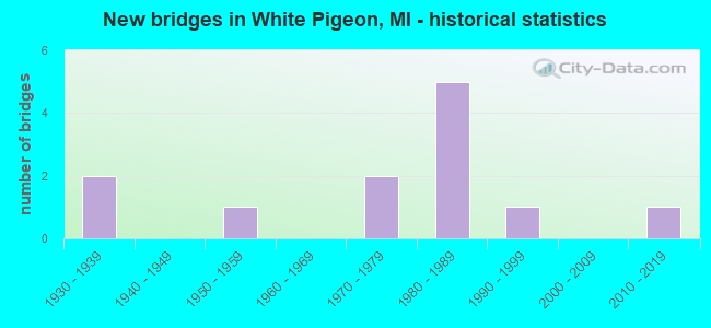
- New bridges - historical statistics
- 21930-1939
- 11950-1959
- 21970-1979
- 51980-1989
- 11990-1999
- 12010-2019

- Reconstructed bridges - Historical Statistics
- 11960-1969
- 01970-1979
- 01980-1989
- 11990-1999


- Bridge Condition - Deck
- 18.2%Very good
- 27.3%Good
- 36.4%Satisfactory
- 18.2%Poor

- Bridge Condition - Superstructure
- 18.2%Very good
- 9.1%Good
- 45.5%Satisfactory
- 9.1%Fair
- 9.1%Poor
- 9.1%Serious

- Bridge Condition - Substructure
- 9.1%Very good
- 45.5%Good
- 45.5%Satisfactory

- Bridge Condition - Channel
- 8.3%Very good
- 8.3%Good
- 25.0%Satisfactory
- 50.0%Fair
- 8.3%Poor
Find on map >> Show street view
Structure Number: 6784, Location: CITY OF BIG RAPIDS (Lat: 43.708908, Lng: -85.481192), Route carried "on" structure: City street , Year Built: 2016, Status: Open, Structure Length: 7.01m (23.00ft), Average Daily Traffic: 7,400 (year 2015), Truck Traffic: 5%, Average Future Daily Traffic: 13,000 (year 2035), Design Load: Greater than HL93, Features Intersected: MUSKEGON RIVER, Facility Carried by Structure: BALDWIN STREET
Minimum Vertical Clearance: 30.48m (100.00ft), Kilometerpoint: 1.014, Lanes on structure: 2, Owner: City or Municipal Highway Agency, Approaching Roadway Width: 11.0m (36.1ft), Material/Design: Prestressed concrete, Design/Construction: Box Beam or Girders - Single/Spread, Number Of Spans In Main Unit: 3, Length of Maximum Span: 31.5m (103.3ft), Curb or Sidewalk Widths: Left: 2.0m (6.6ft), Right: 2.0m (6.6ft), Curb-To-Curb Width: 11.0m (36.1ft), Out-to-Out Width: 15.9m (52.2ft)
Condition: Deck: Very good, Superstructure: Very good, Substructure: Very good, Channel: Very good, Operating Rating: 47.3 metric tons, Method Used To Determine Operating Rating: Load and Resistance Factor Rating (LRFR) rating reported by rating factor(RF) method using HL-93 loadings, Inventory Rating: 42.8 metric tons, Method Used To Determine Inventory Rating: Load and Resistance Factor Rating (LRFR) rating reported by rating factor(RF) method using HL-93 loadings, Structural Evaluation: Equal to present desirable criteria, Deck Geometry: Meets minimum limits, Waterway Adequacy: Better than present minimum criteria, Approach Roadway Alignment: Better than present minimum criteria, Designated Inspection Frequency: Every 24 months, Inspection Date: March 2020, Deck Structure Type: Concrete Cast-file-Place, Wearing Surface/Protective System: Wearing Surface: Monolithic Concrete, Deck Protection: Epoxy Coated Reinforcing
Find on map >> Show street view
Structure Number: 7012, Location: IN CITY OF MIDLAND (Lat: 43.641264, Lng: -84.272697), Route carried "on" structure: City street 2015, Year Built: 1931, Year Reconstructed: 1968, Status: Open, Structure Length: 0.61m (2.00ft), Average Daily Traffic: 17,000 (year 1990), Truck Traffic: 3%, Average Future Daily Traffic: 19,550 (year 2010), Design Load: HS 20+Mod, Features Intersected: STATE DRAIN, Facility Carried by Structure: N SAGINAW ROAD
Minimum Vertical Clearance: 30.48m (100.00ft), Kilometerpoint: 30.670, Lanes on structure: 2, Owner: City or Municipal Highway Agency, Approaching Roadway Width: 13.4m (44.0ft), Material/Design: Concrete, Design/Construction: Culvert, Number Of Spans In Main Unit: 1, Length of Maximum Span: 6.1m (20.0ft), Curb or Sidewalk Widths: Left: 1.5m (4.9ft), Right: 0.0m
Condition: Channel: Poor, Culverts: Satisfactory, Operating Rating: 55.0 metric tons, Method Used To Determine Operating Rating: Field evaluation and documented engineering judgment, Inventory Rating: 33.0 metric tons, Method Used To Determine Inventory Rating: Field evaluation and documented engineering judgment, Structural Evaluation: Equal to present minimum criteria, Waterway Adequacy: Equal to present minimum criteria, Approach Roadway Alignment: Equal to present desirable criteria, Designated Inspection Frequency: Every 24 months, Inspection Date: July 2020, Wearing Surface/Protective System: Wearing Surface: Bituminous
Find on map >> Show street view
Structure Number: 7013, Location: IN CITY OF MIDLAND (Lat: 43.641286, Lng: -84.266272), Route carried "on" structure: City street 2015, Year Built: 1931, Year Reconstructed: 1990, Status: Open, Structure Length: 1.52m (4.99ft), Average Daily Traffic: 20,000 (year 1985), Truck Traffic: 3%, Average Future Daily Traffic: 50,000 (year 2016), Design Load: HS 20, Features Intersected: STURGEON CREEK, Facility Carried by Structure: N SAGINAW ROAD
Minimum Vertical Clearance: 30.48m (100.00ft), Kilometerpoint: 31.189, Lanes on structure: 4, Owner: City or Municipal Highway Agency, Approaching Roadway Width: 13.4m (44.0ft), Material/Design: Steel, Design/Construction: Stringer/Multi-beam, Number Of Spans In Main Unit: 1, Length of Maximum Span: 14.6m (47.9ft), Curb or Sidewalk Widths: Left: 2.4m (7.9ft), Right: 1.5m (4.9ft), Curb-To-Curb Width: 20.7m (67.9ft), Out-to-Out Width: 25.9m (85.0ft)
Condition: Deck: Satisfactory, Superstructure: Satisfactory, Substructure: Satisfactory, Channel: Fair, Operating Rating: 70.0 metric tons, Method Used To Determine Operating Rating: Load Factor (LF) rating reported by rating factor (RF) method using MS18 loading, Inventory Rating: 41.8 metric tons, Method Used To Determine Inventory Rating: Load Factor (LF) rating reported by rating factor (RF) method using MS18 loading, Structural Evaluation: Equal to present minimum criteria, Deck Geometry: Superior to present desirable criteria, Waterway Adequacy: Equal to present minimum criteria, Approach Roadway Alignment: Equal to present desirable criteria, Designated Inspection Frequency: Every 24 months, Inspection Date: July 2020, Deck Structure Type: Concrete Cast-file-Place, Wearing Surface/Protective System: Wearing Surface: Monolithic Concrete, Deck Protection: Epoxy Coated Reinforcing
Find on map >> Show street view
Structure Number: 7313, Location: 0.55 MI N OF READY ROAD (Lat: 42.058339, Lng: -83.346331), Route carried "on" structure: County highway , Year Built: 1982, Status: Posted for load, Structure Length: 3.47m (11.38ft), Average Daily Traffic: 220 (year 2008), Truck Traffic: 14%, Average Future Daily Traffic: 253 (year 2028), Design Load: HS 20, Features Intersected: SWAN CREEK, Facility Carried by Structure: SWEITZER ROAD
Minimum Vertical Clearance: 30.48m (100.00ft), Kilometerpoint: 2.113, Lanes on structure: 2, Owner: County Highway Agency, Approaching Roadway Width: 7.9m (25.9ft), Skew: 3 degrees, Material/Design: Prestressed concrete, Design/Construction: Box Beam or Girders - Multiple, Number Of Spans In Main Unit: 3, Length of Maximum Span: 10.9m (35.8ft), Curb-To-Curb Width: 9.4m (30.8ft), Out-to-Out Width: 9.4m (30.8ft)
Condition: Deck: Poor, Superstructure: Serious, Substructure: Satisfactory, Channel: Fair, Operating Rating: 30.1 metric tons, Method Used To Determine Operating Rating: Load Factor (LF) rating reported by rating factor (RF) method using MS18 loading, Inventory Rating: 18.1 metric tons, Method Used To Determine Inventory Rating: Load Factor (LF) rating reported by rating factor (RF) method using MS18 loading, Structural Evaluation: High priority of corrective action, Deck Geometry: Equal to present minimum criteria, Waterway Adequacy: Equal to present minimum criteria, Approach Roadway Alignment: Equal to present minimum criteria, Bridge Posting: Required (Relationship of Operating Rating to Maximum Legal Load: > 39.9% below), Designated Inspection Frequency: Every 12 months, Inspection Date: November 2021, Deck Structure Type: Concrete Precast Panels, Wearing Surface/Protective System: Wearing Surface: Bituminous, Membrane: Other
Find on map >> Show street view
Structure Number: 7483, Location: 0.25 MI N OF CO 544 (Lat: 43.434694, Lng: -85.126694), Route carried "on" structure: County highway , Year Built: 1978, Status: Posted for load, Structure Length: 0.97m (3.18ft), Average Daily Traffic: 577 (year 2003), Truck Traffic: 5%, Average Future Daily Traffic: 753 (year 2023), Design Load: HS 20+Mod, Features Intersected: FLAT RIVER, Facility Carried by Structure: MUSSON ROAD
Minimum Vertical Clearance: 30.48m (100.00ft), Kilometerpoint: 10.794, Lanes on structure: 2, Owner: County Highway Agency, Approaching Roadway Width: 7.9m (25.9ft), Material/Design: Wood or Timber, Design/Construction: Slab, Number Of Spans In Main Unit: 1, Length of Maximum Span: 9.1m (29.9ft), Curb-To-Curb Width: 7.6m (24.9ft), Out-to-Out Width: 7.9m (25.9ft)
Condition: Deck: Satisfactory, Superstructure: Satisfactory, Substructure: Satisfactory, Channel: Satisfactory, Operating Rating: 35.0 metric tons, Method Used To Determine Operating Rating: Allowable Stress (AS), Inventory Rating: 24.0 metric tons, Method Used To Determine Inventory Rating: Allowable Stress (AS), Structural Evaluation: Equal to present minimum criteria, Deck Geometry: Meets minimum limits, Waterway Adequacy: Somewhat better than minimum adequacy, Approach Roadway Alignment: Equal to present desirable criteria, Bridge Posting: Required (Relationship of Operating Rating to Maximum Legal Load: 30.0 - 39.9% below), Designated Inspection Frequency: Every 24 months, Inspection Date: March 2021, Deck Structure Type: Wood or Timber, Wearing Surface/Protective System: Wearing Surface: Bituminous
Find on map >> Show street view
Structure Number: 7507, Location: STATION 0.02 W DERBY RD (Lat: 43.185103, Lng: -85.134003), Route carried "on" structure: County highway , Year Built: 1985, Status: Open, Structure Length: 0.70m (2.30ft), Average Daily Traffic: 107 (year 2003), Average Future Daily Traffic: 145 (year 2023), Design Load: HS 20+Mod, Features Intersected: DICKERSON CREEK, Facility Carried by Structure: STATION ROAD
Minimum Vertical Clearance: 30.48m (100.00ft), Kilometerpoint: 1.901, Lanes on structure: 2, Owner: County Highway Agency, Approaching Roadway Width: 7.3m (24.0ft), Material/Design: Wood or Timber, Design/Construction: Slab, Number Of Spans In Main Unit: 1, Length of Maximum Span: 7.0m (23.0ft), Curb-To-Curb Width: 7.3m (24.0ft), Out-to-Out Width: 7.8m (25.6ft)
Condition: Deck: Very good, Superstructure: Very good, Substructure: Good, Channel: Fair, Operating Rating: 51.1 metric tons, Method Used To Determine Operating Rating: Allowable Stress (AS), Inventory Rating: 35.7 metric tons, Method Used To Determine Inventory Rating: Allowable Stress (AS), Structural Evaluation: Better than present minimum criteria, Deck Geometry: Somewhat better than minimum adequacy, Waterway Adequacy: Equal to present minimum criteria, Approach Roadway Alignment: Equal to present desirable criteria, Designated Inspection Frequency: Every 24 months, Inspection Date: March 2021, Deck Structure Type: Wood or Timber, Wearing Surface/Protective System: Wearing Surface: Gravel
Find on map >> Show street view
Structure Number: 10268, Location: 4.4 MI E OF US-131 (Lat: 41.796456, Lng: -85.582342), Route carried "on" structure: US 12, Year Built: 1983, Status: Open, Structure Length: 3.35m (10.99ft), Average Daily Traffic: 5,925 (year 2007), Truck Traffic: 8%, Average Future Daily Traffic: 8,200 (year 2018), Design Load: HS 25 or greater, Features Intersected: FAWN RIVER
Minimum Vertical Clearance: 30.48m (100.00ft), Kilometerpoint: 14.969, Lanes on structure: 2, Base Highway Network: Yes (Inventory Route: 23, Subroute: 6), Owner: State Highway Agency, Approaching Roadway Width: 13.1m (43.0ft), Skew: 4 degrees, Material/Design: Steel, Design/Construction: Stringer/Multi-beam, Number Of Spans In Main Unit: 1, Length of Maximum Span: 33.5m (109.9ft), Curb-To-Curb Width: 14.6m (47.9ft), Out-to-Out Width: 15.6m (51.2ft)
Condition: Deck: Good, Superstructure: Satisfactory, Substructure: Good, Channel: Fair, Operating Rating: 70.6 metric tons, Method Used To Determine Operating Rating: Load Factor (LF) rating reported by rating factor (RF) method using MS18 loading, Inventory Rating: 42.4 metric tons, Method Used To Determine Inventory Rating: Load Factor (LF) rating reported by rating factor (RF) method using MS18 loading, Structural Evaluation: Equal to present minimum criteria, Deck Geometry: Superior to present desirable criteria, Waterway Adequacy: Equal to present desirable criteria, Approach Roadway Alignment: Equal to present minimum criteria, Designated Inspection Frequency: Every 24 months, Inspection Date: July 2021, Deck Structure Type: Concrete Cast-file-Place, Wearing Surface/Protective System: Wearing Surface: Monolithic Concrete, Deck Protection: Epoxy Coated Reinforcing
Find on map >> Show street view
Structure Number: 10269, Location: 2.4 MI N OF INDIANA STATE (Lat: 41.790461, Lng: -85.662586), Route carried "on" structure: US 131, Year Built: 1994, Status: Open, Structure Length: 3.41m (11.19ft), Average Daily Traffic: 9,556 (year 2007), Truck Traffic: 15%, Average Future Daily Traffic: 12,276 (year 2018), Design Load: HS 25 or greater, Features Intersected: WHITE PIGEON RIVER
Minimum Vertical Clearance: 30.48m (100.00ft), Kilometerpoint: 3.898, Lanes on structure: 2, Base Highway Network: Yes (Inventory Route: 23, Subroute: 1), Owner: State Highway Agency, Approaching Roadway Width: 12.8m (42.0ft), Material/Design: Prestressed concrete, Design/Construction: Box Beam or Girders - Multiple, Number Of Spans In Main Unit: 2, Length of Maximum Span: 17.0m (55.8ft), Curb-To-Curb Width: 15.9m (52.2ft), Out-to-Out Width: 16.8m (55.1ft)
Condition: Deck: Good, Superstructure: Satisfactory, Substructure: Good, Channel: Fair, Operating Rating: 82.3 metric tons, Method Used To Determine Operating Rating: Load Factor (LF) rating reported by rating factor (RF) method using MS18 loading, Inventory Rating: 47.3 metric tons, Method Used To Determine Inventory Rating: Load Factor (LF) rating reported by rating factor (RF) method using MS18 loading, Structural Evaluation: Equal to present minimum criteria, Deck Geometry: Superior to present desirable criteria, Waterway Adequacy: Better than present minimum criteria, Approach Roadway Alignment: Better than present minimum criteria, Designated Inspection Frequency: Every 24 months, Underwater Inspection Frequency: Every 60 months, Inspection Date: September 2021, Underwater Inspection Date: August 2017, Bridge Improvement Cost: $222,000, Deck Structure Type: Concrete Cast-file-Place, Wearing Surface/Protective System: Wearing Surface: Monolithic Concrete, Deck Protection: Epoxy Coated Reinforcing
Find on map >> Show street view
Structure Number: 10288, Location: 3.5 MI SE OF WHITE PIGEON (Lat: 41.780511, Lng: -85.583050), Route carried "on" structure: County highway 7812, Year Built: 1954, Status: Open, Structure Length: 2.43m (7.97ft), Average Daily Traffic: 1,011 (year 2003), Truck Traffic: 5%, Average Future Daily Traffic: 1,443 (year 2023), Design Load: H 20, Features Intersected: FAWN RIVER, Facility Carried by Structure: FAWN RIVER ROAD
Minimum Vertical Clearance: 30.48m (100.00ft), Kilometerpoint: 1.712, Lanes on structure: 2, Owner: County Highway Agency, Approaching Roadway Width: 9.1m (29.9ft), Material/Design: Steel, Design/Construction: Stringer/Multi-beam, Number Of Spans In Main Unit: 2, Length of Maximum Span: 12.2m (40.0ft), Curb or Sidewalk Widths: Left: 0.4m (1.3ft), Right: 0.4m (1.3ft), Curb-To-Curb Width: 7.0m (23.0ft), Out-to-Out Width: 8.9m (29.2ft)
Condition: Deck: Satisfactory, Superstructure: Fair, Substructure: Satisfactory, Channel: Satisfactory, Operating Rating: 53.4 metric tons, Method Used To Determine Operating Rating: Load Factor (LF), Inventory Rating: 32.0 metric tons, Method Used To Determine Inventory Rating: Load Factor (LF), Structural Evaluation: Somewhat better than minimum adequacy, Deck Geometry: High priority of corrective action, Waterway Adequacy: Equal to present minimum criteria, Approach Roadway Alignment: Equal to present desirable criteria, Designated Inspection Frequency: Every 24 months, Inspection Date: November 2021, Deck Structure Type: Concrete Cast-file-Place, Wearing Surface/Protective System: Wearing Surface: Bituminous
Find on map >> Show street view
Structure Number: 10328, Location: 3 MI S OF CONSTANTINE (Lat: 41.790114, Lng: -85.681625), Route carried "on" structure: County highway , Year Built: 1978, Status: Posted for load, Structure Length: 2.92m (9.58ft), Average Daily Traffic: 282 (year 2003), Truck Traffic: 8%, Average Future Daily Traffic: 401 (year 2023), Design Load: H 20, Features Intersected: WHITE PIGEON RIVER, Facility Carried by Structure: BLUE SCHOOL ROAD
Minimum Vertical Clearance: 30.48m (100.00ft), Kilometerpoint: 2.966, Lanes on structure: 2, Owner: County Highway Agency, Approaching Roadway Width: 10.1m (33.1ft), Skew: 1 degrees, Material/Design: Wood or Timber, Design/Construction: Slab, Number Of Spans In Main Unit: 4, Length of Maximum Span: 7.3m (24.0ft), Curb-To-Curb Width: 9.1m (29.9ft), Out-to-Out Width: 9.8m (32.2ft)
Condition: Deck: Poor, Superstructure: Poor, Substructure: Satisfactory, Channel: Fair, Operating Rating: 33.0 metric tons, Method Used To Determine Operating Rating: Allowable Stress (AS) rating reported by rating factor (RF) method using MS18 loading, Inventory Rating: 22.4 metric tons, Method Used To Determine Inventory Rating: Allowable Stress (AS) rating reported by rating factor (RF) method using MS18 loading, Structural Evaluation: Meets minimum limits, Deck Geometry: Equal to present minimum criteria, Waterway Adequacy: Better than present minimum criteria, Approach Roadway Alignment: Meets minimum limits, Bridge Posting: Required (Relationship of Operating Rating to Maximum Legal Load: 20.0 - 29.9% below), Designated Inspection Frequency: Every 12 months, Inspection Date: November 2021, Deck Structure Type: Wood or Timber, Wearing Surface/Protective System: Wearing Surface: Bituminous
Find on map >> Show street view
Structure Number: 10329, Location: 3 MI E OF WHITE PIGEON (Lat: 41.809658, Lng: -85.578411), Route carried "on" structure: County highway , Year Built: 1987, Status: Posted for load, Structure Length: 2.92m (9.58ft), Average Daily Traffic: 381 (year 2003), Truck Traffic: 5%, Average Future Daily Traffic: 543 (year 2023), Design Load: HS 20, Features Intersected: FAWN RIVER, Facility Carried by Structure: DICKINSON ROAD
Minimum Vertical Clearance: 30.48m (100.00ft), Kilometerpoint: 11.518, Lanes on structure: 2, Owner: County Highway Agency, Approaching Roadway Width: 10.1m (33.1ft), Material/Design: Wood or Timber, Design/Construction: Slab, Number Of Spans In Main Unit: 4, Length of Maximum Span: 7.3m (24.0ft), Curb-To-Curb Width: 10.1m (33.1ft), Out-to-Out Width: 10.3m (33.8ft)
Condition: Deck: Satisfactory, Superstructure: Satisfactory, Substructure: Good, Channel: Satisfactory, Operating Rating: 42.8 metric tons, Method Used To Determine Operating Rating: Allowable Stress (AS) rating reported by rating factor (RF) method using MS18 loading, Inventory Rating: 29.8 metric tons, Method Used To Determine Inventory Rating: Allowable Stress (AS) rating reported by rating factor (RF) method using MS18 loading, Structural Evaluation: Equal to present minimum criteria, Deck Geometry: Better than present minimum criteria, Waterway Adequacy: Equal to present minimum criteria, Approach Roadway Alignment: Equal to present desirable criteria, Bridge Posting: Required (Relationship of Operating Rating to Maximum Legal Load: 0.1 - 9.9% below), Designated Inspection Frequency: Every 24 months, Inspection Date: November 2021, Deck Structure Type: Wood or Timber, Wearing Surface/Protective System: Wearing Surface: Bituminous
Find on map >> Show street view
Structure Number: 1033, Location: 2 MI SE OF WHITE PIGEON (Lat: 41.773572, Lng: -85.603556), Route carried "on" structure: County highway , Year Built: 1984, Status: Open, Structure Length: 3.53m (11.58ft), Average Daily Traffic: 431 (year 2003), Truck Traffic: 5%, Average Future Daily Traffic: 620 (year 2023), Design Load: HS 20, Features Intersected: WHITE PIGEON RIVER, Facility Carried by Structure: SEVISON ROAD
Minimum Vertical Clearance: 30.48m (100.00ft), Kilometerpoint: 2.554, Lanes on structure: 2, Owner: County Highway Agency, Approaching Roadway Width: 9.1m (29.9ft), Material/Design: Prestressed concrete, Design/Construction: Box Beam or Girders - Multiple, Number Of Spans In Main Unit: 2, Length of Maximum Span: 17.6m (57.7ft), Curb-To-Curb Width: 9.1m (29.9ft), Out-to-Out Width: 9.4m (30.8ft)
Condition: Deck: Good, Superstructure: Good, Substructure: Good, Channel: Good, Operating Rating: 58.2 metric tons, Method Used To Determine Operating Rating: Load Factor (LF), Inventory Rating: 34.8 metric tons, Method Used To Determine Inventory Rating: Load Factor (LF), Structural Evaluation: Better than present minimum criteria, Deck Geometry: Equal to present minimum criteria, Waterway Adequacy: Equal to present desirable criteria, Approach Roadway Alignment: Equal to present desirable criteria, Designated Inspection Frequency: Every 24 months, Inspection Date: November 2021, Deck Structure Type: Other, Wearing Surface/Protective System: Wearing Surface: Bituminous, Membrane: Preformed Fabric