Bridge Statistics for White Haven, Pennsylvania (PA)
Condition, Traffic, Stress, Structural Evaluation, Project Costs
- National Bridge Inventory (NBI) Statistics
- 13Number of bridges
- 56ft / 17.4mTotal length
- $1,454,000Total costs
- 76,936Total average daily traffic
- 20,118Total average daily truck traffic
- National Bridge Inventory (NBI) Registered Bridges for White Haven
- No street view available for this location
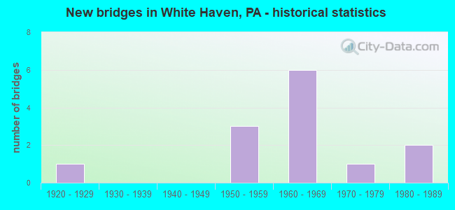
- New bridges - historical statistics
- 11920-1929
- 31950-1959
- 61960-1969
- 11970-1979
- 21980-1989

- Reconstructed bridges - Historical Statistics
- 21970-1979
- 01980-1989
- 11990-1999
- 02000-2009
- 12010-2019


- Bridge Condition - Deck
- 11.1%Very good
- 11.1%Good
- 22.2%Satisfactory
- 44.4%Fair
- 11.1%Poor

- Bridge Condition - Superstructure
- 11.1%Good
- 44.4%Satisfactory
- 44.4%Fair

- Bridge Condition - Substructure
- 33.3%Satisfactory
- 22.2%Fair
- 44.4%Poor

- Bridge Condition - Channel
- 10.0%Very good
- 10.0%Good
- 40.0%Satisfactory
- 20.0%Fair
- 20.0%Poor

- Bridge Condition - Culverts
- 50.0%Satisfactory
- 50.0%Fair
Find on map >> Show street view
Structure Number: 5071, Location: KAUFFMAN RD.@ BERTLET MIL (Lat: 40.378414, Lng: -75.774003), Route carried "on" structure: State highway , Year Built: 1923, Status: Open, Structure Length: 0.85m (2.79ft), Average Daily Traffic: 256 (year 2020), Truck Traffic: 6%, Average Future Daily Traffic: 356 (year 2032), Features Intersected: LITTLE MANATAWNY CREEK, Facility Carried by Structure: SR 2024 (LR 06086)
Minimum Vertical Clearance: 30+ m (98+ ft), Kilometerpoint: 0.000, Lanes on structure: 2, Owner: State Highway Agency, Approaching Roadway Width: 6.1m (20.0ft), Material/Design: Concrete, Design/Construction: Tee Beam, Number Of Spans In Main Unit: 1, Length of Maximum Span: 7.3m (24.0ft), Curb-To-Curb Width: 5.7m (18.7ft), Out-to-Out Width: 6.7m (22.0ft)
Condition: Deck: Fair, Superstructure: Satisfactory, Substructure: Poor, Channel: Fair, Operating Rating: 49.0 metric tons, Method Used To Determine Operating Rating: Field evaluation and documented engineering judgment, Inventory Rating: 32.7 metric tons, Method Used To Determine Inventory Rating: Field evaluation and documented engineering judgment, Structural Evaluation: Meets minimum limits, Deck Geometry: High priority of corrective action, Waterway Adequacy: Superior to present desirable criteria, Approach Roadway Alignment: Equal to present minimum criteria, Length Of Structure Improvement: 1.50m (4.92ft), Designated Inspection Frequency: Every 24 months, Inspection Date: November 2021, Bridge Improvement Cost: $2,000, Roadway Improvement Cost: $7,000, Total Project Cost: $30,000, Deck Structure Type: Concrete Cast-file-Place, Wearing Surface/Protective System: Wearing Surface: Bituminous
Find on map >> Show street view
Structure Number: 8781, Location: JOHNSTOWN,REAM PLACE (Lat: 40.309294, Lng: -78.907489), Route carried "on" structure: City street , Year Built: 1987, Status: Open, Structure Length: 0.91m (2.99ft), Average Daily Traffic: 51 (year 2021), Truck Traffic: 1%, Average Future Daily Traffic: 63 (year 2041), Design Load: HS 20, Features Intersected: SOLOMON RUN, Facility Carried by Structure: REAM PLACE
Minimum Vertical Clearance: 30+ m (98+ ft), Kilometerpoint: 0.000, Lanes on structure: 1, Owner: City or Municipal Highway Agency, Approaching Roadway Width: 3.4m (11.2ft), Skew: 2 degrees, Material/Design: Prestressed concrete, Design/Construction: Box Beam or Girders - Multiple, Number Of Spans In Main Unit: 1, Length of Maximum Span: 8.2m (26.9ft), Curb-To-Curb Width: 3.2m (10.5ft), Out-to-Out Width: 3.7m (12.1ft)
Condition: Deck: Fair, Superstructure: Fair, Substructure: Satisfactory, Channel: Very good, Operating Rating: 59.9 metric tons, Method Used To Determine Operating Rating: Load Factor (LF), Inventory Rating: 35.4 metric tons, Method Used To Determine Inventory Rating: Load Factor (LF), Structural Evaluation: Somewhat better than minimum adequacy, Deck Geometry: High priority of replacement, Waterway Adequacy: Better than present minimum criteria, Approach Roadway Alignment: Equal to present desirable criteria, Length Of Structure Improvement: 1.60m (5.25ft), Designated Inspection Frequency: Every 24 months, Inspection Date: July 2021, Bridge Improvement Cost: $1,000, Roadway Improvement Cost: $4,000, Total Project Cost: $18,000, Deck Structure Type: Other, Wearing Surface/Protective System: Wearing Surface: Bituminous, Membrane: Other
Find on map >> Show street view
Structure Number: 8791, Location: DALE BORO.@ VON LUNEN ST. (Lat: 40.309897, Lng: -78.906300), Route carried "on" structure: City street , Year Built: 1987, Year Reconstructed: 2018, Status: Open, Structure Length: 1.16m (3.81ft), Average Daily Traffic: 550 (year 2020), Truck Traffic: 1%, Average Future Daily Traffic: 688 (year 2040), Design Load: HS 20, Features Intersected: SOLOMON RUN, Facility Carried by Structure: VON LUNEN STREET
Minimum Vertical Clearance: 30+ m (98+ ft), Kilometerpoint: 0.000, Lanes on structure: 2, Owner: County Highway Agency, Approaching Roadway Width: 7.3m (24.0ft), Skew: 2 degrees, Material/Design: Prestressed concrete, Design/Construction: Box Beam or Girders - Multiple, Number Of Spans In Main Unit: 1, Length of Maximum Span: 11.0m (36.1ft), Curb or Sidewalk Widths: Left: 1.8m (5.9ft), Right: 1.8m (5.9ft), Curb-To-Curb Width: 7.3m (24.0ft), Out-to-Out Width: 11.7m (38.4ft)
Condition: Deck: Very good, Superstructure: Satisfactory, Substructure: Satisfactory, Channel: Good, Operating Rating: 98.9 metric tons, Method Used To Determine Operating Rating: Load Factor (LF), Inventory Rating: 56.2 metric tons, Method Used To Determine Inventory Rating: Load Factor (LF), Structural Evaluation: Equal to present minimum criteria, Deck Geometry: Meets minimum limits, Waterway Adequacy: Equal to present desirable criteria, Approach Roadway Alignment: Equal to present desirable criteria, Length Of Structure Improvement: 1.50m (4.92ft), Designated Inspection Frequency: Every 24 months, Inspection Date: December 2020, Wearing Surface/Protective System: Wearing Surface: Monolithic Concrete, Deck Protection: Epoxy Coated Reinforcing
Find on map >> Show street view
Structure Number: 9109, Location: LUZERNE CO.LINE (Lat: 40.996842, Lng: -75.760675), Route carried "on" structure: State highway , Year Built: 1950, Status: Open, Structure Length: 0.73m (2.40ft), Average Daily Traffic: 1,645 (year 2022), Truck Traffic: 6%, Average Future Daily Traffic: 2,446 (year 2036), Design Load: HS 20, Features Intersected: LESLIE RUN, Facility Carried by Structure: SR 4010(APPL 1012)
Minimum Vertical Clearance: 30+ m (98+ ft), Kilometerpoint: 22.637, Lanes on structure: 2, Owner: State Highway Agency, Approaching Roadway Width: 9.8m (32.2ft), Material/Design: Concrete, Design/Construction: Culvert, Number Of Spans In Main Unit: 1, Length of Maximum Span: 6.1m (20.0ft)
Condition: Channel: Satisfactory, Culverts: Satisfactory, Inventory Rating: 63.5 metric tons, Method Used To Determine Inventory Rating: Load Factor (LF), Structural Evaluation: Equal to present minimum criteria, Waterway Adequacy: Equal to present minimum criteria, Approach Roadway Alignment: Equal to present desirable criteria, Length Of Structure Improvement: 1.20m (3.94ft), Designated Inspection Frequency: Every 24 months, Inspection Date: November 2020
Find on map >> Show street view
Structure Number: 16951, Location: GEORGES TOWNSHIP (Lat: 39.808289, Lng: -79.767753), Route carried "on" structure: State highway , Year Built: 1979, Status: Open, Structure Length: 1.52m (4.99ft), Average Daily Traffic: 4,457 (year 2022), Truck Traffic: 7%, Average Future Daily Traffic: 4,665 (year 2032), Design Load: HS 20+Mod, Features Intersected: GEORGE CREEK, Facility Carried by Structure: SR 3029
Minimum Vertical Clearance: 30+ m (98+ ft), Kilometerpoint: 0.000, Lanes on structure: 2, Owner: State Highway Agency, Approaching Roadway Width: 7.3m (24.0ft), Skew: 4 degrees, Material/Design: Prestressed concrete, Design/Construction: Box Beam or Girders - Multiple, Number Of Spans In Main Unit: 1, Length of Maximum Span: 14.6m (47.9ft), Curb-To-Curb Width: 8.5m (27.9ft), Out-to-Out Width: 9.8m (32.2ft)
Condition: Deck: Satisfactory, Superstructure: Fair, Substructure: Satisfactory, Channel: Fair, Operating Rating: 81.6 metric tons, Method Used To Determine Operating Rating: Load Factor (LF), Inventory Rating: 45.4 metric tons, Method Used To Determine Inventory Rating: Load Factor (LF), Structural Evaluation: Somewhat better than minimum adequacy, Deck Geometry: Meets minimum limits, Waterway Adequacy: Superior to present desirable criteria, Approach Roadway Alignment: Equal to present desirable criteria, Length Of Structure Improvement: 2.20m (7.22ft), Designated Inspection Frequency: Every 24 months, Inspection Date: March 2021, Bridge Improvement Cost: $5,000, Roadway Improvement Cost: $15,000, Total Project Cost: $69,000, Deck Structure Type: Other, Wearing Surface/Protective System: Wearing Surface: Bituminous, Membrane: Preformed Fabric
Find on map >> Show street view
Structure Number: 23677, Location: WHITE HAVN BO .5M W TR940 (Lat: 41.056672, Lng: -75.790961), Route carried "on" structure: Interstate 80, Year Built: 1966, Year Reconstructed: 1983, Status: Open, Structure Length: 0.82m (2.69ft), Average Daily Traffic: 12,168 (year 2021), Truck Traffic: 40%, Average Future Daily Traffic: 12,496 (year 2032), Design Load: HS 20+Mod, Features Intersected: LINESVILLE CREEK
Minimum Vertical Clearance: 30+ m (98+ ft), Kilometerpoint: 39.056, Lanes on structure: 2, Base Highway Network: Yes, Owner: State Highway Agency, Approaching Roadway Width: 11.6m (38.1ft), Skew: 12 degrees, Material/Design: Prestressed concrete, Design/Construction: Box Beam or Girders - Single/Spread, Number Of Spans In Main Unit: 1, Length of Maximum Span: 7.9m (25.9ft), Curb or Sidewalk Widths: Left: 0.2m (0.7ft), Right: 0.2m (0.7ft), Curb-To-Curb Width: 12.4m (40.7ft), Out-to-Out Width: 13.9m (45.6ft)
Condition: Deck: Fair, Superstructure: Fair, Substructure: Poor, Channel: Satisfactory, Operating Rating: 59.0 metric tons, Method Used To Determine Operating Rating: Load Factor (LF), Inventory Rating: 35.4 metric tons, Method Used To Determine Inventory Rating: Load Factor (LF), Structural Evaluation: Meets minimum limits, Deck Geometry: Better than present minimum criteria, Waterway Adequacy: Equal to present minimum criteria, Approach Roadway Alignment: Equal to present desirable criteria, Length Of Structure Improvement: 0.80m (2.62ft), Designated Inspection Frequency: Every 24 months, Inspection Date: September 2021, Bridge Improvement Cost: $13,000, Roadway Improvement Cost: $100,000, Total Project Cost: $173,000, Deck Structure Type: Concrete Cast-file-Place, Wearing Surface/Protective System: Wearing Surface: Latex Concrete
Find on map >> Show street view
Structure Number: 23678, Location: WHITE HAVEN B .5M W TR940 (Lat: 41.057011, Lng: -75.791286), Route carried "on" structure: Interstate 80, Year Built: 1966, Year Reconstructed: 1983, Status: Open, Structure Length: 0.82m (2.69ft), Average Daily Traffic: 12,150 (year 2021), Truck Traffic: 41%, Average Future Daily Traffic: 12,854 (year 2032), Design Load: HS 20+Mod, Features Intersected: LINESVILLE CREEK
Minimum Vertical Clearance: 30+ m (98+ ft), Kilometerpoint: 39.007, Lanes on structure: 2, Base Highway Network: Yes, Owner: State Highway Agency, Approaching Roadway Width: 11.6m (38.1ft), Skew: 12 degrees, Material/Design: Prestressed concrete, Design/Construction: Box Beam or Girders - Single/Spread, Number Of Spans In Main Unit: 1, Length of Maximum Span: 7.9m (25.9ft), Curb or Sidewalk Widths: Left: 0.2m (0.7ft), Right: 0.2m (0.7ft), Curb-To-Curb Width: 12.4m (40.7ft), Out-to-Out Width: 13.9m (45.6ft)
Condition: Deck: Fair, Superstructure: Satisfactory, Substructure: Poor, Channel: Satisfactory, Operating Rating: 59.0 metric tons, Method Used To Determine Operating Rating: Load Factor (LF), Inventory Rating: 35.4 metric tons, Method Used To Determine Inventory Rating: Load Factor (LF), Structural Evaluation: Meets minimum limits, Deck Geometry: Better than present minimum criteria, Waterway Adequacy: Equal to present minimum criteria, Approach Roadway Alignment: Equal to present desirable criteria, Length Of Structure Improvement: 0.80m (2.62ft), Designated Inspection Frequency: Every 24 months, Inspection Date: September 2021, Bridge Improvement Cost: $13,000, Roadway Improvement Cost: $100,000, Total Project Cost: $173,000, Deck Structure Type: Concrete Cast-file-Place, Wearing Surface/Protective System: Wearing Surface: Latex Concrete
Find on map >> Show street view
Structure Number: 23955, Location: W HAVEN BORO 200' S I-80 (Lat: 41.054111, Lng: -75.775858), Route carried "on" structure: State highway 940, Year Built: 1966, Status: Open, Structure Length: 0.70m (2.30ft), Average Daily Traffic: 5,498 (year 2022), Truck Traffic: 5%, Average Future Daily Traffic: 7,704 (year 2032), Design Load: HS 20+Mod, Features Intersected: LINESVILLE CREEK
Minimum Vertical Clearance: 30+ m (98+ ft), Kilometerpoint: 22.153, Lanes on structure: 3, Base Highway Network: Yes, Owner: State Highway Agency, Approaching Roadway Width: 19.2m (63.0ft), Skew: 22 degrees, Material/Design: Concrete, Design/Construction: Culvert, Number Of Spans In Main Unit: 1, Length of Maximum Span: 7.0m (23.0ft)
Condition: Channel: Poor, Culverts: Fair, Operating Rating: 49.0 metric tons, Method Used To Determine Operating Rating: Field evaluation and documented engineering judgment, Inventory Rating: 32.7 metric tons, Method Used To Determine Inventory Rating: Field evaluation and documented engineering judgment, Structural Evaluation: Somewhat better than minimum adequacy, Waterway Adequacy: Superior to present desirable criteria, Approach Roadway Alignment: Equal to present desirable criteria, Length Of Structure Improvement: 0.70m (2.30ft), Designated Inspection Frequency: Every 24 months, Inspection Date: January 2021, Bridge Improvement Cost: $10,000, Roadway Improvement Cost: $29,000, Total Project Cost: $133,000
Find on map >> Show street view
Structure Number: 23956, Location: WHITE HAVEN BOR OVER I-80 (Lat: 41.055000, Lng: -75.780000), Route carried "on" structure: State highway 940, Year Built: 1966, Year Reconstructed: 1990, Status: Open, Structure Length: 6.71m (22.01ft), Average Daily Traffic: 5,498 (year 2022), Truck Traffic: 5%, Average Future Daily Traffic: 7,704 (year 2033), Design Load: HS 20, Features Intersected: SR 0080 I-80 EB & WB
Minimum Vertical Clearance: 30+ m (98+ ft), Kilometerpoint: 22.153, Lanes on structure: 4, Lanes under structure: 8, Base Highway Network: Yes, Owner: State Highway Agency, Approaching Roadway Width: 18.0m (59.1ft), Skew: 21 degrees, Material/Design: Prestressed concrete, Design/Construction: Box Beam or Girders - Single/Spread, Number Of Spans In Main Unit: 4, Length of Maximum Span: 21.0m (68.9ft), Curb or Sidewalk Widths: Left: 0.2m (0.7ft), Right: 0.2m (0.7ft), Curb-To-Curb Width: 19.3m (63.3ft), Out-to-Out Width: 20.0m (65.6ft)
Condition: Deck: Good, Superstructure: Fair, Substructure: Fair, Operating Rating: 76.2 metric tons, Method Used To Determine Operating Rating: Load Factor (LF), Inventory Rating: 29.9 metric tons, Method Used To Determine Inventory Rating: Load Factor (LF), Structural Evaluation: Somewhat better than minimum adequacy, Deck Geometry: Equal to present minimum criteria, Underclear: Meets minimum limits, Approach Roadway Alignment: Equal to present desirable criteria, Length Of Structure Improvement: 6.70m (21.98ft), Designated Inspection Frequency: Every 24 months, Inspection Date: January 2021, Bridge Improvement Cost: $21,000, Roadway Improvement Cost: $62,000, Total Project Cost: $284,000, Deck Structure Type: Concrete Cast-file-Place, Wearing Surface/Protective System: Wearing Surface: Monolithic Concrete, Deck Protection: Epoxy Coated Reinforcing
Find on map >> Show street view
Structure Number: 24168, Location: FOSTER TWP 1.7M S SR 2046 (Lat: 41.008878, Lng: -75.768736), Route carried "on" structure: State highway , Year Built: 1959, Status: Open, Structure Length: 1.46m (4.79ft), Average Daily Traffic: 1,640 (year 2022), Truck Traffic: 6%, Average Future Daily Traffic: 2,451 (year 2033), Design Load: HS 20, Features Intersected: SANDY RUN, Facility Carried by Structure: SR 2055
Minimum Vertical Clearance: 30+ m (98+ ft), Kilometerpoint: 0.777, Lanes on structure: 2, Owner: State Highway Agency, Approaching Roadway Width: 7.0m (23.0ft), Skew: 1 degrees, Material/Design: Prestressed concrete, Design/Construction: Box Beam or Girders - Single/Spread, Number Of Spans In Main Unit: 1, Length of Maximum Span: 14.3m (46.9ft), Curb or Sidewalk Widths: Left: 0.5m (1.6ft), Right: 0.5m (1.6ft), Curb-To-Curb Width: 11.4m (37.4ft), Out-to-Out Width: 13.3m (43.6ft)
Condition: Deck: Poor, Superstructure: Satisfactory, Substructure: Fair, Channel: Poor, Operating Rating: 98.0 metric tons, Method Used To Determine Operating Rating: Load Factor (LF), Inventory Rating: 42.6 metric tons, Method Used To Determine Inventory Rating: Load Factor (LF), Structural Evaluation: Somewhat better than minimum adequacy, Deck Geometry: Equal to present minimum criteria, Waterway Adequacy: Equal to present minimum criteria, Approach Roadway Alignment: Equal to present desirable criteria, Length Of Structure Improvement: 1.50m (4.92ft), Designated Inspection Frequency: Every 24 months, Inspection Date: January 2021, Bridge Improvement Cost: $18,000, Roadway Improvement Cost: $100,000, Total Project Cost: $240,000, Deck Structure Type: Concrete Cast-file-Place, Wearing Surface/Protective System: Wearing Surface: Integral Concrete
Find on map >> Show street view
Structure Number: 24169, Location: FOSTER TWP 1.5M S SR 2046 (Lat: 41.010239, Lng: -75.771353), Route carried "on" structure: State highway , Year Built: 1959, Status: Open, Structure Length: 1.77m (5.81ft), Average Daily Traffic: 1,640 (year 2022), Truck Traffic: 6%, Average Future Daily Traffic: 2,451 (year 2032), Design Load: HS 20, Features Intersected: POND CREEK, Facility Carried by Structure: SR 2055
Minimum Vertical Clearance: 30+ m (98+ ft), Kilometerpoint: 1.574, Lanes on structure: 2, Owner: State Highway Agency, Approaching Roadway Width: 7.0m (23.0ft), Skew: 1 degrees, Material/Design: Prestressed concrete, Design/Construction: Box Beam or Girders - Single/Spread, Number Of Spans In Main Unit: 1, Length of Maximum Span: 17.1m (56.1ft), Curb or Sidewalk Widths: Left: 0.5m (1.6ft), Right: 0.5m (1.6ft), Curb-To-Curb Width: 11.4m (37.4ft), Out-to-Out Width: 13.3m (43.6ft)
Condition: Deck: Satisfactory, Superstructure: Good, Substructure: Poor, Channel: Satisfactory, Operating Rating: 92.5 metric tons, Method Used To Determine Operating Rating: Load Factor (LF), Inventory Rating: 43.5 metric tons, Method Used To Determine Inventory Rating: Load Factor (LF), Structural Evaluation: Meets minimum limits, Deck Geometry: Equal to present minimum criteria, Waterway Adequacy: Equal to present minimum criteria, Approach Roadway Alignment: Better than present minimum criteria, Length Of Structure Improvement: 1.80m (5.91ft), Designated Inspection Frequency: Every 24 months, Inspection Date: January 2021, Bridge Improvement Cost: $25,000, Roadway Improvement Cost: $121,000, Total Project Cost: $334,000, Deck Structure Type: Concrete Cast-file-Place, Wearing Surface/Protective System: Wearing Surface: Integral Concrete
Find on map >> Show street view
Structure Number: 23956, Location: WHITE HAVEN BOR OVER I-80 (Lat: 41.055000, Lng: -75.780000), Route carried "under" structure: Interstate 80, Year Built: 1966, Structure Length: 0. m, Average Daily Traffic: 15,840 (year 2020), Truck Traffic: 28%, Features Intersected: SR 0080 I-80 EB & WB, Facility Carried by Structure: SR 0940 TR 940
Minimum Vertical Clearance: 5.33m (17.49ft), Kilometerpoint: 40.649, Lanes on structure: 4, Lanes under structure: 4, Material/Design: Prestressed concrete, Design/Construction: Box Beam or Girders - Single/Spread, Length of Maximum Span: 21.0m (68.9ft)
Find on map >> Show street view
Structure Number: 23956, Location: WHITE HAVEN BOR OVER I-80 (Lat: 41.055000, Lng: -75.780000), Route carried "under" structure: Interstate 80, Year Built: 1966, Structure Length: 0. m, Average Daily Traffic: 15,543 (year 2020), Truck Traffic: 30%, Features Intersected: SR 0080 I-80 EB & WB, Facility Carried by Structure: SR 0940 TR 940
Minimum Vertical Clearance: 5.33m (17.49ft), Kilometerpoint: 40.699, Lanes on structure: 4, Lanes under structure: 4, Material/Design: Prestressed concrete, Design/Construction: Box Beam or Girders - Single/Spread, Length of Maximum Span: 21.0m (68.9ft)