Bridge Statistics for White Bluff, Tennessee (TN)
Condition, Traffic, Stress, Structural Evaluation, Project Costs
- National Bridge Inventory (NBI) Statistics
- 15Number of bridges
- 69ft / 21.0mTotal length
- $2,419,000Total costs
- 27,871Total average daily traffic
- 1,600Total average daily truck traffic
- National Bridge Inventory (NBI) Registered Bridges for White Bluff
- No street view available for this location
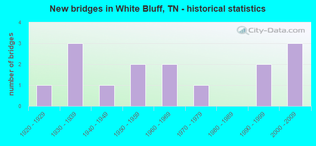
- New bridges - historical statistics
- 11920-1929
- 31930-1939
- 11940-1949
- 21950-1959
- 21960-1969
- 11970-1979
- 21990-1999
- 32000-2009

- Reconstructed bridges - Historical Statistics
- 11970-1979
- 01980-1989
- 11990-1999


- Bridge Condition - Deck
- 14.3%Very good
- 57.1%Good
- 28.6%Satisfactory

- Bridge Condition - Superstructure
- 14.3%Very good
- 42.9%Good
- 42.9%Satisfactory

- Bridge Condition - Substructure
- 57.1%Good
- 28.6%Satisfactory
- 14.3%Fair

- Bridge Condition - Channel
- 71.4%Good
- 28.6%Satisfactory

- Bridge Condition - Culverts
- 85.7%Good
- 14.3%Satisfactory
Find on map >> Show street view
Structure Number: 110A4670001, Location: 1 M.E. DICKSON CO. LN. (Lat: 36.148617, Lng: -87.145983), Route carried "on" structure: County highway 467, Year Built: 1950, Year Reconstructed: 1984, Status: Posted for load, Structure Length: 0.98m (3.22ft), Average Daily Traffic: 50 (year 2022), Truck Traffic: 4%, Average Future Daily Traffic: 80 (year 2040), Design Load: H 15, Features Intersected: LEATHERWOOD CREEK
Minimum Vertical Clearance: 30+ m (98+ ft), Kilometerpoint: 0.026, Lanes on structure: 1, Owner: County Highway Agency, Approaching Roadway Width: 3.7m (12.1ft), Material/Design: Steel, Design/Construction: Stringer/Multi-beam, Number Of Spans In Main Unit: 1, Length of Maximum Span: 9.1m (29.9ft), Curb-To-Curb Width: 4.4m (14.4ft), Out-to-Out Width: 5.3m (17.4ft)
Condition: Deck: Good, Superstructure: Satisfactory, Substructure: Fair, Channel: Satisfactory, Operating Rating: 40.5 metric tons, Method Used To Determine Operating Rating: Load Factor (LF), Inventory Rating: 24.3 metric tons, Method Used To Determine Inventory Rating: Load Factor (LF), Structural Evaluation: Somewhat better than minimum adequacy, Deck Geometry: Equal to present minimum criteria, Waterway Adequacy: Somewhat better than minimum adequacy, Approach Roadway Alignment: Equal to present desirable criteria, Length Of Structure Improvement: 0.98m (3.22ft), Designated Inspection Frequency: Every 24 months, Inspection Date: September 2020, Bridge Improvement Cost: $145,000, Roadway Improvement Cost: $15,000, Total Project Cost: $218,000 ( Estimate for 2020), Deck Structure Type: Concrete Cast-file-Place, Wearing Surface/Protective System: Wearing Surface: Monolithic Concrete
Find on map >> Show street view
Structure Number: 22018470001, Location: 1.75 M. N. I40. (Lat: 36.062867, Lng: -87.221233), Route carried "on" structure: County highway 1847, Year Built: 1968, Status: Open, Structure Length: 3.38m (11.09ft), Average Daily Traffic: 2,450 (year 2020), Truck Traffic: 3%, Average Future Daily Traffic: 3,520 (year 2040), Design Load: HS 20, Features Intersected: BEAVER DAM CREEK
Minimum Vertical Clearance: 30+ m (98+ ft), Kilometerpoint: 3.283, Lanes on structure: 2, Owner: County Highway Agency, Approaching Roadway Width: 8.5m (27.9ft), Skew: 2 degrees, Material/Design: Prestressed concrete continuous, Design/Construction: Stringer/Multi-beam, Number Of Spans In Main Unit: 2, Length of Maximum Span: 16.8m (55.1ft), Curb-To-Curb Width: 8.7m (28.5ft), Out-to-Out Width: 9.9m (32.5ft)
Condition: Deck: Good, Superstructure: Good, Substructure: Good, Channel: Good, Operating Rating: 54.9 metric tons, Method Used To Determine Operating Rating: Load Factor (LF), Inventory Rating: 32.4 metric tons, Method Used To Determine Inventory Rating: Load Factor (LF), Structural Evaluation: Better than present minimum criteria, Deck Geometry: Meets minimum limits, Waterway Adequacy: Equal to present minimum criteria, Approach Roadway Alignment: Equal to present minimum criteria, Designated Inspection Frequency: Every 24 months, Inspection Date: July 2020, Deck Structure Type: Concrete Cast-file-Place, Wearing Surface/Protective System: Wearing Surface: Bituminous
Find on map >> Show street view
Structure Number: 22018470003, Location: 2.25 M. N. I40 (Lat: 36.067700, Lng: -87.221367), Route carried "on" structure: County highway 1847, Year Built: 1968, Status: Open, Structure Length: 3.38m (11.09ft), Average Daily Traffic: 2,450 (year 2020), Truck Traffic: 3%, Average Future Daily Traffic: 3,520 (year 2040), Design Load: HS 20, Features Intersected: FIVE MILE CREEK
Minimum Vertical Clearance: 30+ m (98+ ft), Kilometerpoint: 4.039, Lanes on structure: 2, Owner: County Highway Agency, Approaching Roadway Width: 7.9m (25.9ft), Skew: 2 degrees, Material/Design: Prestressed concrete continuous, Design/Construction: Stringer/Multi-beam, Number Of Spans In Main Unit: 2, Length of Maximum Span: 16.8m (55.1ft), Curb-To-Curb Width: 8.7m (28.5ft), Out-to-Out Width: 9.9m (32.5ft)
Condition: Deck: Good, Superstructure: Good, Substructure: Good, Channel: Satisfactory, Operating Rating: 45.9 metric tons, Method Used To Determine Operating Rating: Load Factor (LF), Inventory Rating: 32.4 metric tons, Method Used To Determine Inventory Rating: Load Factor (LF), Structural Evaluation: Better than present minimum criteria, Deck Geometry: Meets minimum limits, Waterway Adequacy: Equal to present minimum criteria, Approach Roadway Alignment: Equal to present desirable criteria, Designated Inspection Frequency: Every 24 months, Inspection Date: July 2020, Deck Structure Type: Concrete Cast-file-Place, Wearing Surface/Protective System: Wearing Surface: Bituminous
Find on map >> Show street view
Structure Number: 220A2280007, Location: DAWSON ROAD (Lat: 36.133367, Lng: -87.278133), Route carried "on" structure: County highway 228, Year Built: 2007, Status: Open, Structure Length: 1.83m (6.00ft), Average Daily Traffic: 490 (year 2022), Truck Traffic: 2%, Average Future Daily Traffic: 784 (year 2040), Design Load: HS 20, Features Intersected: JOSLIN BRANCH
Minimum Vertical Clearance: 30+ m (98+ ft), Kilometerpoint: 2.832, Lanes on structure: 2, Owner: County Highway Agency, Approaching Roadway Width: 6.1m (20.0ft), Skew: 2 degrees, Material/Design: Prestressed concrete, Design/Construction: Box Beam or Girders - Single/Spread, Number Of Spans In Main Unit: 1, Length of Maximum Span: 16.8m (55.1ft), Curb-To-Curb Width: 7.3m (24.0ft), Out-to-Out Width: 8.0m (26.2ft)
Condition: Deck: Very good, Superstructure: Very good, Substructure: Good, Channel: Satisfactory, Operating Rating: 62.1 metric tons, Method Used To Determine Operating Rating: Load Factor (LF), Inventory Rating: 32.4 metric tons, Method Used To Determine Inventory Rating: Load Factor (LF), Structural Evaluation: Better than present minimum criteria, Deck Geometry: Meets minimum limits, Waterway Adequacy: Equal to present desirable criteria, Approach Roadway Alignment: Equal to present desirable criteria, Designated Inspection Frequency: Every 24 months, Inspection Date: July 2020, Deck Structure Type: Concrete Cast-file-Place, Wearing Surface/Protective System: Wearing Surface: Monolithic Concrete, Deck Protection: Epoxy Coated Reinforcing
Find on map >> Show street view
Structure Number: 220A2500001, Location: WORK ROAD - DICKSON CO (Lat: 36.063050, Lng: -87.227450), Route carried "on" structure: County highway 250, Year Built: 1970, Status: Open, Structure Length: 0.70m (2.30ft), Average Daily Traffic: 100 (year 2022), Truck Traffic: 2%, Average Future Daily Traffic: 160 (year 2040), Design Load: HS 20, Features Intersected: BRANCH
Minimum Vertical Clearance: 30+ m (98+ ft), Kilometerpoint: 2.334, Lanes on structure: 2, Owner: County Highway Agency, Approaching Roadway Width: 7.0m (23.0ft), Skew: 4 degrees, Material/Design: Concrete, Design/Construction: Culvert, Number Of Spans In Main Unit: 1, Length of Maximum Span: 6.4m (21.0ft), Curb-To-Curb Width: 7.4m (24.3ft), Out-to-Out Width: 8.0m (26.2ft)
Condition: Channel: Good, Culverts: Good, Operating Rating: 44.1 metric tons, Method Used To Determine Operating Rating: Field evaluation and documented engineering judgment, Inventory Rating: 32.4 metric tons, Method Used To Determine Inventory Rating: Field evaluation and documented engineering judgment, Structural Evaluation: Better than present minimum criteria, Deck Geometry: Equal to present minimum criteria, Waterway Adequacy: Equal to present desirable criteria, Approach Roadway Alignment: Equal to present minimum criteria, Designated Inspection Frequency: Every 24 months, Inspection Date: July 2020, Deck Structure Type: Concrete Cast-file-Place, Wearing Surface/Protective System: Wearing Surface: Bituminous, Deck Protection: Epoxy Coated Reinforcing
Find on map >> Show street view
Structure Number: 220A2910001, Location: 0.75 N. SR1 (WHITE BLUFF) (Lat: 36.114333, Lng: -87.207633), Route carried "on" structure: County highway 565, Year Built: 1950, Status: Open, Structure Length: 0.91m (2.99ft), Average Daily Traffic: 160 (year 2022), Truck Traffic: 2%, Average Future Daily Traffic: 256 (year 2040), Design Load: HS 15, Features Intersected: TRACE CREEK
Minimum Vertical Clearance: 30+ m (98+ ft), Kilometerpoint: 1.394, Lanes on structure: 2, Owner: County Highway Agency, Approaching Roadway Width: 5.2m (17.1ft), Skew: 5 degrees, Material/Design: Concrete continuous, Design/Construction: Culvert, Number Of Spans In Main Unit: 2, Length of Maximum Span: 1.8m (5.9ft), Curb-To-Curb Width: 6.8m (22.3ft), Out-to-Out Width: 7.5m (24.6ft)
Condition: Channel: Satisfactory, Culverts: Good, Operating Rating: 44.1 metric tons, Method Used To Determine Operating Rating: Load Factor (LF), Inventory Rating: 26.1 metric tons, Method Used To Determine Inventory Rating: Load Factor (LF), Structural Evaluation: Equal to present minimum criteria, Deck Geometry: Meets minimum limits, Waterway Adequacy: Better than present minimum criteria, Approach Roadway Alignment: Equal to present minimum criteria, Designated Inspection Frequency: Every 24 months, Inspection Date: July 2020, Deck Structure Type: Concrete Cast-file-Place, Wearing Surface/Protective System: Wearing Surface: Gravel
Find on map >> Show street view
Structure Number: 220A3400001, Location: 0.14 M. S. SR 1. (Lat: 36.113500, Lng: -87.284250), Route carried "on" structure: County highway 237, Year Built: 1935, Year Reconstructed: 2003, Status: Open, Structure Length: 1.04m (3.41ft), Average Daily Traffic: 1,284 (year 2020), Truck Traffic: 3%, Average Future Daily Traffic: 2,432 (year 2040), Features Intersected: BRANCH (MBSP)
Minimum Vertical Clearance: 30+ m (98+ ft), Kilometerpoint: 0.135, Lanes on structure: 2, Owner: State Park, Forest, or Reservation Agency, Approaching Roadway Width: 6.7m (22.0ft), Material/Design: Concrete, Design/Construction: Channel Beam, Number Of Spans In Main Unit: 2, Length of Maximum Span: 4.7m (15.4ft), Curb-To-Curb Width: 6.3m (20.7ft), Out-to-Out Width: 6.6m (21.7ft)
Condition: Deck: Good, Superstructure: Good, Substructure: Good, Channel: Good, Operating Rating: 36.0 metric tons, Method Used To Determine Operating Rating: Field evaluation and documented engineering judgment, Inventory Rating: 24.3 metric tons, Method Used To Determine Inventory Rating: Field evaluation and documented engineering judgment, Structural Evaluation: Equal to present minimum criteria, Deck Geometry: High priority of replacement, Waterway Adequacy: Better than present minimum criteria, Approach Roadway Alignment: Equal to present desirable criteria, Length Of Structure Improvement: 1.04m (3.41ft), Designated Inspection Frequency: Every 24 months, Inspection Date: May 2020, Bridge Improvement Cost: $126,000, Roadway Improvement Cost: $13,000, Total Project Cost: $190,000 ( Estimate for 2020), Deck Structure Type: Concrete Precast Panels, Wearing Surface/Protective System: Wearing Surface: Bituminous
Find on map >> Show street view
Structure Number: 220A5240001, Location: CRAUN HOLLOW ROAD (Lat: 36.088900, Lng: -87.235933), Route carried "on" structure: County highway 524, Year Built: 2004, Status: Open, Structure Length: 1.33m (4.36ft), Average Daily Traffic: 140 (year 2022), Truck Traffic: 2%, Average Future Daily Traffic: 224 (year 2040), Design Load: HS 20, Features Intersected: FIVE MILE CREEK
Minimum Vertical Clearance: 30+ m (98+ ft), Kilometerpoint: 2.036, Lanes on structure: 2, Owner: County Highway Agency, Approaching Roadway Width: 7.3m (24.0ft), Skew: 5 degrees, Material/Design: Concrete continuous, Design/Construction: Culvert, Number Of Spans In Main Unit: 2, Length of Maximum Span: 3.7m (12.1ft), Curb-To-Curb Width: 7.4m (24.3ft), Out-to-Out Width: 8.0m (26.2ft)
Condition: Channel: Good, Culverts: Good, Operating Rating: 44.1 metric tons, Method Used To Determine Operating Rating: Assigned rating based on Load Factor Design (LFD) reported in metric tons, Inventory Rating: 32.4 metric tons, Method Used To Determine Inventory Rating: Assigned rating based on Load Factor Design (LFD) reported in metric tons, Structural Evaluation: Better than present minimum criteria, Deck Geometry: Somewhat better than minimum adequacy, Waterway Adequacy: Better than present minimum criteria, Approach Roadway Alignment: Equal to present desirable criteria, Designated Inspection Frequency: Every 24 months, Inspection Date: July 2020, Deck Structure Type: Concrete Cast-file-Place, Wearing Surface/Protective System: Wearing Surface: Bituminous, Deck Protection: Epoxy Coated Reinforcing
Find on map >> Show street view
Structure Number: 220A5240003, Location: CRAUN HOLLOW ROAD (Lat: 36.090633, Lng: -87.236033), Route carried "on" structure: County highway 524, Year Built: 2004, Status: Open, Structure Length: 1.17m (3.84ft), Average Daily Traffic: 140 (year 2022), Truck Traffic: 2%, Average Future Daily Traffic: 224 (year 2040), Design Load: HS 20, Features Intersected: FIVE MILE CREEK
Minimum Vertical Clearance: 30+ m (98+ ft), Kilometerpoint: 2.242, Lanes on structure: 2, Owner: County Highway Agency, Approaching Roadway Width: 7.3m (24.0ft), Skew: 5 degrees, Material/Design: Concrete continuous, Design/Construction: Culvert, Number Of Spans In Main Unit: 2, Length of Maximum Span: 3.7m (12.1ft), Curb-To-Curb Width: 7.4m (24.3ft), Out-to-Out Width: 8.0m (26.2ft)
Condition: Channel: Good, Culverts: Good, Operating Rating: 44.1 metric tons, Method Used To Determine Operating Rating: Assigned rating based on Load Factor Design (LFD) reported in metric tons, Inventory Rating: 32.4 metric tons, Method Used To Determine Inventory Rating: Assigned rating based on Load Factor Design (LFD) reported in metric tons, Structural Evaluation: Better than present minimum criteria, Deck Geometry: Somewhat better than minimum adequacy, Waterway Adequacy: Better than present minimum criteria, Approach Roadway Alignment: Equal to present minimum criteria, Designated Inspection Frequency: Every 24 months, Inspection Date: July 2020, Deck Structure Type: Concrete Cast-file-Place, Wearing Surface/Protective System: Wearing Surface: Bituminous, Deck Protection: Epoxy Coated Reinforcing
Find on map >> Show street view
Structure Number: 220A5650001, Location: TRACE CREEK RD-DICKSON CO (Lat: 36.118500, Lng: -87.196983), Route carried "on" structure: County highway 565, Year Built: 1996, Status: Open, Structure Length: 1.16m (3.81ft), Average Daily Traffic: 160 (year 2022), Truck Traffic: 1%, Average Future Daily Traffic: 256 (year 2040), Design Load: HS 20, Features Intersected: TRACE CREEK
Minimum Vertical Clearance: 30+ m (98+ ft), Kilometerpoint: 2.548, Lanes on structure: 2, Owner: County Highway Agency, Approaching Roadway Width: 6.4m (21.0ft), Skew: 4 degrees, Material/Design: Concrete continuous, Design/Construction: Culvert, Number Of Spans In Main Unit: 2, Length of Maximum Span: 3.7m (12.1ft), Curb-To-Curb Width: 6.8m (22.3ft), Out-to-Out Width: 7.4m (24.3ft)
Condition: Channel: Good, Culverts: Good, Operating Rating: 38.7 metric tons, Method Used To Determine Operating Rating: Load Factor (LF), Inventory Rating: 22.5 metric tons, Method Used To Determine Inventory Rating: Load Factor (LF), Structural Evaluation: Equal to present minimum criteria, Deck Geometry: Meets minimum limits, Waterway Adequacy: Equal to present minimum criteria, Approach Roadway Alignment: Equal to present minimum criteria, Length Of Structure Improvement: 1.16m (3.81ft), Designated Inspection Frequency: Every 24 months, Inspection Date: July 2020, Bridge Improvement Cost: $180,000, Roadway Improvement Cost: $19,000, Total Project Cost: $271,000 ( Estimate for 2020), Deck Structure Type: Concrete Cast-file-Place, Wearing Surface/Protective System: Wearing Surface: Monolithic Concrete, Deck Protection: Epoxy Coated Reinforcing
Find on map >> Show street view
Structure Number: 22MBSP10001, Location: MONTGOMERY BELL STATE PK (Lat: 36.100467, Lng: -87.283583), Route carried "on" structure: County highway 236, Year Built: 1990, Status: Open, Structure Length: 0.79m (2.59ft), Average Daily Traffic: 150 (year 2022), Truck Traffic: 2%, Average Future Daily Traffic: 240 (year 2040), Design Load: HS 20, Features Intersected: BRANCH (MBSP)
Minimum Vertical Clearance: 30+ m (98+ ft), Kilometerpoint: 0.229, Lanes on structure: 2, Owner: State Park, Forest, or Reservation Agency, Approaching Roadway Width: 8.8m (28.9ft), Material/Design: Concrete continuous, Design/Construction: Culvert, Number Of Spans In Main Unit: 2, Length of Maximum Span: 3.7m (12.1ft), Curb-To-Curb Width: 8.7m (28.5ft), Out-to-Out Width: 9.8m (32.2ft)
Condition: Channel: Good, Culverts: Good, Operating Rating: 54.9 metric tons, Method Used To Determine Operating Rating: Load Factor (LF), Inventory Rating: 32.4 metric tons, Method Used To Determine Inventory Rating: Load Factor (LF), Structural Evaluation: Better than present minimum criteria, Deck Geometry: Equal to present minimum criteria, Waterway Adequacy: Better than present minimum criteria, Approach Roadway Alignment: Equal to present minimum criteria, Designated Inspection Frequency: Every 24 months, Inspection Date: May 2020, Deck Structure Type: Concrete Cast-file-Place, Wearing Surface/Protective System: Wearing Surface: Bituminous, Deck Protection: Epoxy Coated Reinforcing
Find on map >> Show street view
Structure Number: 22SR0010011, Location: .4 MI.W.OF MONTGOMERY BEL (Lat: 36.102417, Lng: -87.288533), Route carried "on" structure: US 70, Year Built: 1940, Status: Open, Structure Length: 1.74m (5.71ft), Average Daily Traffic: 6,322 (year 2020), Truck Traffic: 7%, Average Future Daily Traffic: 11,040 (year 2040), Design Load: HS 20, Features Intersected: FOUR MILE BRANCH, Facility Carried by Structure: FAP 1
Minimum Vertical Clearance: 30+ m (98+ ft), Kilometerpoint: 24.398, Lanes on structure: 2, Base Highway Network: Yes, Owner: State Highway Agency, Approaching Roadway Width: 11.6m (38.1ft), Skew: 2 degrees, Material/Design: Concrete, Design/Construction: Tee Beam, Number Of Spans In Main Unit: 2, Length of Maximum Span: 8.2m (26.9ft), Curb-To-Curb Width: 12.2m (40.0ft), Out-to-Out Width: 13.2m (43.3ft)
Condition: Deck: Satisfactory, Superstructure: Satisfactory, Substructure: Satisfactory, Channel: Good, Operating Rating: 48.6 metric tons, Method Used To Determine Operating Rating: Load Factor (LF), Inventory Rating: 28.8 metric tons, Method Used To Determine Inventory Rating: Load Factor (LF), Structural Evaluation: Equal to present minimum criteria, Deck Geometry: Somewhat better than minimum adequacy, Waterway Adequacy: Equal to present minimum criteria, Approach Roadway Alignment: Equal to present desirable criteria, Length Of Structure Improvement: 1.74m (5.71ft), Designated Inspection Frequency: Every 24 months, Inspection Date: May 2020, Bridge Improvement Cost: $382,000, Roadway Improvement Cost: $39,000, Total Project Cost: $574,000 ( Estimate for 2020), Deck Structure Type: Concrete Cast-file-Place, Wearing Surface/Protective System: Wearing Surface: Bituminous
Find on map >> Show street view
Structure Number: 22SR0010013, Location: IN MONTGOMERY BELL (Lat: 36.102917, Lng: -87.285917), Route carried "on" structure: US 70, Year Built: 1939, Status: Open, Structure Length: 1.58m (5.18ft), Average Daily Traffic: 6,322 (year 2020), Truck Traffic: 7%, Average Future Daily Traffic: 11,040 (year 2040), Design Load: H 15, Features Intersected: BRANCH, Facility Carried by Structure: FAP 1
Minimum Vertical Clearance: 30+ m (98+ ft), Kilometerpoint: 24.623, Lanes on structure: 2, Base Highway Network: Yes, Owner: State Highway Agency, Approaching Roadway Width: 11.6m (38.1ft), Skew: 2 degrees, Material/Design: Concrete, Design/Construction: Culvert, Number Of Spans In Main Unit: 1, Length of Maximum Span: 13.1m (43.0ft), Curb-To-Curb Width: 16.5m (54.1ft), Out-to-Out Width: 17.5m (57.4ft)
Condition: Channel: Good, Culverts: Satisfactory, Operating Rating: 36.0 metric tons, Method Used To Determine Operating Rating: Field evaluation and documented engineering judgment, Inventory Rating: 24.3 metric tons, Method Used To Determine Inventory Rating: Field evaluation and documented engineering judgment, Structural Evaluation: Equal to present minimum criteria, Deck Geometry: Superior to present desirable criteria, Waterway Adequacy: Better than present minimum criteria, Approach Roadway Alignment: Equal to present desirable criteria, Length Of Structure Improvement: 1.58m (5.18ft), Designated Inspection Frequency: Every 24 months, Inspection Date: May 2020, Bridge Improvement Cost: $434,000, Roadway Improvement Cost: $44,000, Total Project Cost: $652,000 ( Estimate for 2020), Deck Structure Type: Concrete Cast-file-Place, Wearing Surface/Protective System: Wearing Surface: Bituminous
Find on map >> Show street view
Structure Number: 22SR0010015, Location: W. OF MONTGOMERY BELL (Lat: 36.103483, Lng: -87.282133), Route carried "on" structure: US 70, Year Built: 1939, Status: Open, Structure Length: 1.04m (3.41ft), Average Daily Traffic: 6,322 (year 2020), Truck Traffic: 7%, Average Future Daily Traffic: 11,040 (year 2040), Design Load: H 15, Features Intersected: BRANCH, Facility Carried by Structure: FAP 1
Minimum Vertical Clearance: 30+ m (98+ ft), Kilometerpoint: 24.977, Lanes on structure: 2, Base Highway Network: Yes, Owner: State Highway Agency, Approaching Roadway Width: 11.6m (38.1ft), Skew: 4 degrees, Material/Design: Concrete, Design/Construction: Arch - Deck, Number Of Spans In Main Unit: 1, Length of Maximum Span: 7.9m (25.9ft), Curb-To-Curb Width: 15.1m (49.5ft), Out-to-Out Width: 21.3m (69.9ft)
Condition: Deck: Satisfactory, Superstructure: Satisfactory, Substructure: Satisfactory, Channel: Good, Operating Rating: 36.0 metric tons, Method Used To Determine Operating Rating: Field evaluation and documented engineering judgment, Inventory Rating: 24.3 metric tons, Method Used To Determine Inventory Rating: Field evaluation and documented engineering judgment, Structural Evaluation: Equal to present minimum criteria, Deck Geometry: Superior to present desirable criteria, Waterway Adequacy: Better than present minimum criteria, Approach Roadway Alignment: Equal to present desirable criteria, Length Of Structure Improvement: 1.04m (3.41ft), Designated Inspection Frequency: Every 24 months, Inspection Date: May 2020, Bridge Improvement Cost: $342,000, Roadway Improvement Cost: $35,000, Total Project Cost: $514,000 ( Estimate for 2020), Deck Structure Type: Concrete Cast-file-Place, Wearing Surface/Protective System: Wearing Surface: Bituminous
Find on map >> Show street view
Structure Number: 22SR0470001, Location: NEAR MONTGOMERY BELL PK (Lat: 36.091083, Lng: -87.254333), Route carried "under" structure: State highway 47, Year Built: 1929, Structure Length: 0. m, Average Daily Traffic: 1,331 (year 2020), Truck Traffic: 5%, Features Intersected: CSX RAILROAD / SR 47, Facility Carried by Structure: CSX RR 348072T
Minimum Vertical Clearance: 3.66m (12.01ft), Kilometerpoint: 13.792, Lanes under structure: 2, Material/Design: Concrete, Design/Construction: Slab, Length of Maximum Span: 6.1m (20.0ft)