Bridge Statistics for Wheeling, Illinois (IL)
Condition, Traffic, Stress, Structural Evaluation, Project Costs
- National Bridge Inventory (NBI) Statistics
- 29Number of bridges
- 240ft / 72.8mTotal length
- $8,312,000Total costs
- 554,950Total average daily traffic
- 28,579Total average daily truck traffic
- National Bridge Inventory (NBI) Registered Bridges for Wheeling
- No street view available for this location
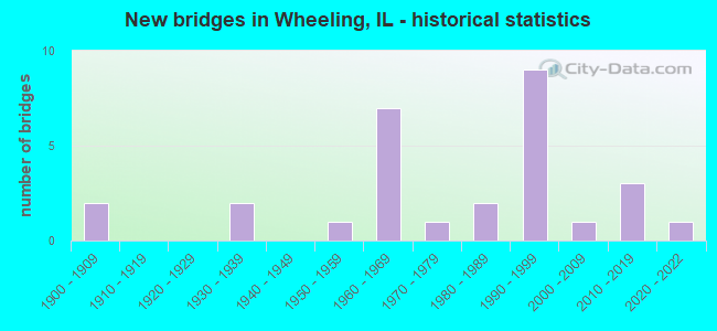
- New bridges - historical statistics
- 21900-1909
- 21930-1939
- 11950-1959
- 71960-1969
- 11970-1979
- 21980-1989
- 91990-1999
- 12000-2009
- 32010-2019
- 12020-2022
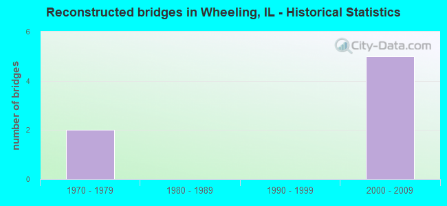
- Reconstructed bridges - Historical Statistics
- 21970-1979
- 01980-1989
- 01990-1999
- 52000-2009
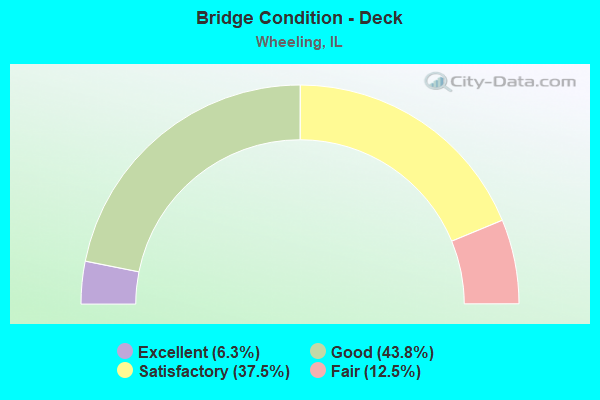
- Bridge Condition - Deck
- 6.3%Excellent
- 43.8%Good
- 37.5%Satisfactory
- 12.5%Fair
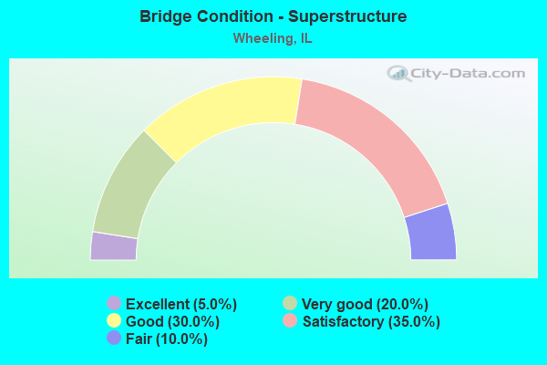
- Bridge Condition - Superstructure
- 5.0%Excellent
- 20.0%Very good
- 30.0%Good
- 35.0%Satisfactory
- 10.0%Fair
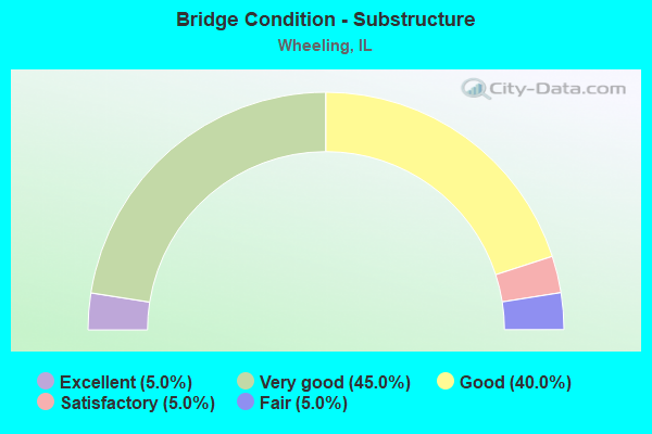
- Bridge Condition - Substructure
- 5.0%Excellent
- 45.0%Very good
- 40.0%Good
- 5.0%Satisfactory
- 5.0%Fair
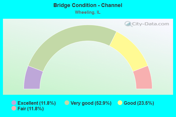
- Bridge Condition - Channel
- 11.8%Excellent
- 52.9%Very good
- 23.5%Good
- 11.8%Fair
Find on map >> Show street view
Structure Number: 160525, Location: 0.6 M W US 45 (Lat: 42.139514, Lng: -87.917747), Route carried "on" structure: State highway 68, Year Built: 1900, Year Reconstructed: 2011, Status: Open, Structure Length: 1.17m (3.84ft), Average Daily Traffic: 23,000 (year 2021), Truck Traffic: 3%, Average Future Daily Traffic: 28,428 (year 2032), Design Load: HS 20, Features Intersected: WHEELING DRN DTCH
Minimum Vertical Clearance: 30+ m (98+ ft), Kilometerpoint: 30.464, Lanes on structure: 4, Base Highway Network: Yes, Owner: State Highway Agency, Approaching Roadway Width: 18.9m (62.0ft), Material/Design: Concrete, Design/Construction: Frame, Number Of Spans In Main Unit: 1, Length of Maximum Span: 11.7m (38.4ft), Curb or Sidewalk Widths: Left: 2.9m (9.5ft), Right: 2.4m (7.9ft), Curb-To-Curb Width: 18.9m (62.0ft), Out-to-Out Width: 26.2m (86.0ft)
Condition: Superstructure: Satisfactory, Substructure: Very good, Channel: Good, Operating Rating: 54.1 metric tons, Method Used To Determine Operating Rating: Field evaluation and documented engineering judgment, Inventory Rating: 32.4 metric tons, Method Used To Determine Inventory Rating: Field evaluation and documented engineering judgment, Structural Evaluation: Equal to present minimum criteria, Deck Geometry: Equal to present minimum criteria, Waterway Adequacy: Equal to present desirable criteria, Approach Roadway Alignment: Equal to present desirable criteria, Designated Inspection Frequency: Every 24 months, Inspection Date: August 2020, Deck Structure Type: Other
Find on map >> Show street view
Structure Number: 160526, Location: 0.2 M E US 45 (Lat: 42.139772, Lng: -87.904308), Route carried "on" structure: State highway 68, Year Built: 1932, Year Reconstructed: 1982, Status: Open, Structure Length: 5.24m (17.19ft), Average Daily Traffic: 21,900 (year 2021), Truck Traffic: 2%, Average Future Daily Traffic: 32,239 (year 2032), Design Load: HS 20, Features Intersected: DES PLAINES RIVER
Minimum Vertical Clearance: 30+ m (98+ ft), Kilometerpoint: 31.558, Lanes on structure: 4, Base Highway Network: Yes, Owner: State Highway Agency, Approaching Roadway Width: 14.6m (47.9ft), Material/Design: Concrete, Design/Construction: Arch - Deck, Number Of Spans In Main Unit: 2, Length of Maximum Span: 21.9m (71.9ft), Curb or Sidewalk Widths: Left: 1.5m (4.9ft), Right: 1.5m (4.9ft), Curb-To-Curb Width: 15.8m (51.8ft), Out-to-Out Width: 19.5m (64.0ft)
Condition: Superstructure: Fair, Substructure: Fair, Channel: Good, Operating Rating: 43.1 metric tons, Method Used To Determine Operating Rating: Field evaluation and documented engineering judgment, Inventory Rating: 25.9 metric tons, Method Used To Determine Inventory Rating: Field evaluation and documented engineering judgment, Structural Evaluation: Somewhat better than minimum adequacy, Deck Geometry: Meets minimum limits, Waterway Adequacy: Equal to present desirable criteria, Approach Roadway Alignment: Equal to present desirable criteria, Length Of Structure Improvement: 5.24m (17.19ft), Designated Inspection Frequency: Every 24 months, Inspection Date: April 2021, Bridge Improvement Cost: $793,000, Roadway Improvement Cost: $79,000, Total Project Cost: $1,190,000, Deck Structure Type: Concrete Cast-file-Place, Wearing Surface/Protective System: Wearing Surface: Bituminous, Membrane: Built-up
Find on map >> Show street view
Structure Number: 160556, Location: 0.2 M NW IL 68 (Lat: 42.141908, Lng: -87.933608), Route carried "on" structure: Other road , Year Built: 1931, Year Reconstructed: 1984, Status: Open, Structure Length: 1.05m (3.44ft), Average Daily Traffic: 11,700 (year 2021), Truck Traffic: 2%, Average Future Daily Traffic: 13,184 (year 2032), Design Load: HS 20, Features Intersected: WHEELING DRN DTCH, Facility Carried by Structure: MCHENRY RD
Minimum Vertical Clearance: 30+ m (98+ ft), Kilometerpoint: 0.338, Lanes on structure: 2, Owner: State Highway Agency, Approaching Roadway Width: 12.2m (40.0ft), Material/Design: Concrete, Design/Construction: Slab, Number Of Spans In Main Unit: 1, Number Of Approach Spans: 1, Length of Maximum Span: 6.4m (21.0ft), Curb or Sidewalk Widths: Left: 1.5m (4.9ft), Right: 1.5m (4.9ft), Curb-To-Curb Width: 13.4m (44.0ft), Out-to-Out Width: 14.1m (46.3ft)
Condition: Deck: Fair, Superstructure: Fair, Substructure: Good, Channel: Good, Operating Rating: 61.6 metric tons, Method Used To Determine Operating Rating: Load Factor (LF) rating reported by rating factor (RF) method using MS18 loading, Inventory Rating: 36.9 metric tons, Method Used To Determine Inventory Rating: Load Factor (LF) rating reported by rating factor (RF) method using MS18 loading, Structural Evaluation: Somewhat better than minimum adequacy, Deck Geometry: Equal to present minimum criteria, Waterway Adequacy: Equal to present desirable criteria, Approach Roadway Alignment: Equal to present desirable criteria, Designated Inspection Frequency: Every 24 months, Inspection Date: September 2021, Deck Structure Type: Concrete Cast-file-Place, Wearing Surface/Protective System: Wearing Surface: Latex Concrete, Deck Protection: Epoxy Coated Reinforcing
Find on map >> Show street view
Structure Number: 16068, Location: 2.2 M S IL 68 (Lat: 42.109481, Lng: -87.907661), Route carried "on" structure: Other road , Year Built: 1963, Year Reconstructed: 2012, Status: Open, Structure Length: 2.15m (7.05ft), Average Daily Traffic: 14,100 (year 2018), Truck Traffic: 5%, Average Future Daily Traffic: 17,613 (year 2032), Design Load: HS 25 or greater, Features Intersected: PALATINE RD, Facility Carried by Structure: WOLF RD
Minimum Vertical Clearance: 30+ m (98+ ft), Kilometerpoint: 4.908, Lanes on structure: 4, Lanes under structure: 4, Base Highway Network: Yes, Owner: State Highway Agency, Approaching Roadway Width: 17.1m (56.1ft), Material/Design: Steel, Design/Construction: Stringer/Multi-beam, Number Of Spans In Main Unit: 1, Length of Maximum Span: 19.5m (64.0ft), Curb or Sidewalk Widths: Left: 2.1m (6.9ft), Right: 2.1m (6.9ft), Curb-To-Curb Width: 17.1m (56.1ft), Out-to-Out Width: 21.9m (71.9ft)
Condition: Deck: Good, Superstructure: Good, Substructure: Good, Operating Rating: 70.3 metric tons, Method Used To Determine Operating Rating: Load Factor (LF) rating reported by rating factor (RF) method using MS18 loading, Inventory Rating: 42.1 metric tons, Method Used To Determine Inventory Rating: Load Factor (LF) rating reported by rating factor (RF) method using MS18 loading, Structural Evaluation: Better than present minimum criteria, Deck Geometry: Somewhat better than minimum adequacy, Underclear: High priority of replacement, Approach Roadway Alignment: Equal to present minimum criteria, Length Of Structure Improvement: 2.74m (8.99ft), Designated Inspection Frequency: Every 48 months, Inspection Date: October 2019, Bridge Improvement Cost: $465,000, Roadway Improvement Cost: $47,000, Total Project Cost: $698,000, Deck Structure Type: Concrete Cast-file-Place, Wearing Surface/Protective System: Deck Protection: Epoxy Coated Reinforcing
Find on map >> Show street view
Structure Number: 16221, Location: 300' S OF LAKE COOK (Lat: 42.152289, Lng: -87.914603), Route carried "on" structure: US 45, Year Built: 1993, Status: Open, Structure Length: 0.71m (2.33ft), Average Daily Traffic: 27,300 (year 2021), Truck Traffic: 4%, Average Future Daily Traffic: 29,046 (year 2032), Design Load: HS 20, Features Intersected: DITCH
Minimum Vertical Clearance: 30+ m (98+ ft), Kilometerpoint: 642.465, Lanes on structure: 6, Base Highway Network: Yes, Owner: State Highway Agency, Approaching Roadway Width: 32.9m (107.9ft), Skew: 21 degrees, Material/Design: Concrete continuous, Design/Construction: Culvert, Number Of Spans In Main Unit: 3, Length of Maximum Span: 2.3m (7.5ft)
Condition: Channel: Very good, Culverts: Good, Operating Rating: 64.5 metric tons, Method Used To Determine Operating Rating: Load Factor (LF) rating reported by rating factor (RF) method using MS18 loading, Inventory Rating: 38.6 metric tons, Method Used To Determine Inventory Rating: Load Factor (LF) rating reported by rating factor (RF) method using MS18 loading, Structural Evaluation: Better than present minimum criteria, Waterway Adequacy: Equal to present desirable criteria, Approach Roadway Alignment: Equal to present desirable criteria, Designated Inspection Frequency: Every 48 months, Inspection Date: January 2019
Find on map >> Show street view
Structure Number: 162529, Location: 1.3 M W OF US 45 (Lat: 42.109736, Lng: -87.915108), Route carried "on" structure: Other road , Year Built: 1963, Year Reconstructed: 2009, Status: Open, Structure Length: 2.12m (6.96ft), Average Daily Traffic: 2,900 (year 2018), Truck Traffic: 9%, Average Future Daily Traffic: 1,000 (year 2032), Design Load: HS 20, Features Intersected: PALATINE ROAD, Facility Carried by Structure: E FRONT RD
Minimum Vertical Clearance: 30+ m (98+ ft), Kilometerpoint: 0.612, Lanes on structure: 2, Lanes under structure: 4, Owner: State Highway Agency, Approaching Roadway Width: 11.0m (36.1ft), Material/Design: Prestressed concrete, Design/Construction: Box Beam or Girders - Multiple, Number Of Spans In Main Unit: 1, Length of Maximum Span: 20.0m (65.6ft), Curb or Sidewalk Widths: Left: 0.0m, Right: 1.5m (4.9ft), Curb-To-Curb Width: 9.8m (32.2ft), Out-to-Out Width: 12.1m (39.7ft)
Condition: Deck: Good, Superstructure: Very good, Substructure: Satisfactory, Operating Rating: 74.5 metric tons, Method Used To Determine Operating Rating: Load Factor (LF) rating reported by rating factor (RF) method using MS18 loading, Inventory Rating: 44.7 metric tons, Method Used To Determine Inventory Rating: Load Factor (LF) rating reported by rating factor (RF) method using MS18 loading, Structural Evaluation: Equal to present minimum criteria, Deck Geometry: Meets minimum limits, Underclear: High priority of corrective action, Approach Roadway Alignment: Equal to present minimum criteria, Length Of Structure Improvement: 2.04m (6.69ft), Designated Inspection Frequency: Every 24 months, Inspection Date: May 2021, Bridge Improvement Cost: $196,000, Roadway Improvement Cost: $20,000, Total Project Cost: $294,000, Deck Structure Type: Concrete Cast-file-Place, Wearing Surface/Protective System: Wearing Surface: Integral Concrete, Deck Protection: Epoxy Coated Reinforcing
Find on map >> Show street view
Structure Number: 16253, Location: 1.3 M W OF US 45 (Lat: 42.109850, Lng: -87.915822), Route carried "on" structure: Other road , Year Built: 1963, Year Reconstructed: 2009, Status: Open, Structure Length: 2.12m (6.96ft), Average Daily Traffic: 850 (year 2018), Truck Traffic: 2%, Average Future Daily Traffic: 2,000 (year 2032), Design Load: HS 20, Features Intersected: PALATINE ROAD, Facility Carried by Structure: W FRONT RD
Minimum Vertical Clearance: 30+ m (98+ ft), Kilometerpoint: 0.032, Lanes on structure: 2, Lanes under structure: 4, Owner: State Highway Agency, Approaching Roadway Width: 9.8m (32.2ft), Material/Design: Prestressed concrete, Design/Construction: Box Beam or Girders - Multiple, Number Of Spans In Main Unit: 1, Length of Maximum Span: 20.0m (65.6ft), Curb or Sidewalk Widths: Left: 1.5m (4.9ft), Right: 0.6m (2.0ft), Curb-To-Curb Width: 7.3m (24.0ft), Out-to-Out Width: 14.8m (48.6ft)
Condition: Deck: Good, Superstructure: Good, Substructure: Good, Operating Rating: 79.4 metric tons, Method Used To Determine Operating Rating: Load Factor (LF) rating reported by rating factor (RF) method using MS18 loading, Inventory Rating: 47.6 metric tons, Method Used To Determine Inventory Rating: Load Factor (LF) rating reported by rating factor (RF) method using MS18 loading, Structural Evaluation: Better than present minimum criteria, Deck Geometry: High priority of replacement, Underclear: High priority of corrective action, Approach Roadway Alignment: Equal to present minimum criteria, Length Of Structure Improvement: 2.04m (6.69ft), Designated Inspection Frequency: Every 48 months, Inspection Date: May 2021, Bridge Improvement Cost: $196,000, Roadway Improvement Cost: $20,000, Total Project Cost: $294,000, Deck Structure Type: Concrete Cast-file-Place, Wearing Surface/Protective System: Wearing Surface: Integral Concrete, Deck Protection: Epoxy Coated Reinforcing
Find on map >> Show street view
Structure Number: 162634, Location: 1.2M S IL-68 (Lat: 42.125939, Lng: -87.908711), Route carried "on" structure: Other road , Year Built: 1993, Status: Open, Structure Length: 3.22m (10.56ft), Average Daily Traffic: 13,300 (year 2018), Truck Traffic: 3%, Average Future Daily Traffic: 13,699 (year 2032), Design Load: HS 20, Features Intersected: Buffalo Creek, Facility Carried by Structure: WOLF ROAD
Minimum Vertical Clearance: 30+ m (98+ ft), Kilometerpoint: 3.074, Lanes on structure: 4, Base Highway Network: Yes, Owner: City or Municipal Highway Agency, Approaching Roadway Width: 20.7m (67.9ft), Skew: 32 degrees, Material/Design: Steel continuous, Design/Construction: Stringer/Multi-beam, Number Of Spans In Main Unit: 3, Length of Maximum Span: 12.4m (40.7ft), Curb or Sidewalk Widths: Left: 1.5m (4.9ft), Right: 1.5m (4.9ft), Curb-To-Curb Width: 8.2m (26.9ft), Out-to-Out Width: 24.4m (80.1ft)
Condition: Deck: Good, Superstructure: Good, Substructure: Very good, Channel: Very good, Operating Rating: 44.1 metric tons, Method Used To Determine Operating Rating: Load Factor (LF) rating reported by rating factor (RF) method using MS18 loading, Inventory Rating: 32.4 metric tons, Method Used To Determine Inventory Rating: Load Factor (LF) rating reported by rating factor (RF) method using MS18 loading, Structural Evaluation: Better than present minimum criteria, Deck Geometry: High priority of replacement, Waterway Adequacy: Equal to present desirable criteria, Approach Roadway Alignment: Equal to present desirable criteria, Designated Inspection Frequency: Every 48 months, Inspection Date: July 2020, Deck Structure Type: Concrete Cast-file-Place, Wearing Surface/Protective System: Deck Protection: Epoxy Coated Reinforcing
Find on map >> Show street view
Structure Number: 162668, Location: 0.4 M N PALATINE RD (Lat: 42.121911, Lng: -87.896031), Route carried "on" structure: US 45, Year Built: 1996, Status: Open, Structure Length: 2.96m (9.71ft), Average Daily Traffic: 27,100 (year 2021), Truck Traffic: 6%, Average Future Daily Traffic: 29,046 (year 2032), Design Load: HS 20+Mod, Features Intersected: WHEELING DRAIN DITCH
Minimum Vertical Clearance: 30.18m (99.02ft), Kilometerpoint: 638.715, Lanes on structure: 4, Base Highway Network: Yes, Owner: State Highway Agency, Approaching Roadway Width: 17.1m (56.1ft), Skew: 33 degrees, Material/Design: Concrete continuous, Design/Construction: Slab, Number Of Spans In Main Unit: 3, Length of Maximum Span: 10.5m (34.4ft), Curb or Sidewalk Widths: Left: 1.8m (5.9ft), Right: 1.8m (5.9ft), Curb-To-Curb Width: 16.5m (54.1ft), Out-to-Out Width: 25.0m (82.0ft)
Condition: Deck: Satisfactory, Superstructure: Satisfactory, Substructure: Very good, Channel: Good, Operating Rating: 74.2 metric tons, Method Used To Determine Operating Rating: Load Factor (LF) rating reported by rating factor (RF) method using MS18 loading, Inventory Rating: 44.7 metric tons, Method Used To Determine Inventory Rating: Load Factor (LF) rating reported by rating factor (RF) method using MS18 loading, Structural Evaluation: Equal to present minimum criteria, Deck Geometry: Meets minimum limits, Waterway Adequacy: Equal to present desirable criteria, Approach Roadway Alignment: Equal to present desirable criteria, Designated Inspection Frequency: Every 24 months, Inspection Date: August 2020, Deck Structure Type: Other, Wearing Surface/Protective System: Deck Protection: Epoxy Coated Reinforcing
Find on map >> Show street view
Structure Number: 162774, Location: 0.3 M N IL 68 (Lat: 42.142544, Lng: -87.936594), Route carried "on" structure: State highway 83, Year Built: 2003, Status: Open, Structure Length: 1.95m (6.40ft), Average Daily Traffic: 13,200 (year 2021), Truck Traffic: 3%, Average Future Daily Traffic: 13,081 (year 2032), Features Intersected: WHEELING DRN DITCH
Minimum Vertical Clearance: 30+ m (98+ ft), Kilometerpoint: 102.995, Lanes on structure: 4, Base Highway Network: Yes, Owner: State Highway Agency, Approaching Roadway Width: 20.7m (67.9ft), Material/Design: Concrete continuous, Design/Construction: Slab, Number Of Spans In Main Unit: 3, Length of Maximum Span: 6.2m (20.3ft), Curb-To-Curb Width: 20.7m (67.9ft), Out-to-Out Width: 24.4m (80.1ft)
Condition: Deck: Satisfactory, Superstructure: Good, Substructure: Good, Channel: Very good, Operating Rating: 66.7 metric tons, Method Used To Determine Operating Rating: Load Factor (LF) rating reported by rating factor (RF) method using MS18 loading, Inventory Rating: 40.2 metric tons, Method Used To Determine Inventory Rating: Load Factor (LF) rating reported by rating factor (RF) method using MS18 loading, Structural Evaluation: Better than present minimum criteria, Deck Geometry: Superior to present desirable criteria, Waterway Adequacy: Equal to present desirable criteria, Approach Roadway Alignment: Equal to present desirable criteria, Designated Inspection Frequency: Every 48 months, Inspection Date: October 2019, Deck Structure Type: Concrete Cast-file-Place, Wearing Surface/Protective System: Deck Protection: Epoxy Coated Reinforcing
Find on map >> Show street view
Structure Number: 163104, Location: 0.1 E BUFFALO GR P25 (Lat: 42.151836, Lng: -87.957428), Route carried "on" structure: County highway , Year Built: 1955, Status: Closed, Structure Length: 1.37m (4.49ft), Average Daily Traffic: 5,300 (year 2018), Truck Traffic: 3%, Average Future Daily Traffic: 5,459 (year 2032), Design Load: H 20, Features Intersected: BUFFALO CREEK, Facility Carried by Structure: APTAKISIC RD
Minimum Vertical Clearance: 30+ m (98+ ft), Kilometerpoint: 0.241, Lanes on structure: 2, Owner: County Highway Agency, Approaching Roadway Width: 12.2m (40.0ft), Skew: 1 degrees, Material/Design: Concrete, Design/Construction: Culvert, Number Of Spans In Main Unit: 3, Length of Maximum Span: 4.0m (13.1ft), Curb-To-Curb Width: 11.6m (38.1ft), Out-to-Out Width: 12.0m (39.4ft)
Condition: Channel: Fair, Culverts: Good, Operating Rating: 32.4 metric tons, Method Used To Determine Operating Rating: Field evaluation and documented engineering judgment, Inventory Rating: 17.5 metric tons, Method Used To Determine Inventory Rating: Field evaluation and documented engineering judgment, Structural Evaluation: Meets minimum limits, Deck Geometry: Somewhat better than minimum adequacy, Waterway Adequacy: Equal to present minimum criteria, Approach Roadway Alignment: Better than present minimum criteria, Designated Inspection Frequency: Every 24 months, Inspection Date: July 2021, Deck Structure Type: Concrete Cast-file-Place, Wearing Surface/Protective System: Wearing Surface: Bituminous
Find on map >> Show street view
Structure Number: 163111, Location: 157 Ft W IL Rt 83 (Lat: 42.151836, Lng: -87.957428), Route carried "on" structure: County highway , Year Built: 2021, Status: Open, Structure Length: 2.06m (6.76ft), Average Daily Traffic: 5,300 (year 2018), Truck Traffic: 3%, Average Future Daily Traffic: 6,310 (year 2040), Design Load: HS 25 or greater, Features Intersected: Bufalo Creek, Facility Carried by Structure: Weiland Road
Minimum Vertical Clearance: 30+ m (98+ ft), Kilometerpoint: 0.241, Lanes on structure: 6, Owner: County Highway Agency, Approaching Roadway Width: 25.0m (82.0ft), Skew: 30 degrees, Material/Design: Prestressed concrete, Design/Construction: Stringer/Multi-beam, Number Of Spans In Main Unit: 1, Length of Maximum Span: 0.0m, Curb or Sidewalk Widths: Left: 4.9m (16.1ft), Right: 0.0m, Curb-To-Curb Width: 25.0m (82.0ft), Out-to-Out Width: 31.3m (102.7ft)
Condition: Deck: Excellent, Superstructure: Excellent, Substructure: Excellent, Channel: Excellent, Deck Geometry: Somewhat better than minimum adequacy, Waterway Adequacy: Equal to present desirable criteria, Approach Roadway Alignment: Equal to present desirable criteria, Designated Inspection Frequency: Every 24 months, Inspection Date: October 2021, Deck Structure Type: Concrete Cast-file-Place, Wearing Surface/Protective System: Deck Protection: Epoxy Coated Reinforcing
Find on map >> Show street view
Structure Number: 163201, Location: 1 M W MILW AV P25 (Lat: 42.153006, Lng: -87.933986), Route carried "on" structure: Other road , Year Built: 1979, Status: Open, Structure Length: 4.83m (15.85ft), Average Daily Traffic: 36,300 (year 2018), Truck Traffic: 4%, Average Future Daily Traffic: 40,170 (year 2032), Design Load: HS 20, Features Intersected: W.C.RR.(SOO LINE), Facility Carried by Structure: LAKE COOK RD
Minimum Vertical Clearance: 30+ m (98+ ft), Kilometerpoint: 8.771, Lanes on structure: 6, Base Highway Network: Yes, Owner: County Highway Agency, Approaching Roadway Width: 24.4m (80.1ft), Skew: 31 degrees, Material/Design: Steel continuous, Design/Construction: Stringer/Multi-beam, Number Of Spans In Main Unit: 3, Length of Maximum Span: 18.3m (60.0ft), Curb or Sidewalk Widths: Left: 5.5m (18.0ft), Right: 1.5m (4.9ft), Curb-To-Curb Width: 23.5m (77.1ft), Out-to-Out Width: 32.0m (105.0ft)
Condition: Deck: Fair, Superstructure: Satisfactory, Substructure: Good, Operating Rating: 71.3 metric tons, Method Used To Determine Operating Rating: Load Factor (LF) rating reported by rating factor (RF) method using MS18 loading, Inventory Rating: 42.8 metric tons, Method Used To Determine Inventory Rating: Load Factor (LF) rating reported by rating factor (RF) method using MS18 loading, Structural Evaluation: Equal to present minimum criteria, Deck Geometry: Somewhat better than minimum adequacy, Underclear: Superior to present desirable criteria, Approach Roadway Alignment: Equal to present desirable criteria, Length Of Structure Improvement: 4.94m (16.21ft), Designated Inspection Frequency: Every 24 months, Inspection Date: January 2022, Bridge Improvement Cost: $181,000, Roadway Improvement Cost: $18,000, Total Project Cost: $217,000, Deck Structure Type: Concrete Cast-file-Place, Wearing Surface/Protective System: Deck Protection: Epoxy Coated Reinforcing
Find on map >> Show street view
Structure Number: 163226, Location: 0.05M.W.WHEELING RD. (Lat: 42.124256, Lng: -87.929308), Route carried "on" structure: Other road , Year Built: 1987, Status: Open, Structure Length: 15.33m (50.30ft), Average Daily Traffic: 17,000 (year 2018), Truck Traffic: 6%, Average Future Daily Traffic: 18,643 (year 2032), Design Load: HS 20, Features Intersected: ECHO LAKE, Facility Carried by Structure: HINTZ RD.
Minimum Vertical Clearance: 30+ m (98+ ft), Kilometerpoint: 5.681, Lanes on structure: 4, Owner: County Highway Agency, Approaching Roadway Width: 19.5m (64.0ft), Skew: 20 degrees, Material/Design: Concrete, Design/Construction: Slab, Number Of Spans In Main Unit: 20, Length of Maximum Span: 7.6m (24.9ft), Curb-To-Curb Width: 20.7m (67.9ft), Out-to-Out Width: 21.7m (71.2ft)
Condition: Deck: Satisfactory, Superstructure: Satisfactory, Substructure: Very good, Channel: Very good, Operating Rating: 44.4 metric tons, Method Used To Determine Operating Rating: Assigned rating based on Load Factor Design (LFD) reported by rating factor (RF) using MS18 loading, Inventory Rating: 32.4 metric tons, Method Used To Determine Inventory Rating: Assigned rating based on Load Factor Design (LFD) reported by rating factor (RF) using MS18 loading, Structural Evaluation: Equal to present minimum criteria, Deck Geometry: Superior to present desirable criteria, Waterway Adequacy: Equal to present desirable criteria, Approach Roadway Alignment: Equal to present desirable criteria, Designated Inspection Frequency: Every 24 months, Inspection Date: December 2020, Deck Structure Type: Concrete Cast-file-Place, Wearing Surface/Protective System: Deck Protection: Epoxy Coated Reinforcing
Find on map >> Show street view
Structure Number: 163229, Location: 0.1M E WOLF ROAD (Lat: 42.125083, Lng: -87.907506), Route carried "on" structure: Other road , Year Built: 1994, Status: Open, Structure Length: 3.94m (12.93ft), Average Daily Traffic: 10,900 (year 2018), Truck Traffic: 8%, Average Future Daily Traffic: 10,403 (year 2032), Design Load: HS 20, Features Intersected: WHEELING DRN DITCH, Facility Carried by Structure: HINTZ ROAD
Minimum Vertical Clearance: 30+ m (98+ ft), Kilometerpoint: 7.644, Lanes on structure: 4, Owner: County Highway Agency, Approaching Roadway Width: 16.5m (54.1ft), Skew: 34 degrees, Material/Design: Steel continuous, Design/Construction: Stringer/Multi-beam, Number Of Spans In Main Unit: 3, Number Of Approach Spans: 2, Length of Maximum Span: 14.4m (47.2ft), Curb or Sidewalk Widths: Left: 1.5m (4.9ft), Right: 1.5m (4.9ft), Curb-To-Curb Width: 16.5m (54.1ft), Out-to-Out Width: 21.9m (71.9ft)
Condition: Deck: Good, Superstructure: Satisfactory, Substructure: Very good, Channel: Very good, Operating Rating: 44.1 metric tons, Method Used To Determine Operating Rating: Assigned rating based on Load Factor Design (LFD) reported by rating factor (RF) using MS18 loading, Inventory Rating: 32.4 metric tons, Method Used To Determine Inventory Rating: Assigned rating based on Load Factor Design (LFD) reported by rating factor (RF) using MS18 loading, Structural Evaluation: Equal to present minimum criteria, Deck Geometry: Meets minimum limits, Waterway Adequacy: Equal to present desirable criteria, Approach Roadway Alignment: Equal to present desirable criteria, Designated Inspection Frequency: Every 24 months, Inspection Date: May 2021, Deck Structure Type: Concrete Cast-file-Place, Wearing Surface/Protective System: Deck Protection: Epoxy Coated Reinforcing
Find on map >> Show street view
Structure Number: 163257, Location: 2.1 M W I-94 (Lat: 42.153108, Lng: -87.915503), Route carried "on" structure: Other road , Year Built: 1995, Status: Open, Structure Length: 7.97m (26.15ft), Average Daily Traffic: 43,300 (year 2018), Truck Traffic: 4%, Average Future Daily Traffic: 40,170 (year 2032), Design Load: HS 20, Features Intersected: IL 21 (MILWAUKEE), Facility Carried by Structure: LAKE COOK RD
Minimum Vertical Clearance: 30+ m (98+ ft), Kilometerpoint: 10.332, Lanes on structure: 6, Lanes under structure: 4, Base Highway Network: Yes, Owner: State Highway Agency, Approaching Roadway Width: 21.9m (71.9ft), Material/Design: Steel continuous, Design/Construction: Stringer/Multi-beam, Number Of Spans In Main Unit: 2, Number Of Approach Spans: 2, Length of Maximum Span: 39.0m (128.0ft), Curb-To-Curb Width: 21.9m (71.9ft), Out-to-Out Width: 29.4m (96.5ft)
Condition: Deck: Good, Superstructure: Good, Substructure: Good, Operating Rating: 44.1 metric tons, Method Used To Determine Operating Rating: Assigned rating based on Load Factor Design (LFD) reported by rating factor (RF) using MS18 loading, Inventory Rating: 32.4 metric tons, Method Used To Determine Inventory Rating: Assigned rating based on Load Factor Design (LFD) reported by rating factor (RF) using MS18 loading, Structural Evaluation: Better than present minimum criteria, Deck Geometry: High priority of corrective action, Underclear: Meets minimum limits, Approach Roadway Alignment: Equal to present desirable criteria, Length Of Structure Improvement: 10.88m (35.70ft), Designated Inspection Frequency: Every 24 months, Inspection Date: September 2020, Bridge Improvement Cost: $3,746,000, Roadway Improvement Cost: $375,000, Total Project Cost: $5,619,000, Deck Structure Type: Concrete Cast-file-Place, Wearing Surface/Protective System: Deck Protection: Epoxy Coated Reinforcing
Find on map >> Show street view
Structure Number: 163258, Location: 0.2 M E OF US-45 (Lat: 42.153081, Lng: -87.911886), Route carried "on" structure: Other road , Year Built: 1994, Status: Open, Structure Length: 5.92m (19.42ft), Average Daily Traffic: 45,800 (year 2018), Truck Traffic: 3%, Average Future Daily Traffic: 48,925 (year 2032), Design Load: HS 20, Features Intersected: DES PLAINES RIVER, Facility Carried by Structure: LAKE-COOK ROAD
Minimum Vertical Clearance: 30+ m (98+ ft), Kilometerpoint: 10.718, Lanes on structure: 6, Base Highway Network: Yes, Owner: County Highway Agency, Approaching Roadway Width: 21.9m (71.9ft), Skew: 10 degrees, Material/Design: Prestressed concrete continuous, Design/Construction: Stringer/Multi-beam, Number Of Spans In Main Unit: 2, Number Of Approach Spans: 2, Length of Maximum Span: 29.3m (96.1ft), Curb or Sidewalk Widths: Left: 1.5m (4.9ft), Right: 1.5m (4.9ft), Curb-To-Curb Width: 41.7m (136.8ft), Out-to-Out Width: 46.3m (151.9ft)
Condition: Deck: Satisfactory, Superstructure: Very good, Substructure: Good, Channel: Excellent, Operating Rating: 53.5 metric tons, Method Used To Determine Operating Rating: Load Factor (LF) rating reported by rating factor (RF) method using MS18 loading, Inventory Rating: 32.1 metric tons, Method Used To Determine Inventory Rating: Load Factor (LF) rating reported by rating factor (RF) method using MS18 loading, Structural Evaluation: Better than present minimum criteria, Deck Geometry: Superior to present desirable criteria, Waterway Adequacy: Superior to present desirable criteria, Approach Roadway Alignment: Equal to present desirable criteria, Designated Inspection Frequency: Every 24 months, Underwater Inspection Frequency: Every 60 months, Inspection Date: July 2020, Underwater Inspection Date: August 2020, Deck Structure Type: Concrete Precast Panels, Wearing Surface/Protective System: Deck Protection: Epoxy Coated Reinforcing
Find on map >> Show street view
Structure Number: 168212, Location: 0.11M.N. IL-68 (Lat: 42.140853, Lng: -87.925828), Route carried "on" structure: City street , Year Built: 1988, Year Reconstructed: 2013, Status: Open, Structure Length: 2.73m (8.96ft), Average Daily Traffic: 8,100 (year 2018), Truck Traffic: 9%, Average Future Daily Traffic: 4,232 (year 2032), Design Load: HS 20, Features Intersected: BUFFALO CREEK, Facility Carried by Structure: NORTHGATE PKWY.
Minimum Vertical Clearance: 30+ m (98+ ft), Kilometerpoint: 1.432, Lanes on structure: 3, Owner: City or Municipal Highway Agency, Approaching Roadway Width: 12.6m (41.3ft), Material/Design: Concrete, Design/Construction: Slab, Number Of Spans In Main Unit: 3, Length of Maximum Span: 10.2m (33.5ft), Curb or Sidewalk Widths: Left: 1.5m (4.9ft), Right: 2.0m (6.6ft), Curb-To-Curb Width: 12.6m (41.3ft), Out-to-Out Width: 16.9m (55.4ft)
Condition: Deck: Satisfactory, Superstructure: Satisfactory, Substructure: Good, Channel: Fair, Operating Rating: 44.4 metric tons, Method Used To Determine Operating Rating: Assigned rating based on Load Factor Design (LFD) reported by rating factor (RF) using MS18 loading, Inventory Rating: 32.4 metric tons, Method Used To Determine Inventory Rating: Assigned rating based on Load Factor Design (LFD) reported by rating factor (RF) using MS18 loading, Structural Evaluation: Equal to present minimum criteria, Deck Geometry: Meets minimum limits, Waterway Adequacy: Superior to present desirable criteria, Approach Roadway Alignment: Equal to present desirable criteria, Designated Inspection Frequency: Every 24 months, Inspection Date: March 2021, Deck Structure Type: Concrete Cast-file-Place
Find on map >> Show street view
Structure Number: 168213, Location: 0.4 MI E WHEELING RD (Lat: 42.107600, Lng: -87.920222), Route carried "on" structure: City street , Year Built: 1998, Status: Open, Structure Length: 1.33m (4.36ft), Average Daily Traffic: 700 (year 2018), Truck Traffic: 7%, Average Future Daily Traffic: 164 (year 2032), Design Load: HS 20, Features Intersected: MCDONALD CREEK, Facility Carried by Structure: GENEVA DR
Minimum Vertical Clearance: 30+ m (98+ ft), Kilometerpoint: 0.402, Lanes on structure: 2, Owner: City or Municipal Highway Agency, Approaching Roadway Width: 8.8m (28.9ft), Material/Design: Concrete, Design/Construction: Frame, Number Of Spans In Main Unit: 1, Length of Maximum Span: 12.8m (42.0ft), Curb or Sidewalk Widths: Left: 1.6m (5.2ft), Right: 1.6m (5.2ft), Curb-To-Curb Width: 8.8m (28.9ft), Out-to-Out Width: 13.0m (42.7ft)
Condition: Superstructure: Very good, Substructure: Very good, Channel: Very good, Operating Rating: 44.1 metric tons, Method Used To Determine Operating Rating: Assigned rating based on Load Factor Design (LFD) reported by rating factor (RF) using MS18 loading, Inventory Rating: 32.4 metric tons, Method Used To Determine Inventory Rating: Assigned rating based on Load Factor Design (LFD) reported by rating factor (RF) using MS18 loading, Structural Evaluation: Equal to present desirable criteria, Deck Geometry: Somewhat better than minimum adequacy, Waterway Adequacy: Equal to present desirable criteria, Approach Roadway Alignment: Equal to present desirable criteria, Designated Inspection Frequency: Every 48 months, Inspection Date: March 2018
Find on map >> Show street view
Structure Number: 168214, Location: 0.4 MI S PALATINE RD (Lat: 42.103800, Lng: -87.915883), Route carried "on" structure: City street , Year Built: 1998, Status: Open, Structure Length: 1.33m (4.36ft), Average Daily Traffic: 1,750 (year 2018), Truck Traffic: 7%, Average Future Daily Traffic: 2,833 (year 2032), Design Load: HS 20, Features Intersected: MCDONALD CREEK, Facility Carried by Structure: WILLOW RD
Minimum Vertical Clearance: 30+ m (98+ ft), Kilometerpoint: 0.483, Lanes on structure: 2, Owner: City or Municipal Highway Agency, Approaching Roadway Width: 8.8m (28.9ft), Material/Design: Concrete, Design/Construction: Frame, Number Of Spans In Main Unit: 1, Length of Maximum Span: 12.8m (42.0ft), Curb or Sidewalk Widths: Left: 2.3m (7.5ft), Right: 0.0m, Curb-To-Curb Width: 8.8m (28.9ft), Out-to-Out Width: 19.1m (62.7ft)
Condition: Superstructure: Very good, Substructure: Very good, Channel: Very good, Operating Rating: 44.1 metric tons, Method Used To Determine Operating Rating: Assigned rating based on Load Factor Design (LFD) reported by rating factor (RF) using MS18 loading, Inventory Rating: 32.4 metric tons, Method Used To Determine Inventory Rating: Assigned rating based on Load Factor Design (LFD) reported by rating factor (RF) using MS18 loading, Structural Evaluation: Equal to present desirable criteria, Deck Geometry: Somewhat better than minimum adequacy, Waterway Adequacy: Equal to present desirable criteria, Approach Roadway Alignment: Equal to present desirable criteria, Designated Inspection Frequency: Every 48 months, Inspection Date: March 2018
Find on map >> Show street view
Structure Number: 168215, Location: 0.8 M W WOLF RD (Lat: 42.133189, Lng: -87.915086), Route carried "on" structure: City street , Year Built: 2014, Status: Open, Structure Length: 1.35m (4.43ft), Average Daily Traffic: 1,000 (year 2018), Truck Traffic: 6%, Average Future Daily Traffic: 360 (year 2037), Design Load: HS 25 or greater, Features Intersected: BUFFALO CREEK, Facility Carried by Structure: JEFFERY AVENUE
Minimum Vertical Clearance: 30+ m (98+ ft), Kilometerpoint: 0.531, Lanes on structure: 2, Owner: City or Municipal Highway Agency, Approaching Roadway Width: 8.5m (27.9ft), Skew: 2 degrees, Material/Design: Concrete, Design/Construction: Slab, Number Of Spans In Main Unit: 1, Length of Maximum Span: 12.8m (42.0ft), Curb or Sidewalk Widths: Left: 1.5m (4.9ft), Right: 1.5m (4.9ft), Curb-To-Curb Width: 8.5m (27.9ft), Out-to-Out Width: 12.2m (40.0ft)
Condition: Deck: Satisfactory, Superstructure: Satisfactory, Substructure: Very good, Channel: Very good, Operating Rating: 42.1 metric tons, Method Used To Determine Operating Rating: Assigned ratings based on Load and Resistance Factor Design (LRFD) reported by rating factor (RF) using HL93 loadings, Inventory Rating: 32.4 metric tons, Method Used To Determine Inventory Rating: Assigned ratings based on Load and Resistance Factor Design (LRFD) reported by rating factor (RF) using HL93 loadings, Structural Evaluation: Equal to present minimum criteria, Deck Geometry: Somewhat better than minimum adequacy, Waterway Adequacy: Better than present minimum criteria, Approach Roadway Alignment: Equal to present desirable criteria, Designated Inspection Frequency: Every 24 months, Inspection Date: March 2021, Deck Structure Type: Concrete Cast-file-Place, Wearing Surface/Protective System: Deck Protection: Epoxy Coated Reinforcing
Find on map >> Show street view
Structure Number: 169005, Location: 0.8 MI W of Wolf Rd (Lat: 42.133722, Lng: -87.915753), Route carried "on" structure: City street , Year Built: 2013, Status: Open, Structure Length: 1.94m (6.36ft), Average Daily Traffic: 850 (year 2018), Truck Traffic: 1%, Average Future Daily Traffic: 10 (year 2032), Design Load: HS 25 or greater, Features Intersected: Buffalo Creek, Facility Carried by Structure: MS-9999 Wolf Rd Ac
Minimum Vertical Clearance: 30+ m (98+ ft), Kilometerpoint: 0.145, Lanes on structure: 2, Owner: Local Agency, Approaching Roadway Width: 8.1m (26.6ft), Skew: 3 degrees, Material/Design: Steel, Design/Construction: Stringer/Multi-beam, Number Of Spans In Main Unit: 1, Length of Maximum Span: 18.5m (60.7ft), Curb or Sidewalk Widths: Left: 0.0m, Right: 2.8m (9.2ft), Curb-To-Curb Width: 8.1m (26.6ft), Out-to-Out Width: 11.8m (38.7ft)
Condition: Deck: Good, Superstructure: Good, Substructure: Very good, Channel: Very good, Operating Rating: 42.1 metric tons, Method Used To Determine Operating Rating: Assigned ratings based on Load and Resistance Factor Design (LRFD) reported by rating factor (RF) using HL93 loadings, Inventory Rating: 32.4 metric tons, Method Used To Determine Inventory Rating: Assigned ratings based on Load and Resistance Factor Design (LRFD) reported by rating factor (RF) using HL93 loadings, Structural Evaluation: Better than present minimum criteria, Deck Geometry: Somewhat better than minimum adequacy, Waterway Adequacy: Superior to present desirable criteria, Approach Roadway Alignment: Equal to present desirable criteria, Designated Inspection Frequency: Every 48 months, Inspection Date: December 2021, Deck Structure Type: Concrete Cast-file-Place, Wearing Surface/Protective System: Deck Protection: Epoxy Coated Reinforcing
Find on map >> Show street view
Structure Number: 16068, Location: 2.2 M S IL 68 (Lat: 42.109481, Lng: -87.907661), Route carried "under" structure: Other road , Year Built: 1963, Structure Length: 0. m, Average Daily Traffic: 31,200 (year 2018), Truck Traffic: 5%, Features Intersected: PALATINE RD, Facility Carried by Structure: WOLF RD
Minimum Vertical Clearance: 4.42m (14.50ft), Kilometerpoint: 20.422, Lanes on structure: 4, Lanes under structure: 4, Material/Design: Steel, Design/Construction: Stringer/Multi-beam, Length of Maximum Span: 19.5m (64.0ft)
Find on map >> Show street view
Structure Number: 162025, Location: 1.3 M W US 45 (Lat: 42.109661, Lng: -87.915392), Route carried "under" structure: Other road , Year Built: 1963, Structure Length: 0. m, Average Daily Traffic: 34,200 (year 2018), Truck Traffic: 8%, Features Intersected: PALATINE RD, Facility Carried by Structure: RR - CN (West Trac
Minimum Vertical Clearance: 4.42m (14.50ft), Kilometerpoint: 19.730, Lanes under structure: 4, Material/Design: Steel, Design/Construction: Girder and Floorbeam System, Length of Maximum Span: 21.6m (70.9ft)
Find on map >> Show street view
Structure Number: 162529, Location: 1.3 M W OF US 45 (Lat: 42.109658, Lng: -87.915114), Route carried "under" structure: Other road , Year Built: 1963, Structure Length: 0. m, Average Daily Traffic: 34,200 (year 2018), Truck Traffic: 8%, Features Intersected: PALATINE ROAD, Facility Carried by Structure: E FRONT RD
Minimum Vertical Clearance: 4.62m (15.16ft), Kilometerpoint: 19.746, Lanes on structure: 2, Lanes under structure: 4, Material/Design: Prestressed concrete, Design/Construction: Box Beam or Girders - Multiple, Length of Maximum Span: 20.0m (65.6ft)
Find on map >> Show street view
Structure Number: 16253, Location: 1.3 M W OF US 45 (Lat: 42.109661, Lng: -87.915750), Route carried "under" structure: Other road , Year Built: 1963, Structure Length: 0. m, Average Daily Traffic: 34,200 (year 2018), Truck Traffic: 8%, Features Intersected: PALATINE ROAD, Facility Carried by Structure: W FRONT RD
Minimum Vertical Clearance: 4.50m (14.76ft), Kilometerpoint: 19.714, Lanes on structure: 2, Lanes under structure: 4, Material/Design: Prestressed concrete, Design/Construction: Box Beam or Girders - Multiple, Length of Maximum Span: 20.0m (65.6ft)
Find on map >> Show street view
Structure Number: 162694, Location: .38M W of Wolf Rd (Lat: 42.109658, Lng: -87.915114), Route carried "under" structure: Other road , Year Built: 2015, Structure Length: 0. m, Average Daily Traffic: 34,200 (year 2018), Truck Traffic: 8%, Features Intersected: PALATINE ROAD, Facility Carried by Structure: CN RR (east track)
Minimum Vertical Clearance: 4.37m (14.34ft), Kilometerpoint: 19.746, Lanes under structure: 4, Material/Design: Steel, Design/Construction: Truss - Deck, Length of Maximum Span: 19.5m (64.0ft)
Find on map >> Show street view
Structure Number: 163257, Location: 2.1 M W I-94 (Lat: 42.153103, Lng: -87.915014), Route carried "under" structure: US 45, Year Built: 1995, Structure Length: 0. m, Average Daily Traffic: 27,400 (year 2021), Truck Traffic: 6%, Features Intersected: IL 21 (MILWAUKEE), Facility Carried by Structure: LAKE COOK RD
Minimum Vertical Clearance: 5.03m (16.50ft), Kilometerpoint: 642.577, Lanes on structure: 6, Lanes under structure: 4, Material/Design: Steel continuous, Design/Construction: Stringer/Multi-beam, Length of Maximum Span: 39.0m (128.0ft)
Find on map >> Show street view
Structure Number: 167948, Location: .3M W OF IL83 (Lat: 42.139036, Lng: -87.942386), Route carried "under" structure: State highway 68, Year Built: 1900, Structure Length: 0. m, Average Daily Traffic: 27,900 (year 2021), Truck Traffic: 3%, Features Intersected: IL 68, Facility Carried by Structure: PED OVERPASS
Minimum Vertical Clearance: 4.32m (14.17ft), Kilometerpoint: 28.420, Lanes under structure: 4, Length of Maximum Span: 0.0m