Bridge Statistics for Wheatley, Arkansas (AR)
Condition, Traffic, Stress, Structural Evaluation, Project Costs
- National Bridge Inventory (NBI) Statistics
- 12Number of bridges
- 118ft / 35.8mTotal length
- $596,000Total costs
- 125,659Total average daily traffic
- 1,608Total average daily truck traffic
- National Bridge Inventory (NBI) Registered Bridges for Wheatley
- No street view available for this location
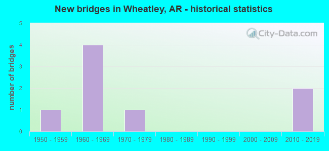
- New bridges - historical statistics
- 11950-1959
- 41960-1969
- 11970-1979
- 22010-2019


- Bridge Condition - Deck
- 14.3%Very good
- 28.6%Good
- 28.6%Fair
- 14.3%Poor
- 14.3%Imminent failure

- Bridge Condition - Superstructure
- 42.9%Good
- 14.3%Satisfactory
- 42.9%Fair

- Bridge Condition - Substructure
- 42.9%Good
- 28.6%Satisfactory
- 14.3%Fair
- 14.3%Imminent failure

- Bridge Condition - Channel
- 16.7%Very good
- 33.3%Good
- 50.0%Satisfactory
Find on map >> Show street view
Structure Number: 3767, Location: .07 Mi North Of Wheatley (Lat: 34.929839, Lng: -91.108208), Route carried "on" structure: State highway 78, Year Built: 1965, Status: Open, Structure Length: 6.71m (22.01ft), Average Daily Traffic: 410 (year 2019), Truck Traffic: 11%, Average Future Daily Traffic: 1,694 (year 2028), Design Load: H 20, Features Intersected: I-40/Sec-51/L-220.85
Minimum Vertical Clearance: 30+ m (98+ ft), Kilometerpoint: 8.208, Lanes on structure: 2, Lanes under structure: 4, Owner: State Highway Agency, Approaching Roadway Width: 6.9m (22.6ft), Material/Design: Steel, Design/Construction: Stringer/Multi-beam, Number Of Spans In Main Unit: 4, Length of Maximum Span: 20.4m (66.9ft), Curb or Sidewalk Widths: Left: 0.5m (1.6ft), Right: 0.5m (1.6ft), Curb-To-Curb Width: 7.9m (25.9ft), Out-to-Out Width: 8.8m (28.9ft)
Condition: Deck: Poor, Superstructure: Satisfactory, Substructure: Fair, Operating Rating: 45.4 metric tons, Method Used To Determine Operating Rating: Load Factor (LF), Inventory Rating: 27.2 metric tons, Method Used To Determine Inventory Rating: Load Factor (LF), Structural Evaluation: Somewhat better than minimum adequacy, Deck Geometry: Somewhat better than minimum adequacy, Underclear: High priority of corrective action, Approach Roadway Alignment: Equal to present minimum criteria, Length Of Structure Improvement: 6.71m (22.01ft), Designated Inspection Frequency: Every 24 months, Critical Feature Inspection Frequency: Every 24 months, Inspection Date: Febuary 2022, Total Project Cost: $307,000, Deck Structure Type: Concrete Cast-file-Place, Wearing Surface/Protective System: Wearing Surface: Monolithic Concrete
Find on map >> Show street view
Structure Number: 3768, Location: 3.87 Miles East Of Sh 78 (Lat: 34.944511, Lng: -91.046181), Route carried "on" structure: County highway 919, Year Built: 1965, Status: Open, Structure Length: 6.83m (22.41ft), Average Daily Traffic: 50 (year 1987), Truck Traffic: 1%, Average Future Daily Traffic: 48 (year 2007), Design Load: H 15, Features Intersected: I-40/Sec-51/L-224.72
Minimum Vertical Clearance: 30+ m (98+ ft), Kilometerpoint: 3.718, Lanes on structure: 2, Lanes under structure: 4, Owner: State Highway Agency, Approaching Roadway Width: 6.3m (20.7ft), Skew: 1 degrees, Material/Design: Steel, Design/Construction: Stringer/Multi-beam, Number Of Spans In Main Unit: 4, Length of Maximum Span: 21.0m (68.9ft), Curb or Sidewalk Widths: Left: 0.3m (1.0ft), Right: 0.3m (1.0ft), Curb-To-Curb Width: 7.3m (24.0ft), Out-to-Out Width: 8.5m (27.9ft)
Condition: Deck: Good, Superstructure: Good, Substructure: Good, Operating Rating: 45.4 metric tons, Method Used To Determine Operating Rating: Load Factor (LF), Inventory Rating: 27.2 metric tons, Method Used To Determine Inventory Rating: Load Factor (LF), Structural Evaluation: Equal to present minimum criteria, Deck Geometry: Equal to present minimum criteria, Underclear: High priority of corrective action, Approach Roadway Alignment: Equal to present minimum criteria, Designated Inspection Frequency: Every 24 months, Critical Feature Inspection Frequency: Every 24 months, Inspection Date: June 2020, Deck Structure Type: Concrete Cast-file-Place, Wearing Surface/Protective System: Wearing Surface: Monolithic Concrete
Find on map >> Show street view
Structure Number: 5463, Location: 1.1 Miles North Jct I-40 (Lat: 34.944619, Lng: -91.113300), Route carried "on" structure: State highway 78, Year Built: 1972, Status: Open, Structure Length: 4.57m (14.99ft), Average Daily Traffic: 670 (year 2018), Truck Traffic: 11%, Average Future Daily Traffic: 700 (year 2038), Design Load: H 20, Features Intersected: E Br Flat Fork Creek
Minimum Vertical Clearance: 30+ m (98+ ft), Kilometerpoint: 6.486, Lanes on structure: 2, Owner: State Highway Agency, Approaching Roadway Width: 6.4m (21.0ft), Material/Design: Concrete, Design/Construction: Slab, Number Of Spans In Main Unit: 5, Length of Maximum Span: 9.1m (29.9ft), Curb-To-Curb Width: 7.9m (25.9ft), Out-to-Out Width: 8.7m (28.5ft)
Condition: Deck: Good, Superstructure: Good, Substructure: Good, Channel: Good, Operating Rating: 51.7 metric tons, Method Used To Determine Operating Rating: Load Factor (LF), Inventory Rating: 30.8 metric tons, Method Used To Determine Inventory Rating: Load Factor (LF), Structural Evaluation: Better than present minimum criteria, Deck Geometry: Somewhat better than minimum adequacy, Waterway Adequacy: Equal to present desirable criteria, Approach Roadway Alignment: Better than present minimum criteria, Designated Inspection Frequency: Every 24 months, Critical Feature Inspection Frequency: Every 24 months, Inspection Date: Febuary 2022, Deck Structure Type: Concrete Cast-file-Place, Wearing Surface/Protective System: Wearing Surface: Monolithic Concrete
Find on map >> Show street view
Structure Number: 7302, Location: .15 Mi Sw St. Francis Co. (Lat: 34.909272, Lng: -91.117081), Route carried "on" structure: US 70, Year Built: 2016, Status: Open, Structure Length: 5.76m (18.90ft), Average Daily Traffic: 1,700 (year 2019), Truck Traffic: 8%, Average Future Daily Traffic: 4,200 (year 2034), Design Load: HL 93, Features Intersected: Flat Fork Creek
Minimum Vertical Clearance: 30+ m (98+ ft), Kilometerpoint: 27.343, Lanes on structure: 2, Owner: State Highway Agency, Approaching Roadway Width: 12.5m (41.0ft), Skew: 4 degrees, Material/Design: Steel continuous, Design/Construction: Stringer/Multi-beam, Number Of Spans In Main Unit: 3, Length of Maximum Span: 21.3m (69.9ft), Curb-To-Curb Width: 12.2m (40.0ft), Out-to-Out Width: 13.2m (43.3ft)
Condition: Deck: Very good, Superstructure: Good, Substructure: Good, Channel: Very good, Operating Rating: 54.4 metric tons, Method Used To Determine Operating Rating: Load and Resistance Factor (LRFR), Inventory Rating: 32.7 metric tons, Method Used To Determine Inventory Rating: Load and Resistance Factor (LRFR), Structural Evaluation: Better than present minimum criteria, Deck Geometry: Better than present minimum criteria, Waterway Adequacy: Equal to present desirable criteria, Approach Roadway Alignment: Equal to present desirable criteria, Designated Inspection Frequency: Every 24 months, Critical Feature Inspection Frequency: Every 24 months, Inspection Date: October 2020, Deck Structure Type: Concrete Cast-file-Place, Wearing Surface/Protective System: Wearing Surface: Integral Concrete, Deck Protection: Epoxy Coated Reinforcing
Find on map >> Show street view
Structure Number: 16975, Location: 1.65 Mi S OfJct 930 & 929 (Lat: 34.936669, Lng: -91.126461), Route carried "on" structure: County highway 929, Year Built: 1955, Year Reconstructed: 1995, Status: Closed, Structure Length: 2.71m (8.89ft), Average Daily Traffic: 29 (year 2018), Truck Traffic: 1%, Average Future Daily Traffic: 24 (year 2007), Features Intersected: Flat Fork Creek
Minimum Vertical Clearance: 30+ m (98+ ft), Kilometerpoint: 10.927, Lanes on structure: 2, Owner: County Highway Agency, Approaching Roadway Width: 6.7m (22.0ft), Material/Design: Steel, Design/Construction: Stringer/Multi-beam, Number Of Spans In Main Unit: 4, Length of Maximum Span: 7.0m (23.0ft), Curb-To-Curb Width: 6.1m (20.0ft), Out-to-Out Width: 6.1m (20.0ft)
Condition: Deck: Imminent failure, Superstructure: Fair, Substructure: Imminent failure, Channel: Satisfactory, Deck Geometry: Somewhat better than minimum adequacy, Waterway Adequacy: Equal to present minimum criteria, Bridge Posting: Required (Relationship of Operating Rating to Maximum Legal Load: > 39.9% below), Length Of Structure Improvement: 3.29m (10.79ft), Designated Inspection Frequency: Every 24 months, Critical Feature Inspection Frequency: Every 24 months, Inspection Date: June 2021, Roadway Improvement Cost: $109,000, Total Project Cost: $289,000, Deck Structure Type: Wood or Timber, Wearing Surface/Protective System: Wearing Surface: Wood or Timber
Find on map >> Show street view
Structure Number: A3766, Location: 4.23 Miles East Of Sh 17 (Lat: 34.925861, Lng: -91.126311), Route carried "on" structure: Interstate 40, Year Built: 1967, Status: Open, Structure Length: 3.81m (12.50ft), Average Daily Traffic: 16,000 (year 2016), Truck Traffic: 1%, Average Future Daily Traffic: 17,545 (year 2028), Design Load: HS 20+Mod, Features Intersected: Flat Fork Creek
Minimum Vertical Clearance: 30+ m (98+ ft), Kilometerpoint: 353.879, Lanes on structure: 2, Base Highway Network: Yes, Owner: State Highway Agency, Approaching Roadway Width: 11.6m (38.1ft), Material/Design: Concrete, Design/Construction: Slab, Number Of Spans In Main Unit: 5, Length of Maximum Span: 7.6m (24.9ft), Curb-To-Curb Width: 12.0m (39.4ft), Out-to-Out Width: 12.9m (42.3ft)
Condition: Deck: Fair, Superstructure: Fair, Substructure: Satisfactory, Channel: Satisfactory, Operating Rating: 54.4 metric tons, Method Used To Determine Operating Rating: Load Factor (LF), Inventory Rating: 32.7 metric tons, Method Used To Determine Inventory Rating: Load Factor (LF), Structural Evaluation: Somewhat better than minimum adequacy, Deck Geometry: Equal to present minimum criteria, Waterway Adequacy: Equal to present desirable criteria, Approach Roadway Alignment: Equal to present desirable criteria, Designated Inspection Frequency: Every 24 months, Critical Feature Inspection Frequency: Every 24 months, Inspection Date: Febuary 2022, Deck Structure Type: Concrete Cast-file-Place, Wearing Surface/Protective System: Wearing Surface: Monolithic Concrete
Find on map >> Show street view
Structure Number: B3766, Location: 4.23 Mi East Of Jct Sh 17 (Lat: 34.925653, Lng: -91.126189), Route carried "on" structure: Interstate 40, Year Built: 1967, Status: Open, Structure Length: 3.81m (12.50ft), Average Daily Traffic: 16,000 (year 2016), Truck Traffic: 1%, Average Future Daily Traffic: 17,545 (year 2028), Design Load: HS 20+Mod, Features Intersected: Flat Fork Creek
Minimum Vertical Clearance: 30+ m (98+ ft), Kilometerpoint: 353.879, Lanes on structure: 2, Base Highway Network: Yes, Owner: State Highway Agency, Approaching Roadway Width: 11.6m (38.1ft), Material/Design: Concrete, Design/Construction: Slab, Number Of Spans In Main Unit: 5, Length of Maximum Span: 7.6m (24.9ft), Curb-To-Curb Width: 12.0m (39.4ft), Out-to-Out Width: 12.9m (42.3ft)
Condition: Deck: Fair, Superstructure: Fair, Substructure: Satisfactory, Channel: Satisfactory, Operating Rating: 54.4 metric tons, Method Used To Determine Operating Rating: Load Factor (LF), Inventory Rating: 32.7 metric tons, Method Used To Determine Inventory Rating: Load Factor (LF), Structural Evaluation: Somewhat better than minimum adequacy, Deck Geometry: Equal to present minimum criteria, Waterway Adequacy: Equal to present desirable criteria, Approach Roadway Alignment: Equal to present desirable criteria, Designated Inspection Frequency: Every 24 months, Critical Feature Inspection Frequency: Every 24 months, Inspection Date: Febuary 2022, Deck Structure Type: Concrete Cast-file-Place, Wearing Surface/Protective System: Wearing Surface: Monolithic Concrete
Find on map >> Show street view
Structure Number: X1454, Location: 1.13 Mi Sw St Francis Co (Lat: 34.904669, Lng: -91.135178), Route carried "on" structure: US 70, Year Built: 2016, Status: Open, Structure Length: 1.64m (5.38ft), Average Daily Traffic: 1,800 (year 2018), Truck Traffic: 8%, Average Future Daily Traffic: 4,200 (year 2034), Design Load: HL 93, Features Intersected: Maple Slough
Minimum Vertical Clearance: 30+ m (98+ ft), Kilometerpoint: 25.605, Lanes on structure: 2, Owner: State Highway Agency, Approaching Roadway Width: 10.7m (35.1ft), Material/Design: Concrete, Design/Construction: Culvert, Number Of Spans In Main Unit: 5, Length of Maximum Span: 3.0m (9.8ft)
Condition: Channel: Good, Culverts: Good, Operating Rating: 54.4 metric tons, Method Used To Determine Operating Rating: Load Factor (LF), Inventory Rating: 32.7 metric tons, Method Used To Determine Inventory Rating: Load Factor (LF), Structural Evaluation: Better than present minimum criteria, Waterway Adequacy: Superior to present desirable criteria, Approach Roadway Alignment: Equal to present desirable criteria, Designated Inspection Frequency: Every 24 months, Critical Feature Inspection Frequency: Every 24 months, Inspection Date: May 2020, Deck Structure Type: Concrete Cast-file-Place, Wearing Surface/Protective System: Wearing Surface: Bituminous
Find on map >> Show street view
Structure Number: 3767, Location: .07 Mi North Of Wheatley (Lat: 34.929839, Lng: -91.108208), Route carried "under" structure: Interstate 40, Structure Length: 0. m, Average Daily Traffic: 29,000 (year 2019), Truck Traffic: 1%, Features Intersected: I-40/Sec-51/L-220.80, Facility Carried by Structure: Sh-78/Sec-1/L-5.1
Minimum Vertical Clearance: 4.88m (16.01ft), Kilometerpoint: 355.343, Length of Maximum Span: 0.0m
Find on map >> Show street view
Structure Number: 3767, Location: .07 Mi North Of Wheatley (Lat: 34.929839, Lng: -91.108208), Route carried "under" structure: Interstate 40, Structure Length: 0. m, Average Daily Traffic: 29,000 (year 2019), Truck Traffic: 1%, Features Intersected: I-40/Sec-51/L-220.85, Facility Carried by Structure: Sh-78/Sec-1/L-5.1
Minimum Vertical Clearance: 4.90m (16.08ft), Kilometerpoint: 355.343, Length of Maximum Span: 0.0m
Find on map >> Show street view
Structure Number: 3768, Location: 3.87 Miles East Of Sh 78 (Lat: 34.944511, Lng: -91.046181), Route carried "under" structure: Interstate 40, Structure Length: 0. m, Average Daily Traffic: 15,500 (year 2014), Truck Traffic: 1%, Features Intersected: I 40-SEC 51, Facility Carried by Structure: Cr-919/Z-G/L-2.31
Minimum Vertical Clearance: 4.98m (16.34ft), Kilometerpoint: 361.652, Length of Maximum Span: 0.0m
Find on map >> Show street view
Structure Number: 3768, Location: 3.87 Miles East Of Sh 78 (Lat: 34.944511, Lng: -91.046181), Route carried "under" structure: Interstate 40, Structure Length: 0. m, Average Daily Traffic: 15,500 (year 2014), Truck Traffic: 1%, Features Intersected: I 40-SEC 51, Facility Carried by Structure: Cr-919/Z-G/L-2.31
Minimum Vertical Clearance: 5.07m (16.63ft), Kilometerpoint: 361.652, Length of Maximum Span: 0.0m