Bridge Statistics for Weyers Cave, Virginia (VA)
Condition, Traffic, Stress, Structural Evaluation, Project Costs
- National Bridge Inventory (NBI) Statistics
- 19Number of bridges
- 279ft / 84.6mTotal length
- $4,271,000Total costs
- 241,313Total average daily traffic
- 35,058Total average daily truck traffic
- National Bridge Inventory (NBI) Registered Bridges for Weyers Cave
- No street view available for this location
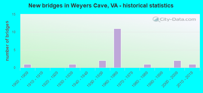
- New bridges - historical statistics
- 11900-1909
- 11930-1939
- 21950-1959
- 111960-1969
- 11980-1989
- 22000-2009
- 12010-2019


- Bridge Condition - Deck
- 14.3%Very good
- 28.6%Good
- 50.0%Satisfactory
- 7.1%Fair

- Bridge Condition - Superstructure
- 14.3%Very good
- 14.3%Good
- 42.9%Satisfactory
- 21.4%Fair
- 7.1%Poor

- Bridge Condition - Substructure
- 7.1%Very good
- 21.4%Good
- 28.6%Satisfactory
- 42.9%Fair

- Bridge Condition - Channel
- 30.0%Very good
- 10.0%Good
- 50.0%Satisfactory
- 10.0%Fair

- Bridge Condition - Culverts
- 50.0%Very good
- 50.0%Satisfactory
Find on map >> Show street view
Structure Number: 1772, Location: 6.58 TO 612 & 1.08 TO 256 (Lat: 38.272994, Lng: -78.937347), Route carried "on" structure: Interstate 81, Year Built: 1966, Status: Open, Structure Length: 5.85m (19.19ft), Average Daily Traffic: 23,588 (year 2020), Truck Traffic: 24%, Average Future Daily Traffic: 33,023 (year 2040), Design Load: HS 20+Mod, Features Intersected: NS RAILWAY
Minimum Vertical Clearance: 7.14m (23.43ft), Kilometerpoint: 378.147, Lanes on structure: 2, Base Highway Network: Yes, Owner: State Highway Agency, Approaching Roadway Width: 12.2m (40.0ft), Skew: 4 degrees, Material/Design: Steel, Design/Construction: Stringer/Multi-beam, Number Of Spans In Main Unit: 3, Length of Maximum Span: 19.6m (64.3ft), Curb-To-Curb Width: 12.2m (40.0ft), Out-to-Out Width: 12.8m (42.0ft)
Condition: Deck: Satisfactory, Superstructure: Fair, Substructure: Fair, Operating Rating: 56.2 metric tons, Method Used To Determine Operating Rating: Load and Resistance Factor (LRFR), Inventory Rating: 43.5 metric tons, Method Used To Determine Inventory Rating: Load and Resistance Factor (LRFR), Structural Evaluation: Somewhat better than minimum adequacy, Deck Geometry: Better than present minimum criteria, Underclear: Somewhat better than minimum adequacy, Approach Roadway Alignment: Equal to present desirable criteria, Designated Inspection Frequency: Every 24 months, Inspection Date: August 2021, Bridge Improvement Cost: $41,000, Roadway Improvement Cost: $4,000, Total Project Cost: $61,000, Deck Structure Type: Concrete Cast-file-Place, Wearing Surface/Protective System: Wearing Surface: Epoxy Overlay
Find on map >> Show street view
Structure Number: 1773, Location: 1.25 RT 256-0.43 ROCKINGM (Lat: 38.306806, Lng: -78.929769), Route carried "on" structure: Interstate 81, Year Built: 1966, Status: Open, Structure Length: 5.13m (16.83ft), Average Daily Traffic: 24,169 (year 2020), Truck Traffic: 24%, Average Future Daily Traffic: 33,837 (year 2040), Design Load: HS 20+Mod, Features Intersected: NAKED CREEK
Minimum Vertical Clearance: 30+ m (98+ ft), Kilometerpoint: 381.446, Lanes on structure: 2, Base Highway Network: Yes, Owner: State Highway Agency, Approaching Roadway Width: 12.2m (40.0ft), Material/Design: Prestressed concrete, Design/Construction: Stringer/Multi-beam, Number Of Spans In Main Unit: 3, Length of Maximum Span: 17.1m (56.1ft), Curb-To-Curb Width: 12.2m (40.0ft), Out-to-Out Width: 12.8m (42.0ft)
Condition: Deck: Satisfactory, Superstructure: Satisfactory, Substructure: Satisfactory, Channel: Satisfactory, Operating Rating: 78.0 metric tons, Method Used To Determine Operating Rating: Load and Resistance Factor (LRFR), Inventory Rating: 57.2 metric tons, Method Used To Determine Inventory Rating: Load and Resistance Factor (LRFR), Structural Evaluation: Equal to present minimum criteria, Deck Geometry: Better than present minimum criteria, Waterway Adequacy: Equal to present desirable criteria, Approach Roadway Alignment: Equal to present desirable criteria, Designated Inspection Frequency: Every 24 months, Inspection Date: December 2021, Bridge Improvement Cost: $52,000, Total Project Cost: $54,000, Deck Structure Type: Concrete Cast-file-Place, Wearing Surface/Protective System: Wearing Surface: Epoxy Overlay
Find on map >> Show street view
Structure Number: 1774, Location: 1.25 RT 256-0.43 ROCKINGM (Lat: 38.306789, Lng: -78.930103), Route carried "on" structure: Interstate 81, Year Built: 1966, Status: Open, Structure Length: 5.13m (16.83ft), Average Daily Traffic: 23,777 (year 2020), Truck Traffic: 23%, Average Future Daily Traffic: 33,288 (year 2040), Design Load: HS 20+Mod, Features Intersected: NAKED CREEK
Minimum Vertical Clearance: 30+ m (98+ ft), Kilometerpoint: 381.912, Lanes on structure: 2, Base Highway Network: Yes, Owner: State Highway Agency, Approaching Roadway Width: 12.2m (40.0ft), Material/Design: Prestressed concrete, Design/Construction: Stringer/Multi-beam, Number Of Spans In Main Unit: 3, Length of Maximum Span: 17.1m (56.1ft), Curb-To-Curb Width: 12.2m (40.0ft), Out-to-Out Width: 12.8m (42.0ft)
Condition: Deck: Satisfactory, Superstructure: Satisfactory, Substructure: Fair, Channel: Fair, Operating Rating: 78.0 metric tons, Method Used To Determine Operating Rating: Load and Resistance Factor (LRFR), Inventory Rating: 57.2 metric tons, Method Used To Determine Inventory Rating: Load and Resistance Factor (LRFR), Structural Evaluation: Somewhat better than minimum adequacy, Deck Geometry: Better than present minimum criteria, Waterway Adequacy: Equal to present desirable criteria, Approach Roadway Alignment: Equal to present desirable criteria, Designated Inspection Frequency: Every 24 months, Inspection Date: December 2021, Bridge Improvement Cost: $59,000, Total Project Cost: $62,000, Deck Structure Type: Concrete Cast-file-Place, Wearing Surface/Protective System: Wearing Surface: Epoxy Overlay
Find on map >> Show street view
Structure Number: 1902, Location: 0.15 TO 11 - 0.13 TO F222 (Lat: 38.288767, Lng: -78.933578), Route carried "on" structure: State highway 256, Year Built: 1966, Status: Open, Structure Length: 7.99m (26.21ft), Average Daily Traffic: 7,389 (year 2020), Truck Traffic: 6%, Average Future Daily Traffic: 8,452 (year 2040), Design Load: HS 20+Mod, Features Intersected: I-81
Minimum Vertical Clearance: 30+ m (98+ ft), Kilometerpoint: 0.352, Lanes on structure: 2, Lanes under structure: 4, Base Highway Network: Yes, Owner: State Highway Agency, Approaching Roadway Width: 7.6m (24.9ft), Material/Design: Prestressed concrete, Design/Construction: Stringer/Multi-beam, Number Of Spans In Main Unit: 4, Length of Maximum Span: 22.9m (75.1ft), Curb or Sidewalk Widths: Left: 0.5m (1.6ft), Right: 0.5m (1.6ft), Curb-To-Curb Width: 8.5m (27.9ft), Out-to-Out Width: 10.1m (33.1ft)
Condition: Deck: Good, Superstructure: Fair, Substructure: Satisfactory, Operating Rating: 75.3 metric tons, Method Used To Determine Operating Rating: Load and Resistance Factor (LRFR), Inventory Rating: 58.1 metric tons, Method Used To Determine Inventory Rating: Load and Resistance Factor (LRFR), Structural Evaluation: Somewhat better than minimum adequacy, Deck Geometry: Meets minimum limits, Underclear: Somewhat better than minimum adequacy, Approach Roadway Alignment: Better than present minimum criteria, Designated Inspection Frequency: Every 24 months, Inspection Date: July 2020, Bridge Improvement Cost: $92,000, Total Project Cost: $96,000, Deck Structure Type: Concrete Cast-file-Place, Wearing Surface/Protective System: Wearing Surface: Epoxy Overlay
Find on map >> Show street view
Structure Number: 1906, Location: 0.25 TO 772 - 0.40 TO 865 (Lat: 38.268000, Lng: -78.867511), Route carried "on" structure: State highway 256, Year Built: 1967, Status: Open, Structure Length: 13.02m (42.72ft), Average Daily Traffic: 5,736 (year 2020), Truck Traffic: 6%, Average Future Daily Traffic: 6,807 (year 2040), Design Load: HS 20+Mod, Features Intersected: MIDDLE RIVER, Facility Carried by Structure: WEYERS CAVE RD.
Minimum Vertical Clearance: 30+ m (98+ ft), Kilometerpoint: 6.613, Lanes on structure: 2, Base Highway Network: Yes, Owner: State Highway Agency, Approaching Roadway Width: 7.6m (24.9ft), Material/Design: Steel, Design/Construction: Stringer/Multi-beam, Number Of Spans In Main Unit: 5, Length of Maximum Span: 25.6m (84.0ft), Curb or Sidewalk Widths: Left: 0.2m (0.7ft), Right: 0.2m (0.7ft), Curb-To-Curb Width: 10.0m (32.8ft), Out-to-Out Width: 11.0m (36.1ft)
Condition: Deck: Satisfactory, Superstructure: Satisfactory, Substructure: Fair, Channel: Satisfactory, Operating Rating: 68.9 metric tons, Method Used To Determine Operating Rating: Load and Resistance Factor (LRFR), Inventory Rating: 53.5 metric tons, Method Used To Determine Inventory Rating: Load and Resistance Factor (LRFR), Structural Evaluation: Somewhat better than minimum adequacy, Deck Geometry: Meets minimum limits, Waterway Adequacy: Equal to present minimum criteria, Approach Roadway Alignment: Equal to present desirable criteria, Designated Inspection Frequency: Every 24 months, Inspection Date: December 2020, Deck Structure Type: Concrete Cast-file-Place, Wearing Surface/Protective System: Wearing Surface: Epoxy Overlay
Find on map >> Show street view
Structure Number: 2287, Location: 1.02 RT 11 - 0.23 RT 778 (Lat: 38.269644, Lng: -78.938278), Route carried "on" structure: County highway 750, Year Built: 1966, Status: Open, Structure Length: 8.91m (29.23ft), Average Daily Traffic: 2,707 (year 2020), Truck Traffic: 4%, Average Future Daily Traffic: 3,790 (year 2040), Design Load: HS 20+Mod, Features Intersected: RTE 81, Facility Carried by Structure: Keezletown Road
Minimum Vertical Clearance: 30+ m (98+ ft), Kilometerpoint: 1.617, Lanes on structure: 2, Lanes under structure: 4, Owner: State Highway Agency, Approaching Roadway Width: 8.5m (27.9ft), Skew: 2 degrees, Material/Design: Steel continuous, Design/Construction: Stringer/Multi-beam, Number Of Spans In Main Unit: 2, Number Of Approach Spans: 2, Length of Maximum Span: 25.5m (83.7ft), Curb or Sidewalk Widths: Left: 0.5m (1.6ft), Right: 0.5m (1.6ft), Curb-To-Curb Width: 8.5m (27.9ft), Out-to-Out Width: 10.1m (33.1ft)
Condition: Deck: Satisfactory, Superstructure: Satisfactory, Substructure: Satisfactory, Operating Rating: 51.7 metric tons, Method Used To Determine Operating Rating: Load and Resistance Factor (LRFR), Inventory Rating: 39.9 metric tons, Method Used To Determine Inventory Rating: Load and Resistance Factor (LRFR), Structural Evaluation: Equal to present minimum criteria, Deck Geometry: Meets minimum limits, Underclear: Equal to present minimum criteria, Approach Roadway Alignment: Equal to present minimum criteria, Designated Inspection Frequency: Every 24 months, Inspection Date: Febuary 2021, Bridge Improvement Cost: $46,000, Total Project Cost: $48,000, Deck Structure Type: Concrete Cast-file-Place, Wearing Surface/Protective System: Wearing Surface: Epoxy Overlay
Find on map >> Show street view
Structure Number: 2313, Location: 0.84 RT 900 - 0.54 RT 608 (Lat: 38.240983, Lng: -78.880892), Route carried "on" structure: County highway 775, Year Built: 1908, Status: Closed, Structure Length: 4.33m (14.21ft), Average Daily Traffic: 105 (year 2013), Average Future Daily Traffic: 132 (year 2040), Features Intersected: MIDDLE RIVER, Facility Carried by Structure: CRAIG SHOP RD.
Minimum Vertical Clearance: 5.12m (16.80ft), Kilometerpoint: 7.836, Lanes on structure: 1, Owner: State Highway Agency, Approaching Roadway Width: 2.4m (7.9ft), Material/Design: Steel, Design/Construction: Truss - Thru, Number Of Spans In Main Unit: 1, Length of Maximum Span: 41.1m (134.8ft), Curb or Sidewalk Widths: Left: 0.2m (0.7ft), Right: 0.2m (0.7ft), Curb-To-Curb Width: 3.3m (10.8ft), Out-to-Out Width: 3.7m (12.1ft)
Condition: Deck: Very good, Superstructure: Poor, Substructure: Fair, Channel: Very good, Waterway Adequacy: Equal to present minimum criteria, Approach Roadway Alignment: High priority of corrective action, Bridge Posting: Required (Relationship of Operating Rating to Maximum Legal Load: > 39.9% below), Length Of Structure Improvement: 4.33m (14.21ft), Designated Inspection Frequency: Every 12 months, Critical Feature Inspection Frequency: Every 12 months, Inspection Date: July 2019, Critical Feature Inspection Date: July 2019, Bridge Improvement Cost: $250,000, Roadway Improvement Cost: $20,000, Total Project Cost: $320,000, Deck Structure Type: Wood or Timber, Wearing Surface/Protective System: Wearing Surface: Bituminous
Find on map >> Show street view
Structure Number: 241, Location: 0.05 DEAD END-0.35 RT 768 (Lat: 38.301272, Lng: -78.910864), Route carried "on" structure: County highway 994, Year Built: 1930, Status: Posted for load, Structure Length: 2.10m (6.89ft), Average Daily Traffic: 45 (year 2013), Average Future Daily Traffic: 69 (year 2040), Features Intersected: SHENANDOAH VALLEY RR, Facility Carried by Structure: SAMUEL BEARS RD
Minimum Vertical Clearance: 30+ m (98+ ft), Kilometerpoint: 2.574, Lanes on structure: 1, Owner: Railroad, Approaching Roadway Width: 4.9m (16.1ft), Material/Design: Wood or Timber, Design/Construction: Stringer/Multi-beam, Number Of Spans In Main Unit: 5, Length of Maximum Span: 6.1m (20.0ft), Curb-To-Curb Width: 3.7m (12.1ft), Out-to-Out Width: 3.9m (12.8ft)
Condition: Deck: Fair, Superstructure: Fair, Substructure: Fair, Operating Rating: 6.4 metric tons, Method Used To Determine Operating Rating: Allowable Stress (AS), Inventory Rating: 4.5 metric tons, Method Used To Determine Inventory Rating: Allowable Stress (AS), Structural Evaluation: High priority of corrective action, Deck Geometry: Meets minimum limits, Underclear: High priority of corrective action, Approach Roadway Alignment: High priority of replacement, Bridge Posting: Required (Relationship of Operating Rating to Maximum Legal Load: > 39.9% below), Length Of Structure Improvement: 2.10m (6.89ft), Designated Inspection Frequency: Every 12 months, Inspection Date: January 2022, Bridge Improvement Cost: $128,000, Roadway Improvement Cost: $13,000, Total Project Cost: $192,000, Deck Structure Type: Wood or Timber
Find on map >> Show street view
Structure Number: 2411, Location: 0.27 RT 11 - 0.38 RT 992 (Lat: 38.309594, Lng: -78.930650), Route carried "on" structure: County highway 994, Year Built: 1966, Status: Open, Structure Length: 8.54m (28.02ft), Average Daily Traffic: 567 (year 2020), Truck Traffic: 8%, Average Future Daily Traffic: 794 (year 2040), Design Load: HS 20+Mod, Features Intersected: RTE. 81, Facility Carried by Structure: DICES SPRING RD.
Minimum Vertical Clearance: 30+ m (98+ ft), Kilometerpoint: 0.434, Lanes on structure: 2, Lanes under structure: 4, Owner: State Highway Agency, Approaching Roadway Width: 7.3m (24.0ft), Material/Design: Prestressed concrete, Design/Construction: Stringer/Multi-beam, Number Of Spans In Main Unit: 5, Length of Maximum Span: 18.9m (62.0ft), Curb or Sidewalk Widths: Left: 0.5m (1.6ft), Right: 0.5m (1.6ft), Curb-To-Curb Width: 7.3m (24.0ft), Out-to-Out Width: 8.8m (28.9ft)
Condition: Deck: Satisfactory, Superstructure: Satisfactory, Substructure: Fair, Operating Rating: 75.3 metric tons, Method Used To Determine Operating Rating: Load and Resistance Factor (LRFR), Inventory Rating: 51.7 metric tons, Method Used To Determine Inventory Rating: Load and Resistance Factor (LRFR), Structural Evaluation: Somewhat better than minimum adequacy, Deck Geometry: Meets minimum limits, Underclear: Somewhat better than minimum adequacy, Approach Roadway Alignment: Equal to present minimum criteria, Designated Inspection Frequency: Every 24 months, Inspection Date: October 2020, Bridge Improvement Cost: $46,000, Total Project Cost: $48,000, Deck Structure Type: Concrete Cast-file-Place, Wearing Surface/Protective System: Wearing Surface: Bituminous
Find on map >> Show street view
Structure Number: 2413, Location: 0.61 RT 11 - 0.02 RT 992 (Lat: 38.308353, Lng: -78.924719), Route carried "on" structure: County highway 994, Year Built: 1966, Status: Open, Structure Length: 3.32m (10.89ft), Average Daily Traffic: 567 (year 2020), Truck Traffic: 8%, Average Future Daily Traffic: 794 (year 2040), Design Load: HS 20+Mod, Features Intersected: NAKED CREEK, Facility Carried by Structure: DICES SPRING RD
Minimum Vertical Clearance: 30+ m (98+ ft), Kilometerpoint: 1.014, Lanes on structure: 2, Owner: State Highway Agency, Approaching Roadway Width: 5.8m (19.0ft), Skew: 1 degrees, Material/Design: Concrete, Design/Construction: Tee Beam, Number Of Spans In Main Unit: 3, Length of Maximum Span: 10.4m (34.1ft), Curb or Sidewalk Widths: Left: 0.5m (1.6ft), Right: 0.5m (1.6ft), Curb-To-Curb Width: 7.3m (24.0ft), Out-to-Out Width: 8.8m (28.9ft)
Condition: Deck: Good, Superstructure: Good, Substructure: Good, Channel: Very good, Operating Rating: 51.7 metric tons, Method Used To Determine Operating Rating: Load and Resistance Factor (LRFR), Inventory Rating: 37.2 metric tons, Method Used To Determine Inventory Rating: Load and Resistance Factor (LRFR), Structural Evaluation: Better than present minimum criteria, Deck Geometry: Meets minimum limits, Waterway Adequacy: Equal to present desirable criteria, Approach Roadway Alignment: Equal to present desirable criteria, Designated Inspection Frequency: Every 24 months, Inspection Date: October 2021, Deck Structure Type: Concrete Cast-file-Place, Wearing Surface/Protective System: Wearing Surface: Epoxy Overlay
Find on map >> Show street view
Structure Number: 2705, Location: 0.20-RT 221;0.10-RT 661 (Lat: 37.363797, Lng: -79.264794), Route carried "on" structure: County highway 620, Year Built: 1950, Status: Posted for load, Structure Length: 2.03m (6.66ft), Average Daily Traffic: 1,083 (year 2019), Average Future Daily Traffic: 1,538 (year 2040), Features Intersected: NS RAILWAY, Facility Carried by Structure: BATEMAN BRIDGE RD
Minimum Vertical Clearance: 30+ m (98+ ft), Kilometerpoint: 0.011, Lanes on structure: 1, Owner: State Highway Agency, Approaching Roadway Width: 4.9m (16.1ft), Material/Design: Wood or Timber, Design/Construction: Stringer/Multi-beam, Number Of Spans In Main Unit: 5, Length of Maximum Span: 5.9m (19.4ft), Curb or Sidewalk Widths: Left: 0.2m (0.7ft), Right: 0.2m (0.7ft), Curb-To-Curb Width: 3.3m (10.8ft), Out-to-Out Width: 3.7m (12.1ft)
Condition: Deck: Very good, Superstructure: Very good, Substructure: Good, Operating Rating: 18.1 metric tons, Method Used To Determine Operating Rating: Allowable Stress (AS), Inventory Rating: 13.6 metric tons, Method Used To Determine Inventory Rating: Allowable Stress (AS), Structural Evaluation: Meets minimum limits, Deck Geometry: High priority of replacement, Underclear: High priority of corrective action, Approach Roadway Alignment: High priority of corrective action, Bridge Posting: Required (Relationship of Operating Rating to Maximum Legal Load: 10.0 - 19.9% below), Length Of Structure Improvement: 2.29m (7.51ft), Designated Inspection Frequency: Every 12 months, Inspection Date: Febuary 2021, Bridge Improvement Cost: $966,000, Roadway Improvement Cost: $241,000, Total Project Cost: $3,090,000 ( Estimate for 2019), Deck Structure Type: Wood or Timber
Find on map >> Show street view
Structure Number: 15883, Location: 0.00 AUGCO - 0.00 ROCKCO (Lat: 38.305833, Lng: -78.893753), Route carried "on" structure: State highway 276, Year Built: 1957, Year Reconstructed: 1995, Status: Open, Structure Length: 12.41m (40.72ft), Average Daily Traffic: 4,278 (year 2020), Truck Traffic: 3%, Average Future Daily Traffic: 4,486 (year 2040), Design Load: HS 20+Mod, Features Intersected: NORTH RV @ WEYERS-CAVE
Minimum Vertical Clearance: 30+ m (98+ ft), Kilometerpoint: 2.864, Lanes on structure: 2, Base Highway Network: Yes, Owner: State Highway Agency, Approaching Roadway Width: 6.7m (22.0ft), Material/Design: Steel, Design/Construction: Stringer/Multi-beam, Number Of Spans In Main Unit: 6, Length of Maximum Span: 20.6m (67.6ft), Curb or Sidewalk Widths: Left: 0.5m (1.6ft), Right: 0.5m (1.6ft), Curb-To-Curb Width: 7.3m (24.0ft), Out-to-Out Width: 8.8m (28.9ft)
Condition: Deck: Satisfactory, Superstructure: Satisfactory, Substructure: Satisfactory, Channel: Good, Operating Rating: 49.0 metric tons, Method Used To Determine Operating Rating: Load and Resistance Factor (LRFR), Inventory Rating: 37.2 metric tons, Method Used To Determine Inventory Rating: Load and Resistance Factor (LRFR), Structural Evaluation: Equal to present minimum criteria, Deck Geometry: High priority of replacement, Waterway Adequacy: Equal to present minimum criteria, Approach Roadway Alignment: Equal to present desirable criteria, Length Of Structure Improvement: 12.41m (40.72ft), Designated Inspection Frequency: Every 24 months, Inspection Date: April 2021, Bridge Improvement Cost: $250,000, Roadway Improvement Cost: $28,000, Total Project Cost: $300,000, Deck Structure Type: Concrete Cast-file-Place, Wearing Surface/Protective System: Wearing Surface: Latex Concrete
Find on map >> Show street view
Structure Number: 16254, Location: 0.40 RT 276 -1.00DEAD END (Lat: 38.307178, Lng: -78.895764), Route carried "on" structure: County highway 994, Year Built: 1988, Status: Open, Structure Length: 0.64m (2.10ft), Average Daily Traffic: 66 (year 2018), Average Future Daily Traffic: 82 (year 2040), Features Intersected: TRIB NORTH RIVER, Facility Carried by Structure: IRONHORSE RD
Minimum Vertical Clearance: 30+ m (98+ ft), Kilometerpoint: 1.685, Lanes on structure: 2, Owner: State Highway Agency, Approaching Roadway Width: 4.9m (16.1ft), Skew: 3 degrees, Material/Design: Steel, Design/Construction: Culvert, Number Of Spans In Main Unit: 1, Length of Maximum Span: 5.2m (17.1ft)
Condition: Channel: Very good, Culverts: Satisfactory, Operating Rating: 51.7 metric tons, Method Used To Determine Operating Rating: Field evaluation and documented engineering judgment, Inventory Rating: 30.8 metric tons, Method Used To Determine Inventory Rating: Field evaluation and documented engineering judgment, Structural Evaluation: Equal to present minimum criteria, Waterway Adequacy: Better than present minimum criteria, Approach Roadway Alignment: Equal to present desirable criteria, Designated Inspection Frequency: Every 24 months, Inspection Date: January 2021
Find on map >> Show street view
Structure Number: 27375, Location: 0.26 RT 994 - 0.04 RT 680 (Lat: 38.306142, Lng: -78.935408), Route carried "on" structure: US 11, Year Built: 2003, Status: Open, Structure Length: 3.70m (12.14ft), Average Daily Traffic: 6,361 (year 2020), Truck Traffic: 2%, Average Future Daily Traffic: 6,997 (year 2040), Design Load: HS 20+Mod, Features Intersected: NAKED CREEK, Facility Carried by Structure: Lee-Jackson Hwy
Minimum Vertical Clearance: 30+ m (98+ ft), Kilometerpoint: 404.567, Lanes on structure: 2, Base Highway Network: Yes, Owner: State Highway Agency, Approaching Roadway Width: 8.5m (27.9ft), Material/Design: Steel continuous, Design/Construction: Stringer/Multi-beam, Number Of Spans In Main Unit: 2, Length of Maximum Span: 17.7m (58.1ft), Curb-To-Curb Width: 12.1m (39.7ft), Out-to-Out Width: 12.9m (42.3ft)
Condition: Deck: Good, Superstructure: Very good, Substructure: Very good, Channel: Satisfactory, Operating Rating: 66.2 metric tons, Method Used To Determine Operating Rating: Load and Resistance Factor (LRFR), Inventory Rating: 50.8 metric tons, Method Used To Determine Inventory Rating: Load and Resistance Factor (LRFR), Structural Evaluation: Equal to present desirable criteria, Deck Geometry: Somewhat better than minimum adequacy, Waterway Adequacy: Equal to present minimum criteria, Approach Roadway Alignment: Equal to present desirable criteria, Designated Inspection Frequency: Every 24 months, Inspection Date: March 2022, Deck Structure Type: Concrete Cast-file-Place, Wearing Surface/Protective System: Deck Protection: Epoxy Coated Reinforcing
Find on map >> Show street view
Structure Number: 28355, Location: 1.52RT 769 - 0.19 RT 775 (Lat: 38.251022, Lng: -78.892047), Route carried "on" structure: County highway 900, Year Built: 2006, Status: Open, Structure Length: 0.76m (2.49ft), Average Daily Traffic: 77 (year 2013), Average Future Daily Traffic: 78 (year 2040), Design Load: HS 20+Mod, Features Intersected: BROAD RUN, Facility Carried by Structure: Little Run Road
Minimum Vertical Clearance: 30+ m (98+ ft), Kilometerpoint: 0.286, Lanes on structure: 2, Owner: State Highway Agency, Approaching Roadway Width: 4.3m (14.1ft), Skew: 2 degrees, Material/Design: Concrete, Design/Construction: Box Beam or Girders - Multiple, Number Of Spans In Main Unit: 1, Length of Maximum Span: 7.0m (23.0ft), Curb-To-Curb Width: 7.3m (24.0ft), Out-to-Out Width: 7.5m (24.6ft)
Condition: Deck: Good, Superstructure: Good, Substructure: Good, Channel: Satisfactory, Inventory Rating: 90.5 metric tons, Method Used To Determine Inventory Rating: Load and Resistance Factor (LRFR), Structural Evaluation: Better than present minimum criteria, Deck Geometry: Equal to present minimum criteria, Waterway Adequacy: Equal to present minimum criteria, Approach Roadway Alignment: Somewhat better than minimum adequacy, Designated Inspection Frequency: Every 24 months, Inspection Date: May 2020, Deck Structure Type: Other, Wearing Surface/Protective System: Wearing Surface: Bituminous, Membrane: Epoxy
Find on map >> Show street view
Structure Number: 30425, Location: .033Aut.Bluffdr-.033DeadE (Lat: 38.280278, Lng: -78.909167), Route carried "on" structure: ServiceCounty highway 2042, Year Built: 2014, Status: Open, Structure Length: 0.73m (2.40ft), Average Daily Traffic: 40 (year 2014), Average Future Daily Traffic: 50 (year 2034), Design Load: HS 20, Features Intersected: Trib. North River, Facility Carried by Structure: Briar Creek Circle
Minimum Vertical Clearance: 30+ m (98+ ft), Kilometerpoint: 0.000, Lanes on structure: 2, Owner: State Highway Agency, Approaching Roadway Width: 8.8m (28.9ft), Design/Construction: Culvert, Number Of Spans In Main Unit: 1, Length of Maximum Span: 1.5m (4.9ft)
Condition: Channel: Satisfactory, Culverts: Very good, Operating Rating: 44.5 metric tons, Method Used To Determine Operating Rating: Field evaluation and documented engineering judgment, Inventory Rating: 32.7 metric tons, Method Used To Determine Inventory Rating: Field evaluation and documented engineering judgment, Structural Evaluation: Equal to present desirable criteria, Waterway Adequacy: Equal to present desirable criteria, Approach Roadway Alignment: Equal to present desirable criteria, Designated Inspection Frequency: Every 24 months, Inspection Date: May 2020
Find on map >> Show street view
Structure Number: 1902, Location: 0.15 TO 11 - 0.13 TO F222 (Lat: 38.288767, Lng: -78.933578), Route carried "under" structure: Interstate 81, Year Built: 1966, Structure Length: 0. m, Average Daily Traffic: 47,488 (year 2008), Truck Traffic: 12%, Features Intersected: I-81, Facility Carried by Structure: ROUTE 0256
Minimum Vertical Clearance: 5.36m (17.59ft), Kilometerpoint: 379.450, Lanes on structure: 2, Lanes under structure: 4, Material/Design: Prestressed concrete, Design/Construction: Stringer/Multi-beam, Length of Maximum Span: 22.9m (75.1ft)
Find on map >> Show street view
Structure Number: 2287, Location: 1.02 RT 11 - 0.23 RT 778 (Lat: 38.269644, Lng: -78.938278), Route carried "under" structure: Interstate 81, Year Built: 1966, Structure Length: 0. m, Average Daily Traffic: 45,782 (year 2008), Truck Traffic: 12%, Features Intersected: RTE 81, Facility Carried by Structure: Keezletown Road
Minimum Vertical Clearance: 5.23m (17.16ft), Kilometerpoint: 377.327, Lanes on structure: 2, Lanes under structure: 4, Material/Design: Steel continuous, Design/Construction: Stringer/Multi-beam, Length of Maximum Span: 25.5m (83.7ft)
Find on map >> Show street view
Structure Number: 2411, Location: 0.27 RT 11 - 0.38 RT 992 (Lat: 38.309594, Lng: -78.930650), Route carried "under" structure: Interstate 81, Year Built: 1966, Structure Length: 0. m, Average Daily Traffic: 47,488 (year 2008), Truck Traffic: 12%, Features Intersected: RTE. 81, Facility Carried by Structure: DICES SPRING RD.
Minimum Vertical Clearance: 7.21m (23.65ft), Kilometerpoint: 381.751, Lanes on structure: 2, Lanes under structure: 4, Material/Design: Prestressed concrete, Design/Construction: Stringer/Multi-beam, Length of Maximum Span: 18.9m (62.0ft)