Bridge Statistics for Westville, New Jersey (NJ)
Condition, Traffic, Stress, Structural Evaluation, Project Costs
- National Bridge Inventory (NBI) Statistics
- 19Number of bridges
- 220ft / 66.5mTotal length
- $27,587,000Total costs
- 558,246Total average daily traffic
- 48,650Total average daily truck traffic
- National Bridge Inventory (NBI) Registered Bridges for Westville
- No street view available for this location
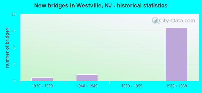
- New bridges - historical statistics
- 11930-1939
- 21940-1949
- 161960-1969

- Reconstructed bridges - Historical Statistics
- 11980-1989
- 31990-1999
- 02000-2009
- 12010-2019


- Bridge Condition - Deck
- 18.2%Very good
- 27.3%Good
- 27.3%Satisfactory
- 18.2%Fair
- 9.1%Poor

- Bridge Condition - Superstructure
- 9.1%Excellent
- 9.1%Good
- 36.4%Satisfactory
- 36.4%Fair
- 9.1%Poor

- Bridge Condition - Substructure
- 36.4%Good
- 45.5%Satisfactory
- 9.1%Fair
- 9.1%Poor

- Bridge Condition - Channel
- 66.7%Good
- 33.3%Satisfactory
Find on map >> Show street view
Structure Number: 81515, Location: 1.2 MI S OF RT.130 (Lat: 39.859211, Lng: -75.125150), Route carried "on" structure: State highway 47, Year Built: 1960, Status: Open, Structure Length: 5.52m (18.11ft), Average Daily Traffic: 11,835 (year 2020), Truck Traffic: 4%, Average Future Daily Traffic: 14,441 (year 2040), Design Load: HS 20, Features Intersected: I-295
Minimum Vertical Clearance: 30+ m (98+ ft), Kilometerpoint: 119.108, Lanes on structure: 4, Lanes under structure: 8, Owner: State Highway Agency, Approaching Roadway Width: 19.8m (65.0ft), Material/Design: Prestressed concrete, Design/Construction: Stringer/Multi-beam, Number Of Spans In Main Unit: 2, Length of Maximum Span: 26.5m (86.9ft), Curb or Sidewalk Widths: Left: 1.8m (5.9ft), Right: 1.8m (5.9ft), Curb-To-Curb Width: 19.8m (65.0ft), Out-to-Out Width: 24.1m (79.1ft)
Condition: Deck: Very good, Superstructure: Excellent, Substructure: Good, Operating Rating: 79.8 metric tons, Method Used To Determine Operating Rating: Load Factor (LF), Inventory Rating: 48.1 metric tons, Method Used To Determine Inventory Rating: Load Factor (LF), Structural Evaluation: Better than present minimum criteria, Deck Geometry: Better than present minimum criteria, Underclear: High priority of replacement, Approach Roadway Alignment: Equal to present desirable criteria, Length Of Structure Improvement: 5.52m (18.11ft), Designated Inspection Frequency: Every 24 months, Inspection Date: August 2020, Bridge Improvement Cost: $4,667,000, Roadway Improvement Cost: $203,000, Total Project Cost: $6,160,000 ( Estimate for 2018), Deck Structure Type: Concrete Cast-file-Place, Wearing Surface/Protective System: Wearing Surface: Monolithic Concrete
Find on map >> Show street view
Structure Number: 815152, Location: AT BIG TIMBER CREEK (Lat: 39.873681, Lng: -75.124369), Route carried "on" structure: State highway 47, Year Built: 1934, Status: Open, Structure Length: 9.97m (32.71ft), Average Daily Traffic: 22,083 (year 2018), Truck Traffic: 4%, Average Future Daily Traffic: 26,946 (year 2038), Features Intersected: BIG TIMBER CREEK
Minimum Vertical Clearance: 30+ m (98+ ft), Kilometerpoint: 120.846, Lanes on structure: 4, Owner: State Highway Agency, Approaching Roadway Width: 14.3m (46.9ft), Skew: 2 degrees, Material/Design: Steel, Design/Construction: Girder and Floorbeam System, Number Of Spans In Main Unit: 1, Number Of Approach Spans: 5, Length of Maximum Span: 24.7m (81.0ft), Curb or Sidewalk Widths: Left: 1.9m (6.2ft), Right: 1.9m (6.2ft), Curb-To-Curb Width: 14.0m (45.9ft), Out-to-Out Width: 15.5m (50.9ft)
Condition: Deck: Poor, Superstructure: Poor, Substructure: Poor, Channel: Good, Operating Rating: 63.5 metric tons, Method Used To Determine Operating Rating: Load Factor (LF), Inventory Rating: 38.1 metric tons, Method Used To Determine Inventory Rating: Load Factor (LF), Structural Evaluation: Meets minimum limits, Deck Geometry: High priority of replacement, Waterway Adequacy: Superior to present desirable criteria, Approach Roadway Alignment: Equal to present minimum criteria, Length Of Structure Improvement: 10.97m (35.99ft), Designated Inspection Frequency: Every 24 months, Critical Feature Inspection Frequency: Every 24 months, Underwater Inspection Frequency: Every 24 months, Inspection Date: July 2020, Critical Feature Inspection Date: July 2020, Underwater Inspection Date: June 2020, Bridge Improvement Cost: $15,528,000, Roadway Improvement Cost: $1,164,000, Total Project Cost: $18,439,000 ( Estimate for 2018), Deck Structure Type: Other, Wearing Surface/Protective System: Wearing Surface: Integral Concrete
Find on map >> Show street view
Structure Number: 81815, Location: .8 MI N OF I-295 & NJ 45 (Lat: 39.870281, Lng: -75.129719), Route carried "on" structure: US 130, Year Built: 1947, Status: Open, Structure Length: 2.04m (6.69ft), Average Daily Traffic: 12,840 (year 2021), Truck Traffic: 4%, Average Future Daily Traffic: 15,408 (year 2041), Design Load: H 20, Features Intersected: NJ 45 SB
Minimum Vertical Clearance: 30+ m (98+ ft), Kilometerpoint: 40.411, Lanes on structure: 2, Lanes under structure: 2, Base Highway Network: Yes, Owner: State Highway Agency, Approaching Roadway Width: 10.7m (35.1ft), Skew: 4 degrees, Material/Design: Steel, Design/Construction: Stringer/Multi-beam, Number Of Spans In Main Unit: 1, Length of Maximum Span: 19.2m (63.0ft), Curb or Sidewalk Widths: Left: 0.9m (3.0ft), Right: 1.9m (6.2ft), Curb-To-Curb Width: 10.7m (35.1ft), Out-to-Out Width: 14.0m (45.9ft)
Condition: Deck: Fair, Superstructure: Satisfactory, Substructure: Satisfactory, Operating Rating: 82.6 metric tons, Method Used To Determine Operating Rating: Load Factor (LF), Inventory Rating: 49.9 metric tons, Method Used To Determine Inventory Rating: Load Factor (LF), Structural Evaluation: Equal to present minimum criteria, Deck Geometry: Somewhat better than minimum adequacy, Underclear: Equal to present minimum criteria, Approach Roadway Alignment: Equal to present minimum criteria, Designated Inspection Frequency: Every 24 months, Inspection Date: June 2021, Deck Structure Type: Concrete Cast-file-Place, Wearing Surface/Protective System: Wearing Surface: Monolithic Concrete
Find on map >> Show street view
Structure Number: 82315, Location: AT I-295 EXIT 24 (Lat: 39.858619, Lng: -75.138939), Route carried "on" structure: Ramp Interstate 295, Year Built: 1960, Year Reconstructed: 2016, Status: Open, Structure Length: 1.83m (6.00ft), Average Daily Traffic: 7,995 (year 2021), Truck Traffic: 9%, Average Future Daily Traffic: 9,755 (year 2041), Design Load: HS 20+Mod, Features Intersected: NJ 45 SB
Minimum Vertical Clearance: 30+ m (98+ ft), Kilometerpoint: 39.413, Lanes on structure: 1, Lanes under structure: 2, Owner: State Highway Agency, Approaching Roadway Width: 7.3m (24.0ft), Skew: 2 degrees, Material/Design: Prestressed concrete, Design/Construction: Stringer/Multi-beam, Number Of Spans In Main Unit: 1, Length of Maximum Span: 16.2m (53.1ft), Curb or Sidewalk Widths: Left: 0.8m (2.6ft), Right: 0.5m (1.6ft), Curb-To-Curb Width: 8.2m (26.9ft), Out-to-Out Width: 9.2m (30.2ft)
Condition: Deck: Very good, Superstructure: Good, Substructure: Good, Operating Rating: 66.2 metric tons, Method Used To Determine Operating Rating: Load Factor (LF), Inventory Rating: 39.0 metric tons, Method Used To Determine Inventory Rating: Load Factor (LF), Structural Evaluation: Better than present minimum criteria, Deck Geometry: Superior to present desirable criteria, Underclear: Equal to present minimum criteria, Approach Roadway Alignment: Equal to present minimum criteria, Designated Inspection Frequency: Every 24 months, Inspection Date: July 2021, Bridge Improvement Cost: $363,000, Roadway Improvement Cost: $36,000, Total Project Cost: $439,000 ( Estimate for 2019), Deck Structure Type: Concrete Cast-file-Place, Wearing Surface/Protective System: Wearing Surface: Monolithic Concrete
Find on map >> Show street view
Structure Number: 823151, Location: 0.65 MI SOUTH OF NJ 47 (Lat: 39.859819, Lng: -75.137761), Route carried "on" structure: Interstate 295, Year Built: 1960, Status: Open, Structure Length: 8.41m (27.59ft), Average Daily Traffic: 39,730 (year 2020), Truck Traffic: 9%, Average Future Daily Traffic: 47,742 (year 2040), Design Load: HS 20+Mod, Features Intersected: NJ 45 & NSRR
Minimum Vertical Clearance: 30+ m (98+ ft), Kilometerpoint: 39.477, Lanes on structure: 4, Lanes under structure: 4, Base Highway Network: Yes, Owner: State Highway Agency, Approaching Roadway Width: 16.8m (55.1ft), Skew: 1 degrees, Material/Design: Prestressed concrete, Design/Construction: Stringer/Multi-beam, Number Of Spans In Main Unit: 5, Length of Maximum Span: 20.1m (65.9ft), Curb-To-Curb Width: 16.8m (55.1ft), Out-to-Out Width: 17.8m (58.4ft)
Condition: Deck: Good, Superstructure: Satisfactory, Substructure: Satisfactory, Operating Rating: 49.9 metric tons, Method Used To Determine Operating Rating: Load Factor (LF), Inventory Rating: 26.3 metric tons, Method Used To Determine Inventory Rating: Load Factor (LF), Structural Evaluation: Equal to present minimum criteria, Deck Geometry: Meets minimum limits, Underclear: Equal to present minimum criteria, Approach Roadway Alignment: Equal to present desirable criteria, Designated Inspection Frequency: Every 24 months, Inspection Date: August 2020, Deck Structure Type: Concrete Cast-file-Place, Wearing Surface/Protective System: Wearing Surface: Latex Concrete
Find on map >> Show street view
Structure Number: 823152, Location: AT I-295 EXIT 24 (Lat: 39.860031, Lng: -75.137511), Route carried "on" structure: Interstate 295, Year Built: 1960, Year Reconstructed: 1991, Status: Open, Structure Length: 8.11m (26.61ft), Average Daily Traffic: 36,975 (year 2021), Truck Traffic: 9%, Average Future Daily Traffic: 44,370 (year 2041), Design Load: HS 20, Features Intersected: NJ 45 & CONRAIL
Minimum Vertical Clearance: 30+ m (98+ ft), Kilometerpoint: 39.477, Lanes on structure: 4, Lanes under structure: 5, Base Highway Network: Yes, Owner: State Highway Agency, Approaching Roadway Width: 16.8m (55.1ft), Skew: 1 degrees, Material/Design: Prestressed concrete, Design/Construction: Stringer/Multi-beam, Number Of Spans In Main Unit: 5, Length of Maximum Span: 19.5m (64.0ft), Curb-To-Curb Width: 16.8m (55.1ft), Out-to-Out Width: 17.8m (58.4ft)
Condition: Deck: Satisfactory, Superstructure: Fair, Substructure: Good, Operating Rating: 27.2 metric tons, Method Used To Determine Operating Rating: Load Factor (LF), Inventory Rating: 15.4 metric tons, Method Used To Determine Inventory Rating: Load Factor (LF), Structural Evaluation: High priority of corrective action, Deck Geometry: Meets minimum limits, Underclear: Equal to present minimum criteria, Approach Roadway Alignment: Equal to present desirable criteria, Designated Inspection Frequency: Every 24 months, Inspection Date: September 2021, Deck Structure Type: Concrete Cast-file-Place, Wearing Surface/Protective System: Wearing Surface: Latex Concrete
Find on map >> Show street view
Structure Number: 823153, Location: 0.58 MI S. OF 295 EXIT 25 (Lat: 39.859411, Lng: -75.135664), Route carried "on" structure: Interstate 295, Year Built: 1960, Status: Open, Structure Length: 4.79m (15.72ft), Average Daily Traffic: 79,304 (year 2020), Truck Traffic: 9%, Average Future Daily Traffic: 95,165 (year 2040), Design Load: HS 20, Features Intersected: BROADWAY AVENUE
Minimum Vertical Clearance: 30+ m (98+ ft), Kilometerpoint: 39.590, Lanes on structure: 4, Lanes under structure: 3, Base Highway Network: Yes, Owner: State Highway Agency, Approaching Roadway Width: 16.8m (55.1ft), Skew: 1 degrees, Material/Design: Prestressed concrete, Design/Construction: Stringer/Multi-beam, Number Of Spans In Main Unit: 3, Length of Maximum Span: 26.2m (86.0ft), Curb-To-Curb Width: 16.8m (55.1ft), Out-to-Out Width: 18.0m (59.1ft)
Condition: Deck: Satisfactory, Superstructure: Satisfactory, Substructure: Satisfactory, Operating Rating: 73.5 metric tons, Method Used To Determine Operating Rating: Load Factor (LF), Inventory Rating: 43.5 metric tons, Method Used To Determine Inventory Rating: Load Factor (LF), Structural Evaluation: Equal to present minimum criteria, Deck Geometry: High priority of replacement, Underclear: Equal to present minimum criteria, Approach Roadway Alignment: Equal to present desirable criteria, Length Of Structure Improvement: 4.80m (15.75ft), Designated Inspection Frequency: Every 24 months, Inspection Date: Febuary 2020, Bridge Improvement Cost: $476,000, Roadway Improvement Cost: $119,000, Total Project Cost: $794,000 ( Estimate for 2020), Deck Structure Type: Concrete Cast-file-Place, Wearing Surface/Protective System: Wearing Surface: Latex Concrete
Find on map >> Show street view
Structure Number: 823154, Location: AT I-295 EXIT 24 (Lat: 39.859819, Lng: -75.135319), Route carried "on" structure: Interstate 295, Year Built: 1960, Year Reconstructed: 1990, Status: Open, Structure Length: 4.79m (15.72ft), Average Daily Traffic: 31,991 (year 2020), Truck Traffic: 9%, Average Future Daily Traffic: 44,788 (year 2040), Design Load: HS 20, Features Intersected: BROADWAY AVENUE
Minimum Vertical Clearance: 30+ m (98+ ft), Kilometerpoint: 39.590, Lanes on structure: 4, Lanes under structure: 3, Owner: State Highway Agency, Approaching Roadway Width: 16.8m (55.1ft), Skew: 1 degrees, Material/Design: Prestressed concrete, Design/Construction: Stringer/Multi-beam, Number Of Spans In Main Unit: 3, Length of Maximum Span: 26.2m (86.0ft), Curb-To-Curb Width: 16.8m (55.1ft), Out-to-Out Width: 18.0m (59.1ft)
Condition: Deck: Satisfactory, Superstructure: Satisfactory, Substructure: Satisfactory, Operating Rating: 82.6 metric tons, Method Used To Determine Operating Rating: Load Factor (LF), Inventory Rating: 33.6 metric tons, Method Used To Determine Inventory Rating: Load Factor (LF), Structural Evaluation: Equal to present minimum criteria, Deck Geometry: High priority of replacement, Underclear: Equal to present minimum criteria, Approach Roadway Alignment: Equal to present desirable criteria, Length Of Structure Improvement: 4.79m (15.72ft), Designated Inspection Frequency: Every 24 months, Inspection Date: Febuary 2020, Bridge Improvement Cost: $449,000, Roadway Improvement Cost: $110,000, Total Project Cost: $728,000 ( Estimate for 2020), Deck Structure Type: Concrete Cast-file-Place, Wearing Surface/Protective System: Wearing Surface: Latex Concrete
Find on map >> Show street view
Structure Number: 823156, Location: 0.31 Mi North of Exit 25 (Lat: 39.860219, Lng: -75.119850), Route carried "on" structure: County highway 621, Year Built: 1960, Status: Open, Structure Length: 5.61m (18.41ft), Average Daily Traffic: 10,345 (year 2019), Truck Traffic: 4%, Average Future Daily Traffic: 14,500 (year 2039), Design Load: HS 20, Features Intersected: I-295, Facility Carried by Structure: Almonesson Road
Minimum Vertical Clearance: 30+ m (98+ ft), Kilometerpoint: 9.125, Lanes on structure: 2, Lanes under structure: 7, Owner: State Highway Agency, Approaching Roadway Width: 14.0m (45.9ft), Skew: 1 degrees, Material/Design: Prestressed concrete, Design/Construction: Stringer/Multi-beam, Number Of Spans In Main Unit: 2, Length of Maximum Span: 26.8m (87.9ft), Curb or Sidewalk Widths: Left: 1.8m (5.9ft), Right: 1.8m (5.9ft), Curb-To-Curb Width: 14.0m (45.9ft), Out-to-Out Width: 18.4m (60.4ft)
Condition: Deck: Fair, Superstructure: Fair, Substructure: Good, Inventory Rating: 43.5 metric tons, Method Used To Determine Inventory Rating: Allowable Stress (AS), Structural Evaluation: Somewhat better than minimum adequacy, Deck Geometry: Superior to present desirable criteria, Underclear: High priority of corrective action, Approach Roadway Alignment: Equal to present desirable criteria, Length Of Structure Improvement: 5.61m (18.41ft), Designated Inspection Frequency: Every 24 months, Inspection Date: July 2021, Bridge Improvement Cost: $707,000, Roadway Improvement Cost: $142,000, Total Project Cost: $1,027,000 ( Estimate for 2019), Deck Structure Type: Concrete Cast-file-Place, Wearing Surface/Protective System: Wearing Surface: Monolithic Concrete
Find on map >> Show street view
Structure Number: 823157, Location: 0.9 MI SOUTH OF RT 42 JCT (Lat: 39.861131, Lng: -75.115881), Route carried "on" structure: Interstate 295, Year Built: 1960, Year Reconstructed: 1995, Status: Open, Structure Length: 7.74m (25.39ft), Average Daily Traffic: 37,853 (year 2020), Truck Traffic: 9%, Average Future Daily Traffic: 45,423 (year 2040), Design Load: HS 20, Features Intersected: BIG TIMBER CREEK
Minimum Vertical Clearance: 30+ m (98+ ft), Kilometerpoint: 41.408, Lanes on structure: 3, Base Highway Network: Yes, Owner: State Highway Agency, Approaching Roadway Width: 15.2m (49.9ft), Navigation Control: Yes ( Vertical Clearance: 3.7m (12.1ft), Horizontal Clearance: 19.5m (64.0ft)), Material/Design: Prestressed concrete, Design/Construction: Stringer/Multi-beam, Number Of Spans In Main Unit: 4, Length of Maximum Span: 20.7m (67.9ft), Curb-To-Curb Width: 15.2m (49.9ft), Out-to-Out Width: 16.9m (55.4ft)
Condition: Deck: Good, Superstructure: Fair, Substructure: Satisfactory, Channel: Satisfactory, Operating Rating: 59.0 metric tons, Method Used To Determine Operating Rating: Load Factor (LF), Inventory Rating: 33.6 metric tons, Method Used To Determine Inventory Rating: Load Factor (LF), Structural Evaluation: Somewhat better than minimum adequacy, Deck Geometry: Meets minimum limits, Waterway Adequacy: Equal to present minimum criteria, Approach Roadway Alignment: Equal to present desirable criteria, Designated Inspection Frequency: Every 24 months, Underwater Inspection Frequency: Every 48 months, Inspection Date: April 2020, Underwater Inspection Date: April 2020, Deck Structure Type: Concrete Cast-file-Place, Wearing Surface/Protective System: Wearing Surface: Latex Concrete
Find on map >> Show street view
Structure Number: 823158, Location: 0.55 MI N OF RT 47 JCT (Lat: 39.861831, Lng: -75.115361), Route carried "on" structure: Interstate 295, Year Built: 1960, Year Reconstructed: 1995, Status: Open, Structure Length: 7.74m (25.39ft), Average Daily Traffic: 39,594 (year 2020), Truck Traffic: 9%, Average Future Daily Traffic: 58,995 (year 2040), Design Load: HS 20, Features Intersected: BIG TIMBER CREEK
Minimum Vertical Clearance: 30+ m (98+ ft), Kilometerpoint: 41.408, Lanes on structure: 3, Base Highway Network: Yes, Owner: State Highway Agency, Approaching Roadway Width: 15.2m (49.9ft), Navigation Control: Yes ( Vertical Clearance: 3.7m (12.1ft), Horizontal Clearance: 19.2m (63.0ft)), Material/Design: Prestressed concrete, Design/Construction: Stringer/Multi-beam, Number Of Spans In Main Unit: 4, Length of Maximum Span: 20.7m (67.9ft), Curb or Sidewalk Widths: Left: 0.2m (0.7ft), Right: 0.2m (0.7ft), Curb-To-Curb Width: 15.2m (49.9ft), Out-to-Out Width: 16.9m (55.4ft)
Condition: Deck: Good, Superstructure: Fair, Substructure: Fair, Channel: Good, Operating Rating: 49.9 metric tons, Method Used To Determine Operating Rating: Load Factor (LF), Inventory Rating: 27.2 metric tons, Method Used To Determine Inventory Rating: Load Factor (LF), Structural Evaluation: Somewhat better than minimum adequacy, Deck Geometry: Meets minimum limits, Waterway Adequacy: Equal to present minimum criteria, Approach Roadway Alignment: Equal to present desirable criteria, Designated Inspection Frequency: Every 24 months, Underwater Inspection Frequency: Every 48 months, Inspection Date: April 2020, Underwater Inspection Date: April 2020, Deck Structure Type: Concrete Cast-file-Place, Wearing Surface/Protective System: Wearing Surface: Latex Concrete
Find on map >> Show street view
Structure Number: 81515, Location: 1.2 MI S OF RT.130 (Lat: 39.859211, Lng: -75.125150), Route carried "under" structure: Interstate 295, Year Built: 1960, Structure Length: 0. m, Average Daily Traffic: 66,116 (year 2020), Truck Traffic: 9%, Features Intersected: I-295, Facility Carried by Structure: ROUTE NJ 47
Minimum Vertical Clearance: 4.93m (16.17ft), Kilometerpoint: 40.523, Lanes on structure: 4, Lanes under structure: 8, Material/Design: Prestressed concrete, Design/Construction: Stringer/Multi-beam, Length of Maximum Span: 26.5m (86.9ft)
Find on map >> Show street view
Structure Number: 81815, Location: .8 MI N OF I-295 & NJ 45 (Lat: 39.870281, Lng: -75.129719), Route carried "under" structure: State highway 45, Year Built: 1947, Structure Length: 0. m, Average Daily Traffic: 7,933 (year 2021), Truck Traffic: 4%, Features Intersected: NJ 45 SB, Facility Carried by Structure: US 130 NB
Minimum Vertical Clearance: 4.47m (14.67ft), Kilometerpoint: 45.738, Lanes on structure: 2, Lanes under structure: 2, Material/Design: Steel, Design/Construction: Stringer/Multi-beam, Length of Maximum Span: 19.2m (63.0ft)
Find on map >> Show street view
Structure Number: 82315, Location: AT I-295 EXIT 24 (Lat: 39.858619, Lng: -75.138939), Route carried "under" structure: State highway 45, Year Built: 1960, Structure Length: 0. m, Average Daily Traffic: 6,162 (year 2021), Truck Traffic: 4%, Features Intersected: NJ 45 SB, Facility Carried by Structure: I-295 RAMP S
Minimum Vertical Clearance: 4.79m (15.72ft), Kilometerpoint: 44.209, Lanes on structure: 1, Lanes under structure: 2, Material/Design: Prestressed concrete, Design/Construction: Stringer/Multi-beam, Length of Maximum Span: 16.2m (53.1ft)
Find on map >> Show street view
Structure Number: 823151, Location: 0.65 MI SOUTH OF NJ 47 (Lat: 39.859819, Lng: -75.137761), Route carried "under" structure: State highway 45, Year Built: 1960, Structure Length: 0. m, Average Daily Traffic: 16,758 (year 2020), Truck Traffic: 4%, Features Intersected: NJ 45 & NSRR, Facility Carried by Structure: I-295 NB
Minimum Vertical Clearance: 8.23m (27.00ft), Kilometerpoint: 44.498, Lanes on structure: 4, Lanes under structure: 4, Material/Design: Prestressed concrete, Design/Construction: Stringer/Multi-beam, Length of Maximum Span: 20.1m (65.9ft)
Find on map >> Show street view
Structure Number: 823152, Location: AT I-295 EXIT 24 (Lat: 39.860031, Lng: -75.137511), Route carried "under" structure: State highway 45, Year Built: 1960, Structure Length: 0. m, Average Daily Traffic: 16,010 (year 2021), Truck Traffic: 4%, Features Intersected: NJ 45 & CONRAIL, Facility Carried by Structure: I-295 SB
Minimum Vertical Clearance: 7.74m (25.39ft), Kilometerpoint: 44.498, Lanes on structure: 4, Lanes under structure: 5, Material/Design: Prestressed concrete, Design/Construction: Stringer/Multi-beam, Length of Maximum Span: 19.5m (64.0ft)
Find on map >> Show street view
Structure Number: 823153, Location: 0.58 MI S. OF 295 EXIT 25 (Lat: 39.859411, Lng: -75.135664), Route carried "under" structure: County highway 551, Year Built: 1960, Structure Length: 0. m, Average Daily Traffic: 11,914 (year 2020), Truck Traffic: 4%, Features Intersected: BROADWAY AVENUE, Facility Carried by Structure: I-295 NB
Minimum Vertical Clearance: 5.72m (18.77ft), Kilometerpoint: 45.190, Lanes on structure: 4, Lanes under structure: 3, Material/Design: Prestressed concrete, Design/Construction: Stringer/Multi-beam, Length of Maximum Span: 26.2m (86.0ft)
Find on map >> Show street view
Structure Number: 823154, Location: AT I-295 EXIT 24 (Lat: 39.859819, Lng: -75.135319), Route carried "under" structure: County highway 551, Year Built: 1960, Structure Length: 0. m, Average Daily Traffic: 9,292 (year 2020), Truck Traffic: 4%, Features Intersected: BROADWAY AVENUE, Facility Carried by Structure: I-295 SB
Minimum Vertical Clearance: 5.33m (17.49ft), Kilometerpoint: 45.190, Lanes on structure: 4, Lanes under structure: 3, Material/Design: Prestressed concrete, Design/Construction: Stringer/Multi-beam, Length of Maximum Span: 26.2m (86.0ft)
Find on map >> Show street view
Structure Number: 823156, Location: 0.31 Mi North of Exit 25 (Lat: 39.860219, Lng: -75.119850), Route carried "under" structure: Interstate 295, Year Built: 1960, Structure Length: 0. m, Average Daily Traffic: 93,516 (year 2019), Truck Traffic: 14%, Features Intersected: I-295, Facility Carried by Structure: Almonesson Road
Minimum Vertical Clearance: 4.50m (14.76ft), Kilometerpoint: 41.022, Lanes on structure: 2, Lanes under structure: 7, Material/Design: Prestressed concrete, Design/Construction: Stringer/Multi-beam, Length of Maximum Span: 26.8m (87.9ft)