Bridge Statistics for Westville, Florida (FL)
Condition, Traffic, Stress, Structural Evaluation, Project Costs
- National Bridge Inventory (NBI) Statistics
- 11Number of bridges
- 997ft / 304mTotal length
- 73,450Total average daily traffic
- 21,244Total average daily truck traffic
- National Bridge Inventory (NBI) Registered Bridges for Westville
- No street view available for this location
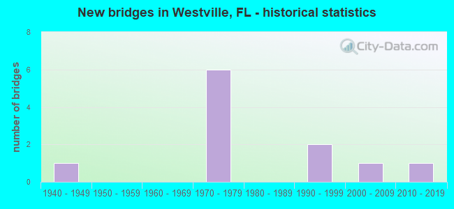
- New bridges - historical statistics
- 11940-1949
- 61970-1979
- 21990-1999
- 12000-2009
- 12010-2019


- Bridge Condition - Deck
- 66.7%Good
- 22.2%Satisfactory
- 11.1%Fair

- Bridge Condition - Superstructure
- 88.9%Good
- 11.1%Fair

- Bridge Condition - Substructure
- 44.4%Good
- 55.6%Satisfactory

- Bridge Condition - Channel
- 66.7%Good
- 22.2%Satisfactory
- 11.1%Fair
Find on map >> Show street view
Structure Number: 520034, Location: 4.9 Mi North of US90/SR10 (Lat: 30.810453, Lng: -85.914206), Route carried "on" structure: County highway 181, Year Built: 1940, Status: Open, Structure Length: 0.95m (3.12ft), Average Daily Traffic: 900 (year 2019), Truck Traffic: 11%, Average Future Daily Traffic: 990 (year 2039), Features Intersected: Thomas Bay
Minimum Vertical Clearance: 30+ m (98+ ft), Kilometerpoint: 7.387, Lanes on structure: 2, Owner: County Highway Agency, Approaching Roadway Width: 6.1m (20.0ft), Material/Design: Concrete, Design/Construction: Culvert, Number Of Spans In Main Unit: 3, Length of Maximum Span: 3.3m (10.8ft)
Condition: Channel: Fair, Culverts: Fair, Operating Rating: 35.4 metric tons, Method Used To Determine Operating Rating: Allowable Stress (AS), Inventory Rating: 23.6 metric tons, Method Used To Determine Inventory Rating: Allowable Stress (AS), Structural Evaluation: Somewhat better than minimum adequacy, Waterway Adequacy: Equal to present desirable criteria, Approach Roadway Alignment: Equal to present desirable criteria, Designated Inspection Frequency: Every 24 months, Inspection Date: Febuary 2021
Find on map >> Show street view
Structure Number: 520048, Location: 0.7mi W. of Choctaw River (Lat: 30.753547, Lng: -85.843311), Route carried "on" structure: Interstate 10, Year Built: 1973, Status: Open, Structure Length: 18.82m (61.75ft), Average Daily Traffic: 10,250 (year 2020), Truck Traffic: 33%, Average Future Daily Traffic: 17,784 (year 2042), Design Load: HS 20, Features Intersected: Choctawhatchee Relief
Minimum Vertical Clearance: 30+ m (98+ ft), Kilometerpoint: 12.348, Lanes on structure: 2, Base Highway Network: Yes, Owner: State Highway Agency, Approaching Roadway Width: 11.6m (38.1ft), Material/Design: Prestressed concrete, Design/Construction: Stringer/Multi-beam, Number Of Spans In Main Unit: 10, Length of Maximum Span: 18.8m (61.7ft), Curb-To-Curb Width: 12.2m (40.0ft), Out-to-Out Width: 13.1m (43.0ft)
Condition: Deck: Good, Superstructure: Good, Substructure: Satisfactory, Channel: Good, Operating Rating: 83.5 metric tons, Method Used To Determine Operating Rating: Load Factor (LF), Inventory Rating: 49.9 metric tons, Method Used To Determine Inventory Rating: Load Factor (LF), Structural Evaluation: Equal to present minimum criteria, Deck Geometry: Better than present minimum criteria, Waterway Adequacy: Equal to present desirable criteria, Approach Roadway Alignment: Equal to present desirable criteria, Designated Inspection Frequency: Every 24 months, Inspection Date: July 2021, Deck Structure Type: Concrete Cast-file-Place
Find on map >> Show street view
Structure Number: 520055, Location: 0.7mi W OF Choctaw. River (Lat: 30.753772, Lng: -85.843450), Route carried "on" structure: Interstate 10, Year Built: 1973, Status: Open, Structure Length: 18.82m (61.75ft), Average Daily Traffic: 10,250 (year 2020), Truck Traffic: 33%, Average Future Daily Traffic: 17,784 (year 2042), Design Load: HS 20, Features Intersected: Choctawhatchee Relief
Minimum Vertical Clearance: 30+ m (98+ ft), Kilometerpoint: 12.348, Lanes on structure: 2, Base Highway Network: Yes, Owner: State Highway Agency, Approaching Roadway Width: 11.6m (38.1ft), Material/Design: Prestressed concrete, Design/Construction: Stringer/Multi-beam, Number Of Spans In Main Unit: 10, Length of Maximum Span: 18.8m (61.7ft), Curb-To-Curb Width: 12.2m (40.0ft), Out-to-Out Width: 13.1m (43.0ft)
Condition: Deck: Good, Superstructure: Good, Substructure: Satisfactory, Channel: Good, Operating Rating: 83.5 metric tons, Method Used To Determine Operating Rating: Load Factor (LF), Inventory Rating: 49.9 metric tons, Method Used To Determine Inventory Rating: Load Factor (LF), Structural Evaluation: Equal to present minimum criteria, Deck Geometry: Better than present minimum criteria, Waterway Adequacy: Equal to present desirable criteria, Approach Roadway Alignment: Equal to present desirable criteria, Designated Inspection Frequency: Every 24 months, Inspection Date: July 2021, Deck Structure Type: Concrete Cast-file-Place
Find on map >> Show street view
Structure Number: 520058, Location: 5.7 Miles East of SR81 (Lat: 30.752375, Lng: -85.851422), Route carried "on" structure: County highway 181, Year Built: 1974, Status: Open, Structure Length: 7.19m (23.59ft), Average Daily Traffic: 550 (year 2020), Truck Traffic: 12%, Average Future Daily Traffic: 954 (year 2042), Design Load: HS 20+Mod, Features Intersected: I10 SR8
Minimum Vertical Clearance: 30+ m (98+ ft), Kilometerpoint: 6.186, Lanes on structure: 2, Lanes under structure: 4, Owner: State Highway Agency, Approaching Roadway Width: 6.1m (20.0ft), Material/Design: Prestressed concrete, Design/Construction: Stringer/Multi-beam, Number Of Spans In Main Unit: 4, Length of Maximum Span: 26.8m (87.9ft), Curb-To-Curb Width: 13.4m (44.0ft), Out-to-Out Width: 14.1m (46.3ft)
Condition: Deck: Good, Superstructure: Good, Substructure: Good, Operating Rating: 85.3 metric tons, Method Used To Determine Operating Rating: Load Factor (LF), Inventory Rating: 50.8 metric tons, Method Used To Determine Inventory Rating: Load Factor (LF), Structural Evaluation: Better than present minimum criteria, Deck Geometry: Superior to present desirable criteria, Underclear: Meets minimum limits, Approach Roadway Alignment: Equal to present desirable criteria, Designated Inspection Frequency: Every 24 months, Inspection Date: July 2021, Deck Structure Type: Concrete Cast-file-Place
Find on map >> Show street view
Structure Number: 520146, Location: 0.37MI East of CR181 N (Lat: 30.775297, Lng: -85.845083), Route carried "on" structure: US 90, Year Built: 1999, Status: Open, Structure Length: 18.29m (60.01ft), Average Daily Traffic: 3,200 (year 2020), Truck Traffic: 8%, Average Future Daily Traffic: 5,552 (year 2042), Design Load: HL 93, Features Intersected: Buckhead Slu
Minimum Vertical Clearance: 30+ m (98+ ft), Kilometerpoint: 21.205, Lanes on structure: 2, Base Highway Network: Yes, Owner: State Highway Agency, Approaching Roadway Width: 10.4m (34.1ft), Skew: 1 degrees, Material/Design: Prestressed concrete, Design/Construction: Stringer/Multi-beam, Number Of Spans In Main Unit: 12, Length of Maximum Span: 15.2m (49.9ft), Curb-To-Curb Width: 13.4m (44.0ft), Out-to-Out Width: 14.0m (45.9ft)
Condition: Deck: Good, Superstructure: Good, Substructure: Good, Channel: Good, Operating Rating: 49.0 metric tons, Method Used To Determine Operating Rating: Load and Resistance Factor (LRFR), Inventory Rating: 37.8 metric tons, Method Used To Determine Inventory Rating: Load and Resistance Factor (LRFR), Structural Evaluation: Better than present minimum criteria, Deck Geometry: Better than present minimum criteria, Waterway Adequacy: Superior to present desirable criteria, Approach Roadway Alignment: Equal to present desirable criteria, Designated Inspection Frequency: Every 24 months, Underwater Inspection Frequency: Every 24 months, Inspection Date: March 2021, Underwater Inspection Date: March 2021, Deck Structure Type: Concrete Cast-file-Place
Find on map >> Show street view
Structure Number: 520147, Location: 2.7 Mi East of Westville (Lat: 30.777786, Lng: -85.840100), Route carried "on" structure: US 90, Year Built: 1999, Status: Open, Structure Length: 18.59m (60.99ft), Average Daily Traffic: 3,200 (year 2020), Truck Traffic: 8%, Average Future Daily Traffic: 5,552 (year 2042), Design Load: HL 93, Features Intersected: Choct. River Relief
Minimum Vertical Clearance: 30+ m (98+ ft), Kilometerpoint: 21.665, Lanes on structure: 2, Base Highway Network: Yes, Owner: State Highway Agency, Approaching Roadway Width: 10.4m (34.1ft), Material/Design: Prestressed concrete, Design/Construction: Stringer/Multi-beam, Number Of Spans In Main Unit: 12, Length of Maximum Span: 15.5m (50.9ft), Curb-To-Curb Width: 13.4m (44.0ft), Out-to-Out Width: 14.0m (45.9ft)
Condition: Deck: Good, Superstructure: Good, Substructure: Good, Channel: Good, Operating Rating: 50.7 metric tons, Method Used To Determine Operating Rating: Load and Resistance Factor (LRFR), Inventory Rating: 39.1 metric tons, Method Used To Determine Inventory Rating: Load and Resistance Factor (LRFR), Structural Evaluation: Better than present minimum criteria, Deck Geometry: Better than present minimum criteria, Waterway Adequacy: Better than present minimum criteria, Approach Roadway Alignment: Equal to present desirable criteria, Designated Inspection Frequency: Every 24 months, Inspection Date: March 2021, Deck Structure Type: Concrete Cast-file-Place
Find on map >> Show street view
Structure Number: 520149, Location: Holmes/Washington Co. LN (Lat: 30.775831, Lng: -85.827283), Route carried "on" structure: US 90, Year Built: 2001, Status: Open, Structure Length: 95.00m (311.68ft), Average Daily Traffic: 3,200 (year 2020), Truck Traffic: 8%, Average Future Daily Traffic: 5,552 (year 2042), Design Load: HS 20, Features Intersected: Choctawhatchee River
Minimum Vertical Clearance: 30+ m (98+ ft), Kilometerpoint: 22.579, Lanes on structure: 2, Base Highway Network: Yes, Owner: State Highway Agency, Approaching Roadway Width: 9.8m (32.2ft), Material/Design: Prestressed concrete, Design/Construction: Stringer/Multi-beam, Number Of Spans In Main Unit: 25, Length of Maximum Span: 38.0m (124.7ft), Curb-To-Curb Width: 13.2m (43.3ft), Out-to-Out Width: 14.1m (46.3ft)
Condition: Deck: Fair, Superstructure: Fair, Substructure: Satisfactory, Channel: Good, Operating Rating: 79.4 metric tons, Method Used To Determine Operating Rating: Load Factor (LF), Inventory Rating: 47.6 metric tons, Method Used To Determine Inventory Rating: Load Factor (LF), Structural Evaluation: Somewhat better than minimum adequacy, Deck Geometry: Equal to present minimum criteria, Waterway Adequacy: Meets minimum limits, Approach Roadway Alignment: Equal to present desirable criteria, Designated Inspection Frequency: Every 24 months, Underwater Inspection Frequency: Every 24 months, Inspection Date: March 2020, Underwater Inspection Date: March 2020, Deck Structure Type: Concrete Cast-file-Place
Find on map >> Show street view
Structure Number: 610047, Location: 1.0 Mile West of CR279 (Lat: 30.755811, Lng: -85.829578), Route carried "on" structure: Interstate 10, Year Built: 1973, Status: Open, Structure Length: 60.96m (200.00ft), Average Daily Traffic: 10,250 (year 2020), Truck Traffic: 33%, Average Future Daily Traffic: 17,784 (year 2042), Design Load: HS 20, Features Intersected: Choctawhatchee River
Minimum Vertical Clearance: 30+ m (98+ ft), Kilometerpoint: 0.000, Lanes on structure: 2, Base Highway Network: Yes, Owner: State Highway Agency, Approaching Roadway Width: 11.6m (38.1ft), Skew: 2 degrees, Navigation Control: Yes ( Vertical Clearance: 13.7m (44.9ft), Horizontal Clearance: 28.0m (91.9ft)), Material/Design: Prestressed concrete, Design/Construction: Stringer/Multi-beam, Number Of Spans In Main Unit: 23, Length of Maximum Span: 34.1m (111.9ft), Curb-To-Curb Width: 12.2m (40.0ft), Out-to-Out Width: 13.1m (43.0ft)
Condition: Deck: Satisfactory, Superstructure: Good, Substructure: Satisfactory, Channel: Satisfactory, Operating Rating: 79.8 metric tons, Method Used To Determine Operating Rating: Load Factor (LF), Inventory Rating: 48.1 metric tons, Method Used To Determine Inventory Rating: Load Factor (LF), Structural Evaluation: Equal to present minimum criteria, Deck Geometry: Better than present minimum criteria, Waterway Adequacy: Equal to present desirable criteria, Approach Roadway Alignment: Equal to present desirable criteria, Designated Inspection Frequency: Every 24 months, Underwater Inspection Frequency: Every 24 months, Inspection Date: March 2021, Underwater Inspection Date: March 2021, Deck Structure Type: Concrete Cast-file-Place
Find on map >> Show street view
Structure Number: 610062, Location: 1.0 Mile West of CR279 (Lat: 30.755575, Lng: -85.829517), Route carried "on" structure: Interstate 10, Year Built: 1973, Status: Open, Structure Length: 60.96m (200.00ft), Average Daily Traffic: 10,250 (year 2020), Truck Traffic: 33%, Average Future Daily Traffic: 17,784 (year 2042), Design Load: HS 20, Features Intersected: Choctawhatchee River
Minimum Vertical Clearance: 30+ m (98+ ft), Kilometerpoint: 0.000, Lanes on structure: 2, Base Highway Network: Yes, Owner: State Highway Agency, Approaching Roadway Width: 11.6m (38.1ft), Skew: 2 degrees, Navigation Control: Yes ( Vertical Clearance: 13.7m (44.9ft), Horizontal Clearance: 28.0m (91.9ft)), Material/Design: Prestressed concrete, Design/Construction: Stringer/Multi-beam, Number Of Spans In Main Unit: 23, Length of Maximum Span: 34.1m (111.9ft), Curb-To-Curb Width: 12.2m (40.0ft), Out-to-Out Width: 12.9m (42.3ft)
Condition: Deck: Satisfactory, Superstructure: Good, Substructure: Satisfactory, Channel: Satisfactory, Operating Rating: 79.8 metric tons, Method Used To Determine Operating Rating: Load Factor (LF), Inventory Rating: 48.1 metric tons, Method Used To Determine Inventory Rating: Load Factor (LF), Structural Evaluation: Equal to present minimum criteria, Deck Geometry: Better than present minimum criteria, Waterway Adequacy: Equal to present desirable criteria, Approach Roadway Alignment: Equal to present desirable criteria, Designated Inspection Frequency: Every 24 months, Underwater Inspection Frequency: Every 24 months, Inspection Date: March 2021, Underwater Inspection Date: March 2021, Deck Structure Type: Concrete Cast-file-Place
Find on map >> Show street view
Structure Number: 61416, Location: 1.89 MI S of CR 279 (Lat: 30.716583, Lng: -85.799611), Route carried "on" structure: County highway , Year Built: 2013, Status: Open, Structure Length: 4.39m (14.40ft), Average Daily Traffic: 900 (year 2020), Truck Traffic: 2%, Average Future Daily Traffic: 990 (year 2042), Design Load: HL 93, Features Intersected: Gum Creek, Facility Carried by Structure: River Road
Minimum Vertical Clearance: 30+ m (98+ ft), Kilometerpoint: 6.207, Lanes on structure: 2, Owner: County Highway Agency, Approaching Roadway Width: 6.1m (20.0ft), Material/Design: Concrete continuous, Design/Construction: Slab, Number Of Spans In Main Unit: 4, Length of Maximum Span: 11.0m (36.1ft), Curb-To-Curb Width: 7.2m (23.6ft), Out-to-Out Width: 8.2m (26.9ft)
Condition: Deck: Good, Superstructure: Good, Substructure: Good, Channel: Good, Operating Rating: 57.5 metric tons, Method Used To Determine Operating Rating: Load and Resistance Factor (LRFR), Inventory Rating: 44.5 metric tons, Method Used To Determine Inventory Rating: Load and Resistance Factor (LRFR), Structural Evaluation: Better than present minimum criteria, Deck Geometry: Meets minimum limits, Waterway Adequacy: Better than present minimum criteria, Approach Roadway Alignment: Equal to present desirable criteria, Designated Inspection Frequency: Every 24 months, Inspection Date: Febuary 2022, Deck Structure Type: Concrete Cast-file-Place
Find on map >> Show street view
Structure Number: 520058, Location: 5.7 Miles East of SR81 (Lat: 30.752375, Lng: -85.851422), Route carried "under" structure: Interstate 10, Year Built: 1974, Structure Length: 0. m, Average Daily Traffic: 20,500 (year 2020), Truck Traffic: 33%, Features Intersected: I10 SR8, Facility Carried by Structure: CR181
Minimum Vertical Clearance: 4.97m (16.31ft), Kilometerpoint: 11.647, Lanes on structure: 2, Lanes under structure: 4, Material/Design: Prestressed concrete, Design/Construction: Stringer/Multi-beam, Length of Maximum Span: 26.8m (87.9ft)