Bridge Statistics for Westover, West Virginia (WV)
Condition, Traffic, Stress, Structural Evaluation, Project Costs
- National Bridge Inventory (NBI) Statistics
- 10Number of bridges
- 154ft / 47.1mTotal length
- $7,617,000Total costs
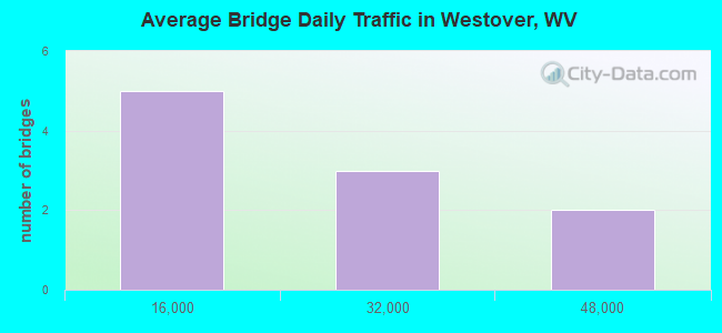
- 166,350Total average daily traffic
- 25,241Total average daily truck traffic
- National Bridge Inventory (NBI) Registered Bridges for Westover
- No street view available for this location
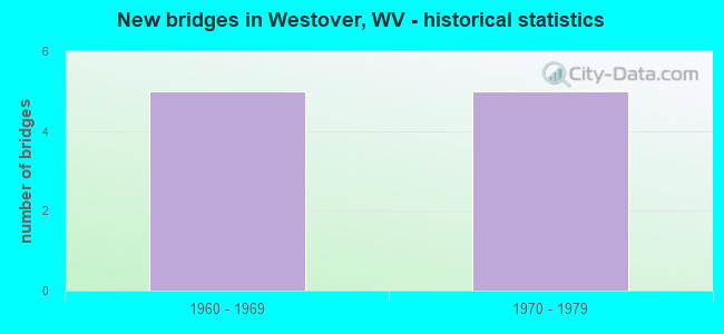
- New bridges - historical statistics
- 51960-1969
- 51970-1979
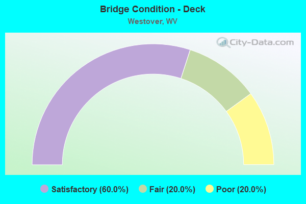
- Bridge Condition - Deck
- 60.0%Satisfactory
- 20.0%Fair
- 20.0%Poor
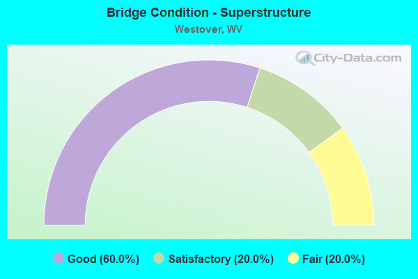
- Bridge Condition - Superstructure
- 60.0%Good
- 20.0%Satisfactory
- 20.0%Fair
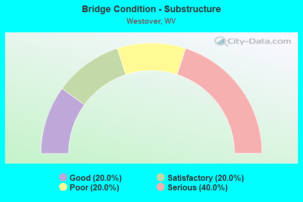
- Bridge Condition - Substructure
- 20.0%Good
- 20.0%Satisfactory
- 20.0%Poor
- 40.0%Serious
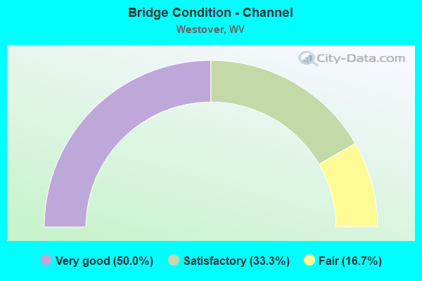
- Bridge Condition - Channel
- 50.0%Very good
- 33.3%Satisfactory
- 16.7%Fair
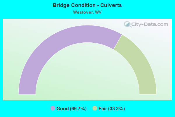
- Bridge Condition - Culverts
- 66.7%Good
- 33.3%Fair
Find on map >> Show street view
Structure Number: 31A049, Location: 0.02 MI NORTH US RT 19 (Lat: 39.628831, Lng: -79.988481), Route carried "on" structure: Ramp Interstate 7900, Year Built: 1971, Status: Open, Structure Length: 7.24m (23.75ft), Average Daily Traffic: 6,500 (year 2019), Truck Traffic: 16%, Average Future Daily Traffic: 9,300 (year 2041), Design Load: HS 20, Features Intersected: DENTS RUN, Facility Carried by Structure: I 79 NB ON RAMP
Minimum Vertical Clearance: 30+ m (98+ ft), Kilometerpoint: 245.747, Lanes on structure: 1, Owner: State Highway Agency, Approaching Roadway Width: 8.5m (27.9ft), Skew: 4 degrees, Material/Design: Steel continuous, Design/Construction: Stringer/Multi-beam, Number Of Spans In Main Unit: 1, Number Of Approach Spans: 2, Length of Maximum Span: 28.0m (91.9ft), Curb-To-Curb Width: 8.1m (26.6ft), Out-to-Out Width: 9.3m (30.5ft)
Condition: Deck: Poor, Superstructure: Good, Substructure: Poor, Channel: Very good, Operating Rating: 57.1 metric tons, Method Used To Determine Operating Rating: Load Factor (LF), Inventory Rating: 34.5 metric tons, Method Used To Determine Inventory Rating: Load Factor (LF), Structural Evaluation: Meets minimum limits, Deck Geometry: Superior to present desirable criteria, Waterway Adequacy: Equal to present desirable criteria, Approach Roadway Alignment: Better than present minimum criteria, Length Of Structure Improvement: 7.25m (23.79ft), Designated Inspection Frequency: Every 24 months, Inspection Date: March 2021, Bridge Improvement Cost: $307,000, Roadway Improvement Cost: $108,000, Total Project Cost: $451,000 ( Estimate for 2021), Deck Structure Type: Concrete Cast-file-Place, Wearing Surface/Protective System: Wearing Surface: Monolithic Concrete
Find on map >> Show street view
Structure Number: 31A05, Location: 0.04 MI SOUTH I-79 RAMP (Lat: 39.627719, Lng: -79.988150), Route carried "on" structure: US 1900, Year Built: 1969, Status: Open, Structure Length: 1.59m (5.22ft), Average Daily Traffic: 16,100 (year 2019), Truck Traffic: 6%, Average Future Daily Traffic: 20,290 (year 2041), Design Load: HS 20, Features Intersected: DENTS RUN, Facility Carried by Structure: US ROUTE 19
Minimum Vertical Clearance: 30+ m (98+ ft), Kilometerpoint: 14.677, Lanes on structure: 5, Base Highway Network: Yes, Owner: State Highway Agency, Approaching Roadway Width: 26.8m (87.9ft), Skew: 5 degrees, Material/Design: Concrete continuous, Design/Construction: Culvert, Number Of Spans In Main Unit: 2, Length of Maximum Span: 7.7m (25.3ft)
Condition: Channel: Satisfactory, Culverts: Fair, Operating Rating: 71.7 metric tons, Method Used To Determine Operating Rating: Field evaluation and documented engineering judgment, Inventory Rating: 32.7 metric tons, Method Used To Determine Inventory Rating: Field evaluation and documented engineering judgment, Structural Evaluation: Somewhat better than minimum adequacy, Waterway Adequacy: Superior to present desirable criteria, Approach Roadway Alignment: Equal to present desirable criteria, Designated Inspection Frequency: Every 24 months, Inspection Date: June 2021
Find on map >> Show street view
Structure Number: 31A064, Location: 0.15 MI SOUTH US RT 19 (Lat: 39.622839, Lng: -79.989119), Route carried "on" structure: County highway 1918, Year Built: 1965, Status: Open, Structure Length: 0.97m (3.18ft), Average Daily Traffic: 50 (year 2018), Average Future Daily Traffic: 70 (year 2038), Features Intersected: DENTS RUN, Facility Carried by Structure: MON CO RT 19/18
Minimum Vertical Clearance: 30+ m (98+ ft), Kilometerpoint: 0.241, Lanes on structure: 2, Owner: State Highway Agency, Approaching Roadway Width: 5.5m (18.0ft), Skew: 1 degrees, Material/Design: Steel, Design/Construction: Stringer/Multi-beam, Number Of Spans In Main Unit: 1, Length of Maximum Span: 8.7m (28.5ft), Curb-To-Curb Width: 5.4m (17.7ft), Out-to-Out Width: 5.9m (19.4ft)
Condition: Deck: Satisfactory, Superstructure: Good, Substructure: Good, Channel: Fair, Operating Rating: 56.2 metric tons, Method Used To Determine Operating Rating: Load Factor (LF), Inventory Rating: 34.5 metric tons, Method Used To Determine Inventory Rating: Load Factor (LF), Structural Evaluation: Better than present minimum criteria, Deck Geometry: High priority of corrective action, Waterway Adequacy: Equal to present minimum criteria, Approach Roadway Alignment: Equal to present minimum criteria, Length Of Structure Improvement: 1.68m (5.51ft), Designated Inspection Frequency: Every 24 months, Inspection Date: Febuary 2020, Bridge Improvement Cost: $248,000, Roadway Improvement Cost: $211,000, Total Project Cost: $494,000 ( Estimate for 2020), Deck Structure Type: Concrete Cast-file-Place, Wearing Surface/Protective System: Wearing Surface: Bituminous
Find on map >> Show street view
Structure Number: 31A114, Location: 0.10 MI EAST CO RT 45/15 (Lat: 39.604839, Lng: -79.992850), Route carried "on" structure: County highway 4500, Year Built: 1971, Status: Open, Structure Length: 7.03m (23.06ft), Average Daily Traffic: 3,800 (year 2019), Truck Traffic: 6%, Average Future Daily Traffic: 5,890 (year 2041), Design Load: HS 20, Features Intersected: I-79 NB and SB, Facility Carried by Structure: MON. CO. RT. 45
Minimum Vertical Clearance: 30+ m (98+ ft), Kilometerpoint: 16.206, Lanes on structure: 2, Lanes under structure: 4, Owner: State Highway Agency, Approaching Roadway Width: 12.8m (42.0ft), Material/Design: Steel, Design/Construction: Arch - Deck, Number Of Spans In Main Unit: 1, Number Of Approach Spans: 2, Length of Maximum Span: 48.8m (160.1ft), Curb-To-Curb Width: 13.0m (42.7ft), Out-to-Out Width: 14.2m (46.6ft)
Condition: Deck: Satisfactory, Superstructure: Fair, Substructure: Satisfactory, Operating Rating: 61.7 metric tons, Method Used To Determine Operating Rating: Load Factor (LF), Inventory Rating: 32.7 metric tons, Method Used To Determine Inventory Rating: Load Factor (LF), Structural Evaluation: Somewhat better than minimum adequacy, Deck Geometry: Equal to present minimum criteria, Underclear: Better than present minimum criteria, Approach Roadway Alignment: Better than present minimum criteria, Length Of Structure Improvement: 7.04m (23.10ft), Designated Inspection Frequency: Every 24 months, Critical Feature Inspection Frequency: Every 24 months, Inspection Date: May 2021, Critical Feature Inspection Date: May 2021, Bridge Improvement Cost: $378,000, Roadway Improvement Cost: $93,000, Total Project Cost: $654,000 ( Estimate for 2021), Deck Structure Type: Concrete Cast-file-Place, Wearing Surface/Protective System: Wearing Surface: Monolithic Concrete
Find on map >> Show street view
Structure Number: 31A128, Location: 0.47 MI NORTH US ROUTE 19 (Lat: 39.633911, Lng: -79.993269), Route carried "on" structure: County highway 4900, Year Built: 1969, Status: Open, Structure Length: 1.15m (3.77ft), Average Daily Traffic: 3,100 (year 2019), Truck Traffic: 6%, Average Future Daily Traffic: 4,225 (year 2039), Design Load: HS 20, Features Intersected: DENTS RUN, Facility Carried by Structure: MON CO RT 49
Minimum Vertical Clearance: 30+ m (98+ ft), Kilometerpoint: 0.756, Lanes on structure: 2, Owner: State Highway Agency, Approaching Roadway Width: 12.2m (40.0ft), Skew: 3 degrees, Material/Design: Concrete continuous, Design/Construction: Culvert, Number Of Spans In Main Unit: 2, Length of Maximum Span: 5.5m (18.0ft)
Condition: Channel: Satisfactory, Culverts: Good, Operating Rating: 71.7 metric tons, Method Used To Determine Operating Rating: Field evaluation and documented engineering judgment, Inventory Rating: 32.7 metric tons, Method Used To Determine Inventory Rating: Field evaluation and documented engineering judgment, Structural Evaluation: Better than present minimum criteria, Waterway Adequacy: Equal to present desirable criteria, Approach Roadway Alignment: Equal to present desirable criteria, Designated Inspection Frequency: Every 48 months, Inspection Date: Febuary 2021
Find on map >> Show street view
Structure Number: 31A171, Location: 2.12 MI SOUTH US RT 19 (Lat: 39.597811, Lng: -79.987611), Route carried "on" structure: Interstate 7900, Year Built: 1969, Status: Open, Structure Length: 0.73m (2.40ft), Average Daily Traffic: 47,600 (year 2019), Truck Traffic: 16%, Average Future Daily Traffic: 68,000 (year 2041), Design Load: HS 20, Features Intersected: Monongalia Co 45/9, Facility Carried by Structure: INTERSTATE 79
Minimum Vertical Clearance: 30+ m (98+ ft), Kilometerpoint: 242.061, Lanes on structure: 5, Lanes under structure: 2, Base Highway Network: Yes, Owner: State Highway Agency, Approaching Roadway Width: 25.3m (83.0ft), Material/Design: Concrete, Design/Construction: Culvert, Number Of Spans In Main Unit: 1, Length of Maximum Span: 7.3m (24.0ft)
Condition: Culverts: Good, Operating Rating: 71.7 metric tons, Method Used To Determine Operating Rating: Field evaluation and documented engineering judgment, Inventory Rating: 32.7 metric tons, Method Used To Determine Inventory Rating: Field evaluation and documented engineering judgment, Structural Evaluation: Better than present minimum criteria, Underclear: High priority of replacement, Approach Roadway Alignment: Equal to present desirable criteria, Length Of Structure Improvement: 1.31m (4.30ft), Designated Inspection Frequency: Every 24 months, Inspection Date: March 2021, Bridge Improvement Cost: $802,000, Roadway Improvement Cost: $751,000, Total Project Cost: $1,828,000 ( Estimate for 2021)
Find on map >> Show street view
Structure Number: 31A172, Location: 2.34 MI SOUTH CO RT 19/24 (Lat: 39.626800, Lng: -79.988619), Route carried "on" structure: Interstate 7900, Year Built: 1971, Status: Open, Structure Length: 14.18m (46.52ft), Average Daily Traffic: 21,050 (year 2019), Truck Traffic: 16%, Average Future Daily Traffic: 30,100 (year 2041), Design Load: HS 20, Features Intersected: US 19, Facility Carried by Structure: INTERSTATE 79 SB
Minimum Vertical Clearance: 30+ m (98+ ft), Kilometerpoint: 245.473, Lanes on structure: 3, Lanes under structure: 5, Base Highway Network: Yes, Owner: State Highway Agency, Approaching Roadway Width: 14.0m (45.9ft), Skew: 4 degrees, Material/Design: Steel, Design/Construction: Stringer/Multi-beam, Number Of Spans In Main Unit: 1, Number Of Approach Spans: 3, Length of Maximum Span: 47.3m (155.2ft), Curb-To-Curb Width: 16.6m (54.5ft), Out-to-Out Width: 17.9m (58.7ft)
Condition: Deck: Satisfactory, Superstructure: Good, Substructure: Serious, Channel: Very good, Operating Rating: 65.3 metric tons, Method Used To Determine Operating Rating: Load Factor (LF), Inventory Rating: 39.0 metric tons, Method Used To Determine Inventory Rating: Load Factor (LF), Structural Evaluation: High priority of corrective action, Deck Geometry: Equal to present minimum criteria, Underclear: Equal to present minimum criteria, Waterway Adequacy: Equal to present desirable criteria, Approach Roadway Alignment: Equal to present desirable criteria, Length Of Structure Improvement: 14.17m (46.49ft), Designated Inspection Frequency: Every 24 months, Other Special Inspection Frequency: Every 12 months, Inspection Date: September 2021, Other Special Inspection Date: September 2021, Bridge Improvement Cost: $1,521,000, Roadway Improvement Cost: $142,000, Total Project Cost: $2,057,000 ( Estimate for 2021), Deck Structure Type: Concrete Cast-file-Place, Wearing Surface/Protective System: Wearing Surface: Latex Concrete
Find on map >> Show street view
Structure Number: 31A215, Location: 2.34 MI SOUTH CO RT 19/24 (Lat: 39.627211, Lng: -79.988450), Route carried "on" structure: Interstate 7900, Year Built: 1971, Status: Open, Structure Length: 14.19m (46.56ft), Average Daily Traffic: 21,050 (year 2019), Truck Traffic: 16%, Average Future Daily Traffic: 30,100 (year 2041), Design Load: HS 20, Features Intersected: US 19 & Dents Run, Facility Carried by Structure: INTERSTATE 79 NB
Minimum Vertical Clearance: 30+ m (98+ ft), Kilometerpoint: 245.473, Lanes on structure: 2, Lanes under structure: 4, Base Highway Network: Yes, Owner: State Highway Agency, Approaching Roadway Width: 11.6m (38.1ft), Skew: 4 degrees, Material/Design: Steel, Design/Construction: Stringer/Multi-beam, Number Of Spans In Main Unit: 1, Number Of Approach Spans: 3, Length of Maximum Span: 44.4m (145.7ft), Curb-To-Curb Width: 12.3m (40.4ft), Out-to-Out Width: 13.6m (44.6ft)
Condition: Deck: Fair, Superstructure: Satisfactory, Substructure: Serious, Channel: Very good, Operating Rating: 65.3 metric tons, Method Used To Determine Operating Rating: Load Factor (LF), Inventory Rating: 39.0 metric tons, Method Used To Determine Inventory Rating: Load Factor (LF), Structural Evaluation: High priority of corrective action, Deck Geometry: Better than present minimum criteria, Underclear: Equal to present minimum criteria, Waterway Adequacy: Superior to present desirable criteria, Approach Roadway Alignment: Equal to present desirable criteria, Length Of Structure Improvement: 14.20m (46.59ft), Designated Inspection Frequency: Every 24 months, Other Special Inspection Frequency: Every 12 months, Inspection Date: September 2021, Other Special Inspection Date: September 2021, Bridge Improvement Cost: $1,541,000, Roadway Improvement Cost: $159,000, Total Project Cost: $2,133,000 ( Estimate for 2021), Deck Structure Type: Concrete Cast-file-Place, Wearing Surface/Protective System: Wearing Surface: Bituminous
Find on map >> Show street view
Structure Number: 31A114, Location: 0.10 MI EAST CO RT 45/15 (Lat: 39.604839, Lng: -79.992850), Route carried "under" structure: Interstate 7900, Year Built: 1971, Structure Length: 0. m, Average Daily Traffic: 47,050 (year 0017), Truck Traffic: 18%, Features Intersected: I-79 NB and SB, Facility Carried by Structure: MON. CO. RT. 45
Minimum Vertical Clearance: 8.69m (28.51ft), Kilometerpoint: 242.979, Lanes on structure: 2, Lanes under structure: 4, Length of Maximum Span: 48.8m (160.1ft)
Find on map >> Show street view
Structure Number: 31A171, Location: 2.12 MI SOUTH US RT 19 (Lat: 39.597811, Lng: -79.987611), Route carried "under" structure: County highway 4509, Year Built: 1969, Structure Length: 0. m, Average Daily Traffic: 50 (year 0017), Features Intersected: Monongalia Co 45/9, Facility Carried by Structure: INTERSTATE 79
Minimum Vertical Clearance: 4.22m (13.85ft), Kilometerpoint: 0.933, Lanes on structure: 5, Lanes under structure: 2, Length of Maximum Span: 7.3m (24.0ft)