Bridge Statistics for Westminster, Massachusetts (MA)
Condition, Traffic, Stress, Structural Evaluation, Project Costs
- National Bridge Inventory (NBI) Statistics
- 19Number of bridges
- 148ft / 44.8mTotal length
- $21,927,000Total costs
- 145,582Total average daily traffic
- 11,410Total average daily truck traffic
- National Bridge Inventory (NBI) Registered Bridges for Westminster
- No street view available for this location
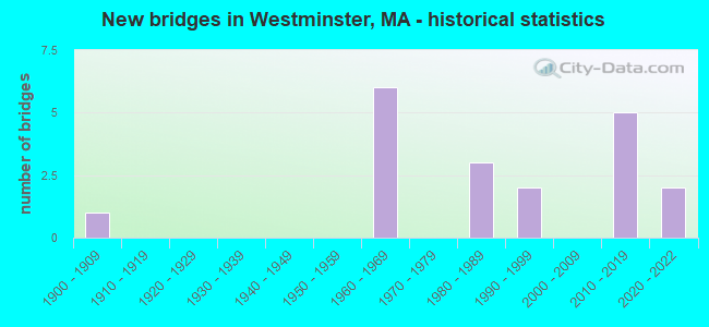
- New bridges - historical statistics
- 11900-1909
- 61960-1969
- 31980-1989
- 21990-1999
- 52010-2019
- 22020-2022
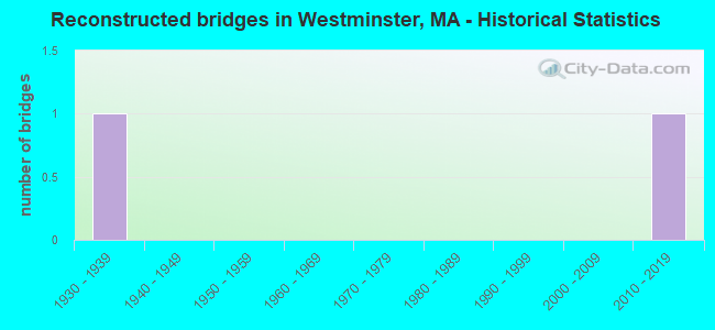
- Reconstructed bridges - Historical Statistics
- 11930-1939
- 01940-1949
- 01950-1959
- 01960-1969
- 01970-1979
- 01980-1989
- 01990-1999
- 02000-2009
- 12010-2019
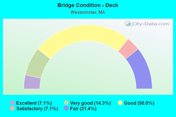
- Bridge Condition - Deck
- 7.1%Excellent
- 14.3%Very good
- 50.0%Good
- 7.1%Satisfactory
- 21.4%Fair
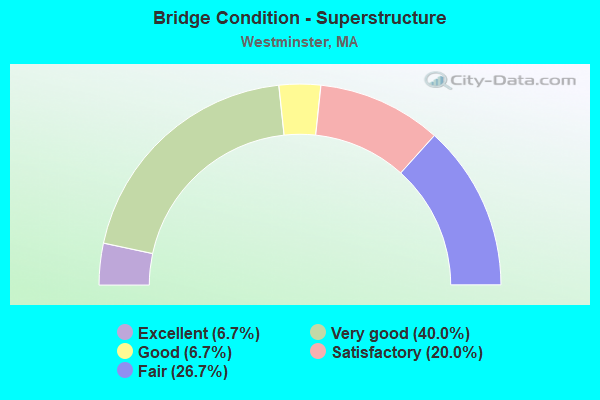
- Bridge Condition - Superstructure
- 6.7%Excellent
- 40.0%Very good
- 6.7%Good
- 20.0%Satisfactory
- 26.7%Fair
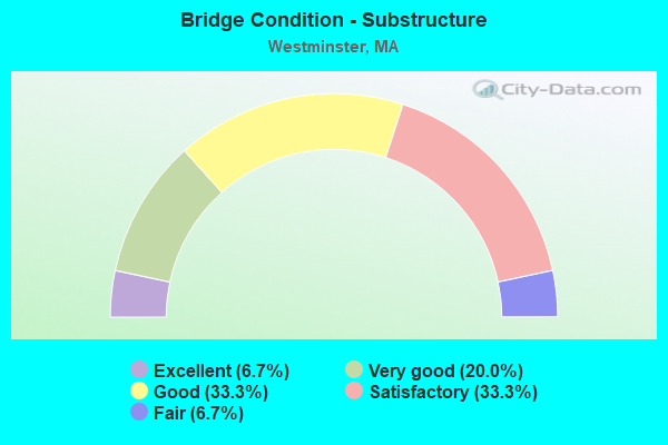
- Bridge Condition - Substructure
- 6.7%Excellent
- 20.0%Very good
- 33.3%Good
- 33.3%Satisfactory
- 6.7%Fair
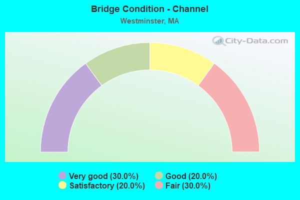
- Bridge Condition - Channel
- 30.0%Very good
- 20.0%Good
- 20.0%Satisfactory
- 30.0%Fair
Find on map >> Show street view
Structure Number: W280031KNDOTNBI, Location: .25 MI W. OF FITCHBURG TL (Lat: 42.559972, Lng: -71.866714), Route carried "on" structure: Alternate State highway 2A, Year Built: 1992, Status: Open, Structure Length: 2.26m (7.41ft), Average Daily Traffic: 6,215 (year 2020), Truck Traffic: 10%, Average Future Daily Traffic: 15,793 (year 2032), Design Load: HS 20, Features Intersected: WATER WHITMAN RIVER, Facility Carried by Structure: ST 2 A/STATE RD E
Minimum Vertical Clearance: 30+ m (98+ ft), Kilometerpoint: 74.234, Lanes on structure: 2, Base Highway Network: Yes, Owner: State Highway Agency, Approaching Roadway Width: 11.0m (36.1ft), Skew: 2 degrees, Material/Design: Steel, Design/Construction: Stringer/Multi-beam, Number Of Spans In Main Unit: 1, Length of Maximum Span: 20.4m (66.9ft), Curb or Sidewalk Widths: Left: 1.5m (4.9ft), Right: 0.0m, Curb-To-Curb Width: 11.0m (36.1ft), Out-to-Out Width: 13.6m (44.6ft)
Condition: Deck: Good, Superstructure: Very good, Substructure: Good, Channel: Fair, Operating Rating: 79.2 metric tons, Method Used To Determine Operating Rating: Load Factor (LF), Inventory Rating: 47.5 metric tons, Method Used To Determine Inventory Rating: Load Factor (LF), Structural Evaluation: Better than present minimum criteria, Waterway Adequacy: Equal to present desirable criteria, Approach Roadway Alignment: Equal to present desirable criteria, Length Of Structure Improvement: 3.10m (10.17ft), Designated Inspection Frequency: Every 24 months, Inspection Date: October 2021, Bridge Improvement Cost: $2,599,000, Roadway Improvement Cost: $260,000, Total Project Cost: $3,899,000 ( Estimate for 2022), Deck Structure Type: Concrete Cast-file-Place, Wearing Surface/Protective System: Wearing Surface: Bituminous, Membrane: Built-up, Deck Protection: Epoxy Coated Reinforcing
Find on map >> Show street view
Structure Number: W280041JCMUNNBI, Location: .1 MI. NE. OF RT. 12 (Lat: 42.607817, Lng: -71.869036), Route carried "on" structure: City street , Year Built: 1988, Status: Open, Structure Length: 1.28m (4.20ft), Average Daily Traffic: 150 (year 2014), Truck Traffic: 1%, Average Future Daily Traffic: 237 (year 2031), Design Load: H 20, Features Intersected: WATER PHILLIPS BROOK, Facility Carried by Structure: HWY FRED SMTH RD
Minimum Vertical Clearance: 30+ m (98+ ft), Kilometerpoint: 0.129, Lanes on structure: 2, Owner: Town or Township Highway Agency, Approaching Roadway Width: 7.0m (23.0ft), Material/Design: Concrete, Design/Construction: Culvert, Number Of Spans In Main Unit: 3, Length of Maximum Span: 3.7m (12.1ft), Curb-To-Curb Width: 8.5m (27.9ft), Out-to-Out Width: 9.8m (32.2ft)
Condition: Channel: Satisfactory, Culverts: Fair, Operating Rating: 66.0 metric tons, Method Used To Determine Operating Rating: Allowable Stress (AS), Inventory Rating: 38.9 metric tons, Method Used To Determine Inventory Rating: Allowable Stress (AS), Structural Evaluation: Somewhat better than minimum adequacy, Deck Geometry: Equal to present minimum criteria, Waterway Adequacy: Equal to present desirable criteria, Approach Roadway Alignment: Better than present minimum criteria, Length Of Structure Improvement: 0.90m (2.95ft), Designated Inspection Frequency: Every 24 months, Inspection Date: August 2020, Bridge Improvement Cost: $453,000, Roadway Improvement Cost: $46,000, Total Project Cost: $680,000 ( Estimate for 2022)
Find on map >> Show street view
Structure Number: W280075VXDOTNBI, Location: .5 MI N OF FTCHBRG TL (Lat: 42.598511, Lng: -71.864008), Route carried "on" structure: State highway 12, Year Built: 2010, Status: Open, Structure Length: 2.10m (6.89ft), Average Daily Traffic: 3,506 (year 2019), Truck Traffic: 10%, Average Future Daily Traffic: 11,434 (year 2032), Design Load: HS 20, Features Intersected: WATER PHILLIPS BROOK
Minimum Vertical Clearance: 30+ m (98+ ft), Kilometerpoint: 79.419, Lanes on structure: 2, Base Highway Network: Yes, Owner: State Highway Agency, Approaching Roadway Width: 10.0m (32.8ft), Skew: 3 degrees, Material/Design: Prestressed concrete, Design/Construction: Box Beam or Girders - Single/Spread, Number Of Spans In Main Unit: 1, Length of Maximum Span: 19.4m (63.6ft), Curb or Sidewalk Widths: Left: 0.0m, Right: 1.8m (5.9ft), Curb-To-Curb Width: 10.0m (32.8ft), Out-to-Out Width: 12.7m (41.7ft)
Condition: Deck: Very good, Superstructure: Very good, Substructure: Very good, Channel: Very good, Inventory Rating: 70.8 metric tons, Method Used To Determine Inventory Rating: Load Factor (LF), Structural Evaluation: Equal to present desirable criteria, Deck Geometry: Meets minimum limits, Waterway Adequacy: Equal to present desirable criteria, Approach Roadway Alignment: Equal to present desirable criteria, Length Of Structure Improvement: 2.10m (6.89ft), Designated Inspection Frequency: Every 24 months, Inspection Date: October 2021, Bridge Improvement Cost: $674,000, Roadway Improvement Cost: $68,000, Total Project Cost: $1,012,000 ( Estimate for 2022), Deck Structure Type: Concrete Cast-file-Place, Wearing Surface/Protective System: Wearing Surface: Bituminous, Membrane: Built-up, Deck Protection: Epoxy Coated Reinforcing
Find on map >> Show street view
Structure Number: W280091J9MUNNBI, Location: 0.1MI W OF ST-12 (Lat: 42.591247, Lng: -71.861039), Route carried "on" structure: City street , Year Built: 1993, Status: Open, Structure Length: 0.98m (3.22ft), Average Daily Traffic: 145 (year 2018), Truck Traffic: 1%, Average Future Daily Traffic: 229 (year 2031), Design Load: HS 20, Features Intersected: WATER PHILLIPS BROOK, Facility Carried by Structure: HWY POTATO HL RD
Minimum Vertical Clearance: 30+ m (98+ ft), Kilometerpoint: 0.612, Lanes on structure: 2, Owner: Town or Township Highway Agency, Approaching Roadway Width: 8.5m (27.9ft), Skew: 1 degrees, Material/Design: Prestressed concrete, Design/Construction: Slab, Number Of Spans In Main Unit: 1, Length of Maximum Span: 9.1m (29.9ft), Curb or Sidewalk Widths: Left: 2.0m (6.6ft), Right: 0.0m, Curb-To-Curb Width: 8.5m (27.9ft), Out-to-Out Width: 11.1m (36.4ft)
Condition: Deck: Fair, Superstructure: Fair, Substructure: Satisfactory, Channel: Fair, Operating Rating: 72.4 metric tons, Method Used To Determine Operating Rating: Load Factor (LF), Inventory Rating: 43.4 metric tons, Method Used To Determine Inventory Rating: Load Factor (LF), Structural Evaluation: Somewhat better than minimum adequacy, Deck Geometry: Equal to present minimum criteria, Waterway Adequacy: Superior to present desirable criteria, Approach Roadway Alignment: Equal to present desirable criteria, Length Of Structure Improvement: 1.00m (3.28ft), Designated Inspection Frequency: Every 24 months, Inspection Date: October 2020, Bridge Improvement Cost: $437,000, Roadway Improvement Cost: $44,000, Total Project Cost: $656,000 ( Estimate for 2022), Deck Structure Type: Concrete Precast Panels, Wearing Surface/Protective System: Wearing Surface: Bituminous, Membrane: Built-up, Deck Protection: Epoxy Coated Reinforcing
Find on map >> Show street view
Structure Number: W28010C5RMUNNBI, Location: 2.7 MI N OF RT. 2A (Lat: 42.582106, Lng: -71.902269), Route carried "on" structure: City street , Year Built: 2021, Status: Open, Structure Length: 1.09m (3.58ft), Average Daily Traffic: 400 (year 2018), Truck Traffic: 1%, Design Load: HL 93, Features Intersected: WATER WHITMAN RIVER, Facility Carried by Structure: HWY WHITMNVIL RD
Minimum Vertical Clearance: 30+ m (98+ ft), Kilometerpoint: 0.000, Lanes on structure: 2, Owner: Town or Township Highway Agency, Approaching Roadway Width: 7.2m (23.6ft), Skew: 1 degrees, Material/Design: Prestressed concrete, Design/Construction: Slab, Number Of Spans In Main Unit: 1, Length of Maximum Span: 10.4m (34.1ft), Curb-To-Curb Width: 7.2m (23.6ft), Out-to-Out Width: 8.2m (26.9ft)
Condition: Deck: Excellent, Superstructure: Excellent, Substructure: Excellent, Channel: Good, Operating Rating: 42.1 metric tons, Method Used To Determine Operating Rating: Assigned ratings based on Load and Resistance Factor Design (LRFD) reported by rating factor (RF) using HL93 loadings, Inventory Rating: 32.4 metric tons, Method Used To Determine Inventory Rating: Assigned ratings based on Load and Resistance Factor Design (LRFD) reported by rating factor (RF) using HL93 loadings, Structural Evaluation: Equal to present desirable criteria, Deck Geometry: Meets minimum limits, Waterway Adequacy: Better than present minimum criteria, Approach Roadway Alignment: Equal to present desirable criteria, Designated Inspection Frequency: Every 24 months, Inspection Date: December 2021, Deck Structure Type: Concrete Cast-file-Place, Wearing Surface/Protective System: Wearing Surface: Bituminous, Membrane: Built-up, Deck Protection: Epoxy Coated Reinforcing
Find on map >> Show street view
Structure Number: W280111JBMUNNBI, Location: 400FT SW OF ASHBURNHAM RD (Lat: 42.582953, Lng: -71.901539), Route carried "on" structure: City street , Year Built: 1900, Year Reconstructed: 1937, Status: Posted for load, Structure Length: 1.10m (3.61ft), Average Daily Traffic: 130 (year 2019), Truck Traffic: 2%, Average Future Daily Traffic: 205 (year 2033), Design Load: H 15, Features Intersected: WATER WHITMAN RIVER, Facility Carried by Structure: HWY WHITMNVIL RD
Minimum Vertical Clearance: 30+ m (98+ ft), Kilometerpoint: 0.579, Lanes on structure: 2, Owner: Town or Township Highway Agency, Approaching Roadway Width: 4.6m (15.1ft), Material/Design: Steel, Design/Construction: Stringer/Multi-beam, Number Of Spans In Main Unit: 1, Length of Maximum Span: 10.1m (33.1ft), Curb or Sidewalk Widths: Left: 0.2m (0.7ft), Right: 0.2m (0.7ft), Curb-To-Curb Width: 6.4m (21.0ft), Out-to-Out Width: 7.3m (24.0ft)
Condition: Deck: Fair, Superstructure: Satisfactory, Substructure: Satisfactory, Channel: Fair, Operating Rating: 42.2 metric tons, Method Used To Determine Operating Rating: Load Factor (LF), Inventory Rating: 25.3 metric tons, Method Used To Determine Inventory Rating: Load Factor (LF), Structural Evaluation: Equal to present minimum criteria, Deck Geometry: Meets minimum limits, Waterway Adequacy: Better than present minimum criteria, Approach Roadway Alignment: Better than present minimum criteria, Length Of Structure Improvement: 1.20m (3.94ft), Designated Inspection Frequency: Every 24 months, Inspection Date: October 2020, Bridge Improvement Cost: $345,000, Roadway Improvement Cost: $35,000, Total Project Cost: $518,000 ( Estimate for 2022), Deck Structure Type: Concrete Cast-file-Place, Wearing Surface/Protective System: Wearing Surface: Bituminous
Find on map >> Show street view
Structure Number: W28017B1EDOTNBI, Location: 1.2 MI N OF FITCH. C.L. (Lat: 42.608225, Lng: -71.870581), Route carried "on" structure: State highway 12, Year Built: 2020, Status: Open, Structure Length: 2.50m (8.20ft), Average Daily Traffic: 3,191 (year 2019), Truck Traffic: 2%, Design Load: HL 93, Features Intersected: WATER PHILLIPS BROOK
Minimum Vertical Clearance: 30+ m (98+ ft), Kilometerpoint: 80.642, Lanes on structure: 2, Base Highway Network: Yes, Owner: State Highway Agency, Approaching Roadway Width: 10.3m (33.8ft), Skew: 1 degrees, Material/Design: Prestressed concrete, Design/Construction: Tee Beam, Number Of Spans In Main Unit: 1, Length of Maximum Span: 23.7m (77.8ft), Curb-To-Curb Width: 10.4m (34.1ft), Out-to-Out Width: 11.3m (37.1ft)
Condition: Deck: Very good, Superstructure: Very good, Substructure: Very good, Channel: Satisfactory, Operating Rating: 42.1 metric tons, Method Used To Determine Operating Rating: Assigned ratings based on Load and Resistance Factor Design (LRFD) reported by rating factor (RF) using HL93 loadings, Inventory Rating: 32.4 metric tons, Method Used To Determine Inventory Rating: Assigned ratings based on Load and Resistance Factor Design (LRFD) reported by rating factor (RF) using HL93 loadings, Structural Evaluation: Equal to present desirable criteria, Waterway Adequacy: Equal to present desirable criteria, Approach Roadway Alignment: Equal to present desirable criteria, Designated Inspection Frequency: Every 24 months, Inspection Date: November 2021, Deck Structure Type: Concrete Cast-file-Place, Wearing Surface/Protective System: Wearing Surface: Bituminous
Find on map >> Show street view
Structure Number: W28019B50MUNNBI, Location: .1 MI S OF RT. 2A (Lat: 42.556869, Lng: -71.873156), Route carried "on" structure: City street , Year Built: 2010, Status: Open, Structure Length: 1.26m (4.13ft), Average Daily Traffic: 4,796 (year 2015), Truck Traffic: 8%, Average Future Daily Traffic: 6,633 (year 2031), Design Load: HS 20, Features Intersected: WATER ROUND MEADOW BROOK, Facility Carried by Structure: HWY DEPOT RD
Minimum Vertical Clearance: 99.00m (324.80ft), Kilometerpoint: 0.338, Lanes on structure: 2, Owner: Town or Township Highway Agency, Approaching Roadway Width: 7.9m (25.9ft), Skew: 1 degrees, Material/Design: Prestressed concrete, Design/Construction: Slab, Number Of Spans In Main Unit: 1, Length of Maximum Span: 11.7m (38.4ft), Curb or Sidewalk Widths: Left: 1.8m (5.9ft), Right: 0.0m, Curb-To-Curb Width: 7.9m (25.9ft), Out-to-Out Width: 10.6m (34.8ft)
Condition: Deck: Good, Superstructure: Good, Substructure: Good, Channel: Very good, Operating Rating: 94.6 metric tons, Method Used To Determine Operating Rating: Load Factor (LF), Inventory Rating: 62.9 metric tons, Method Used To Determine Inventory Rating: Load Factor (LF), Structural Evaluation: Better than present minimum criteria, Deck Geometry: High priority of corrective action, Waterway Adequacy: Better than present minimum criteria, Approach Roadway Alignment: Equal to present desirable criteria, Length Of Structure Improvement: 1.30m (4.27ft), Designated Inspection Frequency: Every 24 months, Inspection Date: August 2020, Bridge Improvement Cost: $672,000, Roadway Improvement Cost: $68,000, Total Project Cost: $1,009,000 ( Estimate for 2022), Deck Structure Type: Concrete Cast-file-Place, Wearing Surface/Protective System: Wearing Surface: Bituminous, Membrane: Built-up, Deck Protection: Epoxy Coated Reinforcing
Find on map >> Show street view
Structure Number: W280215X1DOTNBI, Location: .6 MI. NO. JCT 2A (Lat: 42.558475, Lng: -71.931431), Route carried "on" structure: State highway 2, Year Built: 2013, Status: Open, Structure Length: 5.74m (18.83ft), Average Daily Traffic: 23,890 (year 2004), Truck Traffic: 15%, Design Load: HS 25 or greater, Features Intersected: ST140 W MAIN ST
Minimum Vertical Clearance: 99.00m (324.80ft), Kilometerpoint: 144.589, Lanes on structure: 3, Lanes under structure: 2, Owner: State Highway Agency, Approaching Roadway Width: 16.5m (54.1ft), Skew: 5 degrees, Material/Design: Steel continuous, Design/Construction: Stringer/Multi-beam, Number Of Spans In Main Unit: 3, Length of Maximum Span: 29.1m (95.5ft), Curb-To-Curb Width: 16.5m (54.1ft), Out-to-Out Width: 17.5m (57.4ft)
Condition: Deck: Good, Superstructure: Very good, Substructure: Good, Inventory Rating: 60.0 metric tons, Method Used To Determine Inventory Rating: Load Factor (LF), Structural Evaluation: Better than present minimum criteria, Deck Geometry: Better than present minimum criteria, Underclear: Meets minimum limits, Approach Roadway Alignment: Equal to present desirable criteria, Length Of Structure Improvement: 5.80m (19.03ft), Designated Inspection Frequency: Every 24 months, Inspection Date: December 2020, Bridge Improvement Cost: $1,040,000, Roadway Improvement Cost: $105,000, Total Project Cost: $1,561,000 ( Estimate for 2022), Deck Structure Type: Concrete Cast-file-Place, Wearing Surface/Protective System: Wearing Surface: Bituminous, Membrane: Built-up, Deck Protection: Epoxy Coated Reinforcing
Find on map >> Show street view
Structure Number: W280215X2DOTNBI, Location: .6 MI. N. OF 2A (Lat: 42.558922, Lng: -71.931908), Route carried "on" structure: State highway 2, Year Built: 2012, Status: Open, Structure Length: 5.70m (18.70ft), Average Daily Traffic: 24,051 (year 2004), Truck Traffic: 15%, Design Load: HS 25 or greater, Features Intersected: ST140 W MAIN ST
Minimum Vertical Clearance: 99.00m (324.80ft), Kilometerpoint: 0.000, Lanes on structure: 2, Lanes under structure: 2, Owner: State Highway Agency, Approaching Roadway Width: 15.5m (50.9ft), Skew: 4 degrees, Material/Design: Steel continuous, Design/Construction: Stringer/Multi-beam, Number Of Spans In Main Unit: 3, Length of Maximum Span: 28.0m (91.9ft), Curb-To-Curb Width: 15.5m (50.9ft), Out-to-Out Width: 16.6m (54.5ft)
Condition: Deck: Good, Superstructure: Very good, Substructure: Good, Inventory Rating: 60.5 metric tons, Method Used To Determine Inventory Rating: Load Factor (LF), Structural Evaluation: Better than present minimum criteria, Deck Geometry: Superior to present desirable criteria, Underclear: Meets minimum limits, Approach Roadway Alignment: Equal to present desirable criteria, Length Of Structure Improvement: 5.80m (19.03ft), Designated Inspection Frequency: Every 24 months, Inspection Date: December 2020, Bridge Improvement Cost: $379,000, Roadway Improvement Cost: $38,000, Total Project Cost: $569,000 ( Estimate for 2022), Deck Structure Type: Concrete Cast-file-Place, Wearing Surface/Protective System: Wearing Surface: Bituminous, Membrane: Built-up, Deck Protection: Epoxy Coated Reinforcing
Find on map >> Show street view
Structure Number: W280221NYDOTNBI, Location: .25 MILES NORTH OF ST 2A (Lat: 42.548597, Lng: -71.908967), Route carried "on" structure: State highway 2, Year Built: 1965, Status: Open, Structure Length: 3.73m (12.24ft), Average Daily Traffic: 28,212 (year 2020), Truck Traffic: 4%, Average Future Daily Traffic: 31,586 (year 2031), Design Load: H 20, Features Intersected: HWY BACON ST
Minimum Vertical Clearance: 30+ m (98+ ft), Kilometerpoint: 146.829, Lanes on structure: 2, Lanes under structure: 2, Base Highway Network: Yes, Owner: State Highway Agency, Approaching Roadway Width: 11.3m (37.1ft), Skew: 2 degrees, Material/Design: Steel, Design/Construction: Stringer/Multi-beam, Number Of Spans In Main Unit: 3, Length of Maximum Span: 17.9m (58.7ft), Curb-To-Curb Width: 11.4m (37.4ft), Out-to-Out Width: 13.0m (42.7ft)
Condition: Deck: Fair, Superstructure: Fair, Substructure: Fair, Operating Rating: 52.0 metric tons, Method Used To Determine Operating Rating: Load Factor (LF), Inventory Rating: 31.2 metric tons, Method Used To Determine Inventory Rating: Load Factor (LF), Structural Evaluation: Somewhat better than minimum adequacy, Deck Geometry: Somewhat better than minimum adequacy, Underclear: Meets minimum limits, Approach Roadway Alignment: Equal to present desirable criteria, Length Of Structure Improvement: 3.80m (12.47ft), Designated Inspection Frequency: Every 24 months, Inspection Date: May 2020, Bridge Improvement Cost: $1,941,000, Roadway Improvement Cost: $195,000, Total Project Cost: $2,912,000 ( Estimate for 2022), Deck Structure Type: Concrete Cast-file-Place, Wearing Surface/Protective System: Wearing Surface: Bituminous, Membrane: Built-up
Find on map >> Show street view
Structure Number: W280221P0DOTNBI, Location: .25 MI N OF ST-2A (Lat: 42.548992, Lng: -71.908886), Route carried "on" structure: State highway 2, Year Built: 1965, Status: Open, Structure Length: 3.81m (12.50ft), Average Daily Traffic: 25,320 (year 2019), Truck Traffic: 3%, Average Future Daily Traffic: 31,586 (year 2031), Design Load: H 20, Features Intersected: HWY BACON ST
Minimum Vertical Clearance: 30+ m (98+ ft), Kilometerpoint: 146.829, Lanes on structure: 2, Lanes under structure: 2, Base Highway Network: Yes, Owner: State Highway Agency, Approaching Roadway Width: 11.4m (37.4ft), Skew: 3 degrees, Material/Design: Steel, Design/Construction: Stringer/Multi-beam, Number Of Spans In Main Unit: 3, Length of Maximum Span: 19.8m (65.0ft), Curb or Sidewalk Widths: Left: 0.4m (1.3ft), Right: 0.3m (1.0ft), Curb-To-Curb Width: 11.4m (37.4ft), Out-to-Out Width: 13.0m (42.7ft)
Condition: Deck: Satisfactory, Superstructure: Fair, Substructure: Satisfactory, Operating Rating: 51.9 metric tons, Method Used To Determine Operating Rating: Load Factor (LF), Inventory Rating: 31.1 metric tons, Method Used To Determine Inventory Rating: Load Factor (LF), Structural Evaluation: Somewhat better than minimum adequacy, Deck Geometry: Somewhat better than minimum adequacy, Underclear: Meets minimum limits, Approach Roadway Alignment: Equal to present desirable criteria, Length Of Structure Improvement: 3.90m (12.80ft), Designated Inspection Frequency: Every 24 months, Inspection Date: May 2020, Bridge Improvement Cost: $1,992,000, Roadway Improvement Cost: $200,000, Total Project Cost: $2,989,000 ( Estimate for 2022), Deck Structure Type: Concrete Cast-file-Place, Wearing Surface/Protective System: Wearing Surface: Bituminous, Membrane: Built-up
Find on map >> Show street view
Structure Number: W280231KPDOTNBI, Location: 2.3 MI. S. OF FITCH TL (Lat: 42.543608, Lng: -71.897731), Route carried "on" structure: Alternate State highway 2A, Year Built: 1965, Year Reconstructed: 2016, Status: Open, Structure Length: 2.88m (9.45ft), Average Daily Traffic: 10,169 (year 2019), Truck Traffic: 5%, Average Future Daily Traffic: 20,215 (year 2031), Design Load: HL 93, Features Intersected: ST 2, Facility Carried by Structure: ST 2 A/STATE RD E
Minimum Vertical Clearance: 30+ m (98+ ft), Kilometerpoint: 70.777, Lanes on structure: 4, Lanes under structure: 4, Base Highway Network: Yes, Owner: State Highway Agency, Approaching Roadway Width: 14.6m (47.9ft), Skew: 1 degrees, Material/Design: Steel, Design/Construction: Stringer/Multi-beam, Number Of Spans In Main Unit: 2, Length of Maximum Span: 28.8m (94.5ft), Curb-To-Curb Width: 14.6m (47.9ft), Out-to-Out Width: 15.5m (50.9ft)
Condition: Deck: Good, Superstructure: Satisfactory, Substructure: Satisfactory, Operating Rating: 56.1 metric tons, Method Used To Determine Operating Rating: Load Factor (LF), Inventory Rating: 33.6 metric tons, Method Used To Determine Inventory Rating: Load Factor (LF), Structural Evaluation: Equal to present minimum criteria, Deck Geometry: High priority of replacement, Underclear: High priority of corrective action, Approach Roadway Alignment: Equal to present desirable criteria, Designated Inspection Frequency: Every 24 months, Inspection Date: December 2020, Deck Structure Type: Concrete Cast-file-Place, Wearing Surface/Protective System: Wearing Surface: Integral Concrete, Deck Protection: Epoxy Coated Reinforcing
Find on map >> Show street view
Structure Number: W280246XKMUNNBI, Location: 500 FT S OF S ASHBNHAM RD (Lat: 42.581431, Lng: -71.900950), Route carried "on" structure: City street , Year Built: 1968, Status: Open, Structure Length: 0.67m (2.20ft), Average Daily Traffic: 1,000 (year 2014), Truck Traffic: 5%, Design Load: HS 20, Features Intersected: WATER WHITMAN RIVER, Facility Carried by Structure: HWY OAKMONT AVE
Minimum Vertical Clearance: 30+ m (98+ ft), Kilometerpoint: 0.000, Lanes on structure: 2, Owner: Town or Township Highway Agency, Approaching Roadway Width: 9.7m (31.8ft), Skew: 10 degrees, Material/Design: Steel, Design/Construction: Culvert, Number Of Spans In Main Unit: 1, Length of Maximum Span: 6.7m (22.0ft)
Condition: Channel: Good, Culverts: Fair, Inventory Rating: 63.7 metric tons, Method Used To Determine Inventory Rating: Load Factor (LF), Structural Evaluation: Somewhat better than minimum adequacy, Waterway Adequacy: Superior to present desirable criteria, Approach Roadway Alignment: Superior to present desirable criteria, Length Of Structure Improvement: 1.00m (3.28ft), Designated Inspection Frequency: Every 24 months, Inspection Date: June 2020, Bridge Improvement Cost: $260,000, Roadway Improvement Cost: $27,000, Total Project Cost: $391,000 ( Estimate for 2022)
Find on map >> Show street view
Structure Number: W28025B7NMUNNBI, Location: .1 MI S OF ST 2A (Lat: 42.548361, Lng: -71.890492), Route carried "on" structure: City street , Year Built: 2013, Status: Open, Structure Length: 0.80m (2.62ft), Average Daily Traffic: 150 (year 2013), Truck Traffic: 1%, Design Load: HS 20, Features Intersected: WATER ROUND MEADOW BROOK, Facility Carried by Structure: HWY BATTLES RD
Minimum Vertical Clearance: 99.00m (324.80ft), Kilometerpoint: 0.000, Lanes on structure: 2, Owner: Town or Township Highway Agency, Approaching Roadway Width: 6.7m (22.0ft), Material/Design: Concrete, Design/Construction: Arch - Deck, Number Of Spans In Main Unit: 1, Length of Maximum Span: 7.4m (24.3ft), Curb-To-Curb Width: 6.7m (22.0ft), Out-to-Out Width: 7.7m (25.3ft)
Condition: Superstructure: Very good, Substructure: Very good, Channel: Very good, Operating Rating: 94.8 metric tons, Method Used To Determine Operating Rating: Load Factor (LF), Inventory Rating: 56.8 metric tons, Method Used To Determine Inventory Rating: Load Factor (LF), Structural Evaluation: Equal to present desirable criteria, Deck Geometry: Meets minimum limits, Waterway Adequacy: Equal to present desirable criteria, Approach Roadway Alignment: Better than present minimum criteria, Length Of Structure Improvement: 0.90m (2.95ft), Designated Inspection Frequency: Every 24 months, Inspection Date: October 2021, Bridge Improvement Cost: $365,000, Roadway Improvement Cost: $37,000, Total Project Cost: $548,000 ( Estimate for 2022), Wearing Surface/Protective System: Wearing Surface: Bituminous, Membrane: Built-up, Deck Protection: Epoxy Coated Reinforcing
Find on map >> Show street view
Structure Number: W280281P1DOTNBI, Location: .5 MILES EAST OF ST. 140 (Lat: 42.542600, Lng: -71.883067), Route carried "on" structure: City street , Year Built: 1985, Status: Open, Structure Length: 4.30m (14.11ft), Average Daily Traffic: 850 (year 2017), Truck Traffic: 3%, Average Future Daily Traffic: 1,027 (year 2032), Design Load: HS 20, Features Intersected: ST 2, Facility Carried by Structure: HWY WYMN-WIL RD
Minimum Vertical Clearance: 30+ m (98+ ft), Kilometerpoint: 0.400, Lanes on structure: 2, Lanes under structure: 4, Owner: State Highway Agency, Approaching Roadway Width: 11.3m (37.1ft), Material/Design: Prestressed concrete continuous, Design/Construction: Stringer/Multi-beam, Number Of Spans In Main Unit: 2, Length of Maximum Span: 20.7m (67.9ft), Curb or Sidewalk Widths: Left: 1.5m (4.9ft), Right: 0.2m (0.7ft), Curb-To-Curb Width: 9.8m (32.2ft), Out-to-Out Width: 12.3m (40.4ft)
Condition: Deck: Good, Superstructure: Satisfactory, Substructure: Good, Operating Rating: 55.4 metric tons, Method Used To Determine Operating Rating: Load Factor (LF), Inventory Rating: 38.9 metric tons, Method Used To Determine Inventory Rating: Load Factor (LF), Structural Evaluation: Equal to present minimum criteria, Deck Geometry: Equal to present minimum criteria, Underclear: Superior to present desirable criteria, Approach Roadway Alignment: Equal to present desirable criteria, Length Of Structure Improvement: 4.40m (14.44ft), Designated Inspection Frequency: Every 24 months, Inspection Date: November 2021, Bridge Improvement Cost: $996,000, Roadway Improvement Cost: $100,000, Total Project Cost: $1,495,000 ( Estimate for 2022), Deck Structure Type: Concrete Cast-file-Place, Wearing Surface/Protective System: Wearing Surface: Bituminous, Membrane: Built-up, Deck Protection: Epoxy Coated Reinforcing
Find on map >> Show street view
Structure Number: W280291P2DOTNBI, Location: 1.5 MILES EAST OF ST. 140 (Lat: 42.547211, Lng: -71.866344), Route carried "on" structure: City street , Year Built: 1985, Status: Open, Structure Length: 4.57m (14.99ft), Average Daily Traffic: 5,407 (year 2019), Truck Traffic: 6%, Average Future Daily Traffic: 8,686 (year 2032), Design Load: HS 20, Features Intersected: ST 2, Facility Carried by Structure: HWY DEPOT RD
Minimum Vertical Clearance: 30+ m (98+ ft), Kilometerpoint: 0.500, Lanes on structure: 2, Lanes under structure: 7, Owner: State Highway Agency, Approaching Roadway Width: 11.0m (36.1ft), Skew: 1 degrees, Material/Design: Prestressed concrete continuous, Design/Construction: Stringer/Multi-beam, Number Of Spans In Main Unit: 2, Length of Maximum Span: 23.8m (78.1ft), Curb or Sidewalk Widths: Left: 1.5m (4.9ft), Right: 0.3m (1.0ft), Curb-To-Curb Width: 11.0m (36.1ft), Out-to-Out Width: 13.6m (44.6ft)
Condition: Deck: Good, Superstructure: Fair, Substructure: Satisfactory, Operating Rating: 66.8 metric tons, Method Used To Determine Operating Rating: Load Factor (LF), Inventory Rating: 40.0 metric tons, Method Used To Determine Inventory Rating: Load Factor (LF), Structural Evaluation: Somewhat better than minimum adequacy, Deck Geometry: Meets minimum limits, Underclear: Superior to present desirable criteria, Approach Roadway Alignment: Equal to present desirable criteria, Length Of Structure Improvement: 4.60m (15.09ft), Designated Inspection Frequency: Every 24 months, Inspection Date: November 2021, Bridge Improvement Cost: $2,458,000, Roadway Improvement Cost: $246,000, Total Project Cost: $3,688,000 ( Estimate for 2022), Deck Structure Type: Concrete Cast-file-Place, Wearing Surface/Protective System: Wearing Surface: Bituminous, Membrane: Built-up, Deck Protection: Epoxy Coated Reinforcing
Find on map >> Show street view
Structure Number: W280231KPDOTNBI, Location: 2.3 MI S OF FITCH T L (Lat: 42.550000, Lng: -71.900000), Route carried "under" structure: State highway 2, Year Built: 1966, Structure Length: 0. m, Average Daily Traffic: 4,000 (year 0000), Features Intersected: ST 2 EB
Minimum Vertical Clearance: 4.55m (14.93ft), Kilometerpoint: 0.000, Lanes on structure: 2, Lanes under structure: 2, Material/Design: Steel, Design/Construction: Stringer/Multi-beam, Length of Maximum Span: 29.0m (95.1ft)
Find on map >> Show street view
Structure Number: W280231KPDOTNBI, Location: 2.3 MI S OF FITCH T L (Lat: 42.550000, Lng: -71.900000), Route carried "under" structure: State highway 2, Year Built: 1966, Structure Length: 0. m, Average Daily Traffic: 4,000 (year 0000), Features Intersected: ST 2 WB
Minimum Vertical Clearance: 4.55m (14.93ft), Kilometerpoint: 70.777, Lanes on structure: 2, Lanes under structure: 2, Material/Design: Steel, Design/Construction: Stringer/Multi-beam, Length of Maximum Span: 29.0m (95.1ft)