Bridge Statistics for Westfield, Wisconsin (WI)
Condition, Traffic, Stress, Structural Evaluation, Project Costs
- National Bridge Inventory (NBI) Statistics
- 23Number of bridges
- 148ft / 44.6mTotal length
- $1,508,000Total costs
- 118,495Total average daily traffic
- 17,349Total average daily truck traffic
- National Bridge Inventory (NBI) Registered Bridges for Westfield
- No street view available for this location
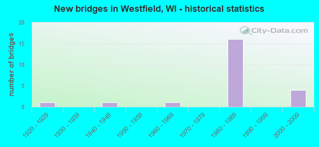
- New bridges - historical statistics
- 11920-1929
- 11940-1949
- 11960-1969
- 161980-1989
- 42000-2009

- Reconstructed bridges - Historical Statistics
- 11990-1999
- 02000-2009
- 22010-2019


- Bridge Condition - Deck
- 7.7%Very good
- 84.6%Good
- 7.7%Fair

- Bridge Condition - Superstructure
- 7.7%Excellent
- 15.4%Very good
- 61.5%Good
- 7.7%Satisfactory
- 7.7%Fair

- Bridge Condition - Substructure
- 38.5%Very good
- 46.2%Good
- 7.7%Satisfactory
- 7.7%Poor

- Bridge Condition - Channel
- 37.5%Very good
- 25.0%Good
- 12.5%Fair
- 25.0%Poor
Find on map >> Show street view
Structure Number: B390028, Location: 1.9M E JCT CTH J (Lat: 43.850217, Lng: -89.482961), Route carried "on" structure: County highway , Year Built: 1987, Year Reconstructed: 2016, Status: Open, Structure Length: 7.78m (25.52ft), Average Daily Traffic: 1,900 (year 2019), Average Future Daily Traffic: 1,900 (year 2037), Design Load: HS 20, Features Intersected: IH USH 51-IH 39, Facility Carried by Structure: CTH M
Minimum Vertical Clearance: 30+ m (98+ ft), Kilometerpoint: 0.000, Lanes on structure: 2, Lanes under structure: 4, Owner: State Highway Agency, Approaching Roadway Width: 10.4m (34.1ft), Material/Design: Steel continuous, Design/Construction: Stringer/Multi-beam, Number Of Spans In Main Unit: 2, Length of Maximum Span: 38.1m (125.0ft), Curb-To-Curb Width: 10.4m (34.1ft), Out-to-Out Width: 11.3m (37.1ft)
Condition: Deck: Good, Superstructure: Very good, Substructure: Good, Operating Rating: 67.0 metric tons, Method Used To Determine Operating Rating: Load Factor (LF), Inventory Rating: 40.5 metric tons, Method Used To Determine Inventory Rating: Load Factor (LF), Structural Evaluation: Better than present minimum criteria, Deck Geometry: Equal to present minimum criteria, Underclear: High priority of replacement, Approach Roadway Alignment: Equal to present desirable criteria, Length Of Structure Improvement: 8.23m (27.00ft), Designated Inspection Frequency: Every 48 months, Inspection Date: May 2018, Bridge Improvement Cost: $875,000, Roadway Improvement Cost: $87,000, Total Project Cost: $1,313,000 ( Estimate for 2021), Deck Structure Type: Concrete Cast-file-Place, Wearing Surface/Protective System: Wearing Surface: Monolithic Concrete, Deck Protection: Epoxy Coated Reinforcing
Find on map >> Show street view
Structure Number: B390029, Location: 0.9M S JCT CTH J (Lat: 43.871986, Lng: -89.483039), Route carried "on" structure: City street , Year Built: 1987, Year Reconstructed: 2016, Status: Open, Structure Length: 7.48m (24.54ft), Average Daily Traffic: 150 (year 2019), Average Future Daily Traffic: 150 (year 2037), Design Load: HS 20, Features Intersected: IH USH 51-IH 39, Facility Carried by Structure: LRD EDGEWOOD COURT
Minimum Vertical Clearance: 30+ m (98+ ft), Kilometerpoint: 0.000, Lanes on structure: 2, Lanes under structure: 4, Owner: State Highway Agency, Approaching Roadway Width: 9.8m (32.2ft), Material/Design: Steel continuous, Design/Construction: Stringer/Multi-beam, Number Of Spans In Main Unit: 2, Length of Maximum Span: 36.6m (120.1ft), Curb-To-Curb Width: 7.9m (25.9ft), Out-to-Out Width: 8.8m (28.9ft)
Condition: Deck: Good, Superstructure: Very good, Substructure: Very good, Operating Rating: 55.5 metric tons, Method Used To Determine Operating Rating: Load Factor (LF), Inventory Rating: 32.4 metric tons, Method Used To Determine Inventory Rating: Load Factor (LF), Structural Evaluation: Equal to present desirable criteria, Deck Geometry: Somewhat better than minimum adequacy, Underclear: Somewhat better than minimum adequacy, Approach Roadway Alignment: Equal to present desirable criteria, Designated Inspection Frequency: Every 48 months, Inspection Date: May 2018, Deck Structure Type: Concrete Cast-file-Place, Wearing Surface/Protective System: Wearing Surface: Monolithic Concrete, Deck Protection: Epoxy Coated Reinforcing
Find on map >> Show street view
Structure Number: B39003, Location: 6.5M N JCT STH 82 (Lat: 43.885278, Lng: -89.482850), Route carried "on" structure: Interstate 39, Year Built: 1987, Status: Open, Structure Length: 4.99m (16.37ft), Average Daily Traffic: 14,900 (year 2019), Truck Traffic: 20%, Average Future Daily Traffic: 14,300 (year 2039), Design Load: HS 20, Features Intersected: CTH EAST SECOND ST/CTH J
Minimum Vertical Clearance: 30+ m (98+ ft), Kilometerpoint: 0.000, Lanes on structure: 2, Lanes under structure: 2, Base Highway Network: Yes, Owner: State Highway Agency, Approaching Roadway Width: 12.2m (40.0ft), Material/Design: Prestressed concrete continuous, Design/Construction: Stringer/Multi-beam, Number Of Spans In Main Unit: 2, Length of Maximum Span: 24.7m (81.0ft), Curb-To-Curb Width: 12.3m (40.4ft), Out-to-Out Width: 13.3m (43.6ft)
Condition: Deck: Good, Superstructure: Good, Substructure: Good, Operating Rating: 52.3 metric tons, Method Used To Determine Operating Rating: Load Factor (LF), Inventory Rating: 30.8 metric tons, Method Used To Determine Inventory Rating: Load Factor (LF), Structural Evaluation: Better than present minimum criteria, Deck Geometry: Better than present minimum criteria, Underclear: Superior to present desirable criteria, Approach Roadway Alignment: Equal to present desirable criteria, Designated Inspection Frequency: Every 24 months, Inspection Date: April 2020, Deck Structure Type: Concrete Cast-file-Place, Wearing Surface/Protective System: Wearing Surface: Epoxy Overlay, Deck Protection: Epoxy Coated Reinforcing
Find on map >> Show street view
Structure Number: B390031, Location: 5.0M S JCT CTH Z (Lat: 43.885761, Lng: -89.483331), Route carried "on" structure: Interstate 39, Year Built: 1987, Status: Open, Structure Length: 4.99m (16.37ft), Average Daily Traffic: 14,900 (year 2019), Truck Traffic: 20%, Average Future Daily Traffic: 14,300 (year 2039), Design Load: HS 20, Features Intersected: CTH EAST SECOND ST(CTH J
Minimum Vertical Clearance: 30+ m (98+ ft), Kilometerpoint: 0.000, Lanes on structure: 2, Lanes under structure: 2, Base Highway Network: Yes, Owner: State Highway Agency, Approaching Roadway Width: 12.2m (40.0ft), Material/Design: Prestressed concrete continuous, Design/Construction: Stringer/Multi-beam, Number Of Spans In Main Unit: 2, Length of Maximum Span: 24.7m (81.0ft), Curb-To-Curb Width: 12.3m (40.4ft), Out-to-Out Width: 13.3m (43.6ft)
Condition: Deck: Good, Superstructure: Good, Substructure: Good, Operating Rating: 52.3 metric tons, Method Used To Determine Operating Rating: Load Factor (LF), Inventory Rating: 30.8 metric tons, Method Used To Determine Inventory Rating: Load Factor (LF), Structural Evaluation: Better than present minimum criteria, Deck Geometry: Better than present minimum criteria, Underclear: Superior to present desirable criteria, Approach Roadway Alignment: Equal to present desirable criteria, Designated Inspection Frequency: Every 24 months, Inspection Date: April 2020, Deck Structure Type: Concrete Cast-file-Place, Wearing Surface/Protective System: Wearing Surface: Epoxy Overlay, Deck Protection: Epoxy Coated Reinforcing
Find on map >> Show street view
Structure Number: B390032, Location: 3.5M N JCT CTH J (Lat: 43.933769, Lng: -89.481867), Route carried "on" structure: Interstate 39, Year Built: 1987, Status: Open, Structure Length: 3.56m (11.68ft), Average Daily Traffic: 13,000 (year 2019), Truck Traffic: 18%, Average Future Daily Traffic: 13,300 (year 2039), Design Load: HS 20, Features Intersected: LRD DOVER COURT
Minimum Vertical Clearance: 30+ m (98+ ft), Kilometerpoint: 0.000, Lanes on structure: 2, Lanes under structure: 2, Base Highway Network: Yes, Owner: State Highway Agency, Approaching Roadway Width: 12.2m (40.0ft), Material/Design: Concrete continuous, Design/Construction: Slab, Number Of Spans In Main Unit: 3, Length of Maximum Span: 16.2m (53.1ft), Curb-To-Curb Width: 12.2m (40.0ft), Out-to-Out Width: 13.1m (43.0ft)
Condition: Deck: Good, Superstructure: Good, Substructure: Good, Operating Rating: 60.4 metric tons, Method Used To Determine Operating Rating: Load Factor (LF), Inventory Rating: 35.6 metric tons, Method Used To Determine Inventory Rating: Load Factor (LF), Structural Evaluation: Better than present minimum criteria, Deck Geometry: Better than present minimum criteria, Underclear: Equal to present minimum criteria, Approach Roadway Alignment: Equal to present desirable criteria, Designated Inspection Frequency: Every 48 months, Inspection Date: April 2020, Deck Structure Type: Concrete Cast-file-Place, Wearing Surface/Protective System: Wearing Surface: Epoxy Overlay, Deck Protection: Epoxy Coated Reinforcing
Find on map >> Show street view
Structure Number: B390033, Location: 1.6M S JCT CTH Z (Lat: 43.934103, Lng: -89.483981), Route carried "on" structure: Interstate 39, Year Built: 1987, Status: Open, Structure Length: 3.65m (11.98ft), Average Daily Traffic: 9,000 (year 2019), Truck Traffic: 18%, Average Future Daily Traffic: 13,300 (year 2039), Design Load: HS 20, Features Intersected: LRD DOVER COURT
Minimum Vertical Clearance: 30+ m (98+ ft), Kilometerpoint: 0.000, Lanes on structure: 2, Lanes under structure: 2, Base Highway Network: Yes, Owner: State Highway Agency, Approaching Roadway Width: 12.2m (40.0ft), Material/Design: Concrete continuous, Design/Construction: Slab, Number Of Spans In Main Unit: 3, Length of Maximum Span: 16.2m (53.1ft), Curb-To-Curb Width: 12.2m (40.0ft), Out-to-Out Width: 13.1m (43.0ft)
Condition: Deck: Good, Superstructure: Good, Substructure: Good, Operating Rating: 68.6 metric tons, Method Used To Determine Operating Rating: Load Factor (LF), Inventory Rating: 40.5 metric tons, Method Used To Determine Inventory Rating: Load Factor (LF), Structural Evaluation: Better than present minimum criteria, Deck Geometry: Better than present minimum criteria, Underclear: Equal to present minimum criteria, Approach Roadway Alignment: Equal to present desirable criteria, Designated Inspection Frequency: Every 48 months, Inspection Date: April 2020, Deck Structure Type: Concrete Cast-file-Place, Wearing Surface/Protective System: Wearing Surface: Epoxy Overlay, Deck Protection: Epoxy Coated Reinforcing
Find on map >> Show street view
Structure Number: B390034, Location: 5.1M N JCT CTH J (Lat: 43.957906, Lng: -89.485031), Route carried "on" structure: Interstate 39, Year Built: 1987, Status: Open, Structure Length: 3.53m (11.58ft), Average Daily Traffic: 13,000 (year 2019), Truck Traffic: 18%, Average Future Daily Traffic: 13,300 (year 2039), Design Load: HS 20, Features Intersected: CTH Z
Minimum Vertical Clearance: 30+ m (98+ ft), Kilometerpoint: 0.000, Lanes on structure: 2, Lanes under structure: 2, Base Highway Network: Yes, Owner: State Highway Agency, Approaching Roadway Width: 12.2m (40.0ft), Skew: 1 degrees, Material/Design: Concrete continuous, Design/Construction: Slab, Number Of Spans In Main Unit: 3, Length of Maximum Span: 16.5m (54.1ft), Curb-To-Curb Width: 12.2m (40.0ft), Out-to-Out Width: 13.1m (43.0ft)
Condition: Deck: Good, Superstructure: Good, Substructure: Good, Operating Rating: 55.5 metric tons, Method Used To Determine Operating Rating: Load Factor (LF), Inventory Rating: 32.4 metric tons, Method Used To Determine Inventory Rating: Load Factor (LF), Structural Evaluation: Better than present minimum criteria, Deck Geometry: Better than present minimum criteria, Underclear: Equal to present minimum criteria, Approach Roadway Alignment: Equal to present desirable criteria, Designated Inspection Frequency: Every 48 months, Inspection Date: April 2020, Deck Structure Type: Concrete Cast-file-Place, Wearing Surface/Protective System: Wearing Surface: Epoxy Overlay, Deck Protection: Epoxy Coated Reinforcing
Find on map >> Show street view
Structure Number: B390058, Location: 0.2M S JCT CTH A (Lat: 43.880981, Lng: -89.543425), Route carried "on" structure: City street , Year Built: 2001, Status: Open, Structure Length: 1.58m (5.18ft), Average Daily Traffic: 160 (year 2018), Average Future Daily Traffic: 104 (year 2039), Design Load: HS 20, Features Intersected: WESTFIELD CREEK, Facility Carried by Structure: LRD 4TH AVE
Minimum Vertical Clearance: 30+ m (98+ ft), Kilometerpoint: 0.000, Lanes on structure: 2, Owner: Town or Township Highway Agency, Approaching Roadway Width: 9.1m (29.9ft), Material/Design: Prestressed concrete, Design/Construction: Stringer/Multi-beam, Number Of Spans In Main Unit: 1, Length of Maximum Span: 15.0m (49.2ft), Curb-To-Curb Width: 7.3m (24.0ft), Out-to-Out Width: 7.9m (25.9ft)
Condition: Deck: Good, Superstructure: Good, Substructure: Very good, Channel: Very good, Operating Rating: 53.9 metric tons, Method Used To Determine Operating Rating: Load Factor (LF), Inventory Rating: 43.7 metric tons, Method Used To Determine Inventory Rating: Load Factor (LF), Structural Evaluation: Better than present minimum criteria, Deck Geometry: Somewhat better than minimum adequacy, Waterway Adequacy: Equal to present desirable criteria, Approach Roadway Alignment: Equal to present minimum criteria, Designated Inspection Frequency: Every 48 months, Inspection Date: August 2020, Deck Structure Type: Concrete Cast-file-Place, Wearing Surface/Protective System: Wearing Surface: Monolithic Concrete, Deck Protection: Epoxy Coated Reinforcing
Find on map >> Show street view
Structure Number: B390063, Location: 1.4 M N JCT CTH M (Lat: 43.921278, Lng: -89.492778), Route carried "on" structure: County highway , Year Built: 2002, Status: Open, Structure Length: 0.99m (3.25ft), Average Daily Traffic: 1,180 (year 2018), Average Future Daily Traffic: 1,205 (year 2039), Design Load: HS 20, Features Intersected: CAVES CR, Facility Carried by Structure: CTH CH
Minimum Vertical Clearance: 30+ m (98+ ft), Kilometerpoint: 0.000, Lanes on structure: 2, Owner: County Highway Agency, Approaching Roadway Width: 9.8m (32.2ft), Material/Design: Concrete, Design/Construction: Slab, Number Of Spans In Main Unit: 1, Length of Maximum Span: 9.1m (29.9ft), Curb-To-Curb Width: 9.1m (29.9ft), Out-to-Out Width: 9.8m (32.2ft)
Condition: Deck: Good, Superstructure: Good, Substructure: Very good, Channel: Good, Operating Rating: 68.6 metric tons, Method Used To Determine Operating Rating: Load Factor (LF), Inventory Rating: 40.5 metric tons, Method Used To Determine Inventory Rating: Load Factor (LF), Structural Evaluation: Better than present minimum criteria, Deck Geometry: Somewhat better than minimum adequacy, Waterway Adequacy: Equal to present desirable criteria, Approach Roadway Alignment: Equal to present desirable criteria, Designated Inspection Frequency: Every 48 months, Inspection Date: August 2020, Deck Structure Type: Concrete Cast-file-Place, Wearing Surface/Protective System: Wearing Surface: Monolithic Concrete, Deck Protection: Epoxy Coated Reinforcing
Find on map >> Show street view
Structure Number: B390064, Location: 0.3M N OF DOVER (Lat: 43.956083, Lng: -89.493556), Route carried "on" structure: County highway , Year Built: 2004, Status: Open, Structure Length: 0.87m (2.85ft), Average Daily Traffic: 1,070 (year 2018), Average Future Daily Traffic: 116 (year 2039), Design Load: HS 20, Features Intersected: TAGATZ CREEK, Facility Carried by Structure: CTH CH
Minimum Vertical Clearance: 30+ m (98+ ft), Kilometerpoint: 0.000, Lanes on structure: 2, Owner: County Highway Agency, Approaching Roadway Width: 9.1m (29.9ft), Skew: 1 degrees, Material/Design: Concrete, Design/Construction: Slab, Number Of Spans In Main Unit: 1, Length of Maximum Span: 8.7m (28.5ft), Curb-To-Curb Width: 9.1m (29.9ft), Out-to-Out Width: 9.8m (32.2ft)
Condition: Deck: Good, Superstructure: Good, Substructure: Very good, Channel: Good, Operating Rating: 70.2 metric tons, Method Used To Determine Operating Rating: Load Factor (LF), Inventory Rating: 42.1 metric tons, Method Used To Determine Inventory Rating: Load Factor (LF), Structural Evaluation: Better than present minimum criteria, Deck Geometry: Somewhat better than minimum adequacy, Waterway Adequacy: Equal to present desirable criteria, Approach Roadway Alignment: Equal to present desirable criteria, Designated Inspection Frequency: Every 48 months, Inspection Date: August 2020, Wearing Surface/Protective System: Wearing Surface: Monolithic Concrete, Deck Protection: Epoxy Coated Reinforcing
Find on map >> Show street view
Structure Number: B390068, Location: 0.7M W JCT USH 51 (Lat: 43.883283, Lng: -89.495158), Route carried "on" structure: City street , Year Built: 2004, Status: Open, Structure Length: 1.87m (6.14ft), Average Daily Traffic: 1,970 (year 2018), Truck Traffic: 7%, Average Future Daily Traffic: 1,982 (year 2039), Design Load: HS 20, Features Intersected: WESTFIELD CREEK, Facility Carried by Structure: LRD W 4TH ST/CTH E
Minimum Vertical Clearance: 30+ m (98+ ft), Kilometerpoint: 0.000, Lanes on structure: 2, Owner: City or Municipal Highway Agency, Maintenance Responsibility: County Highway Agency, Approaching Roadway Width: 11.3m (37.1ft), Material/Design: Prestressed concrete, Design/Construction: Stringer/Multi-beam, Number Of Spans In Main Unit: 1, Length of Maximum Span: 18.0m (59.1ft), Curb or Sidewalk Widths: Left: 2.0m (6.6ft), Right: 0.0m, Curb-To-Curb Width: 11.0m (36.1ft), Out-to-Out Width: 13.8m (45.3ft)
Condition: Deck: Very good, Superstructure: Excellent, Substructure: Very good, Channel: Very good, Operating Rating: 70.2 metric tons, Method Used To Determine Operating Rating: Load Factor (LF), Inventory Rating: 35.6 metric tons, Method Used To Determine Inventory Rating: Load Factor (LF), Structural Evaluation: Equal to present desirable criteria, Deck Geometry: Equal to present minimum criteria, Waterway Adequacy: Equal to present desirable criteria, Approach Roadway Alignment: Equal to present desirable criteria, Designated Inspection Frequency: Every 48 months, Inspection Date: August 2020, Deck Structure Type: Concrete Cast-file-Place, Wearing Surface/Protective System: Wearing Surface: Monolithic Concrete, Deck Protection: Epoxy Coated Reinforcing
Find on map >> Show street view
Structure Number: B39097, Location: 0.2M E JCT CTH Y (Lat: 43.791972, Lng: -89.327911), Route carried "on" structure: State highway 23, Year Built: 1948, Year Reconstructed: 1997, Status: Open, Structure Length: 1.11m (3.64ft), Average Daily Traffic: 7,900 (year 2019), Truck Traffic: 8%, Average Future Daily Traffic: 11,830 (year 2040), Design Load: H 20, Features Intersected: MONTELLO RIVER
Minimum Vertical Clearance: 30+ m (98+ ft), Kilometerpoint: 0.000, Lanes on structure: 2, Base Highway Network: Yes, Owner: State Highway Agency, Approaching Roadway Width: 14.6m (47.9ft), Material/Design: Steel, Design/Construction: Stringer/Multi-beam, Number Of Spans In Main Unit: 1, Length of Maximum Span: 11.1m (36.4ft), Curb or Sidewalk Widths: Left: 2.7m (8.9ft), Right: 3.4m (11.2ft), Curb-To-Curb Width: 11.1m (36.4ft), Out-to-Out Width: 18.0m (59.1ft)
Condition: Deck: Good, Superstructure: Satisfactory, Substructure: Satisfactory, Channel: Very good, Operating Rating: 52.3 metric tons, Method Used To Determine Operating Rating: Load Factor (LF), Inventory Rating: 30.8 metric tons, Method Used To Determine Inventory Rating: Load Factor (LF), Structural Evaluation: Equal to present minimum criteria, Deck Geometry: Meets minimum limits, Waterway Adequacy: Superior to present desirable criteria, Approach Roadway Alignment: Equal to present desirable criteria, Designated Inspection Frequency: Every 24 months, Inspection Date: June 2021, Deck Structure Type: Concrete Cast-file-Place, Wearing Surface/Protective System: Wearing Surface: Epoxy Overlay
Find on map >> Show street view
Structure Number: B390977, Location: 0.7M W JCT USH 51 (Lat: 43.888083, Lng: -89.494164), Route carried "on" structure: City street , Year Built: 1929, Status: Open, Structure Length: 0.77m (2.53ft), Average Daily Traffic: 2,825 (year 2019), Average Future Daily Traffic: 2,972 (year 2040), Design Load: H 15, Features Intersected: BR WESTFIELD CREEK, Facility Carried by Structure: LRD MAIN ST
Minimum Vertical Clearance: 30+ m (98+ ft), Kilometerpoint: 0.000, Lanes on structure: 2, Owner: City or Municipal Highway Agency, Approaching Roadway Width: 8.2m (26.9ft), Skew: 2 degrees, Material/Design: Concrete, Design/Construction: Slab, Number Of Spans In Main Unit: 1, Length of Maximum Span: 6.7m (22.0ft), Curb or Sidewalk Widths: Left: 2.0m (6.6ft), Right: 2.0m (6.6ft), Curb-To-Curb Width: 8.2m (26.9ft), Out-to-Out Width: 8.8m (28.9ft)
Condition: Deck: Fair, Superstructure: Fair, Substructure: Poor, Channel: Poor, Operating Rating: 45.7 metric tons, Method Used To Determine Operating Rating: Load Factor (LF), Inventory Rating: 27.5 metric tons, Method Used To Determine Inventory Rating: Load Factor (LF), Structural Evaluation: Meets minimum limits, Deck Geometry: High priority of corrective action, Waterway Adequacy: Equal to present minimum criteria, Approach Roadway Alignment: Equal to present desirable criteria, Length Of Structure Improvement: 1.22m (4.00ft), Designated Inspection Frequency: Every 12 months, Inspection Date: August 2021, Bridge Improvement Cost: $130,000, Roadway Improvement Cost: $13,000, Total Project Cost: $195,000 ( Estimate for 2021), Deck Structure Type: Concrete Cast-file-Place, Wearing Surface/Protective System: Wearing Surface: Bituminous
Find on map >> Show street view
Structure Number: P390903, Location: 1.0M N JCT CTH E TO E (Lat: 43.900817, Lng: -89.426283), Route carried "on" structure: County highway , Year Built: 1966, Status: Open, Structure Length: 0.75m (2.46ft), Average Daily Traffic: 530 (year 2018), Average Future Daily Traffic: 346 (year 2039), Design Load: H 15, Features Intersected: WESTFIELD CREEK, Facility Carried by Structure: CTH B
Minimum Vertical Clearance: 30+ m (98+ ft), Kilometerpoint: 0.000, Lanes on structure: 2, Owner: County Highway Agency, Approaching Roadway Width: 9.1m (29.9ft), Skew: 1 degrees, Material/Design: Steel, Design/Construction: Culvert, Number Of Spans In Main Unit: 2, Length of Maximum Span: 3.4m (11.2ft)
Condition: Channel: Poor, Culverts: Satisfactory, Operating Rating: 53.9 metric tons, Method Used To Determine Operating Rating: Field evaluation and documented engineering judgment, Inventory Rating: 24.3 metric tons, Method Used To Determine Inventory Rating: Field evaluation and documented engineering judgment, Structural Evaluation: Equal to present minimum criteria, Waterway Adequacy: Equal to present minimum criteria, Approach Roadway Alignment: Equal to present desirable criteria, Designated Inspection Frequency: Every 24 months, Inspection Date: August 2020, Deck Structure Type: Concrete Cast-file-Place, Wearing Surface/Protective System: Wearing Surface: Bituminous
Find on map >> Show street view
Structure Number: P390907, Location: 0.6M N JCT CTH E (Lat: 43.909772, Lng: -89.427419), Route carried "on" structure: County highway , Year Built: 1981, Status: Open, Structure Length: 0.72m (2.36ft), Average Daily Traffic: 210 (year 2018), Average Future Daily Traffic: 155 (year 2039), Design Load: H 15, Features Intersected: MONTELLO RIVER, Facility Carried by Structure: CTH B
Minimum Vertical Clearance: 30+ m (98+ ft), Kilometerpoint: 0.000, Lanes on structure: 2, Owner: County Highway Agency, Approaching Roadway Width: 9.1m (29.9ft), Material/Design: Steel, Design/Construction: Culvert, Number Of Spans In Main Unit: 2, Length of Maximum Span: 3.2m (10.5ft)
Condition: Channel: Fair, Culverts: Satisfactory, Operating Rating: 53.9 metric tons, Method Used To Determine Operating Rating: Field evaluation and documented engineering judgment, Inventory Rating: 24.3 metric tons, Method Used To Determine Inventory Rating: Field evaluation and documented engineering judgment, Structural Evaluation: Equal to present minimum criteria, Waterway Adequacy: Equal to present desirable criteria, Approach Roadway Alignment: Equal to present desirable criteria, Designated Inspection Frequency: Every 24 months, Inspection Date: August 2020, Deck Structure Type: Steel plate, Wearing Surface/Protective System: Wearing Surface: Bituminous
Find on map >> Show street view
Structure Number: B390028, Location: 4.2M N JCT STH 23 TO E (Lat: 43.850217, Lng: -89.482961), Route carried "under" structure: Interstate 39, Year Built: 1987, Structure Length: 0. m, Average Daily Traffic: 10,800 (year 2019), Truck Traffic: 20%, Features Intersected: IH USH 51-IH 39, Facility Carried by Structure: CTH M
Minimum Vertical Clearance: 5.18m (16.99ft), Kilometerpoint: 0.000, Lanes on structure: 2, Lanes under structure: 4, Material/Design: Steel continuous, Design/Construction: Stringer/Multi-beam, Length of Maximum Span: 38.1m (125.0ft)
Find on map >> Show street view
Structure Number: B390029, Location: 1.5M N JCT CTH M (Lat: 43.871986, Lng: -89.483039), Route carried "under" structure: Interstate 39, Year Built: 1987, Structure Length: 0. m, Average Daily Traffic: 10,800 (year 2019), Truck Traffic: 20%, Features Intersected: IH USH 51-IH 39, Facility Carried by Structure: LRD EDGEWOOD COURT
Minimum Vertical Clearance: 5.00m (16.40ft), Kilometerpoint: 0.000, Lanes on structure: 2, Lanes under structure: 4, Material/Design: Steel continuous, Design/Construction: Stringer/Multi-beam, Length of Maximum Span: 36.6m (120.1ft)
Find on map >> Show street view
Structure Number: B39003, Location: VILLAGE OF WESTFIELD (Lat: 43.885278, Lng: -89.482850), Route carried "under" structure: County highway , Year Built: 1987, Structure Length: 0. m, Average Daily Traffic: 6,400 (year 2018), Features Intersected: CTH EAST SECOND ST/CTH J, Facility Carried by Structure: IH USH51-IH39 NB
Minimum Vertical Clearance: 5.06m (16.60ft), Kilometerpoint: 0.000, Lanes on structure: 2, Lanes under structure: 2, Material/Design: Prestressed concrete continuous, Design/Construction: Stringer/Multi-beam, Length of Maximum Span: 24.7m (81.0ft)
Find on map >> Show street view
Structure Number: B390031, Location: VILLAGE OF WESTFIELD (Lat: 43.885761, Lng: -89.483331), Route carried "under" structure: County highway , Year Built: 1987, Structure Length: 0. m, Average Daily Traffic: 6,400 (year 2018), Features Intersected: CTH EAST SECOND ST(CTH J, Facility Carried by Structure: IH USH51-IH39 SB
Minimum Vertical Clearance: 5.06m (16.60ft), Kilometerpoint: 0.000, Lanes on structure: 2, Lanes under structure: 2, Material/Design: Prestressed concrete continuous, Design/Construction: Stringer/Multi-beam, Length of Maximum Span: 24.7m (81.0ft)
Find on map >> Show street view
Structure Number: B390032, Location: 0.7M W JCT CTH H (Lat: 43.933769, Lng: -89.481867), Route carried "under" structure: City street , Year Built: 1987, Structure Length: 0. m, Average Daily Traffic: 350 (year 2019), Features Intersected: LRD DOVER COURT, Facility Carried by Structure: IH USH51-IH39 NB
Minimum Vertical Clearance: 4.57m (14.99ft), Kilometerpoint: 0.000, Lanes on structure: 2, Lanes under structure: 2, Material/Design: Concrete continuous, Design/Construction: Slab, Length of Maximum Span: 16.2m (53.1ft)
Find on map >> Show street view
Structure Number: B390033, Location: 0.6M W JCT CTH H (Lat: 43.934103, Lng: -89.483981), Route carried "under" structure: City street , Year Built: 1987, Structure Length: 0. m, Average Daily Traffic: 350 (year 2019), Features Intersected: LRD DOVER COURT, Facility Carried by Structure: IH USH51-IH 39 SB
Minimum Vertical Clearance: 4.42m (14.50ft), Kilometerpoint: 0.000, Lanes on structure: 2, Lanes under structure: 2, Material/Design: Concrete continuous, Design/Construction: Slab, Length of Maximum Span: 16.2m (53.1ft)
Find on map >> Show street view
Structure Number: B390034, Location: 0.4M W JCT CTH H (Lat: 43.957906, Lng: -89.485031), Route carried "under" structure: County highway , Year Built: 1987, Structure Length: 0. m, Average Daily Traffic: 350 (year 2019), Features Intersected: CTH Z, Facility Carried by Structure: IH USH51-IH39 NB
Minimum Vertical Clearance: 4.65m (15.26ft), Kilometerpoint: 0.000, Lanes on structure: 2, Lanes under structure: 2, Material/Design: Concrete continuous, Design/Construction: Slab, Length of Maximum Span: 16.5m (54.1ft)
Find on map >> Show street view
Structure Number: B39004, Location: 0.4M W JCT CTH H (Lat: 43.958069, Lng: -89.485683), Route carried "under" structure: County highway , Year Built: 1987, Structure Length: 0. m, Average Daily Traffic: 350 (year 2019), Features Intersected: CTH Z, Facility Carried by Structure: IH USH51-IH39 SB
Minimum Vertical Clearance: 4.62m (15.16ft), Kilometerpoint: 0.000, Lanes on structure: 2, Lanes under structure: 2, Material/Design: Concrete continuous, Design/Construction: Slab, Length of Maximum Span: 16.5m (54.1ft)