Bridge Statistics for West Springfield, Massachusetts (MA)
Condition, Traffic, Stress, Structural Evaluation, Project Costs
- National Bridge Inventory (NBI) Statistics
- 36Number of bridges
- 282ft / 86.0mTotal length
- $93,546,000Total costs
- 923,430Total average daily traffic
- 69,749Total average daily truck traffic
- National Bridge Inventory (NBI) Registered Bridges for West Springfield
- No street view available for this location
- New bridges - historical statistics
- 11920-1929
- 161950-1959
- 171960-1969
- 12010-2019
- 12020-2022
- Reconstructed bridges - Historical Statistics
- 11970-1979
- 61980-1989
- 11990-1999
- 02000-2009
- 22010-2019
- Bridge Condition - Deck
- 12.0%Very good
- 36.0%Good
- 24.0%Satisfactory
- 24.0%Fair
- 4.0%Serious
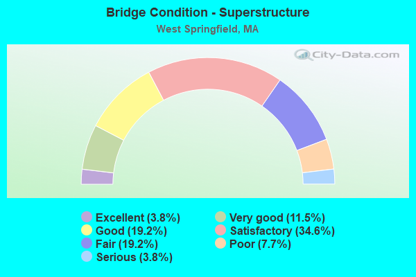
- Bridge Condition - Superstructure
- 3.8%Excellent
- 11.5%Very good
- 19.2%Good
- 34.6%Satisfactory
- 19.2%Fair
- 7.7%Poor
- 3.8%Serious
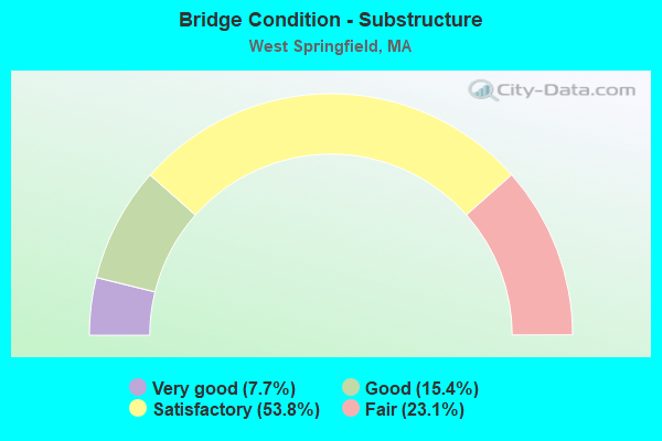
- Bridge Condition - Substructure
- 7.7%Very good
- 15.4%Good
- 53.8%Satisfactory
- 23.1%Fair
Find on map >> Show street view
Structure Number: A05002BQVDOTNBI, Location: RTE 147 AT WESTFIELD RIV (Lat: 42.089942, Lng: -72.626786), Route carried "on" structure: State highway 147, Year Built: 2021, Status: Open, Structure Length: 10.41m (34.15ft), Average Daily Traffic: 22,500 (year 2017), Truck Traffic: 10%, Design Load: HL 93, Features Intersected: WATER WESTFIELD RIVER
Minimum Vertical Clearance: 30+ m (98+ ft), Kilometerpoint: 4.055, Lanes on structure: 5, Owner: State Highway Agency, Approaching Roadway Width: 18.9m (62.0ft), Material/Design: Steel continuous, Design/Construction: Stringer/Multi-beam, Number Of Spans In Main Unit: 3, Length of Maximum Span: 38.0m (124.7ft), Curb or Sidewalk Widths: Left: 1.8m (5.9ft), Right: 5.5m (18.0ft), Curb-To-Curb Width: 18.9m (62.0ft), Out-to-Out Width: 26.3m (86.3ft)
Condition: Deck: Very good, Superstructure: Excellent, Substructure: Very good, Channel: Good, Operating Rating: 42.1 metric tons, Method Used To Determine Operating Rating: Assigned ratings based on Load and Resistance Factor Design (LRFD) reported by rating factor (RF) using HL93 loadings, Inventory Rating: 32.4 metric tons, Method Used To Determine Inventory Rating: Assigned ratings based on Load and Resistance Factor Design (LRFD) reported by rating factor (RF) using HL93 loadings, Structural Evaluation: Equal to present desirable criteria, Deck Geometry: Meets minimum limits, Waterway Adequacy: Equal to present desirable criteria, Approach Roadway Alignment: Equal to present minimum criteria, Designated Inspection Frequency: Every 24 months, Inspection Date: July 2021, Deck Structure Type: Concrete Cast-file-Place, Wearing Surface/Protective System: Wearing Surface: Bituminous, Membrane: Epoxy, Deck Protection: Epoxy Coated Reinforcing
Find on map >> Show street view
Structure Number: W21008BPQDOTNBI, Location: JCT CHARLES AVE. (Lat: 42.104306, Lng: -72.679242), Route carried "on" structure: US 20, Year Built: 2014, Status: Open, Structure Length: 3.57m (11.71ft), Average Daily Traffic: 30,775 (year 2016), Truck Traffic: 3%, Design Load: HL 93, Features Intersected: RR CSX
Minimum Vertical Clearance: 30+ m (98+ ft), Kilometerpoint: 93.463, Lanes on structure: 4, Base Highway Network: Yes, Owner: State Highway Agency, Approaching Roadway Width: 17.6m (57.7ft), Skew: 5 degrees, Material/Design: Steel, Design/Construction: Stringer/Multi-beam, Number Of Spans In Main Unit: 1, Length of Maximum Span: 33.5m (109.9ft), Curb or Sidewalk Widths: Left: 0.0m, Right: 1.7m (5.6ft), Curb-To-Curb Width: 17.1m (56.1ft), Out-to-Out Width: 19.6m (64.3ft)
Condition: Deck: Good, Superstructure: Very good, Substructure: Very good, Operating Rating: 64.8 metric tons, Method Used To Determine Operating Rating: Load and Resistance Factor Rating (LRFR) rating reported by rating factor(RF) method using HL-93 loadings, Inventory Rating: 48.6 metric tons, Method Used To Determine Inventory Rating: Load and Resistance Factor Rating (LRFR) rating reported by rating factor(RF) method using HL-93 loadings, Structural Evaluation: Equal to present desirable criteria, Deck Geometry: Somewhat better than minimum adequacy, Underclear: Meets minimum limits, Approach Roadway Alignment: Equal to present minimum criteria, Designated Inspection Frequency: Every 24 months, Inspection Date: December 2020, Deck Structure Type: Concrete Cast-file-Place, Wearing Surface/Protective System: Wearing Surface: Bituminous, Membrane: Preformed Fabric, Deck Protection: Epoxy Coated Reinforcing
Find on map >> Show street view
Structure Number: W2101114WDOT634, Location: .1 M E WESTFIELD T.L. (Lat: 42.143114, Lng: -72.684264), Route carried "on" structure: City street , Year Built: 1926, Status: Closed, Structure Length: 0.81m (2.66ft), Average Future Daily Traffic: 1,224 (year 2031), Design Load: H 20, Features Intersected: RR PVRR, Facility Carried by Structure: HWY PROSPECT AVE
Minimum Vertical Clearance: 30+ m (98+ ft), Kilometerpoint: 0.000, Lanes on structure: 2, Owner: State Highway Agency, Approaching Roadway Width: 6.4m (21.0ft), Material/Design: Wood or Timber, Design/Construction: Stringer/Multi-beam, Number Of Spans In Main Unit: 1, Length of Maximum Span: 6.8m (22.3ft), Curb-To-Curb Width: 6.1m (20.0ft), Out-to-Out Width: 6.5m (21.3ft)
Condition: Deck: Serious, Superstructure: Poor, Substructure: Fair, Operating Rating: 3.7 metric tons, Method Used To Determine Operating Rating: Load Factor (LF), Inventory Rating: 1.9 metric tons, Method Used To Determine Inventory Rating: Load Factor (LF), Deck Geometry: Somewhat better than minimum adequacy, Approach Roadway Alignment: Equal to present minimum criteria, Bridge Posting: Required (Relationship of Operating Rating to Maximum Legal Load: > 39.9% below), Length Of Structure Improvement: 1.50m (4.92ft), Designated Inspection Frequency: Every 24 months, Inspection Date: October 2021, Bridge Improvement Cost: $802,000, Roadway Improvement Cost: $81,000, Total Project Cost: $1,204,000 ( Estimate for 2022), Deck Structure Type: Wood or Timber, Wearing Surface/Protective System: Wearing Surface: Wood or Timber
Find on map >> Show street view
Structure Number: W210234K7DOTNBI, Location: MM 45.8 ON I-90 (Lat: 42.153639, Lng: -72.638539), Route carried "on" structure: Interstate 90, Year Built: 1957, Year Reconstructed: 1993, Status: Open, Structure Length: 1.82m (5.97ft), Average Daily Traffic: 23,994 (year 2017), Truck Traffic: 12%, Average Future Daily Traffic: 49,260 (year 2031), Design Load: HS 20+Mod, Features Intersected: I 90 EXIT 45 RAMPS
Minimum Vertical Clearance: 30+ m (98+ ft), Kilometerpoint: 73.545, Lanes on structure: 3, Lanes under structure: 2, Base Highway Network: Yes, Toll: On toll road, Owner: State Highway Agency, Approaching Roadway Width: 18.0m (59.1ft), Material/Design: Steel, Design/Construction: Stringer/Multi-beam, Number Of Spans In Main Unit: 1, Length of Maximum Span: 16.8m (55.1ft), Curb-To-Curb Width: 18.0m (59.1ft), Out-to-Out Width: 18.9m (62.0ft)
Condition: Deck: Satisfactory, Superstructure: Satisfactory, Substructure: Satisfactory, Operating Rating: 68.0 metric tons, Method Used To Determine Operating Rating: Load Factor (LF), Inventory Rating: 40.8 metric tons, Method Used To Determine Inventory Rating: Load Factor (LF), Structural Evaluation: Equal to present minimum criteria, Deck Geometry: Better than present minimum criteria, Underclear: High priority of corrective action, Approach Roadway Alignment: Equal to present desirable criteria, Length Of Structure Improvement: 1.90m (6.23ft), Designated Inspection Frequency: Every 24 months, Inspection Date: June 2020, Bridge Improvement Cost: $72,000, Roadway Improvement Cost: $8,000, Total Project Cost: $109,000 ( Estimate for 2022), Deck Structure Type: Concrete Cast-file-Place, Wearing Surface/Protective System: Wearing Surface: Bituminous, Membrane: Built-up
Find on map >> Show street view
Structure Number: W210234K8DOTNBI, Location: MM 45.8 ON I-90 (Lat: 42.153803, Lng: -72.638569), Route carried "on" structure: Interstate 90, Year Built: 1957, Year Reconstructed: 1993, Status: Open, Structure Length: 1.82m (5.97ft), Average Daily Traffic: 25,343 (year 2017), Truck Traffic: 12%, Average Future Daily Traffic: 49,260 (year 2031), Design Load: HS 20+Mod, Features Intersected: I 90 EXIT 45 RAMPS
Minimum Vertical Clearance: 30+ m (98+ ft), Kilometerpoint: 73.545, Lanes on structure: 2, Lanes under structure: 2, Base Highway Network: Yes, Toll: On toll road, Owner: State Highway Agency, Approaching Roadway Width: 12.6m (41.3ft), Material/Design: Steel, Design/Construction: Stringer/Multi-beam, Number Of Spans In Main Unit: 1, Length of Maximum Span: 16.8m (55.1ft), Curb-To-Curb Width: 12.6m (41.3ft), Out-to-Out Width: 13.6m (44.6ft)
Condition: Deck: Good, Superstructure: Satisfactory, Substructure: Satisfactory, Operating Rating: 66.4 metric tons, Method Used To Determine Operating Rating: Load Factor (LF), Inventory Rating: 39.5 metric tons, Method Used To Determine Inventory Rating: Load Factor (LF), Structural Evaluation: Equal to present minimum criteria, Deck Geometry: Better than present minimum criteria, Underclear: High priority of corrective action, Approach Roadway Alignment: Equal to present desirable criteria, Length Of Structure Improvement: 1.90m (6.23ft), Designated Inspection Frequency: Every 24 months, Inspection Date: June 2020, Bridge Improvement Cost: $36,000, Roadway Improvement Cost: $4,000, Total Project Cost: $55,000 ( Estimate for 2022), Deck Structure Type: Concrete Cast-file-Place, Wearing Surface/Protective System: Wearing Surface: Bituminous, Membrane: Built-up
Find on map >> Show street view
Structure Number: W210244K9DOTNBI, Location: MM 45.0 ON I-90 (Lat: 42.153303, Lng: -72.653689), Route carried "on" structure: Interstate 90, Year Built: 1957, Year Reconstructed: 1994, Status: Temporarily open, Structure Length: 5.58m (18.31ft), Average Daily Traffic: 10,474 (year 2019), Truck Traffic: 1%, Average Future Daily Traffic: 9,476 (year 2032), Design Load: H 20, Features Intersected: I 90, Facility Carried by Structure: HWY BIRNIE AVE
Minimum Vertical Clearance: 4.34m (14.24ft), Kilometerpoint: 72.418, Lanes on structure: 2, Lanes under structure: 4, Owner: State Highway Agency, Approaching Roadway Width: 9.1m (29.9ft), Skew: 1 degrees, Material/Design: Steel continuous, Design/Construction: Stringer/Multi-beam, Number Of Spans In Main Unit: 4, Length of Maximum Span: 16.3m (53.5ft), Curb or Sidewalk Widths: Left: 0.8m (2.6ft), Right: 1.5m (4.9ft), Curb-To-Curb Width: 7.3m (24.0ft), Out-to-Out Width: 12.3m (40.4ft)
Condition: Deck: Satisfactory, Superstructure: Serious, Substructure: Satisfactory, Operating Rating: 49.4 metric tons, Method Used To Determine Operating Rating: Load Factor (LF), Inventory Rating: 29.6 metric tons, Method Used To Determine Inventory Rating: Load Factor (LF), Structural Evaluation: High priority of corrective action, Deck Geometry: High priority of replacement, Underclear: High priority of replacement, Approach Roadway Alignment: Equal to present desirable criteria, Length Of Structure Improvement: 6.70m (21.98ft), Designated Inspection Frequency: Every 6 months, Other Special Inspection Frequency: Every 6 months, Inspection Date: April 2021, Other Special Inspection Date: October 2021, Bridge Improvement Cost: $6,458,000, Roadway Improvement Cost: $646,000, Total Project Cost: $9,688,000 ( Estimate for 2022), Deck Structure Type: Concrete Cast-file-Place, Wearing Surface/Protective System: Wearing Surface: Bituminous, Membrane: Preformed Fabric, Deck Protection: Epoxy Coated Reinforcing
Find on map >> Show street view
Structure Number: W2102515CDOTNBI, Location: AT JCT US 5 & MEMORIAL AV (Lat: 42.097217, Lng: -72.596589), Route carried "on" structure: State highway 147, Year Built: 1953, Year Reconstructed: 2015, Status: Open, Structure Length: 2.44m (8.01ft), Average Daily Traffic: 10,893 (year 2017), Truck Traffic: 13%, Average Future Daily Traffic: 20,689 (year 2033), Design Load: HL 93, Features Intersected: US 5 RIVERDALE ST
Minimum Vertical Clearance: 30+ m (98+ ft), Kilometerpoint: 6.357, Lanes on structure: 2, Lanes under structure: 4, Base Highway Network: Yes, Owner: State Highway Agency, Approaching Roadway Width: 13.3m (43.6ft), Skew: 9 degrees, Material/Design: Steel, Design/Construction: Stringer/Multi-beam, Number Of Spans In Main Unit: 1, Length of Maximum Span: 23.2m (76.1ft), Curb or Sidewalk Widths: Left: 0.3m (1.0ft), Right: 2.4m (7.9ft), Curb-To-Curb Width: 13.3m (43.6ft), Out-to-Out Width: 17.5m (57.4ft)
Condition: Deck: Very good, Superstructure: Very good, Substructure: Good, Operating Rating: 51.4 metric tons, Method Used To Determine Operating Rating: Load Factor (LF), Inventory Rating: 30.8 metric tons, Method Used To Determine Inventory Rating: Load Factor (LF), Structural Evaluation: Better than present minimum criteria, Deck Geometry: Superior to present desirable criteria, Underclear: High priority of corrective action, Approach Roadway Alignment: Equal to present desirable criteria, Designated Inspection Frequency: Every 24 months, Inspection Date: March 2020, Deck Structure Type: Concrete Precast Panels, Wearing Surface/Protective System: Wearing Surface: Bituminous, Membrane: Preformed Fabric, Deck Protection: Epoxy Coated Reinforcing
Find on map >> Show street view
Structure Number: W2102515DDOTNBI, Location: AT JCT US 5 & MEMORIAL AV (Lat: 42.097933, Lng: -72.597503), Route carried "on" structure: State highway 147, Year Built: 1953, Year Reconstructed: 2015, Status: Open, Structure Length: 2.43m (7.97ft), Average Daily Traffic: 10,273 (year 2017), Truck Traffic: 13%, Average Future Daily Traffic: 20,689 (year 2033), Design Load: HL 93, Features Intersected: US 5 RIVERDALE ST
Minimum Vertical Clearance: 30+ m (98+ ft), Kilometerpoint: 6.357, Lanes on structure: 2, Lanes under structure: 4, Base Highway Network: Yes, Owner: State Highway Agency, Approaching Roadway Width: 14.5m (47.6ft), Skew: 9 degrees, Material/Design: Steel, Design/Construction: Stringer/Multi-beam, Number Of Spans In Main Unit: 1, Length of Maximum Span: 23.2m (76.1ft), Curb or Sidewalk Widths: Left: 0.3m (1.0ft), Right: 2.4m (7.9ft), Curb-To-Curb Width: 14.5m (47.6ft), Out-to-Out Width: 19.8m (65.0ft)
Condition: Deck: Very good, Superstructure: Very good, Substructure: Good, Operating Rating: 42.1 metric tons, Method Used To Determine Operating Rating: Assigned ratings based on Load and Resistance Factor Design (LRFD) reported by rating factor (RF) using HL93 loadings, Inventory Rating: 32.4 metric tons, Method Used To Determine Inventory Rating: Assigned ratings based on Load and Resistance Factor Design (LRFD) reported by rating factor (RF) using HL93 loadings, Structural Evaluation: Better than present minimum criteria, Deck Geometry: Superior to present desirable criteria, Underclear: High priority of corrective action, Approach Roadway Alignment: Equal to present desirable criteria, Designated Inspection Frequency: Every 24 months, Inspection Date: March 2020, Deck Structure Type: Concrete Precast Panels, Wearing Surface/Protective System: Wearing Surface: Bituminous, Membrane: Preformed Fabric, Deck Protection: Epoxy Coated Reinforcing
Find on map >> Show street view
Structure Number: W210270U9DOTNBI, Location: AT NORTH END BRIDGE (Lat: 42.107717, Lng: -72.616028), Route carried "on" structure: US 20, Year Built: 1952, Status: Open, Structure Length: 1.95m (6.40ft), Average Daily Traffic: 35,958 (year 2017), Truck Traffic: 3%, Average Future Daily Traffic: 66,015 (year 2031), Design Load: H 20, Features Intersected: US 5 RIVERDALE ST
Minimum Vertical Clearance: 30+ m (98+ ft), Kilometerpoint: 106.085, Lanes on structure: 2, Lanes under structure: 4, Base Highway Network: Yes, Owner: State Highway Agency, Approaching Roadway Width: 11.9m (39.0ft), Skew: 29 degrees, Material/Design: Steel, Design/Construction: Frame, Number Of Spans In Main Unit: 2, Length of Maximum Span: 9.6m (31.5ft), Curb or Sidewalk Widths: Left: 1.5m (4.9ft), Right: 1.5m (4.9ft), Curb-To-Curb Width: 13.7m (44.9ft), Out-to-Out Width: 172.5m (565.9ft)
Condition: Superstructure: Satisfactory, Substructure: Fair, Operating Rating: 72.3 metric tons, Method Used To Determine Operating Rating: Allowable Stress (AS), Inventory Rating: 39.3 metric tons, Method Used To Determine Inventory Rating: Allowable Stress (AS), Structural Evaluation: Somewhat better than minimum adequacy, Deck Geometry: Superior to present desirable criteria, Underclear: Meets minimum limits, Approach Roadway Alignment: Equal to present desirable criteria, Length Of Structure Improvement: 2.00m (6.56ft), Designated Inspection Frequency: Every 24 months, Inspection Date: August 2020, Bridge Improvement Cost: $13,552,000, Roadway Improvement Cost: $1,356,000, Total Project Cost: $20,329,000 ( Estimate for 2022)
Find on map >> Show street view
Structure Number: W210284KADOTNBI, Location: MM 44.1 ON I-90 EB (Lat: 42.149228, Lng: -72.669636), Route carried "on" structure: Interstate 90, Year Built: 1957, Year Reconstructed: 1994, Status: Open, Structure Length: 1.23m (4.04ft), Average Daily Traffic: 31,191 (year 2016), Truck Traffic: 5%, Average Future Daily Traffic: 49,260 (year 2031), Design Load: HS 20, Features Intersected: HWY MORGAN RD
Minimum Vertical Clearance: 30+ m (98+ ft), Kilometerpoint: 70.970, Lanes on structure: 2, Lanes under structure: 2, Base Highway Network: Yes, Toll: On toll road, Owner: State Highway Agency, Approaching Roadway Width: 12.5m (41.0ft), Material/Design: Steel, Design/Construction: Stringer/Multi-beam, Number Of Spans In Main Unit: 1, Length of Maximum Span: 10.8m (35.4ft), Curb-To-Curb Width: 12.6m (41.3ft), Out-to-Out Width: 13.6m (44.6ft)
Condition: Deck: Good, Superstructure: Satisfactory, Substructure: Satisfactory, Operating Rating: 78.7 metric tons, Method Used To Determine Operating Rating: Load Factor (LF), Inventory Rating: 47.1 metric tons, Method Used To Determine Inventory Rating: Load Factor (LF), Structural Evaluation: Equal to present minimum criteria, Deck Geometry: Better than present minimum criteria, Underclear: High priority of corrective action, Approach Roadway Alignment: Equal to present desirable criteria, Length Of Structure Improvement: 1.30m (4.27ft), Designated Inspection Frequency: Every 24 months, Inspection Date: December 2020, Bridge Improvement Cost: $25,000, Roadway Improvement Cost: $3,000, Total Project Cost: $38,000 ( Estimate for 2022), Deck Structure Type: Concrete Cast-file-Place, Wearing Surface/Protective System: Wearing Surface: Bituminous, Membrane: Built-up
Find on map >> Show street view
Structure Number: W210284KBDOTNBI, Location: MM 44.1 ON I-90 EB (Lat: 42.149347, Lng: -72.669736), Route carried "on" structure: Interstate 90, Year Built: 1957, Year Reconstructed: 1994, Status: Open, Structure Length: 1.23m (4.04ft), Average Daily Traffic: 31,191 (year 2016), Truck Traffic: 5%, Average Future Daily Traffic: 49,260 (year 2031), Design Load: HS 20, Features Intersected: HWY MORGAN RD
Minimum Vertical Clearance: 30+ m (98+ ft), Kilometerpoint: 70.970, Lanes on structure: 2, Lanes under structure: 2, Base Highway Network: Yes, Toll: On toll road, Owner: State Highway Agency, Approaching Roadway Width: 12.5m (41.0ft), Material/Design: Steel, Design/Construction: Stringer/Multi-beam, Number Of Spans In Main Unit: 1, Length of Maximum Span: 10.8m (35.4ft), Curb-To-Curb Width: 12.6m (41.3ft), Out-to-Out Width: 13.6m (44.6ft)
Condition: Deck: Good, Superstructure: Satisfactory, Substructure: Satisfactory, Operating Rating: 78.9 metric tons, Method Used To Determine Operating Rating: Load Factor (LF), Inventory Rating: 47.3 metric tons, Method Used To Determine Inventory Rating: Load Factor (LF), Structural Evaluation: Equal to present minimum criteria, Deck Geometry: Better than present minimum criteria, Underclear: High priority of corrective action, Approach Roadway Alignment: Equal to present desirable criteria, Length Of Structure Improvement: 1.30m (4.27ft), Designated Inspection Frequency: Every 24 months, Inspection Date: December 2020, Bridge Improvement Cost: $25,000, Roadway Improvement Cost: $3,000, Total Project Cost: $38,000 ( Estimate for 2022), Deck Structure Type: Concrete Cast-file-Place, Wearing Surface/Protective System: Wearing Surface: Bituminous, Membrane: Built-up
Find on map >> Show street view
Structure Number: W210294K6DOTNBI, Location: MM 43.0 ON I-90 (Lat: 42.140250, Lng: -72.686194), Route carried "on" structure: Interstate 90, Year Built: 1957, Status: Open, Structure Length: 0.85m (2.79ft), Average Daily Traffic: 45,776 (year 2016), Truck Traffic: 12%, Average Future Daily Traffic: 49,260 (year 2031), Design Load: H 20, Features Intersected: HWY LANE QUARRY RD
Minimum Vertical Clearance: 30+ m (98+ ft), Kilometerpoint: 69.232, Lanes on structure: 4, Lanes under structure: 1, Base Highway Network: Yes, Toll: On toll road, Owner: State Highway Agency, Approaching Roadway Width: 11.6m (38.1ft), Material/Design: Concrete, Design/Construction: Frame, Number Of Spans In Main Unit: 1, Length of Maximum Span: 7.3m (24.0ft), Curb-To-Curb Width: 23.2m (76.1ft), Out-to-Out Width: 37.5m (123.0ft)
Condition: Deck: Fair, Superstructure: Fair, Substructure: Fair, Operating Rating: 45.0 metric tons, Method Used To Determine Operating Rating: Load Factor (LF), Inventory Rating: 26.9 metric tons, Method Used To Determine Inventory Rating: Load Factor (LF), Structural Evaluation: Somewhat better than minimum adequacy, Deck Geometry: Superior to present desirable criteria, Underclear: High priority of corrective action, Approach Roadway Alignment: Equal to present desirable criteria, Length Of Structure Improvement: 0.90m (2.95ft), Designated Inspection Frequency: Every 24 months, Inspection Date: December 2020, Bridge Improvement Cost: $1,326,000, Roadway Improvement Cost: $133,000, Total Project Cost: $1,990,000 ( Estimate for 2022)
Find on map >> Show street view
Structure Number: W210314K5DOTNBI, Location: MM 46.1 ON I-90 (Lat: 42.153908, Lng: -72.631550), Route carried "on" structure: Interstate 90, Year Built: 1957, Year Reconstructed: 1982, Status: Open, Structure Length: 2.95m (9.68ft), Average Daily Traffic: 47,245 (year 2016), Truck Traffic: 8%, Average Future Daily Traffic: 76,451 (year 2032), Design Load: HS 20, Features Intersected: US 5 RIVERDALE ST
Minimum Vertical Clearance: 30+ m (98+ ft), Kilometerpoint: 74.189, Lanes on structure: 4, Lanes under structure: 4, Base Highway Network: Yes, Toll: On toll road, Owner: State Highway Agency, Approaching Roadway Width: 23.3m (76.4ft), Skew: 32 degrees, Material/Design: Steel, Design/Construction: Stringer/Multi-beam, Number Of Spans In Main Unit: 1, Length of Maximum Span: 28.3m (92.8ft), Curb-To-Curb Width: 23.3m (76.4ft), Out-to-Out Width: 25.6m (84.0ft)
Condition: Deck: Satisfactory, Superstructure: Satisfactory, Substructure: Fair, Operating Rating: 65.2 metric tons, Method Used To Determine Operating Rating: Load Factor (LF), Inventory Rating: 39.0 metric tons, Method Used To Determine Inventory Rating: Load Factor (LF), Structural Evaluation: Somewhat better than minimum adequacy, Deck Geometry: Superior to present desirable criteria, Underclear: High priority of corrective action, Approach Roadway Alignment: Equal to present desirable criteria, Length Of Structure Improvement: 3.00m (9.84ft), Designated Inspection Frequency: Every 24 months, Inspection Date: March 2021, Bridge Improvement Cost: $3,017,000, Roadway Improvement Cost: $302,000, Total Project Cost: $4,526,000 ( Estimate for 2022), Deck Structure Type: Concrete Cast-file-Place, Wearing Surface/Protective System: Wearing Surface: Bituminous, Membrane: Preformed Fabric, Deck Protection: Epoxy Coated Reinforcing
Find on map >> Show street view
Structure Number: W21032159DOTNBI, Location: JCT US 5 (Lat: 42.156564, Lng: -72.632717), Route carried "on" structure: Ramp Interstate 91, Year Built: 1953, Year Reconstructed: 1997, Status: Open, Structure Length: 2.97m (9.74ft), Average Daily Traffic: 8,405 (year 2016), Truck Traffic: 8%, Average Future Daily Traffic: 316 (year 2031), Design Load: HS 20, Features Intersected: US 5 RIVERDALE ST
Minimum Vertical Clearance: 30+ m (98+ ft), Kilometerpoint: 0.000, Lanes on structure: 2, Lanes under structure: 5, Base Highway Network: Yes, Owner: State Highway Agency, Approaching Roadway Width: 13.6m (44.6ft), Skew: 20 degrees, Material/Design: Steel, Design/Construction: Stringer/Multi-beam, Number Of Spans In Main Unit: 1, Length of Maximum Span: 28.0m (91.9ft), Curb-To-Curb Width: 13.6m (44.6ft), Out-to-Out Width: 15.9m (52.2ft)
Condition: Deck: Good, Superstructure: Good, Substructure: Satisfactory, Operating Rating: 65.8 metric tons, Method Used To Determine Operating Rating: Load Factor (LF), Inventory Rating: 39.5 metric tons, Method Used To Determine Inventory Rating: Load Factor (LF), Structural Evaluation: Equal to present minimum criteria, Deck Geometry: Superior to present desirable criteria, Underclear: Equal to present minimum criteria, Approach Roadway Alignment: Better than present minimum criteria, Length Of Structure Improvement: 3.00m (9.84ft), Designated Inspection Frequency: Every 24 months, Inspection Date: November 2020, Bridge Improvement Cost: $375,000, Roadway Improvement Cost: $38,000, Total Project Cost: $563,000 ( Estimate for 2022), Deck Structure Type: Concrete Cast-file-Place, Wearing Surface/Protective System: Wearing Surface: Latex Concrete, Deck Protection: Epoxy Coated Reinforcing
Find on map >> Show street view
Structure Number: W2103613LDOTNBI, Location: MM 10.1 ON I-91 (Lat: 42.142769, Lng: -72.638961), Route carried "on" structure: City street , Year Built: 1967, Status: Open, Structure Length: 6.33m (20.77ft), Average Daily Traffic: 4,397 (year 2019), Truck Traffic: 3%, Average Future Daily Traffic: 6,791 (year 2032), Design Load: H 20, Features Intersected: I 91, Facility Carried by Structure: HWY BRUSH HIL AV
Minimum Vertical Clearance: 30+ m (98+ ft), Kilometerpoint: 0.805, Lanes on structure: 2, Lanes under structure: 6, Owner: State Highway Agency, Approaching Roadway Width: 13.4m (44.0ft), Material/Design: Steel, Design/Construction: Stringer/Multi-beam, Number Of Spans In Main Unit: 2, Length of Maximum Span: 30.5m (100.1ft), Curb or Sidewalk Widths: Left: 1.6m (5.2ft), Right: 0.5m (1.6ft), Curb-To-Curb Width: 13.4m (44.0ft), Out-to-Out Width: 16.2m (53.1ft)
Condition: Deck: Fair, Superstructure: Satisfactory, Substructure: Satisfactory, Operating Rating: 52.1 metric tons, Method Used To Determine Operating Rating: Allowable Stress (AS), Inventory Rating: 32.0 metric tons, Method Used To Determine Inventory Rating: Allowable Stress (AS), Structural Evaluation: Equal to present minimum criteria, Deck Geometry: Better than present minimum criteria, Underclear: Better than present minimum criteria, Approach Roadway Alignment: Equal to present desirable criteria, Length Of Structure Improvement: 6.40m (21.00ft), Designated Inspection Frequency: Every 24 months, Inspection Date: October 2021, Bridge Improvement Cost: $4,073,000, Roadway Improvement Cost: $408,000, Total Project Cost: $6,110,000 ( Estimate for 2022), Deck Structure Type: Concrete Cast-file-Place, Wearing Surface/Protective System: Wearing Surface: Bituminous, Membrane: Preformed Fabric
Find on map >> Show street view
Structure Number: W2103710YDOTNBI, Location: JCT I-90 (Lat: 42.153194, Lng: -72.647833), Route carried "on" structure: Interstate 91, Year Built: 1967, Status: Open, Structure Length: 6.16m (20.21ft), Average Daily Traffic: 36,681 (year 2017), Truck Traffic: 12%, Average Future Daily Traffic: 58,107 (year 2031), Design Load: HS 20+Mod, Features Intersected: I 90
Minimum Vertical Clearance: 30+ m (98+ ft), Kilometerpoint: 17.541, Lanes on structure: 3, Lanes under structure: 4, Base Highway Network: Yes, Owner: State Highway Agency, Approaching Roadway Width: 15.2m (49.9ft), Skew: 1 degrees, Material/Design: Steel continuous, Design/Construction: Stringer/Multi-beam, Number Of Spans In Main Unit: 2, Length of Maximum Span: 30.4m (99.7ft), Curb-To-Curb Width: 15.2m (49.9ft), Out-to-Out Width: 17.1m (56.1ft)
Condition: Deck: Fair, Superstructure: Fair, Substructure: Fair, Operating Rating: 51.4 metric tons, Method Used To Determine Operating Rating: Allowable Stress (AS), Inventory Rating: 34.7 metric tons, Method Used To Determine Inventory Rating: Allowable Stress (AS), Structural Evaluation: Somewhat better than minimum adequacy, Deck Geometry: Meets minimum limits, Underclear: High priority of corrective action, Approach Roadway Alignment: Equal to present desirable criteria, Length Of Structure Improvement: 6.20m (20.34ft), Designated Inspection Frequency: Every 24 months, Inspection Date: August 2020, Bridge Improvement Cost: $4,165,000, Roadway Improvement Cost: $417,000, Total Project Cost: $6,248,000 ( Estimate for 2022), Deck Structure Type: Concrete Cast-file-Place, Wearing Surface/Protective System: Wearing Surface: Bituminous, Membrane: Preformed Fabric
Find on map >> Show street view
Structure Number: W21037110DOTNBI, Location: JCT I-90 (Lat: 42.153183, Lng: -72.648172), Route carried "on" structure: Interstate 91, Year Built: 1967, Status: Open, Structure Length: 6.14m (20.14ft), Average Daily Traffic: 36,989 (year 2017), Truck Traffic: 12%, Average Future Daily Traffic: 59,516 (year 2031), Design Load: HS 20+Mod, Features Intersected: I 90
Minimum Vertical Clearance: 30+ m (98+ ft), Kilometerpoint: 17.541, Lanes on structure: 3, Lanes under structure: 4, Base Highway Network: Yes, Owner: State Highway Agency, Approaching Roadway Width: 15.2m (49.9ft), Skew: 1 degrees, Material/Design: Steel continuous, Design/Construction: Stringer/Multi-beam, Number Of Spans In Main Unit: 2, Length of Maximum Span: 30.3m (99.4ft), Curb-To-Curb Width: 15.2m (49.9ft), Out-to-Out Width: 17.1m (56.1ft)
Condition: Deck: Fair, Superstructure: Fair, Substructure: Fair, Operating Rating: 51.4 metric tons, Method Used To Determine Operating Rating: Allowable Stress (AS), Inventory Rating: 34.7 metric tons, Method Used To Determine Inventory Rating: Allowable Stress (AS), Structural Evaluation: Somewhat better than minimum adequacy, Deck Geometry: Meets minimum limits, Underclear: High priority of corrective action, Approach Roadway Alignment: Equal to present desirable criteria, Length Of Structure Improvement: 6.20m (20.34ft), Designated Inspection Frequency: Every 24 months, Inspection Date: August 2020, Bridge Improvement Cost: $4,165,000, Roadway Improvement Cost: $417,000, Total Project Cost: $6,248,000 ( Estimate for 2022), Deck Structure Type: Concrete Cast-file-Place, Wearing Surface/Protective System: Wearing Surface: Bituminous, Membrane: Preformed Fabric
Find on map >> Show street view
Structure Number: W21038111DOTNBI, Location: MM 11.0 ON I-91 NB (Lat: 42.154733, Lng: -72.648269), Route carried "on" structure: Interstate 91, Year Built: 1967, Status: Open, Structure Length: 2.54m (8.33ft), Average Daily Traffic: 36,681 (year 2017), Truck Traffic: 9%, Average Future Daily Traffic: 58,107 (year 2031), Design Load: HS 20+Mod, Features Intersected: HWY PROSPECT AVE
Minimum Vertical Clearance: 30+ m (98+ ft), Kilometerpoint: 17.702, Lanes on structure: 3, Lanes under structure: 2, Base Highway Network: Yes, Owner: State Highway Agency, Approaching Roadway Width: 15.2m (49.9ft), Material/Design: Steel, Design/Construction: Stringer/Multi-beam, Number Of Spans In Main Unit: 1, Length of Maximum Span: 24.4m (80.1ft), Curb-To-Curb Width: 15.2m (49.9ft), Out-to-Out Width: 17.1m (56.1ft)
Condition: Deck: Good, Superstructure: Good, Substructure: Satisfactory, Operating Rating: 56.2 metric tons, Method Used To Determine Operating Rating: Allowable Stress (AS), Inventory Rating: 29.2 metric tons, Method Used To Determine Inventory Rating: Allowable Stress (AS), Structural Evaluation: Equal to present minimum criteria, Deck Geometry: Meets minimum limits, Underclear: Meets minimum limits, Approach Roadway Alignment: Equal to present desirable criteria, Length Of Structure Improvement: 2.60m (8.53ft), Designated Inspection Frequency: Every 24 months, Inspection Date: July 2020, Bridge Improvement Cost: $1,747,000, Roadway Improvement Cost: $175,000, Total Project Cost: $2,621,000 ( Estimate for 2022), Deck Structure Type: Concrete Cast-file-Place, Wearing Surface/Protective System: Wearing Surface: Bituminous, Membrane: Built-up
Find on map >> Show street view
Structure Number: W21038112DOTNBI, Location: MM 11.0 ON I-91 SB (Lat: 42.154742, Lng: -72.648639), Route carried "on" structure: Interstate 91, Year Built: 1967, Status: Open, Structure Length: 2.54m (8.33ft), Average Daily Traffic: 36,989 (year 2017), Truck Traffic: 12%, Average Future Daily Traffic: 116,552 (year 2031), Design Load: HS 20+Mod, Features Intersected: HWY PROSPECT AVE
Minimum Vertical Clearance: 30+ m (98+ ft), Kilometerpoint: 17.702, Lanes on structure: 3, Lanes under structure: 2, Base Highway Network: Yes, Owner: State Highway Agency, Approaching Roadway Width: 15.2m (49.9ft), Material/Design: Steel, Design/Construction: Stringer/Multi-beam, Number Of Spans In Main Unit: 1, Length of Maximum Span: 24.4m (80.1ft), Curb-To-Curb Width: 15.2m (49.9ft), Out-to-Out Width: 17.1m (56.1ft)
Condition: Deck: Fair, Superstructure: Good, Substructure: Satisfactory, Operating Rating: 56.2 metric tons, Method Used To Determine Operating Rating: Allowable Stress (AS), Inventory Rating: 29.2 metric tons, Method Used To Determine Inventory Rating: Allowable Stress (AS), Structural Evaluation: Equal to present minimum criteria, Deck Geometry: Meets minimum limits, Underclear: High priority of corrective action, Approach Roadway Alignment: Equal to present desirable criteria, Length Of Structure Improvement: 2.60m (8.53ft), Designated Inspection Frequency: Every 24 months, Inspection Date: July 2020, Bridge Improvement Cost: $1,747,000, Roadway Improvement Cost: $175,000, Total Project Cost: $2,621,000 ( Estimate for 2022), Deck Structure Type: Concrete Cast-file-Place, Wearing Surface/Protective System: Wearing Surface: Bituminous, Membrane: Built-up
Find on map >> Show street view
Structure Number: W21040158DOTNBI, Location: 0.2 M S OF HIGHLAND AVE (Lat: 42.156556, Lng: -72.635328), Route carried "on" structure: Ramp Interstate 91, Year Built: 1968, Status: Open, Structure Length: 2.75m (9.02ft), Average Daily Traffic: 18,234 (year 2019), Truck Traffic: 6%, Average Future Daily Traffic: 6,317 (year 2032), Design Load: H 20, Features Intersected: HWY PROSPECT AVE
Minimum Vertical Clearance: 30+ m (98+ ft), Kilometerpoint: 0.000, Lanes on structure: 4, Lanes under structure: 2, Base Highway Network: Yes, Owner: State Highway Agency, Approaching Roadway Width: 16.2m (53.1ft), Skew: 31 degrees, Material/Design: Steel, Design/Construction: Stringer/Multi-beam, Number Of Spans In Main Unit: 1, Length of Maximum Span: 25.8m (84.6ft), Curb-To-Curb Width: 17.8m (58.4ft), Out-to-Out Width: 22.3m (73.2ft)
Condition: Deck: Satisfactory, Superstructure: Good, Substructure: Satisfactory, Operating Rating: 50.3 metric tons, Method Used To Determine Operating Rating: Load Factor (LF), Inventory Rating: 30.1 metric tons, Method Used To Determine Inventory Rating: Load Factor (LF), Structural Evaluation: Equal to present minimum criteria, Deck Geometry: Better than present minimum criteria, Underclear: Meets minimum limits, Approach Roadway Alignment: Equal to present desirable criteria, Length Of Structure Improvement: 2.80m (9.19ft), Designated Inspection Frequency: Every 24 months, Inspection Date: August 2021, Bridge Improvement Cost: $2,453,000, Roadway Improvement Cost: $246,000, Total Project Cost: $3,680,000 ( Estimate for 2022), Deck Structure Type: Concrete Cast-file-Place, Wearing Surface/Protective System: Wearing Surface: Bituminous, Membrane: Built-up
Find on map >> Show street view
Structure Number: W2104115ADOTNBI, Location: 150 FEET SOUTH TOLL PLAZA (Lat: 42.155131, Lng: -72.638692), Route carried "on" structure: City street , Year Built: 1968, Status: Open, Structure Length: 5.80m (19.03ft), Average Daily Traffic: 5,560 (year 2015), Truck Traffic: 5%, Average Future Daily Traffic: 5,370 (year 2032), Design Load: H 20, Features Intersected: HWY RAMPS F/G & H, Facility Carried by Structure: HWY PROSPECT AVE
Minimum Vertical Clearance: 30+ m (98+ ft), Kilometerpoint: 4.506, Lanes on structure: 2, Lanes under structure: 4, Owner: State Highway Agency, Approaching Roadway Width: 12.2m (40.0ft), Skew: 1 degrees, Material/Design: Steel, Design/Construction: Stringer/Multi-beam, Number Of Spans In Main Unit: 2, Length of Maximum Span: 30.6m (100.4ft), Curb or Sidewalk Widths: Left: 1.5m (4.9ft), Right: 0.5m (1.6ft), Curb-To-Curb Width: 12.2m (40.0ft), Out-to-Out Width: 15.0m (49.2ft)
Condition: Deck: Satisfactory, Superstructure: Poor, Substructure: Satisfactory, Operating Rating: 59.4 metric tons, Method Used To Determine Operating Rating: Load Factor (LF), Inventory Rating: 35.6 metric tons, Method Used To Determine Inventory Rating: Load Factor (LF), Structural Evaluation: Meets minimum limits, Deck Geometry: Somewhat better than minimum adequacy, Underclear: Meets minimum limits, Approach Roadway Alignment: Better than present minimum criteria, Length Of Structure Improvement: 5.90m (19.36ft), Designated Inspection Frequency: Every 12 months, Other Special Inspection Frequency: Every 12 months, Inspection Date: Febuary 2022, Other Special Inspection Date: Febuary 2022, Bridge Improvement Cost: $3,477,000, Roadway Improvement Cost: $348,000, Total Project Cost: $5,216,000 ( Estimate for 2022), Deck Structure Type: Concrete Cast-file-Place, Wearing Surface/Protective System: Wearing Surface: Bituminous, Membrane: Preformed Fabric
Find on map >> Show street view
Structure Number: W21042157DOTNBI, Location: AT I90 EXIT 4 RAMP (Lat: 42.157417, Lng: -72.637397), Route carried "on" structure: Ramp Interstate 91, Year Built: 1968, Status: Open, Structure Length: 3.79m (12.43ft), Average Daily Traffic: 12,672 (year 2019), Truck Traffic: 9%, Average Future Daily Traffic: 316 (year 2032), Design Load: H 20, Features Intersected: HWY RAMP F TO I90
Minimum Vertical Clearance: 30+ m (98+ ft), Kilometerpoint: 1.368, Lanes on structure: 2, Lanes under structure: 2, Base Highway Network: Yes, Owner: State Highway Agency, Approaching Roadway Width: 14.0m (45.9ft), Skew: 30 degrees, Material/Design: Steel, Design/Construction: Stringer/Multi-beam, Number Of Spans In Main Unit: 2, Length of Maximum Span: 19.4m (63.6ft), Curb-To-Curb Width: 13.9m (45.6ft), Out-to-Out Width: 20.2m (66.3ft)
Condition: Deck: Fair, Superstructure: Satisfactory, Substructure: Good, Operating Rating: 37.7 metric tons, Method Used To Determine Operating Rating: Load Factor (LF), Inventory Rating: 26.7 metric tons, Method Used To Determine Inventory Rating: Load Factor (LF), Structural Evaluation: Equal to present minimum criteria, Deck Geometry: Superior to present desirable criteria, Underclear: High priority of corrective action, Approach Roadway Alignment: Equal to present desirable criteria, Length Of Structure Improvement: 3.80m (12.47ft), Designated Inspection Frequency: Every 24 months, Inspection Date: September 2021, Bridge Improvement Cost: $3,016,000, Roadway Improvement Cost: $302,000, Total Project Cost: $4,525,000 ( Estimate for 2022), Deck Structure Type: Concrete Cast-file-Place, Wearing Surface/Protective System: Wearing Surface: Bituminous, Membrane: Built-up
Find on map >> Show street view
Structure Number: W2104510VDOTNBI, Location: MM 8.9 ON I-91 (Lat: 42.135967, Lng: -72.621444), Route carried "on" structure: Interstate 91, Year Built: 1966, Status: Open, Structure Length: 2.09m (6.86ft), Average Daily Traffic: 73,585 (year 2017), Truck Traffic: 12%, Average Future Daily Traffic: 122,396 (year 2031), Design Load: HS 20+Mod, Features Intersected: HWY EAST LOOP
Minimum Vertical Clearance: 30+ m (98+ ft), Kilometerpoint: 14.435, Lanes on structure: 6, Lanes under structure: 1, Base Highway Network: Yes, Owner: State Highway Agency, Approaching Roadway Width: 30.0m (98.4ft), Skew: 31 degrees, Material/Design: Steel, Design/Construction: Stringer/Multi-beam, Number Of Spans In Main Unit: 1, Length of Maximum Span: 19.8m (65.0ft), Curb-To-Curb Width: 30.0m (98.4ft), Out-to-Out Width: 33.9m (111.2ft)
Condition: Deck: Good, Superstructure: Good, Substructure: Satisfactory, Operating Rating: 52.4 metric tons, Method Used To Determine Operating Rating: Allowable Stress (AS), Inventory Rating: 28.9 metric tons, Method Used To Determine Inventory Rating: Allowable Stress (AS), Structural Evaluation: Equal to present minimum criteria, Deck Geometry: Superior to present desirable criteria, Underclear: High priority of corrective action, Approach Roadway Alignment: Equal to present desirable criteria, Length Of Structure Improvement: 2.10m (6.89ft), Designated Inspection Frequency: Every 24 months, Inspection Date: September 2020, Bridge Improvement Cost: $2,797,000, Roadway Improvement Cost: $280,000, Total Project Cost: $4,196,000 ( Estimate for 2022), Deck Structure Type: Concrete Cast-file-Place, Wearing Surface/Protective System: Wearing Surface: Bituminous, Membrane: Preformed Fabric
Find on map >> Show street view
Structure Number: W2104610XDOTNBI, Location: MM 9.4 ON I-91 (Lat: 42.136564, Lng: -72.629983), Route carried "on" structure: Interstate 91, Year Built: 1966, Status: Open, Structure Length: 2.16m (7.09ft), Average Daily Traffic: 73,585 (year 2017), Truck Traffic: 9%, Average Future Daily Traffic: 122,396 (year 2031), Design Load: HS 20+Mod, Features Intersected: HWY WEST LOOP
Minimum Vertical Clearance: 30+ m (98+ ft), Kilometerpoint: 15.127, Lanes on structure: 6, Lanes under structure: 1, Base Highway Network: Yes, Owner: State Highway Agency, Approaching Roadway Width: 30.0m (98.4ft), Skew: 31 degrees, Material/Design: Steel, Design/Construction: Stringer/Multi-beam, Number Of Spans In Main Unit: 1, Length of Maximum Span: 20.0m (65.6ft), Curb-To-Curb Width: 30.0m (98.4ft), Out-to-Out Width: 38.6m (126.6ft)
Condition: Deck: Satisfactory, Superstructure: Fair, Substructure: Satisfactory, Operating Rating: 52.4 metric tons, Method Used To Determine Operating Rating: Allowable Stress (AS), Inventory Rating: 27.0 metric tons, Method Used To Determine Inventory Rating: Allowable Stress (AS), Structural Evaluation: Somewhat better than minimum adequacy, Deck Geometry: Superior to present desirable criteria, Underclear: High priority of corrective action, Approach Roadway Alignment: Equal to present desirable criteria, Length Of Structure Improvement: 2.20m (7.22ft), Designated Inspection Frequency: Every 24 months, Inspection Date: April 2021, Bridge Improvement Cost: $3,336,000, Roadway Improvement Cost: $334,000, Total Project Cost: $5,005,000 ( Estimate for 2022), Deck Structure Type: Concrete Cast-file-Place, Wearing Surface/Protective System: Wearing Surface: Bituminous, Membrane: Preformed Fabric
Find on map >> Show street view
Structure Number: W2104710WDOTNBI, Location: MM 9.2 ON I-91 (Lat: 42.136192, Lng: -72.625689), Route carried "on" structure: Interstate 91, Year Built: 1966, Status: Open, Structure Length: 3.92m (12.86ft), Average Daily Traffic: 87,448 (year 2018), Truck Traffic: 6%, Average Future Daily Traffic: 116,944 (year 2032), Design Load: HS 20+Mod, Features Intersected: US 5 RIVERDALE ST
Minimum Vertical Clearance: 30+ m (98+ ft), Kilometerpoint: 14.773, Lanes on structure: 8, Lanes under structure: 4, Base Highway Network: Yes, Owner: State Highway Agency, Approaching Roadway Width: 31.7m (104.0ft), Skew: 30 degrees, Material/Design: Steel, Design/Construction: Stringer/Multi-beam, Number Of Spans In Main Unit: 2, Length of Maximum Span: 18.7m (61.4ft), Curb-To-Curb Width: 31.7m (104.0ft), Out-to-Out Width: 36.0m (118.1ft)
Condition: Deck: Good, Superstructure: Fair, Substructure: Satisfactory, Operating Rating: 52.7 metric tons, Method Used To Determine Operating Rating: Allowable Stress (AS), Inventory Rating: 27.5 metric tons, Method Used To Determine Inventory Rating: Allowable Stress (AS), Structural Evaluation: Somewhat better than minimum adequacy, Deck Geometry: Meets minimum limits, Underclear: Equal to present minimum criteria, Approach Roadway Alignment: Equal to present desirable criteria, Length Of Structure Improvement: 4.00m (13.12ft), Designated Inspection Frequency: Every 24 months, Inspection Date: April 2021, Bridge Improvement Cost: $5,657,000, Roadway Improvement Cost: $566,000, Total Project Cost: $8,486,000 ( Estimate for 2022), Deck Structure Type: Concrete Cast-file-Place, Wearing Surface/Protective System: Wearing Surface: Bituminous, Membrane: Built-up
Find on map >> Show street view
Structure Number: W210484K4DOTNBI, Location: MM 43.0 ON I-90 WB (Lat: 42.140097, Lng: -72.686933), Route carried "on" structure: Interstate 90, Year Built: 1957, Year Reconstructed: 1994, Status: Open, Structure Length: 1.69m (5.54ft), Average Daily Traffic: 31,191 (year 1997), Truck Traffic: 12%, Average Future Daily Traffic: 49,260 (year 2032), Design Load: HS 20, Features Intersected: RR PVRR
Minimum Vertical Clearance: 30+ m (98+ ft), Kilometerpoint: 69.168, Lanes on structure: 2, Base Highway Network: Yes, Toll: On toll road, Owner: State Highway Agency, Approaching Roadway Width: 12.5m (41.0ft), Skew: 5 degrees, Material/Design: Steel, Design/Construction: Stringer/Multi-beam, Number Of Spans In Main Unit: 1, Length of Maximum Span: 15.1m (49.5ft), Curb-To-Curb Width: 12.6m (41.3ft), Out-to-Out Width: 13.6m (44.6ft)
Condition: Deck: Good, Superstructure: Satisfactory, Substructure: Good, Operating Rating: 75.8 metric tons, Method Used To Determine Operating Rating: Load Factor (LF), Inventory Rating: 45.4 metric tons, Method Used To Determine Inventory Rating: Load Factor (LF), Structural Evaluation: Equal to present minimum criteria, Deck Geometry: Better than present minimum criteria, Underclear: High priority of corrective action, Approach Roadway Alignment: Equal to present desirable criteria, Length Of Structure Improvement: 1.70m (5.58ft), Designated Inspection Frequency: Every 24 months, Inspection Date: April 2021, Bridge Improvement Cost: $33,000, Roadway Improvement Cost: $4,000, Total Project Cost: $50,000 ( Estimate for 2022), Deck Structure Type: Concrete Cast-file-Place, Wearing Surface/Protective System: Wearing Surface: Bituminous, Membrane: Preformed Fabric, Deck Protection: Epoxy Coated Reinforcing
Find on map >> Show street view
Structure Number: W210234K7DOTNBI, Location: INTERCHANGE 4 (Lat: 42.150000, Lng: -72.633333), Route carried "under" structure: Ramp Interstate 90, Year Built: 1957, Structure Length: 0. m, Average Daily Traffic: 14,407 (year 0000), Features Intersected: I 90 EB RAMP OFF INTR 4
Minimum Vertical Clearance: 4.42m (14.50ft), Kilometerpoint: 73.545, Lanes on structure: 2, Lanes under structure: 2, Toll: On toll road, Material/Design: Steel, Design/Construction: Stringer/Multi-beam, Length of Maximum Span: 16.8m (55.1ft)
Find on map >> Show street view
Structure Number: W210234K8DOTNBI, Location: INTERCHANGE 4 (Lat: 42.150000, Lng: -72.633333), Route carried "under" structure: Ramp Interstate 90, Year Built: 1957, Structure Length: 0. m, Average Daily Traffic: 14,631 (year 0000), Features Intersected: I 90 EB RAMP OFF INTR 4
Minimum Vertical Clearance: 4.42m (14.50ft), Kilometerpoint: 73.545, Lanes on structure: 2, Lanes under structure: 2, Toll: On toll road, Material/Design: Steel, Design/Construction: Stringer/Multi-beam, Length of Maximum Span: 16.8m (55.1ft)
Find on map >> Show street view
Structure Number: W210244K9DOTNBI, Location: .5 MI WEST INT I90 & I91 (Lat: 42.150000, Lng: -72.650000), Route carried "under" structure: Interstate 90, Year Built: 1957, Structure Length: 0. m, Average Daily Traffic: 14,631 (year 0000), Features Intersected: I 90 WB, Facility Carried by Structure: HWY BIRNIE AVE
Minimum Vertical Clearance: 4.29m (14.07ft), Kilometerpoint: 72.418, Lanes on structure: 2, Lanes under structure: 2, Toll: On toll road, Material/Design: Steel, Design/Construction: Stringer/Multi-beam, Length of Maximum Span: 16.5m (54.1ft)
Find on map >> Show street view
Structure Number: W210244K9DOTNBI, Location: .5 MI WESTINT I90 & I91 (Lat: 42.150000, Lng: -72.650000), Route carried "under" structure: Interstate 90, Year Built: 1957, Structure Length: 0. m, Average Daily Traffic: 14,631 (year 0000), Features Intersected: I 90 EB, Facility Carried by Structure: HWY BIRNIE AVE
Minimum Vertical Clearance: 4.29m (14.07ft), Kilometerpoint: 72.418, Lanes on structure: 2, Lanes under structure: 2, Toll: On toll road, Material/Design: Steel, Design/Construction: Stringer/Multi-beam, Length of Maximum Span: 16.5m (54.1ft)
Find on map >> Show street view
Structure Number: W2103710YDOTNBI, Location: JCT I-90 (Lat: 42.150000, Lng: -72.650000), Route carried "under" structure: Interstate 90, Year Built: 1967, Structure Length: 0. m, Average Daily Traffic: 14,275 (year 0000), Features Intersected: I 90 WB, Facility Carried by Structure: I 91 NB
Minimum Vertical Clearance: 4.78m (15.68ft), Kilometerpoint: 72.917, Lanes on structure: 2, Lanes under structure: 3, Toll: On toll road, Material/Design: Steel, Design/Construction: Stringer/Multi-beam, Length of Maximum Span: 31.1m (102.0ft)
Find on map >> Show street view
Structure Number: W2103710YDOTNBI, Location: JCT I-90 (Lat: 42.150000, Lng: -72.650000), Route carried "under" structure: Interstate 90, Year Built: 1967, Structure Length: 0. m, Average Daily Traffic: 14,275 (year 0000), Features Intersected: I 90 EB, Facility Carried by Structure: I 91 NB
Minimum Vertical Clearance: 4.78m (15.68ft), Kilometerpoint: 72.917, Lanes on structure: 2, Lanes under structure: 3, Toll: On toll road, Material/Design: Steel, Design/Construction: Stringer/Multi-beam, Length of Maximum Span: 31.1m (102.0ft)
Find on map >> Show street view
Structure Number: W21037110DOTNBI, Location: JCT I-90 (Lat: 42.150000, Lng: -72.650000), Route carried "under" structure: Interstate 90, Year Built: 1967, Structure Length: 0. m, Average Daily Traffic: 14,275 (year 0000), Features Intersected: I 90 EB, Facility Carried by Structure: I 91 SB
Minimum Vertical Clearance: 4.47m (14.67ft), Kilometerpoint: 72.901, Lanes on structure: 2, Lanes under structure: 3, Toll: On toll road, Material/Design: Steel, Design/Construction: Stringer/Multi-beam, Length of Maximum Span: 31.4m (103.0ft)
Find on map >> Show street view
Structure Number: W21037110DOTNBI, Location: JCT I-90 (Lat: 42.150000, Lng: -72.650000), Route carried "under" structure: Interstate 90, Year Built: 1967, Structure Length: 0. m, Average Daily Traffic: 14,275 (year 0000), Features Intersected: I 90 WB, Facility Carried by Structure: I 91 SB
Minimum Vertical Clearance: 4.47m (14.67ft), Kilometerpoint: 72.901, Lanes on structure: 2, Lanes under structure: 3, Toll: On toll road, Material/Design: Steel, Design/Construction: Stringer/Multi-beam, Length of Maximum Span: 31.4m (103.0ft)
Find on map >> Show street view
Structure Number: W21038111DOTNBI, Location: JCT PROSPECT AVE. (Lat: 42.150000, Lng: -72.650000), Route carried "under" structure: Ramp Interstate 90, Year Built: 1967, Structure Length: 0. m, Average Daily Traffic: 10,000 (year 0000), Features Intersected: PROSPECT AVE, Facility Carried by Structure: I 91 NB
Minimum Vertical Clearance: 4.57m (14.99ft), Kilometerpoint: 73.545, Lanes on structure: 2, Lanes under structure: 3, Toll: On toll road, Material/Design: Steel, Design/Construction: Stringer/Multi-beam, Length of Maximum Span: 25.3m (83.0ft)
Find on map >> Show street view
Structure Number: W21038112DOTNBI, Location: JCT PROSPECT AVE. (Lat: 42.150000, Lng: -72.650000), Route carried "under" structure: Ramp Interstate 90, Year Built: 1967, Structure Length: 0. m, Average Daily Traffic: 10,000 (year 0000), Features Intersected: PROSPECT AVE, Facility Carried by Structure: I 91 SB
Minimum Vertical Clearance: 5.56m (18.24ft), Kilometerpoint: 73.545, Lanes on structure: 2, Lanes under structure: 3, Toll: On toll road, Material/Design: Steel, Design/Construction: Stringer/Multi-beam, Length of Maximum Span: 25.3m (83.0ft)