Bridge Statistics for West Middlesex, Pennsylvania (PA)
Condition, Traffic, Stress, Structural Evaluation, Project Costs
- National Bridge Inventory (NBI) Statistics
- 27Number of bridges
- 213ft / 65.2mTotal length
- $2,716,000Total costs
- 153,851Total average daily traffic
- 30,591Total average daily truck traffic
- National Bridge Inventory (NBI) Registered Bridges for West Middlesex
- No street view available for this location
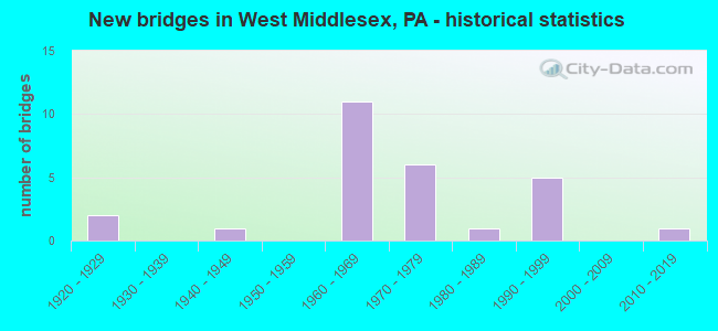
- New bridges - historical statistics
- 21920-1929
- 11940-1949
- 111960-1969
- 61970-1979
- 11980-1989
- 51990-1999
- 12010-2019

- Reconstructed bridges - Historical Statistics
- 11960-1969
- 01970-1979
- 11980-1989
- 11990-1999
- 02000-2009
- 12010-2019
- 22020-2022


- Bridge Condition - Deck
- 13.3%Excellent
- 6.7%Very good
- 26.7%Good
- 33.3%Satisfactory
- 13.3%Fair
- 6.7%Failed

- Bridge Condition - Superstructure
- 13.3%Excellent
- 33.3%Very good
- 6.7%Good
- 13.3%Satisfactory
- 26.7%Fair
- 6.7%Imminent failure

- Bridge Condition - Substructure
- 6.7%Excellent
- 26.7%Good
- 40.0%Satisfactory
- 20.0%Fair
- 6.7%Imminent failure

- Bridge Condition - Channel
- 10.0%Very good
- 40.0%Good
- 40.0%Satisfactory
- 10.0%Fair
Find on map >> Show street view
Structure Number: 25627, Location: SHENANGO TOWNSHIP (Lat: 41.162942, Lng: -80.441511), Route carried "on" structure: State highway 18, Year Built: 1990, Status: Open, Structure Length: 0.98m (3.22ft), Average Daily Traffic: 3,477 (year 2020), Truck Traffic: 9%, Average Future Daily Traffic: 6,211 (year 2032), Design Load: HS 25 or greater, Features Intersected: OVER POWELL RUN
Minimum Vertical Clearance: 30+ m (98+ ft), Kilometerpoint: 8.188, Lanes on structure: 2, Base Highway Network: Yes, Owner: State Highway Agency, Approaching Roadway Width: 9.4m (30.8ft), Skew: 2 degrees, Material/Design: Prestressed concrete, Design/Construction: Box Beam or Girders - Multiple, Number Of Spans In Main Unit: 1, Length of Maximum Span: 9.1m (29.9ft), Curb or Sidewalk Widths: Left: 0.2m (0.7ft), Right: 0.2m (0.7ft), Curb-To-Curb Width: 11.7m (38.4ft), Out-to-Out Width: 12.8m (42.0ft)
Condition: Deck: Good, Superstructure: Very good, Substructure: Good, Channel: Good, Inventory Rating: 53.5 metric tons, Method Used To Determine Inventory Rating: Load Factor (LF), Structural Evaluation: Better than present minimum criteria, Deck Geometry: Somewhat better than minimum adequacy, Waterway Adequacy: Somewhat better than minimum adequacy, Approach Roadway Alignment: Equal to present desirable criteria, Length Of Structure Improvement: 1.60m (5.25ft), Designated Inspection Frequency: Every 48 months, Inspection Date: November 2020, Deck Structure Type: Concrete Cast-file-Place, Wearing Surface/Protective System: Wearing Surface: Bituminous, Membrane: Preformed Fabric, Deck Protection: Epoxy Coated Reinforcing
Find on map >> Show street view
Structure Number: 25628, Location: SHENANGO TOWNSHIP (Lat: 41.182117, Lng: -80.455608), Route carried "on" structure: State highway 18, Year Built: 1941, Status: Open, Structure Length: 2.59m (8.50ft), Average Daily Traffic: 5,553 (year 2022), Truck Traffic: 11%, Average Future Daily Traffic: 8,852 (year 2032), Design Load: H 20, Features Intersected: OVER HOG BACK RUN
Minimum Vertical Clearance: 30+ m (98+ ft), Kilometerpoint: 10.741, Lanes on structure: 2, Base Highway Network: Yes, Owner: State Highway Agency, Approaching Roadway Width: 8.5m (27.9ft), Skew: 4 degrees, Material/Design: Concrete, Design/Construction: Tee Beam, Number Of Spans In Main Unit: 2, Length of Maximum Span: 12.5m (41.0ft), Curb-To-Curb Width: 10.4m (34.1ft), Out-to-Out Width: 11.5m (37.7ft)
Condition: Deck: Satisfactory, Superstructure: Fair, Substructure: Fair, Channel: Satisfactory, Operating Rating: 89.8 metric tons, Method Used To Determine Operating Rating: Load Factor (LF), Inventory Rating: 59.0 metric tons, Method Used To Determine Inventory Rating: Load Factor (LF), Structural Evaluation: Somewhat better than minimum adequacy, Deck Geometry: Meets minimum limits, Waterway Adequacy: Equal to present minimum criteria, Approach Roadway Alignment: Equal to present desirable criteria, Length Of Structure Improvement: 3.40m (11.15ft), Designated Inspection Frequency: Every 24 months, Inspection Date: April 2020, Bridge Improvement Cost: $18,000, Roadway Improvement Cost: $52,000, Total Project Cost: $238,000, Wearing Surface/Protective System: Wearing Surface: Bituminous
Find on map >> Show street view
Structure Number: 25685, Location: SHENANGO TOWNSHIP (Lat: 41.161383, Lng: -80.433053), Route carried "on" structure: Interstate 376, Year Built: 1974, Status: Open, Structure Length: 5.39m (17.68ft), Average Daily Traffic: 7,845 (year 2021), Truck Traffic: 12%, Average Future Daily Traffic: 9,827 (year 2032), Design Load: HS 20+Mod, Features Intersected: OVER SR 18 N/SB,NEW CAST, Facility Carried by Structure: SR 60,NB BEAVER
Minimum Vertical Clearance: 30+ m (98+ ft), Kilometerpoint: 2.424, Lanes on structure: 2, Lanes under structure: 6, Base Highway Network: Yes, Owner: State Highway Agency, Approaching Roadway Width: 12.2m (40.0ft), Skew: 10 degrees, Material/Design: Prestressed concrete, Design/Construction: Stringer/Multi-beam, Number Of Spans In Main Unit: 3, Length of Maximum Span: 31.4m (103.0ft), Curb or Sidewalk Widths: Left: 0.2m (0.7ft), Right: 0.2m (0.7ft), Curb-To-Curb Width: 11.7m (38.4ft), Out-to-Out Width: 13.4m (44.0ft)
Condition: Deck: Satisfactory, Superstructure: Good, Substructure: Satisfactory, Operating Rating: 82.6 metric tons, Method Used To Determine Operating Rating: Load Factor (LF), Inventory Rating: 29.0 metric tons, Method Used To Determine Inventory Rating: Load Factor (LF), Structural Evaluation: Equal to present minimum criteria, Deck Geometry: Equal to present minimum criteria, Underclear: Equal to present minimum criteria, Approach Roadway Alignment: Equal to present desirable criteria, Length Of Structure Improvement: 5.40m (17.72ft), Designated Inspection Frequency: Every 24 months, Inspection Date: April 2020, Bridge Improvement Cost: $8,000, Roadway Improvement Cost: $24,000, Total Project Cost: $109,000, Deck Structure Type: Concrete Cast-file-Place, Wearing Surface/Protective System: Wearing Surface: Bituminous, Membrane: Preformed Fabric
Find on map >> Show street view
Structure Number: 25687, Location: SHENANGO TOWNSHIP (Lat: 41.161394, Lng: -80.433361), Route carried "on" structure: Interstate 376, Year Built: 1974, Status: Open, Structure Length: 5.85m (19.19ft), Average Daily Traffic: 7,603 (year 2021), Truck Traffic: 12%, Average Future Daily Traffic: 9,739 (year 2032), Design Load: HS 20+Mod, Features Intersected: OVER SR 18,N/SB NEW CAST, Facility Carried by Structure: SR 60,SB BEAVER
Minimum Vertical Clearance: 30+ m (98+ ft), Kilometerpoint: 2.425, Lanes on structure: 2, Lanes under structure: 3, Base Highway Network: Yes, Owner: State Highway Agency, Approaching Roadway Width: 11.6m (38.1ft), Skew: 10 degrees, Material/Design: Prestressed concrete, Design/Construction: Stringer/Multi-beam, Number Of Spans In Main Unit: 3, Length of Maximum Span: 31.4m (103.0ft), Curb or Sidewalk Widths: Left: 0.2m (0.7ft), Right: 0.2m (0.7ft), Curb-To-Curb Width: 11.7m (38.4ft), Out-to-Out Width: 13.4m (44.0ft)
Condition: Deck: Satisfactory, Superstructure: Satisfactory, Substructure: Fair, Operating Rating: 86.2 metric tons, Method Used To Determine Operating Rating: Load Factor (LF), Inventory Rating: 15.4 metric tons, Method Used To Determine Inventory Rating: Load Factor (LF), Structural Evaluation: High priority of corrective action, Deck Geometry: Equal to present minimum criteria, Underclear: Superior to present desirable criteria, Approach Roadway Alignment: Equal to present desirable criteria, Length Of Structure Improvement: 5.90m (19.36ft), Designated Inspection Frequency: Every 24 months, Inspection Date: April 2020, Deck Structure Type: Concrete Cast-file-Place, Wearing Surface/Protective System: Wearing Surface: Bituminous, Membrane: Preformed Fabric
Find on map >> Show street view
Structure Number: 25688, Location: SHENANGO TOWNSHIP (Lat: 41.171781, Lng: -80.436578), Route carried "on" structure: Interstate 376, Year Built: 1966, Status: Open, Structure Length: 2.80m (9.19ft), Average Daily Traffic: 9,006 (year 2021), Truck Traffic: 12%, Average Future Daily Traffic: 9,827 (year 2032), Design Load: HS 20+Mod, Features Intersected: OVER T-369,HEWITT ROAD, Facility Carried by Structure: SR 60,NB BEAVER
Minimum Vertical Clearance: 30+ m (98+ ft), Kilometerpoint: 0.819, Lanes on structure: 2, Lanes under structure: 2, Base Highway Network: Yes, Owner: State Highway Agency, Approaching Roadway Width: 7.3m (24.0ft), Skew: 11 degrees, Material/Design: Concrete continuous, Design/Construction: Slab, Number Of Spans In Main Unit: 3, Length of Maximum Span: 11.6m (38.1ft), Curb or Sidewalk Widths: Left: 0.5m (1.6ft), Right: 0.5m (1.6ft), Curb-To-Curb Width: 11.6m (38.1ft), Out-to-Out Width: 13.4m (44.0ft)
Condition: Deck: Fair, Superstructure: Fair, Substructure: Satisfactory, Operating Rating: 54.4 metric tons, Method Used To Determine Operating Rating: Field evaluation and documented engineering judgment, Inventory Rating: 33.6 metric tons, Method Used To Determine Inventory Rating: Field evaluation and documented engineering judgment, Structural Evaluation: Somewhat better than minimum adequacy, Deck Geometry: Equal to present minimum criteria, Underclear: Somewhat better than minimum adequacy, Approach Roadway Alignment: Equal to present desirable criteria, Length Of Structure Improvement: 2.80m (9.19ft), Designated Inspection Frequency: Every 24 months, Inspection Date: September 2021, Bridge Improvement Cost: $22,000, Roadway Improvement Cost: $64,000, Total Project Cost: $294,000, Wearing Surface/Protective System: Wearing Surface: Bituminous, Membrane: Preformed Fabric
Find on map >> Show street view
Structure Number: 25689, Location: SHENANGO TOWNSHIP (Lat: 41.171869, Lng: -80.436956), Route carried "on" structure: Interstate 376, Year Built: 1966, Status: Open, Structure Length: 2.80m (9.19ft), Average Daily Traffic: 9,436 (year 2021), Truck Traffic: 10%, Average Future Daily Traffic: 9,739 (year 2032), Design Load: HS 20+Mod, Features Intersected: OVER T-369,HEWITT ROAD, Facility Carried by Structure: SR 60,SB BEAVER
Minimum Vertical Clearance: 30+ m (98+ ft), Kilometerpoint: 0.826, Lanes on structure: 2, Lanes under structure: 2, Base Highway Network: Yes, Owner: State Highway Agency, Approaching Roadway Width: 7.3m (24.0ft), Skew: 11 degrees, Material/Design: Concrete continuous, Design/Construction: Slab, Number Of Spans In Main Unit: 3, Length of Maximum Span: 11.6m (38.1ft), Curb or Sidewalk Widths: Left: 0.5m (1.6ft), Right: 0.5m (1.6ft), Curb-To-Curb Width: 11.6m (38.1ft), Out-to-Out Width: 13.4m (44.0ft)
Condition: Deck: Fair, Superstructure: Fair, Substructure: Satisfactory, Operating Rating: 54.4 metric tons, Method Used To Determine Operating Rating: Field evaluation and documented engineering judgment, Inventory Rating: 33.6 metric tons, Method Used To Determine Inventory Rating: Field evaluation and documented engineering judgment, Structural Evaluation: Somewhat better than minimum adequacy, Deck Geometry: Equal to present minimum criteria, Underclear: Better than present minimum criteria, Approach Roadway Alignment: Equal to present desirable criteria, Length Of Structure Improvement: 2.80m (9.19ft), Designated Inspection Frequency: Every 24 months, Inspection Date: September 2021, Bridge Improvement Cost: $6,000, Roadway Improvement Cost: $17,000, Total Project Cost: $79,000, Wearing Surface/Protective System: Wearing Surface: Bituminous, Membrane: Preformed Fabric
Find on map >> Show street view
Structure Number: 25691, Location: SHENANGO TOWNSHIP (Lat: 41.182944, Lng: -80.442214), Route carried "on" structure: Interstate 376, Year Built: 1966, Year Reconstructed: 2020, Status: Open, Structure Length: 0.73m (2.40ft), Average Daily Traffic: 17,637 (year 2021), Truck Traffic: 9%, Average Future Daily Traffic: 23,447 (year 2032), Design Load: HS 20+Mod, Features Intersected: OVER HOGBACK RUN, Facility Carried by Structure: SR 60,NB/SB BEAVER
Minimum Vertical Clearance: 30+ m (98+ ft), Kilometerpoint: 0.000, Lanes on structure: 6, Base Highway Network: Yes, Owner: State Highway Agency, Approaching Roadway Width: 32.9m (107.9ft), Skew: 22 degrees, Material/Design: Concrete, Design/Construction: Culvert, Number Of Spans In Main Unit: 1, Length of Maximum Span: 7.3m (24.0ft)
Condition: Channel: Satisfactory, Culverts: Satisfactory, Operating Rating: 89.8 metric tons, Method Used To Determine Operating Rating: Field evaluation and documented engineering judgment, Inventory Rating: 89.8 metric tons, Method Used To Determine Inventory Rating: Field evaluation and documented engineering judgment, Structural Evaluation: Equal to present minimum criteria, Waterway Adequacy: Superior to present desirable criteria, Approach Roadway Alignment: Equal to present desirable criteria, Length Of Structure Improvement: 1.40m (4.59ft), Designated Inspection Frequency: Every 24 months, Inspection Date: September 2021
Find on map >> Show street view
Structure Number: 25768, Location: SHENANGO TOWNSHIP (Lat: 41.182797, Lng: -80.470494), Route carried "on" structure: Interstate 80, Year Built: 1966, Year Reconstructed: 1994, Status: Open, Structure Length: 19.20m (62.99ft), Average Daily Traffic: 15,538 (year 2021), Truck Traffic: 42%, Average Future Daily Traffic: 16,055 (year 2032), Design Load: HS 20+Mod, Features Intersected: OVER ABANDON RR &SHNGO R
Minimum Vertical Clearance: 30+ m (98+ ft), Kilometerpoint: 4.088, Lanes on structure: 2, Base Highway Network: Yes, Owner: State Highway Agency, Approaching Roadway Width: 11.6m (38.1ft), Skew: 10 degrees, Material/Design: Prestressed concrete continuous, Design/Construction: Stringer/Multi-beam, Number Of Spans In Main Unit: 7, Length of Maximum Span: 33.5m (109.9ft), Curb or Sidewalk Widths: Left: 0.2m (0.7ft), Right: 0.2m (0.7ft), Curb-To-Curb Width: 10.4m (34.1ft), Out-to-Out Width: 11.5m (37.7ft)
Condition: Deck: Satisfactory, Superstructure: Satisfactory, Substructure: Satisfactory, Channel: Satisfactory, Operating Rating: 74.4 metric tons, Method Used To Determine Operating Rating: Load Factor (LF), Inventory Rating: 40.8 metric tons, Method Used To Determine Inventory Rating: Load Factor (LF), Structural Evaluation: Equal to present minimum criteria, Deck Geometry: Meets minimum limits, Waterway Adequacy: Superior to present desirable criteria, Approach Roadway Alignment: Equal to present desirable criteria, Length Of Structure Improvement: 19.80m (64.96ft), Designated Inspection Frequency: Every 48 months, Inspection Date: May 2020, Deck Structure Type: Concrete Cast-file-Place, Wearing Surface/Protective System: Wearing Surface: Bituminous, Membrane: Preformed Fabric, Deck Protection: Epoxy Coated Reinforcing
Find on map >> Show street view
Structure Number: 25771, Location: SHENANGO TOWNSHIP (Lat: 41.184439, Lng: -80.455697), Route carried "on" structure: Interstate 80, Year Built: 1993, Status: Open, Structure Length: 2.99m (9.81ft), Average Daily Traffic: 15,538 (year 2021), Truck Traffic: 42%, Average Future Daily Traffic: 16,055 (year 2032), Design Load: HS 20+Mod, Features Intersected: OVER SR 18,NEW CASTLE RD
Minimum Vertical Clearance: 30+ m (98+ ft), Kilometerpoint: 4.836, Lanes on structure: 2, Lanes under structure: 2, Base Highway Network: Yes, Owner: State Highway Agency, Approaching Roadway Width: 14.6m (47.9ft), Skew: 10 degrees, Material/Design: Prestressed concrete, Design/Construction: Stringer/Multi-beam, Number Of Spans In Main Unit: 1, Length of Maximum Span: 29.3m (96.1ft), Curb or Sidewalk Widths: Left: 0.2m (0.7ft), Right: 0.2m (0.7ft), Curb-To-Curb Width: 12.8m (42.0ft), Out-to-Out Width: 13.9m (45.6ft)
Condition: Deck: Good, Superstructure: Very good, Substructure: Good, Operating Rating: 84.4 metric tons, Method Used To Determine Operating Rating: Load Factor (LF), Inventory Rating: 40.8 metric tons, Method Used To Determine Inventory Rating: Load Factor (LF), Structural Evaluation: Better than present minimum criteria, Deck Geometry: Equal to present desirable criteria, Underclear: Superior to present desirable criteria, Approach Roadway Alignment: Equal to present desirable criteria, Length Of Structure Improvement: 3.70m (12.14ft), Designated Inspection Frequency: Every 48 months, Inspection Date: July 2019, Deck Structure Type: Concrete Cast-file-Place, Wearing Surface/Protective System: Wearing Surface: Bituminous, Membrane: Preformed Fabric, Deck Protection: Epoxy Coated Reinforcing
Find on map >> Show street view
Structure Number: 25773, Location: SHENANGO TOWNSHIP (Lat: 41.184739, Lng: -80.455861), Route carried "on" structure: Interstate 80, Year Built: 1994, Status: Open, Structure Length: 2.99m (9.81ft), Average Daily Traffic: 15,099 (year 2021), Truck Traffic: 42%, Average Future Daily Traffic: 17,350 (year 2032), Design Load: HS 20+Mod, Features Intersected: OVER SR 18,NEW CASTLE RD
Minimum Vertical Clearance: 30+ m (98+ ft), Kilometerpoint: 4.851, Lanes on structure: 2, Lanes under structure: 2, Base Highway Network: Yes, Owner: State Highway Agency, Approaching Roadway Width: 11.6m (38.1ft), Skew: 10 degrees, Material/Design: Prestressed concrete, Design/Construction: Stringer/Multi-beam, Number Of Spans In Main Unit: 1, Length of Maximum Span: 29.3m (96.1ft), Curb or Sidewalk Widths: Left: 0.2m (0.7ft), Right: 0.2m (0.7ft), Curb-To-Curb Width: 12.8m (42.0ft), Out-to-Out Width: 13.9m (45.6ft)
Condition: Deck: Good, Superstructure: Very good, Substructure: Good, Operating Rating: 84.4 metric tons, Method Used To Determine Operating Rating: Load Factor (LF), Inventory Rating: 40.8 metric tons, Method Used To Determine Inventory Rating: Load Factor (LF), Structural Evaluation: Better than present minimum criteria, Deck Geometry: Equal to present desirable criteria, Underclear: Superior to present desirable criteria, Approach Roadway Alignment: Equal to present desirable criteria, Length Of Structure Improvement: 3.70m (12.14ft), Designated Inspection Frequency: Every 48 months, Inspection Date: July 2019, Deck Structure Type: Concrete Cast-file-Place, Wearing Surface/Protective System: Wearing Surface: Bituminous, Membrane: Preformed Fabric, Deck Protection: Epoxy Coated Reinforcing
Find on map >> Show street view
Structure Number: 25857, Location: SHENANGO TOWNSHIP (Lat: 41.178119, Lng: -80.440111), Route carried "on" structure: State highway 318, Year Built: 1966, Status: Open, Structure Length: 6.64m (21.78ft), Average Daily Traffic: 2,872 (year 2021), Truck Traffic: 17%, Average Future Daily Traffic: 3,346 (year 2032), Design Load: HS 20, Features Intersected: OVER I-376,NB/SB BEAVER
Minimum Vertical Clearance: 30+ m (98+ ft), Kilometerpoint: 6.853, Lanes on structure: 2, Lanes under structure: 8, Owner: State Highway Agency, Approaching Roadway Width: 8.5m (27.9ft), Material/Design: Prestressed concrete, Design/Construction: Box Beam or Girders - Single/Spread, Number Of Spans In Main Unit: 4, Length of Maximum Span: 19.8m (65.0ft), Curb or Sidewalk Widths: Left: 0.5m (1.6ft), Right: 0.5m (1.6ft), Curb-To-Curb Width: 9.1m (29.9ft), Out-to-Out Width: 10.8m (35.4ft)
Condition: Deck: Satisfactory, Superstructure: Fair, Substructure: Satisfactory, Operating Rating: 39.0 metric tons, Method Used To Determine Operating Rating: Load Factor (LF), Inventory Rating: 22.7 metric tons, Method Used To Determine Inventory Rating: Load Factor (LF), Structural Evaluation: Somewhat better than minimum adequacy, Deck Geometry: Meets minimum limits, Underclear: High priority of corrective action, Approach Roadway Alignment: Equal to present desirable criteria, Length Of Structure Improvement: 7.70m (25.26ft), Designated Inspection Frequency: Every 24 months, Inspection Date: September 2020, Bridge Improvement Cost: $59,000, Roadway Improvement Cost: $172,000, Total Project Cost: $791,000, Deck Structure Type: Concrete Cast-file-Place, Wearing Surface/Protective System: Wearing Surface: Bituminous, Membrane: Other
Find on map >> Show street view
Structure Number: 25884, Location: SHENANGO TOWNSHIP (Lat: 41.130367, Lng: -80.430358), Route carried "on" structure: State highway 551, Year Built: 1989, Status: Open, Structure Length: 1.01m (3.31ft), Average Daily Traffic: 756 (year 2020), Truck Traffic: 7%, Average Future Daily Traffic: 908 (year 2032), Design Load: HS 25 or greater, Features Intersected: OVER BUCHANAN RUN TRIB
Minimum Vertical Clearance: 30+ m (98+ ft), Kilometerpoint: 0.589, Lanes on structure: 2, Owner: State Highway Agency, Approaching Roadway Width: 7.9m (25.9ft), Skew: 4 degrees, Material/Design: Prestressed concrete, Design/Construction: Box Beam or Girders - Single/Spread, Number Of Spans In Main Unit: 1, Length of Maximum Span: 9.4m (30.8ft), Curb or Sidewalk Widths: Left: 0.2m (0.7ft), Right: 0.2m (0.7ft), Curb-To-Curb Width: 8.5m (27.9ft), Out-to-Out Width: 9.4m (30.8ft)
Condition: Deck: Good, Superstructure: Very good, Substructure: Good, Channel: Satisfactory, Operating Rating: 89.8 metric tons, Method Used To Determine Operating Rating: Load Factor (LF), Inventory Rating: 46.3 metric tons, Method Used To Determine Inventory Rating: Load Factor (LF), Structural Evaluation: Better than present minimum criteria, Deck Geometry: Somewhat better than minimum adequacy, Waterway Adequacy: Equal to present minimum criteria, Approach Roadway Alignment: Equal to present desirable criteria, Length Of Structure Improvement: 0.90m (2.95ft), Designated Inspection Frequency: Every 48 months, Inspection Date: November 2019, Deck Structure Type: Concrete Cast-file-Place, Wearing Surface/Protective System: Wearing Surface: Bituminous, Membrane: Preformed Fabric, Deck Protection: Epoxy Coated Reinforcing
Find on map >> Show street view
Structure Number: 26254, Location: HEASLEY RD SHENANGO TWP (Lat: 41.137950, Lng: -80.426161), Route carried "on" structure: City street T303, Year Built: 1922, Year Reconstructed: 1960, Status: Closed, Structure Length: 0.67m (2.20ft), Average Daily Traffic: 89 (year 2015), Truck Traffic: 4%, Average Future Daily Traffic: 120 (year 2035), Design Load: HS 20, Features Intersected: OVER SHENANGO RIVER TRIB, Facility Carried by Structure: BRIDGE 2805,T-303
Minimum Vertical Clearance: 30+ m (98+ ft), Kilometerpoint: 0.000, Lanes on structure: 2, Owner: County Highway Agency, Approaching Roadway Width: 5.5m (18.0ft), Skew: 4 degrees, Material/Design: Steel, Design/Construction: Stringer/Multi-beam, Number Of Spans In Main Unit: 1, Length of Maximum Span: 6.1m (20.0ft), Curb-To-Curb Width: 6.2m (20.3ft), Out-to-Out Width: 6.7m (22.0ft)
Condition: Deck: Failed, Superstructure: Imminent failure, Substructure: Imminent failure, Channel: Good, Operating Rating: 1.8 metric tons, Method Used To Determine Operating Rating: Load Factor (LF), Inventory Rating: 0.9 metric tons, Method Used To Determine Inventory Rating: Load Factor (LF), Deck Geometry: Somewhat better than minimum adequacy, Waterway Adequacy: Equal to present desirable criteria, Approach Roadway Alignment: Better than present minimum criteria, Bridge Posting: Required (Relationship of Operating Rating to Maximum Legal Load: > 39.9% below), Length Of Structure Improvement: 0.60m (1.97ft), Designated Inspection Frequency: Every 24 months, Inspection Date: May 2020, Bridge Improvement Cost: $20,000, Roadway Improvement Cost: $72,000, Total Project Cost: $1,000, Deck Structure Type: Open Grating
Find on map >> Show street view
Structure Number: 26255, Location: CAMPGROUND, SHENANGO TWP (Lat: 41.137331, Lng: -80.452206), Route carried "on" structure: City street 7224, Year Built: 1966, Year Reconstructed: 2015, Status: Open, Structure Length: 1.16m (3.81ft), Average Daily Traffic: 58 (year 2019), Truck Traffic: 4%, Average Future Daily Traffic: 80 (year 2039), Design Load: HL 93, Features Intersected: OVER TURKEY RUN, Facility Carried by Structure: BRIDGE 2810,T-376
Minimum Vertical Clearance: 30+ m (98+ ft), Kilometerpoint: 0.000, Lanes on structure: 2, Owner: County Highway Agency, Approaching Roadway Width: 4.9m (16.1ft), Skew: 4 degrees, Material/Design: Steel, Design/Construction: Stringer/Multi-beam, Number Of Spans In Main Unit: 1, Length of Maximum Span: 11.0m (36.1ft), Curb-To-Curb Width: 7.3m (24.0ft), Out-to-Out Width: 7.9m (25.9ft)
Condition: Deck: Excellent, Superstructure: Excellent, Substructure: Fair, Channel: Good, Operating Rating: 81.0 metric tons, Method Used To Determine Operating Rating: Assigned ratings based on Load and Resistance Factor Design (LRFD) reported by rating factor (RF) using HL93 loadings, Inventory Rating: 62.2 metric tons, Method Used To Determine Inventory Rating: Assigned ratings based on Load and Resistance Factor Design (LRFD) reported by rating factor (RF) using HL93 loadings, Structural Evaluation: Somewhat better than minimum adequacy, Deck Geometry: Equal to present minimum criteria, Waterway Adequacy: Equal to present desirable criteria, Approach Roadway Alignment: Equal to present minimum criteria, Length Of Structure Improvement: 1.20m (3.94ft), Designated Inspection Frequency: Every 24 months, Inspection Date: November 2019, Total Project Cost: $1,204,000 ( Estimate for 2014), Deck Structure Type: Wood or Timber, Wearing Surface/Protective System: Wearing Surface: Bituminous, Membrane: Preformed Fabric
Find on map >> Show street view
Structure Number: 26261, Location: HAYWOOD ST.WEST MIDDLESEX (Lat: 41.178914, Lng: -80.451469), Route carried "on" structure: City street 7224, Year Built: 1928, Year Reconstructed: 2004, Status: Open, Structure Length: 1.46m (4.79ft), Average Daily Traffic: 46 (year 2018), Average Future Daily Traffic: 60 (year 2038), Design Load: H 10, Features Intersected: OVER HOGBACK RUN, Facility Carried by Structure: BRIDGE 2812,HAYWD
Minimum Vertical Clearance: 30+ m (98+ ft), Kilometerpoint: 0.000, Lanes on structure: 1, Owner: County Highway Agency, Approaching Roadway Width: 6.1m (20.0ft), Material/Design: Steel, Design/Construction: Stringer/Multi-beam, Number Of Spans In Main Unit: 1, Length of Maximum Span: 13.7m (44.9ft), Curb-To-Curb Width: 6.1m (20.0ft), Out-to-Out Width: 6.7m (22.0ft)
Condition: Deck: Very good, Superstructure: Very good, Substructure: Satisfactory, Channel: Good, Operating Rating: 89.8 metric tons, Method Used To Determine Operating Rating: Load Factor (LF), Inventory Rating: 69.9 metric tons, Method Used To Determine Inventory Rating: Load Factor (LF), Structural Evaluation: Equal to present minimum criteria, Deck Geometry: Somewhat better than minimum adequacy, Waterway Adequacy: Equal to present desirable criteria, Approach Roadway Alignment: Better than present minimum criteria, Length Of Structure Improvement: 1.50m (4.92ft), Designated Inspection Frequency: Every 24 months, Inspection Date: October 2020, Bridge Improvement Cost: $42,000, Roadway Improvement Cost: $122,000, Deck Structure Type: Wood or Timber, Wearing Surface/Protective System: Wearing Surface: Bituminous
Find on map >> Show street view
Structure Number: 26346, Location: SHENANGO TOWNSHIP (Lat: 41.183333, Lng: -80.443333), Route carried "on" structure: Ramp State highway , Year Built: 1966, Year Reconstructed: 2020, Status: Open, Structure Length: 0.82m (2.69ft), Average Daily Traffic: 1,937 (year 2021), Truck Traffic: 7%, Average Future Daily Traffic: 2,177 (year 2032), Design Load: HS 20+Mod, Features Intersected: OVER HOGBACK RUN, Facility Carried by Structure: RAMP C. SR 80WB
Minimum Vertical Clearance: 30+ m (98+ ft), Kilometerpoint: 0.000, Lanes on structure: 1, Base Highway Network: Yes, Owner: State Highway Agency, Approaching Roadway Width: 4.3m (14.1ft), Skew: 13 degrees, Material/Design: Concrete, Design/Construction: Culvert, Number Of Spans In Main Unit: 1, Length of Maximum Span: 8.2m (26.9ft)
Condition: Channel: Fair, Culverts: Satisfactory, Operating Rating: 75.3 metric tons, Method Used To Determine Operating Rating: Allowable Stress (AS), Inventory Rating: 45.4 metric tons, Method Used To Determine Inventory Rating: Allowable Stress (AS), Structural Evaluation: Equal to present minimum criteria, Waterway Adequacy: Superior to present desirable criteria, Approach Roadway Alignment: Equal to present desirable criteria, Length Of Structure Improvement: 1.40m (4.59ft), Designated Inspection Frequency: Every 24 months, Inspection Date: November 2021
Find on map >> Show street view
Structure Number: 56024, Location: WEST MIDDLESEX BOROUGH (Lat: 41.172378, Lng: -80.459611), Route carried "on" structure: State highway 318, Year Built: 2018, Status: Open, Structure Length: 7.13m (23.39ft), Average Daily Traffic: 4,065 (year 2022), Truck Traffic: 7%, Average Future Daily Traffic: 5,958 (year 2032), Design Load: HL 93, Features Intersected: SHENANGO RIVER
Minimum Vertical Clearance: 30+ m (98+ ft), Kilometerpoint: 4.633, Lanes on structure: 2, Owner: State Highway Agency, Approaching Roadway Width: 6.4m (21.0ft), Material/Design: Steel, Design/Construction: Stringer/Multi-beam, Number Of Spans In Main Unit: 1, Length of Maximum Span: 70.1m (230.0ft), Curb or Sidewalk Widths: Left: 0.2m (0.7ft), Right: 0.2m (0.7ft), Curb-To-Curb Width: 10.3m (33.8ft), Out-to-Out Width: 11.4m (37.4ft)
Condition: Deck: Excellent, Superstructure: Excellent, Substructure: Excellent, Channel: Very good, Operating Rating: 42.4 metric tons, Method Used To Determine Operating Rating: Assigned ratings based on Load and Resistance Factor Design (LRFD) reported by rating factor (RF) using HL93 loadings, Inventory Rating: 32.7 metric tons, Method Used To Determine Inventory Rating: Assigned ratings based on Load and Resistance Factor Design (LRFD) reported by rating factor (RF) using HL93 loadings, Structural Evaluation: Superior to present desirable criteria, Deck Geometry: Meets minimum limits, Waterway Adequacy: Superior to present desirable criteria, Approach Roadway Alignment: Equal to present desirable criteria, Designated Inspection Frequency: Every 24 months, Inspection Date: December 2020, Deck Structure Type: Concrete Cast-file-Place, Wearing Surface/Protective System: Wearing Surface: Monolithic Concrete, Membrane: Epoxy, Deck Protection: Epoxy Coated Reinforcing
Find on map >> Show street view
Structure Number: 25685, Location: SHENANGO TOWNSHIP (Lat: 41.161383, Lng: -80.433053), Route carried "under" structure: State highway 18, Year Built: 1974, Structure Length: 0. m, Average Daily Traffic: 1,912 (year 2022), Truck Traffic: 8%, Features Intersected: OVER SR 18 N/SB,NEW CAST, Facility Carried by Structure: SR 60,NB BEAVER
Minimum Vertical Clearance: 4.50m (14.76ft), Kilometerpoint: 7.194, Lanes on structure: 2, Lanes under structure: 3, Material/Design: Prestressed concrete, Design/Construction: Stringer/Multi-beam, Length of Maximum Span: 31.4m (103.0ft)
Find on map >> Show street view
Structure Number: 25685, Location: SHENANGO TOWNSHIP (Lat: 41.161383, Lng: -80.433053), Route carried "under" structure: State highway 18, Year Built: 1974, Structure Length: 0. m, Average Daily Traffic: 1,912 (year 2022), Truck Traffic: 8%, Features Intersected: OVER SR 18 N/SB,NEW CAST, Facility Carried by Structure: SR 60,NB BEAVER
Minimum Vertical Clearance: 4.52m (14.83ft), Kilometerpoint: 7.194, Lanes on structure: 2, Lanes under structure: 3, Material/Design: Prestressed concrete, Design/Construction: Stringer/Multi-beam, Length of Maximum Span: 31.4m (103.0ft)
Find on map >> Show street view
Structure Number: 25687, Location: SHENANGO TOWNSHIP (Lat: 41.161394, Lng: -80.433361), Route carried "under" structure: State highway 18, Year Built: 1974, Structure Length: 0. m, Average Daily Traffic: 1,912 (year 2022), Truck Traffic: 8%, Features Intersected: OVER SR 18,N/SB NEW CAST, Facility Carried by Structure: SR 60,SB BEAVER
Minimum Vertical Clearance: 2.62m (8.60ft), Kilometerpoint: 7.194, Lanes on structure: 2, Lanes under structure: 3, Material/Design: Prestressed concrete, Design/Construction: Stringer/Multi-beam, Length of Maximum Span: 31.4m (103.0ft)
Find on map >> Show street view
Structure Number: 25688, Location: SHENANGO TOWNSHIP (Lat: 41.171781, Lng: -80.436578), Route carried "under" structure: City street T369, Year Built: 1966, Structure Length: 0. m, Average Daily Traffic: 50 (year 2002), Features Intersected: OVER T-369,HEWITT ROAD, Facility Carried by Structure: SR 60,NB BEAVER
Minimum Vertical Clearance: 4.40m (14.44ft), Kilometerpoint: 0.000, Lanes on structure: 2, Lanes under structure: 2, Material/Design: Concrete continuous, Design/Construction: Slab, Length of Maximum Span: 11.6m (38.1ft)
Find on map >> Show street view
Structure Number: 25689, Location: SHENANGO TOWNSHIP (Lat: 41.171869, Lng: -80.436956), Route carried "under" structure: City street T369, Year Built: 1966, Structure Length: 0. m, Average Daily Traffic: 50 (year 2002), Features Intersected: OVER T-369,HEWITT ROAD, Facility Carried by Structure: SR 60,SB BEAVER
Minimum Vertical Clearance: 4.80m (15.75ft), Kilometerpoint: 0.000, Lanes on structure: 2, Lanes under structure: 2, Material/Design: Concrete continuous, Design/Construction: Slab, Length of Maximum Span: 11.6m (38.1ft)
Find on map >> Show street view
Structure Number: 25771, Location: SHENANGO TOWNSHIP (Lat: 41.184439, Lng: -80.455697), Route carried "under" structure: State highway 18, Year Built: 1993, Structure Length: 0. m, Average Daily Traffic: 5,553 (year 2022), Truck Traffic: 11%, Features Intersected: OVER SR 18,NEW CASTLE RD, Facility Carried by Structure: SR 80,EB
Minimum Vertical Clearance: 5.15m (16.90ft), Kilometerpoint: 10.741, Lanes on structure: 2, Lanes under structure: 2, Material/Design: Prestressed concrete, Design/Construction: Stringer/Multi-beam, Length of Maximum Span: 29.3m (96.1ft)
Find on map >> Show street view
Structure Number: 25773, Location: SHENANGO TOWNSHIP (Lat: 41.184739, Lng: -80.455861), Route carried "under" structure: State highway 18, Year Built: 1994, Structure Length: 0. m, Average Daily Traffic: 5,553 (year 2022), Truck Traffic: 11%, Features Intersected: OVER SR 18,NEW CASTLE RD, Facility Carried by Structure: SR 80,WB
Minimum Vertical Clearance: 5.28m (17.32ft), Kilometerpoint: 10.741, Lanes on structure: 2, Lanes under structure: 2, Material/Design: Prestressed concrete, Design/Construction: Stringer/Multi-beam, Length of Maximum Span: 29.3m (96.1ft)
Find on map >> Show street view
Structure Number: 25857, Location: SHENANGO TOWNSHIP (Lat: 41.178119, Lng: -80.440111), Route carried "under" structure: Interstate 376, Year Built: 1966, Structure Length: 0. m, Average Daily Traffic: 9,006 (year 2021), Truck Traffic: 12%, Features Intersected: OVER I-376,NB/SB BEAVER, Facility Carried by Structure: SR 318,MAIN ST
Minimum Vertical Clearance: 4.57m (14.99ft), Kilometerpoint: 0.819, Lanes on structure: 2, Lanes under structure: 4, Material/Design: Prestressed concrete, Design/Construction: Box Beam or Girders - Single/Spread, Length of Maximum Span: 19.8m (65.0ft)
Find on map >> Show street view
Structure Number: 25857, Location: SHENANGO TOWNSHIP (Lat: 41.178119, Lng: -80.440111), Route carried "under" structure: Interstate 376, Year Built: 1966, Structure Length: 0. m, Average Daily Traffic: 9,436 (year 2021), Truck Traffic: 10%, Features Intersected: OVER I-376,NB/SB BEAVER, Facility Carried by Structure: SR 318,MAIN ST
Minimum Vertical Clearance: 4.67m (15.32ft), Kilometerpoint: 0.826, Lanes on structure: 2, Lanes under structure: 4, Material/Design: Prestressed concrete, Design/Construction: Box Beam or Girders - Single/Spread, Length of Maximum Span: 19.8m (65.0ft)