Bridge Statistics for West Mayfield, Pennsylvania (PA)
Condition, Traffic, Stress, Structural Evaluation, Project Costs
- National Bridge Inventory (NBI) Statistics
- 13Number of bridges
- 59ft / 18.1mTotal length
- $1,402,000Total costs
- 83,535Total average daily traffic
- 5,855Total average daily truck traffic
- National Bridge Inventory (NBI) Registered Bridges for West Mayfield
- No street view available for this location
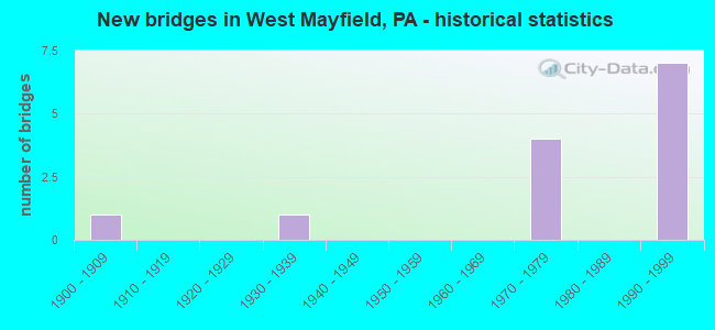
- New bridges - historical statistics
- 11900-1909
- 11930-1939
- 41970-1979
- 71990-1999


- Bridge Condition - Deck
- 20.0%Good
- 40.0%Satisfactory
- 20.0%Fair
- 20.0%Poor

- Bridge Condition - Superstructure
- 40.0%Good
- 20.0%Satisfactory
- 20.0%Fair
- 20.0%Poor

- Bridge Condition - Substructure
- 20.0%Good
- 40.0%Fair
- 40.0%Poor
Find on map >> Show street view
Structure Number: 3536, Location: 1/4 MI. SOUTH OF SR 0051 (Lat: 40.755989, Lng: -80.365481), Route carried "on" structure: Interstate 376, Year Built: 1971, Status: Open, Structure Length: 3.78m (12.40ft), Average Daily Traffic: 11,802 (year 2021), Truck Traffic: 10%, Average Future Daily Traffic: 12,435 (year 2032), Design Load: HS 20, Features Intersected: SR 4008
Minimum Vertical Clearance: 30+ m (98+ ft), Kilometerpoint: 0.402, Lanes on structure: 2, Lanes under structure: 2, Base Highway Network: Yes, Owner: State Highway Agency, Approaching Roadway Width: 11.9m (39.0ft), Skew: 10 degrees, Material/Design: Steel, Design/Construction: Stringer/Multi-beam, Number Of Spans In Main Unit: 1, Length of Maximum Span: 36.3m (119.1ft), Curb or Sidewalk Widths: Left: 0.2m (0.7ft), Right: 0.2m (0.7ft), Curb-To-Curb Width: 12.0m (39.4ft), Out-to-Out Width: 13.2m (43.3ft)
Condition: Deck: Satisfactory, Superstructure: Good, Substructure: Fair, Operating Rating: 99.8 metric tons, Method Used To Determine Operating Rating: Load Factor (LF), Inventory Rating: 59.9 metric tons, Method Used To Determine Inventory Rating: Load Factor (LF), Structural Evaluation: Somewhat better than minimum adequacy, Deck Geometry: Equal to present minimum criteria, Underclear: Somewhat better than minimum adequacy, Approach Roadway Alignment: Better than present minimum criteria, Length Of Structure Improvement: 4.70m (15.42ft), Designated Inspection Frequency: Every 24 months, Inspection Date: April 2021, Bridge Improvement Cost: $32,000, Roadway Improvement Cost: $95,000, Total Project Cost: $437,000, Deck Structure Type: Concrete Cast-file-Place, Wearing Surface/Protective System: Wearing Surface: Low Slump Concrete
Find on map >> Show street view
Structure Number: 3537, Location: 1/4 MI. SOUTH OF SR 0051 (Lat: 40.756033, Lng: -80.365756), Route carried "on" structure: Interstate 376, Year Built: 1971, Status: Open, Structure Length: 3.78m (12.40ft), Average Daily Traffic: 11,829 (year 2021), Truck Traffic: 11%, Average Future Daily Traffic: 11,828 (year 2032), Design Load: HS 20, Features Intersected: SR 4008
Minimum Vertical Clearance: 30+ m (98+ ft), Kilometerpoint: 0.393, Lanes on structure: 2, Lanes under structure: 2, Base Highway Network: Yes, Owner: State Highway Agency, Approaching Roadway Width: 11.9m (39.0ft), Skew: 10 degrees, Material/Design: Steel, Design/Construction: Stringer/Multi-beam, Number Of Spans In Main Unit: 1, Length of Maximum Span: 36.3m (119.1ft), Curb or Sidewalk Widths: Left: 0.2m (0.7ft), Right: 0.2m (0.7ft), Curb-To-Curb Width: 12.0m (39.4ft), Out-to-Out Width: 13.2m (43.3ft)
Condition: Deck: Satisfactory, Superstructure: Satisfactory, Substructure: Fair, Operating Rating: 99.8 metric tons, Method Used To Determine Operating Rating: Load Factor (LF), Inventory Rating: 59.9 metric tons, Method Used To Determine Inventory Rating: Load Factor (LF), Structural Evaluation: Somewhat better than minimum adequacy, Deck Geometry: Equal to present minimum criteria, Underclear: Superior to present desirable criteria, Approach Roadway Alignment: Equal to present desirable criteria, Length Of Structure Improvement: 4.70m (15.42ft), Designated Inspection Frequency: Every 24 months, Inspection Date: April 2021, Bridge Improvement Cost: $32,000, Roadway Improvement Cost: $95,000, Total Project Cost: $437,000, Deck Structure Type: Concrete Cast-file-Place, Wearing Surface/Protective System: Wearing Surface: Low Slump Concrete
Find on map >> Show street view
Structure Number: 3611, Location: 1700' W OF SR 0018 (Lat: 40.777997, Lng: -80.330797), Route carried "on" structure: State highway 251, Year Built: 1903, Year Reconstructed: 1945, Status: Open, Structure Length: 2.29m (7.51ft), Average Daily Traffic: 5,324 (year 2022), Truck Traffic: 1%, Average Future Daily Traffic: 8,053 (year 2032), Design Load: HS 20, Features Intersected: NORFOLK SOUTHERN RR, Facility Carried by Structure: BLACKHAWK ROAD
Minimum Vertical Clearance: 30+ m (98+ ft), Kilometerpoint: 18.132, Lanes on structure: 2, Owner: Railroad, Approaching Roadway Width: 7.9m (25.9ft), Material/Design: Steel, Design/Construction: Stringer/Multi-beam, Number Of Spans In Main Unit: 1, Length of Maximum Span: 21.3m (69.9ft), Curb or Sidewalk Widths: Left: 1.5m (4.9ft), Right: 1.5m (4.9ft), Curb-To-Curb Width: 7.9m (25.9ft), Out-to-Out Width: 11.7m (38.4ft)
Condition: Deck: Poor, Superstructure: Fair, Substructure: Poor, Operating Rating: 49.0 metric tons, Method Used To Determine Operating Rating: Load Factor (LF), Inventory Rating: 29.0 metric tons, Method Used To Determine Inventory Rating: Load Factor (LF), Structural Evaluation: Meets minimum limits, Deck Geometry: High priority of replacement, Underclear: High priority of corrective action, Approach Roadway Alignment: Equal to present desirable criteria, Length Of Structure Improvement: 2.30m (7.55ft), Designated Inspection Frequency: Every 24 months, Inspection Date: July 2021, Bridge Improvement Cost: $9,000, Roadway Improvement Cost: $27,000, Total Project Cost: $124,000, Deck Structure Type: Concrete Cast-file-Place, Wearing Surface/Protective System: Wearing Surface: Bituminous
Find on map >> Show street view
Structure Number: 3757, Location: 1/4 MI.EAST OF SR 4019 (Lat: 40.745203, Lng: -80.374789), Route carried "on" structure: State highway , Year Built: 1937, Status: Open, Structure Length: 0.73m (2.40ft), Average Daily Traffic: 519 (year 2022), Truck Traffic: 2%, Average Future Daily Traffic: 677 (year 2032), Design Load: HS 20, Features Intersected: N BR BRADYS RUN, Facility Carried by Structure: SHENANGO RD
Minimum Vertical Clearance: 30+ m (98+ ft), Kilometerpoint: 0.000, Lanes on structure: 2, Owner: State Highway Agency, Approaching Roadway Width: 7.3m (24.0ft), Material/Design: Concrete, Design/Construction: Tee Beam, Number Of Spans In Main Unit: 1, Length of Maximum Span: 6.1m (20.0ft), Curb or Sidewalk Widths: Left: 0.2m (0.7ft), Right: 0.2m (0.7ft), Curb-To-Curb Width: 7.2m (23.6ft), Out-to-Out Width: 7.9m (25.9ft)
Condition: Deck: Fair, Superstructure: Poor, Substructure: Poor, Channel: Satisfactory, Operating Rating: 47.2 metric tons, Method Used To Determine Operating Rating: Load Factor (LF), Inventory Rating: 28.1 metric tons, Method Used To Determine Inventory Rating: Load Factor (LF), Structural Evaluation: Meets minimum limits, Deck Geometry: Meets minimum limits, Waterway Adequacy: Better than present minimum criteria, Approach Roadway Alignment: Better than present minimum criteria, Length Of Structure Improvement: 1.40m (4.59ft), Designated Inspection Frequency: Every 24 months, Inspection Date: Febuary 2021, Bridge Improvement Cost: $30,000, Roadway Improvement Cost: $88,000, Total Project Cost: $404,000, Deck Structure Type: Concrete Cast-file-Place, Wearing Surface/Protective System: Wearing Surface: Bituminous
Find on map >> Show street view
Structure Number: 3795, Location: 1.3 MI E OF SHENANGO ROAD (Lat: 40.781622, Lng: -80.355858), Route carried "on" structure: State highway 251, Year Built: 1992, Status: Open, Structure Length: 7.47m (24.51ft), Average Daily Traffic: 5,324 (year 2022), Truck Traffic: 1%, Average Future Daily Traffic: 8,053 (year 2032), Design Load: HS 20, Features Intersected: BEAVER VAL EXPY TP, Facility Carried by Structure: 37TH STREET EXT
Minimum Vertical Clearance: 30+ m (98+ ft), Kilometerpoint: 15.620, Lanes on structure: 2, Lanes under structure: 4, Owner: State Highway Agency, Approaching Roadway Width: 12.8m (42.0ft), Material/Design: Steel continuous, Design/Construction: Stringer/Multi-beam, Number Of Spans In Main Unit: 2, Length of Maximum Span: 36.6m (120.1ft), Curb or Sidewalk Widths: Left: 0.2m (0.7ft), Right: 0.2m (0.7ft), Curb-To-Curb Width: 12.2m (40.0ft), Out-to-Out Width: 13.3m (43.6ft)
Condition: Deck: Good, Superstructure: Good, Substructure: Good, Operating Rating: 82.6 metric tons, Method Used To Determine Operating Rating: Load Factor (LF), Inventory Rating: 49.0 metric tons, Method Used To Determine Inventory Rating: Load Factor (LF), Structural Evaluation: Better than present minimum criteria, Deck Geometry: Somewhat better than minimum adequacy, Underclear: Better than present minimum criteria, Approach Roadway Alignment: Equal to present desirable criteria, Length Of Structure Improvement: 7.50m (24.61ft), Designated Inspection Frequency: Every 48 months, Inspection Date: September 2019, Deck Structure Type: Concrete Cast-file-Place, Wearing Surface/Protective System: Wearing Surface: Monolithic Concrete, Deck Protection: Epoxy Coated Reinforcing
Find on map >> Show street view
Structure Number: 3536, Location: 1/4 MI. SOUTH OF SR 0051 (Lat: 40.755989, Lng: -80.365481), Route carried "under" structure: State highway , Year Built: 1971, Structure Length: 0. m, Average Daily Traffic: 1,953 (year 2022), Truck Traffic: 1%, Features Intersected: SR 4008, Facility Carried by Structure: SR 0376 EB WB
Minimum Vertical Clearance: 4.37m (14.34ft), Kilometerpoint: 0.000, Lanes on structure: 2, Lanes under structure: 2, Material/Design: Steel, Design/Construction: Stringer/Multi-beam, Length of Maximum Span: 36.3m (119.1ft)
Find on map >> Show street view
Structure Number: 3537, Location: 1/4 MI. SOUTH OF SR 0051 (Lat: 40.756033, Lng: -80.365756), Route carried "under" structure: State highway , Year Built: 1971, Structure Length: 0. m, Average Daily Traffic: 1,953 (year 2022), Truck Traffic: 1%, Features Intersected: SR 4008, Facility Carried by Structure: SR 0376 EB WB
Minimum Vertical Clearance: 5.72m (18.77ft), Kilometerpoint: 0.000, Lanes on structure: 2, Lanes under structure: 2, Material/Design: Steel, Design/Construction: Stringer/Multi-beam, Length of Maximum Span: 36.3m (119.1ft)
Find on map >> Show street view
Structure Number: 3792, Location: CHIPPEWA TWP (Lat: 40.763817, Lng: -80.362247), Route carried "under" structure: State highway 51, Year Built: 1992, Structure Length: 0. m, Average Daily Traffic: 6,051 (year 2022), Truck Traffic: 2%, Features Intersected: SR 0051, Facility Carried by Structure: PA TPK (I-376)
Minimum Vertical Clearance: 10.12m (33.20ft), Kilometerpoint: 26.833, Lanes on structure: 2, Lanes under structure: 2, Material/Design: Steel continuous, Design/Construction: Stringer/Multi-beam, Length of Maximum Span: 34.4m (112.9ft)
Find on map >> Show street view
Structure Number: 3792, Location: CHIPPEWA TWP (Lat: 40.763817, Lng: -80.362247), Route carried "under" structure: State highway 51, Year Built: 1992, Structure Length: 0. m, Average Daily Traffic: 5,929 (year 2022), Truck Traffic: 4%, Features Intersected: SR 0051, Facility Carried by Structure: PA TPK (I-376)
Minimum Vertical Clearance: 10.13m (33.23ft), Kilometerpoint: 26.833, Lanes on structure: 2, Lanes under structure: 3, Material/Design: Steel continuous, Design/Construction: Stringer/Multi-beam, Length of Maximum Span: 34.4m (112.9ft)
Find on map >> Show street view
Structure Number: 3793, Location: CHIPPEWA TWP (Lat: 40.764053, Lng: -80.362550), Route carried "under" structure: State highway 51, Year Built: 1992, Structure Length: 0. m, Average Daily Traffic: 6,051 (year 2022), Truck Traffic: 2%, Features Intersected: SR 0051, Facility Carried by Structure: PA TPK (I-376)
Minimum Vertical Clearance: 8.73m (28.64ft), Kilometerpoint: 26.833, Lanes on structure: 2, Lanes under structure: 2, Material/Design: Steel continuous, Design/Construction: Stringer/Multi-beam, Length of Maximum Span: 34.4m (112.9ft)
Find on map >> Show street view
Structure Number: 3793, Location: CHIPPEWA TWP (Lat: 40.764053, Lng: -80.362550), Route carried "under" structure: State highway 51, Year Built: 1992, Structure Length: 0. m, Average Daily Traffic: 5,929 (year 2022), Truck Traffic: 4%, Features Intersected: SR 0051, Facility Carried by Structure: PA TPK (I-376)
Minimum Vertical Clearance: 8.80m (28.87ft), Kilometerpoint: 26.833, Lanes on structure: 2, Lanes under structure: 3, Material/Design: Steel continuous, Design/Construction: Stringer/Multi-beam, Length of Maximum Span: 34.4m (112.9ft)
Find on map >> Show street view
Structure Number: 3794, Location: 0.6 MI E OF SR 0051 (Lat: 40.767983, Lng: -80.360367), Route carried "under" structure: Interstate 376, Year Built: 1992, Structure Length: 0. m, Average Daily Traffic: 9,871 (year 1998), Truck Traffic: 12%, Features Intersected: PA TURNPIKE (376 EB-WB), Facility Carried by Structure: DARLINGTON ROAD
Minimum Vertical Clearance: 12.65m (41.50ft), Kilometerpoint: 0.000, Lanes on structure: 2, Lanes under structure: 6, Material/Design: Steel continuous, Design/Construction: Stringer/Multi-beam, Length of Maximum Span: 56.7m (186.0ft)
Find on map >> Show street view
Structure Number: 3795, Location: 1.3 MI E OF SHENANGO ROAD (Lat: 40.781622, Lng: -80.355858), Route carried "under" structure: State highway 60, Year Built: 1992, Structure Length: 0. m, Average Daily Traffic: 11,000 (year 2005), Truck Traffic: 12%, Features Intersected: BEAVER VAL EXPY TP, Facility Carried by Structure: 37TH STREET EXT
Minimum Vertical Clearance: 8.94m (29.33ft), Kilometerpoint: 0.000, Lanes on structure: 2, Lanes under structure: 4, Material/Design: Steel continuous, Design/Construction: Stringer/Multi-beam, Length of Maximum Span: 36.6m (120.1ft)