Bridge Statistics for West Marion, North Carolina (NC)
Condition, Traffic, Stress, Structural Evaluation, Project Costs
- National Bridge Inventory (NBI) Statistics
- 13Number of bridges
- 105ft / 32.4mTotal length
- 91,080Total average daily traffic
- 14,552Total average daily truck traffic
- National Bridge Inventory (NBI) Registered Bridges for West Marion
- No street view available for this location
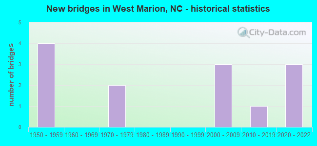
- New bridges - historical statistics
- 41950-1959
- 21970-1979
- 32000-2009
- 12010-2019
- 32020-2022


- Bridge Condition - Deck
- 40.0%Very good
- 20.0%Good
- 40.0%Satisfactory

- Bridge Condition - Superstructure
- 40.0%Very good
- 40.0%Good
- 20.0%Fair

- Bridge Condition - Substructure
- 40.0%Very good
- 20.0%Good
- 20.0%Satisfactory
- 20.0%Fair

- Bridge Condition - Channel
- 50.0%Good
- 33.3%Satisfactory
- 16.7%Fair

- Bridge Condition - Culverts
- 75.0%Good
- 25.0%Fair
Find on map >> Show street view
Structure Number: 1110013, Location: .7 MI.E.JCT.SR1163 (Lat: 35.586261, Lng: -82.004986), Route carried "on" structure: State highway 1351, Year Built: 2004, Status: Open, Structure Length: 1.28m (4.20ft), Average Daily Traffic: 1,200 (year 2018), Truck Traffic: 7%, Average Future Daily Traffic: 2,400 (year 2040), Design Load: HS 20+Mod, Features Intersected: SECOND BROAD RIVER
Minimum Vertical Clearance: 30+ m (98+ ft), Kilometerpoint: 0.000, Lanes on structure: 2, Owner: State Highway Agency, Approaching Roadway Width: 7.3m (24.0ft), Skew: 3 degrees, Material/Design: Concrete continuous, Design/Construction: Culvert, Number Of Spans In Main Unit: 3, Length of Maximum Span: 3.6m (11.8ft)
Condition: Channel: Satisfactory, Culverts: Good, Operating Rating: 50.8 metric tons, Method Used To Determine Operating Rating: Load and Resistance Factor (LRFR), Inventory Rating: 39.0 metric tons, Method Used To Determine Inventory Rating: Load and Resistance Factor (LRFR), Structural Evaluation: Better than present minimum criteria, Waterway Adequacy: Better than present minimum criteria, Approach Roadway Alignment: Equal to present desirable criteria, Designated Inspection Frequency: Every 24 months, Inspection Date: April 2020
Find on map >> Show street view
Structure Number: 1110022, Location: .1 MI.S.JCT.SR1163 (Lat: 35.597239, Lng: -82.029814), Route carried "on" structure: State highway 1001, Year Built: 2017, Status: Open, Structure Length: 3.10m (10.17ft), Average Daily Traffic: 1,500 (year 2015), Truck Traffic: 7%, Average Future Daily Traffic: 3,000 (year 2040), Design Load: HL 93, Features Intersected: SECOND BROAD RIVER
Minimum Vertical Clearance: 30+ m (98+ ft), Kilometerpoint: 0.000, Lanes on structure: 2, Owner: State Highway Agency, Approaching Roadway Width: 7.9m (25.9ft), Skew: 1 degrees, Material/Design: Prestressed concrete, Design/Construction: Box Beam or Girders - Multiple, Number Of Spans In Main Unit: 1, Length of Maximum Span: 30.1m (98.8ft), Curb-To-Curb Width: 8.3m (27.2ft), Out-to-Out Width: 9.1m (29.9ft)
Condition: Deck: Very good, Superstructure: Very good, Substructure: Very good, Channel: Satisfactory, Operating Rating: 69.8 metric tons, Method Used To Determine Operating Rating: Load and Resistance Factor (LRFR), Inventory Rating: 47.1 metric tons, Method Used To Determine Inventory Rating: Load and Resistance Factor (LRFR), Structural Evaluation: Equal to present desirable criteria, Deck Geometry: Meets minimum limits, Waterway Adequacy: Equal to present desirable criteria, Approach Roadway Alignment: Equal to present desirable criteria, Designated Inspection Frequency: Every 24 months, Inspection Date: January 2021, Deck Structure Type: Concrete Precast Panels, Wearing Surface/Protective System: Wearing Surface: Bituminous
Find on map >> Show street view
Structure Number: 1110039, Location: .1 MI.S.JCT.SR1152 (Lat: 35.609947, Lng: -81.995603), Route carried "on" structure: State highway 1147, Year Built: 1975, Status: Open, Structure Length: 0.67m (2.20ft), Average Daily Traffic: 680 (year 2013), Truck Traffic: 6%, Average Future Daily Traffic: 1,360 (year 2040), Design Load: HS 20+Mod, Features Intersected: GOOSE CREEK
Minimum Vertical Clearance: 30+ m (98+ ft), Kilometerpoint: 0.000, Lanes on structure: 2, Owner: State Highway Agency, Approaching Roadway Width: 5.4m (17.7ft), Material/Design: Steel, Design/Construction: Culvert, Number Of Spans In Main Unit: 2, Length of Maximum Span: 2.7m (8.9ft)
Condition: Channel: Fair, Culverts: Fair, Operating Rating: 89.8 metric tons, Method Used To Determine Operating Rating: Load and Resistance Factor (LRFR), Inventory Rating: 89.8 metric tons, Method Used To Determine Inventory Rating: Load and Resistance Factor (LRFR), Structural Evaluation: Somewhat better than minimum adequacy, Waterway Adequacy: Somewhat better than minimum adequacy, Approach Roadway Alignment: Equal to present desirable criteria, Designated Inspection Frequency: Every 24 months, Underwater Inspection Frequency: Every 60 months, Inspection Date: April 2020, Underwater Inspection Date: April 2020
Find on map >> Show street view
Structure Number: 1110041, Location: .2 MI.N.JCT.SR1148 (Lat: 35.581192, Lng: -81.994561), Route carried "on" structure: State highway 1147, Year Built: 2000, Status: Open, Structure Length: 1.31m (4.30ft), Average Daily Traffic: 530 (year 2018), Truck Traffic: 6%, Average Future Daily Traffic: 1,060 (year 2040), Design Load: HS 20+Mod, Features Intersected: SECOND BROAD RIVER
Minimum Vertical Clearance: 30+ m (98+ ft), Kilometerpoint: 0.000, Lanes on structure: 2, Owner: State Highway Agency, Approaching Roadway Width: 7.0m (23.0ft), Skew: 3 degrees, Material/Design: Concrete continuous, Design/Construction: Culvert, Number Of Spans In Main Unit: 3, Length of Maximum Span: 3.6m (11.8ft)
Condition: Channel: Good, Culverts: Good, Operating Rating: 52.6 metric tons, Method Used To Determine Operating Rating: Load and Resistance Factor (LRFR), Inventory Rating: 40.8 metric tons, Method Used To Determine Inventory Rating: Load and Resistance Factor (LRFR), Structural Evaluation: Better than present minimum criteria, Waterway Adequacy: Better than present minimum criteria, Approach Roadway Alignment: Equal to present desirable criteria, Designated Inspection Frequency: Every 24 months, Inspection Date: April 2020
Find on map >> Show street view
Structure Number: 1110042, Location: .4 MI.N.JCT.SR1135 (Lat: 35.589558, Lng: -82.018739), Route carried "on" structure: State highway 1163, Year Built: 2009, Status: Open, Structure Length: 1.18m (3.87ft), Average Daily Traffic: 640 (year 2014), Truck Traffic: 6%, Average Future Daily Traffic: 1,280 (year 2025), Design Load: HS 20+Mod, Features Intersected: SECOND BROAD RIVER
Minimum Vertical Clearance: 30+ m (98+ ft), Kilometerpoint: 0.000, Lanes on structure: 2, Owner: State Highway Agency, Approaching Roadway Width: 8.5m (27.9ft), Skew: 3 degrees, Material/Design: Concrete, Design/Construction: Culvert, Number Of Spans In Main Unit: 1, Length of Maximum Span: 9.7m (31.8ft)
Condition: Channel: Good, Culverts: Good, Operating Rating: 41.7 metric tons, Method Used To Determine Operating Rating: Field evaluation and documented engineering judgment, Inventory Rating: 32.6 metric tons, Method Used To Determine Inventory Rating: Field evaluation and documented engineering judgment, Structural Evaluation: Better than present minimum criteria, Waterway Adequacy: Equal to present desirable criteria, Approach Roadway Alignment: Equal to present desirable criteria, Designated Inspection Frequency: Every 24 months, Inspection Date: Febuary 2022
Find on map >> Show street view
Structure Number: 1110121, Location: 0.1 MI.N.JCT.SR1137 (Lat: 35.636311, Lng: -82.066208), Route carried "on" structure: State highway 1191, Year Built: 1958, Status: Open, Structure Length: 6.85m (22.47ft), Average Daily Traffic: 2,100 (year 2013), Truck Traffic: 7%, Average Future Daily Traffic: 4,200 (year 2040), Design Load: HS 15, Features Intersected: I-40
Minimum Vertical Clearance: 30+ m (98+ ft), Kilometerpoint: 0.000, Lanes on structure: 2, Lanes under structure: 4, Owner: State Highway Agency, Approaching Roadway Width: 6.7m (22.0ft), Skew: 2 degrees, Material/Design: Steel, Design/Construction: Stringer/Multi-beam, Number Of Spans In Main Unit: 4, Length of Maximum Span: 17.3m (56.8ft), Curb or Sidewalk Widths: Left: 0.4m (1.3ft), Right: 0.4m (1.3ft), Curb-To-Curb Width: 8.5m (27.9ft), Out-to-Out Width: 10.2m (33.5ft)
Condition: Deck: Satisfactory, Superstructure: Good, Substructure: Good, Operating Rating: 65.3 metric tons, Method Used To Determine Operating Rating: Load Factor (LF), Inventory Rating: 39.0 metric tons, Method Used To Determine Inventory Rating: Load Factor (LF), Structural Evaluation: Better than present minimum criteria, Deck Geometry: Meets minimum limits, Underclear: High priority of corrective action, Approach Roadway Alignment: Equal to present desirable criteria, Designated Inspection Frequency: Every 24 months, Inspection Date: March 2020, Deck Structure Type: Concrete Cast-file-Place, Wearing Surface/Protective System: Wearing Surface: Bituminous
Find on map >> Show street view
Structure Number: 1110128, Location: 0.15 MI.S.JCT.SR1190 (Lat: 35.646414, Lng: -82.035581), Route carried "on" structure: State highway 1001, Year Built: 2021, Status: Open, Structure Length: 6.76m (22.18ft), Average Daily Traffic: 16,000 (year 2019), Truck Traffic: 7%, Average Future Daily Traffic: 32,000 (year 2040), Design Load: HL 93, Features Intersected: I-40
Minimum Vertical Clearance: 30+ m (98+ ft), Kilometerpoint: 0.000, Lanes on structure: 2, Lanes under structure: 4, Owner: State Highway Agency, Approaching Roadway Width: 8.8m (28.9ft), Skew: 4 degrees, Material/Design: Prestressed concrete, Design/Construction: Stringer/Multi-beam, Number Of Spans In Main Unit: 2, Length of Maximum Span: 34.7m (113.8ft), Curb or Sidewalk Widths: Left: 1.6m (5.2ft), Right: 0.0m, Curb-To-Curb Width: 7.1m (23.3ft), Out-to-Out Width: 9.2m (30.2ft)
Condition: Deck: Very good, Superstructure: Very good, Substructure: Very good, Operating Rating: 81.6 metric tons, Method Used To Determine Operating Rating: Load and Resistance Factor (LRFR), Inventory Rating: 48.9 metric tons, Method Used To Determine Inventory Rating: Load and Resistance Factor (LRFR), Structural Evaluation: Equal to present desirable criteria, Deck Geometry: High priority of replacement, Underclear: High priority of corrective action, Approach Roadway Alignment: Equal to present desirable criteria, Designated Inspection Frequency: Every 24 months, Inspection Date: August 2021, Deck Structure Type: Concrete Cast-file-Place, Wearing Surface/Protective System: Wearing Surface: Monolithic Concrete
Find on map >> Show street view
Structure Number: 1110132, Location: 0.1 MI.WS.JCT.SR1285 (Lat: 35.633703, Lng: -82.001411), Route carried "on" structure: State highway 1168, Year Built: 1958, Status: Open, Structure Length: 8.44m (27.69ft), Average Daily Traffic: 1,200 (year 2017), Truck Traffic: 7%, Average Future Daily Traffic: 2,400 (year 2040), Design Load: HS 15, Features Intersected: I-40
Minimum Vertical Clearance: 30+ m (98+ ft), Kilometerpoint: 0.000, Lanes on structure: 2, Lanes under structure: 4, Owner: State Highway Agency, Approaching Roadway Width: 7.3m (24.0ft), Skew: 4 degrees, Material/Design: Steel, Design/Construction: Stringer/Multi-beam, Number Of Spans In Main Unit: 4, Length of Maximum Span: 21.9m (71.9ft), Curb or Sidewalk Widths: Left: 0.4m (1.3ft), Right: 0.4m (1.3ft), Curb-To-Curb Width: 8.5m (27.9ft), Out-to-Out Width: 10.1m (33.1ft)
Condition: Deck: Good, Superstructure: Good, Substructure: Satisfactory, Operating Rating: 66.2 metric tons, Method Used To Determine Operating Rating: Load Factor (LF), Inventory Rating: 39.9 metric tons, Method Used To Determine Inventory Rating: Load Factor (LF), Structural Evaluation: Equal to present minimum criteria, Deck Geometry: Somewhat better than minimum adequacy, Underclear: High priority of corrective action, Approach Roadway Alignment: Equal to present desirable criteria, Designated Inspection Frequency: Every 24 months, Inspection Date: March 2020, Deck Structure Type: Concrete Cast-file-Place, Wearing Surface/Protective System: Wearing Surface: Bituminous
Find on map >> Show street view
Structure Number: 1110343, Location: .01 MI.S.JCT.SR1153 (Lat: 35.619775, Lng: -82.016767), Route carried "on" structure: State highway 1154, Year Built: 1977, Status: Open, Structure Length: 2.77m (9.09ft), Average Daily Traffic: 230 (year 2000), Truck Traffic: 6%, Average Future Daily Traffic: 460 (year 2040), Design Load: HS 15, Features Intersected: GOOSE CREEK
Minimum Vertical Clearance: 30+ m (98+ ft), Kilometerpoint: 0.000, Lanes on structure: 2, Owner: State Highway Agency, Approaching Roadway Width: 5.7m (18.7ft), Skew: 3 degrees, Material/Design: Prestressed concrete, Design/Construction: Slab, Number Of Spans In Main Unit: 3, Length of Maximum Span: 8.8m (28.9ft), Curb-To-Curb Width: 7.2m (23.6ft), Out-to-Out Width: 7.5m (24.6ft)
Condition: Deck: Satisfactory, Superstructure: Fair, Substructure: Fair, Channel: Good, Operating Rating: 68.0 metric tons, Method Used To Determine Operating Rating: Load Factor (LF), Inventory Rating: 40.8 metric tons, Method Used To Determine Inventory Rating: Load Factor (LF), Structural Evaluation: Somewhat better than minimum adequacy, Deck Geometry: Meets minimum limits, Waterway Adequacy: Equal to present minimum criteria, Approach Roadway Alignment: Equal to present minimum criteria, Designated Inspection Frequency: Every 24 months, Inspection Date: May 2020, Deck Structure Type: Concrete Precast Panels, Wearing Surface/Protective System: Wearing Surface: Bituminous
Find on map >> Show street view
Structure Number: 1110128, Location: 0.15 MI.S.JCT.SR1190 (Lat: 35.646414, Lng: -82.035581), Route carried "under" structure: Interstate 40, Year Built: 2021, Structure Length: 0. m, Average Daily Traffic: 18,000 (year 2019), Truck Traffic: 16%, Features Intersected: SR1001
Minimum Vertical Clearance: 6.67m (21.88ft), Kilometerpoint: 24.811, Lanes on structure: 2, Lanes under structure: 2, Material/Design: Prestressed concrete, Design/Construction: Stringer/Multi-beam, Length of Maximum Span: 34.7m (113.8ft)
Find on map >> Show street view
Structure Number: 1110128, Location: 0.15 MI.S.JCT.SR1190 (Lat: 35.646414, Lng: -82.035581), Route carried "under" structure: Interstate 40, Year Built: 2021, Structure Length: 0. m, Average Daily Traffic: 18,000 (year 2019), Truck Traffic: 16%, Features Intersected: SR1001
Minimum Vertical Clearance: 6.45m (21.16ft), Kilometerpoint: 24.811, Lanes on structure: 2, Lanes under structure: 2, Material/Design: Prestressed concrete, Design/Construction: Stringer/Multi-beam, Length of Maximum Span: 34.7m (113.8ft)
Find on map >> Show street view
Structure Number: 1110132, Location: 0.1 MI.WS.JCT.SR1285 (Lat: 35.633703, Lng: -82.001411), Route carried "under" structure: Interstate 40, Year Built: 1958, Structure Length: 0. m, Average Daily Traffic: 15,500 (year 2018), Truck Traffic: 23%, Features Intersected: SR1168
Minimum Vertical Clearance: 5.41m (17.75ft), Kilometerpoint: 25.457, Lanes on structure: 2, Lanes under structure: 2, Material/Design: Steel, Design/Construction: Stringer/Multi-beam, Length of Maximum Span: 21.9m (71.9ft)
Find on map >> Show street view
Structure Number: 1110132, Location: 0.1 MI.WS.JCT.SR1285 (Lat: 35.633703, Lng: -82.001411), Route carried "under" structure: Interstate 40, Year Built: 1958, Structure Length: 0. m, Average Daily Traffic: 15,500 (year 2018), Truck Traffic: 23%, Features Intersected: SR1168
Minimum Vertical Clearance: 5.10m (16.73ft), Kilometerpoint: 25.457, Lanes on structure: 2, Lanes under structure: 2, Material/Design: Steel, Design/Construction: Stringer/Multi-beam, Length of Maximum Span: 21.9m (71.9ft)