Bridge Statistics for West Linn, Oregon (OR)
Condition, Traffic, Stress, Structural Evaluation, Project Costs
- National Bridge Inventory (NBI) Statistics
- 26Number of bridges
- 617ft / 188mTotal length
- $2,613,000Total costs
- 831,544Total average daily traffic
- 78,465Total average daily truck traffic
- National Bridge Inventory (NBI) Registered Bridges for West Linn
- No street view available for this location
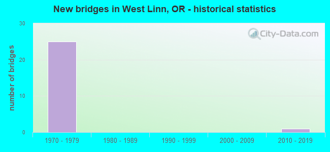
- New bridges - historical statistics
- 251970-1979
- 12010-2019
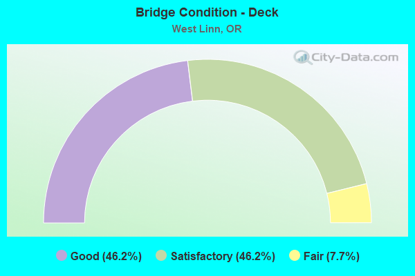
- Bridge Condition - Deck
- 46.2%Good
- 46.2%Satisfactory
- 7.7%Fair
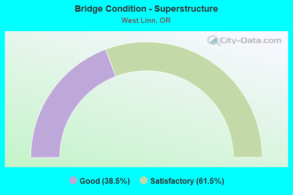
- Bridge Condition - Superstructure
- 38.5%Good
- 61.5%Satisfactory
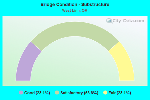
- Bridge Condition - Substructure
- 23.1%Good
- 53.8%Satisfactory
- 23.1%Fair
Find on map >> Show street view
Structure Number: 1654A003 00354, Location: 0.2 MI FROM WILLAMETTE R. (Lat: 45.339508, Lng: -122.654678), Route carried "on" structure: County highway 9585, Year Built: 1977, Status: Open, Structure Length: 12.01m (39.40ft), Average Daily Traffic: 2,060 (year 2020), Truck Traffic: 14%, Average Future Daily Traffic: 2,090 (year 2025), Design Load: HS 20, Features Intersected: TUALATIN RIVER, Facility Carried by Structure: PETES MOUNTAIN RD
Minimum Vertical Clearance: 30+ m (98+ ft), Kilometerpoint: 5.504, Lanes on structure: 2, Owner: County Highway Agency, Approaching Roadway Width: 8.2m (26.9ft), Material/Design: Prestressed concrete, Design/Construction: Stringer/Multi-beam, Number Of Spans In Main Unit: 3, Length of Maximum Span: 39.6m (129.9ft), Curb or Sidewalk Widths: Left: 1.8m (5.9ft), Right: 0.0m, Curb-To-Curb Width: 9.9m (32.5ft), Out-to-Out Width: 12.5m (41.0ft)
Condition: Deck: Satisfactory, Superstructure: Good, Substructure: Fair, Channel: Good, Operating Rating: 35.4 metric tons, Method Used To Determine Operating Rating: Allowable Stress (AS), Inventory Rating: 33.6 metric tons, Method Used To Determine Inventory Rating: Allowable Stress (AS), Structural Evaluation: Somewhat better than minimum adequacy, Deck Geometry: Meets minimum limits, Waterway Adequacy: Equal to present desirable criteria, Approach Roadway Alignment: High priority of corrective action, Designated Inspection Frequency: Every 24 months, Underwater Inspection Frequency: Every 60 months, Inspection Date: May 2021, Underwater Inspection Date: May 2019, Deck Structure Type: Concrete Cast-file-Place, Wearing Surface/Protective System: Wearing Surface: Monolithic Concrete
Find on map >> Show street view
Structure Number: 9403 064 00913, Location: 0.7 MI N OREGON CITY CC (Lat: 45.364161, Lng: -122.605131), Route carried "on" structure: Interstate 205, Year Built: 1970, Status: Open, Structure Length: 82.81m (271.69ft), Average Daily Traffic: 86,557 (year 2020), Truck Traffic: 10%, Average Future Daily Traffic: 119,900 (year 2040), Design Load: HS 20, Features Intersected: WILLAMETTE RIVER
Minimum Vertical Clearance: 30+ m (98+ ft), Kilometerpoint: 14.532, Lanes on structure: 6, Lanes under structure: 16, Base Highway Network: Yes, Owner: State Highway Agency, Approaching Roadway Width: 30.5m (100.1ft), Skew: 20 degrees, Navigation Control: Yes ( Vertical Clearance: 25.9m (85.0ft), Horizontal Clearance: 79.2m (259.8ft)), Material/Design: Steel continuous, Design/Construction: Box Beam or Girders - Multiple, Number Of Spans In Main Unit: 3, Number Of Approach Spans: 12, Length of Maximum Span: 131.1m (430.1ft), Curb-To-Curb Width: 30.5m (100.1ft), Out-to-Out Width: 31.5m (103.3ft)
Condition: Deck: Good, Superstructure: Good, Substructure: Good, Channel: Good, Operating Rating: 11.7 metric tons, Method Used To Determine Operating Rating: Load and Resistance Factor Rating (LRFR) rating reported by rating factor(RF) method using HL-93 loadings, Inventory Rating: 9.1 metric tons, Method Used To Determine Inventory Rating: Load and Resistance Factor Rating (LRFR) rating reported by rating factor(RF) method using HL-93 loadings, Structural Evaluation: High priority of corrective action, Deck Geometry: Superior to present desirable criteria, Underclear: Meets minimum limits, Waterway Adequacy: Equal to present desirable criteria, Approach Roadway Alignment: Equal to present desirable criteria, Designated Inspection Frequency: Every 24 months, Critical Feature Inspection Frequency: Every 24 months, Underwater Inspection Frequency: Every 36 months, Inspection Date: May 2020, Critical Feature Inspection Date: May 2020, Underwater Inspection Date: July 2021, Deck Structure Type: Concrete Cast-file-Place, Wearing Surface/Protective System: Wearing Surface: Monolithic Concrete
Find on map >> Show street view
Structure Number: 9403A064 0114, Location: W END OF WEST LINN BRIDGE (Lat: 45.362947, Lng: -122.608322), Route carried "on" structure: Ramp US 43, Year Built: 1970, Status: Open, Structure Length: 18.75m (61.52ft), Average Daily Traffic: 7,416 (year 2020), Truck Traffic: 2%, Average Future Daily Traffic: 10,350 (year 2040), Design Load: HS 20, Features Intersected: WEST BRIDGE PARK, Facility Carried by Structure: HWY 064 CONN
Minimum Vertical Clearance: 30+ m (98+ ft), Kilometerpoint: 14.484, Lanes on structure: 1, Owner: State Highway Agency, Approaching Roadway Width: 7.3m (24.0ft), Material/Design: Steel continuous, Design/Construction: Stringer/Multi-beam, Number Of Spans In Main Unit: 6, Length of Maximum Span: 39.6m (129.9ft), Curb-To-Curb Width: 7.3m (24.0ft), Out-to-Out Width: 8.5m (27.9ft)
Condition: Deck: Satisfactory, Superstructure: Good, Substructure: Good, Operating Rating: 36.9 metric tons, Method Used To Determine Operating Rating: Load and Resistance Factor Rating (LRFR) rating reported by rating factor(RF) method using HL-93 loadings, Inventory Rating: 28.5 metric tons, Method Used To Determine Inventory Rating: Load and Resistance Factor Rating (LRFR) rating reported by rating factor(RF) method using HL-93 loadings, Structural Evaluation: Better than present minimum criteria, Deck Geometry: Better than present minimum criteria, Approach Roadway Alignment: Equal to present desirable criteria, Designated Inspection Frequency: Every 24 months, Inspection Date: May 2020, Deck Structure Type: Concrete Cast-file-Place, Wearing Surface/Protective System: Wearing Surface: Monolithic Concrete
Find on map >> Show street view
Structure Number: 9403C064C0091, Location: AT WEST LINN INT (Lat: 45.363578, Lng: -122.608775), Route carried "on" structure: Ramp Interstate 205, Year Built: 1970, Status: Open, Structure Length: 15.54m (50.98ft), Average Daily Traffic: 48,218 (year 2020), Truck Traffic: 10%, Average Future Daily Traffic: 66,600 (year 2040), Design Load: HS 20, Features Intersected: HWY 64 SB TO HWY 3
Minimum Vertical Clearance: 30+ m (98+ ft), Kilometerpoint: 14.709, Lanes on structure: 2, Base Highway Network: Yes, Owner: State Highway Agency, Approaching Roadway Width: 8.8m (28.9ft), Material/Design: Steel continuous, Design/Construction: Stringer/Multi-beam, Number Of Spans In Main Unit: 5, Length of Maximum Span: 36.6m (120.1ft), Curb-To-Curb Width: 8.8m (28.9ft), Out-to-Out Width: 9.6m (31.5ft)
Condition: Deck: Satisfactory, Superstructure: Good, Substructure: Satisfactory, Operating Rating: 18.8 metric tons, Method Used To Determine Operating Rating: Load and Resistance Factor Rating (LRFR) rating reported by rating factor(RF) method using HL-93 loadings, Inventory Rating: 14.3 metric tons, Method Used To Determine Inventory Rating: Load and Resistance Factor Rating (LRFR) rating reported by rating factor(RF) method using HL-93 loadings, Structural Evaluation: High priority of corrective action, Deck Geometry: Meets minimum limits, Approach Roadway Alignment: Equal to present desirable criteria, Length Of Structure Improvement: 15.50m (50.85ft), Designated Inspection Frequency: Every 24 months, Inspection Date: March 2021, Bridge Improvement Cost: $1,633,000, Roadway Improvement Cost: $163,000, Total Project Cost: $2,613,000, Deck Structure Type: Concrete Cast-file-Place, Wearing Surface/Protective System: Wearing Surface: Monolithic Concrete
Find on map >> Show street view
Structure Number: 9703 064 00869, Location: 0.4 MI S OF WILLAMETTE R (Lat: 45.361900, Lng: -122.611911), Route carried "on" structure: City street , Year Built: 1970, Status: Open, Structure Length: 11.40m (37.40ft), Average Daily Traffic: 10,000 (year 2010), Truck Traffic: 2%, Average Future Daily Traffic: 12,000 (year 2030), Design Load: HS 20, Features Intersected: HWY 64, Facility Carried by Structure: BROADWAY ST CO
Minimum Vertical Clearance: 30+ m (98+ ft), Kilometerpoint: 13.985, Lanes on structure: 2, Lanes under structure: 6, Owner: State Highway Agency, Approaching Roadway Width: 13.4m (44.0ft), Skew: 1 degrees, Material/Design: Prestressed concrete continuous, Design/Construction: Box Beam or Girders - Multiple, Number Of Spans In Main Unit: 3, Length of Maximum Span: 44.5m (146.0ft), Curb or Sidewalk Widths: Left: 2.1m (6.9ft), Right: 2.1m (6.9ft), Curb-To-Curb Width: 13.4m (44.0ft), Out-to-Out Width: 18.4m (60.4ft)
Condition: Deck: Good, Superstructure: Satisfactory, Substructure: Satisfactory, Operating Rating: 36.6 metric tons, Method Used To Determine Operating Rating: Load and Resistance Factor Rating (LRFR) rating reported by rating factor(RF) method using HL-93 loadings, Inventory Rating: 28.2 metric tons, Method Used To Determine Inventory Rating: Load and Resistance Factor Rating (LRFR) rating reported by rating factor(RF) method using HL-93 loadings, Structural Evaluation: Equal to present minimum criteria, Deck Geometry: Equal to present minimum criteria, Underclear: Equal to present minimum criteria, Approach Roadway Alignment: Better than present minimum criteria, Designated Inspection Frequency: Every 24 months, Inspection Date: March 2020, Deck Structure Type: Concrete Cast-file-Place, Wearing Surface/Protective System: Wearing Surface: Monolithic Concrete
Find on map >> Show street view
Structure Number: 9704 064 00864, Location: 0.5 MI S OF WILLAMETTE (Lat: 45.361439, Lng: -122.612789), Route carried "on" structure: City street , Year Built: 1970, Status: Open, Structure Length: 7.32m (24.02ft), Average Daily Traffic: 86,557 (year 2020), Truck Traffic: 10%, Average Future Daily Traffic: 119,900 (year 2040), Design Load: HS 20, Features Intersected: HWY 64, Facility Carried by Structure: WEST A ST
Minimum Vertical Clearance: 30+ m (98+ ft), Kilometerpoint: 13.905, Lanes on structure: 2, Lanes under structure: 6, Owner: State Highway Agency, Approaching Roadway Width: 13.4m (44.0ft), Material/Design: Prestressed concrete continuous, Design/Construction: Box Beam or Girders - Multiple, Number Of Spans In Main Unit: 2, Length of Maximum Span: 36.7m (120.4ft), Curb or Sidewalk Widths: Left: 2.1m (6.9ft), Right: 2.1m (6.9ft), Curb-To-Curb Width: 13.4m (44.0ft), Out-to-Out Width: 18.4m (60.4ft)
Condition: Deck: Good, Superstructure: Satisfactory, Substructure: Fair, Operating Rating: 39.2 metric tons, Method Used To Determine Operating Rating: Load and Resistance Factor Rating (LRFR) rating reported by rating factor(RF) method using HL-93 loadings, Inventory Rating: 30.1 metric tons, Method Used To Determine Inventory Rating: Load and Resistance Factor Rating (LRFR) rating reported by rating factor(RF) method using HL-93 loadings, Structural Evaluation: Somewhat better than minimum adequacy, Deck Geometry: Equal to present minimum criteria, Underclear: Equal to present minimum criteria, Approach Roadway Alignment: Better than present minimum criteria, Designated Inspection Frequency: Every 24 months, Inspection Date: March 2020, Deck Structure Type: Concrete Cast-file-Place, Wearing Surface/Protective System: Wearing Surface: Monolithic Concrete
Find on map >> Show street view
Structure Number: 9724 064 00828, Location: 0.9 MI S OF WILLAMETTE R (Lat: 45.357531, Lng: -122.617650), Route carried "on" structure: County highway , Year Built: 1970, Status: Open, Structure Length: 7.28m (23.88ft), Average Daily Traffic: 5,357 (year 2010), Truck Traffic: 9%, Average Future Daily Traffic: 6,556 (year 2030), Design Load: HS 20, Features Intersected: HWY 64, Facility Carried by Structure: SUNSET AVE
Minimum Vertical Clearance: 30+ m (98+ ft), Kilometerpoint: 13.325, Lanes on structure: 2, Lanes under structure: 4, Owner: State Highway Agency, Approaching Roadway Width: 13.4m (44.0ft), Skew: 4 degrees, Material/Design: Prestressed concrete continuous, Design/Construction: Box Beam or Girders - Multiple, Number Of Spans In Main Unit: 2, Length of Maximum Span: 38.4m (126.0ft), Curb or Sidewalk Widths: Left: 2.1m (6.9ft), Right: 2.1m (6.9ft), Curb-To-Curb Width: 13.4m (44.0ft), Out-to-Out Width: 18.4m (60.4ft)
Condition: Deck: Good, Superstructure: Satisfactory, Substructure: Fair, Operating Rating: 31.4 metric tons, Method Used To Determine Operating Rating: Load and Resistance Factor Rating (LRFR) rating reported by rating factor(RF) method using HL-93 loadings, Inventory Rating: 24.3 metric tons, Method Used To Determine Inventory Rating: Load and Resistance Factor Rating (LRFR) rating reported by rating factor(RF) method using HL-93 loadings, Structural Evaluation: Somewhat better than minimum adequacy, Deck Geometry: Equal to present minimum criteria, Underclear: Equal to present minimum criteria, Approach Roadway Alignment: Equal to present desirable criteria, Designated Inspection Frequency: Every 24 months, Inspection Date: March 2020, Deck Structure Type: Concrete Cast-file-Place, Wearing Surface/Protective System: Wearing Surface: Monolithic Concrete
Find on map >> Show street view
Structure Number: 9728 064 0064, Location: 2.7 MI S OF WILLAMETTE R (Lat: 45.347350, Lng: -122.651839), Route carried "on" structure: Interstate 205, Year Built: 1970, Status: Open, Structure Length: 4.18m (13.71ft), Average Daily Traffic: 37,279 (year 2020), Truck Traffic: 10%, Average Future Daily Traffic: 50,400 (year 2040), Design Load: HS 20, Features Intersected: 10TH STREET
Minimum Vertical Clearance: 30+ m (98+ ft), Kilometerpoint: 10.300, Lanes on structure: 2, Lanes under structure: 2, Base Highway Network: Yes, Owner: State Highway Agency, Approaching Roadway Width: 12.6m (41.3ft), Material/Design: Prestressed concrete, Design/Construction: Box Beam or Girders - Multiple, Number Of Spans In Main Unit: 1, Length of Maximum Span: 41.8m (137.1ft), Curb-To-Curb Width: 12.6m (41.3ft), Out-to-Out Width: 13.5m (44.3ft)
Condition: Deck: Satisfactory, Superstructure: Satisfactory, Substructure: Satisfactory, Operating Rating: 84.9 metric tons, Method Used To Determine Operating Rating: Load and Resistance Factor Rating (LRFR) rating reported by rating factor(RF) method using HL-93 loadings, Inventory Rating: 65.4 metric tons, Method Used To Determine Inventory Rating: Load and Resistance Factor Rating (LRFR) rating reported by rating factor(RF) method using HL-93 loadings, Structural Evaluation: Equal to present minimum criteria, Deck Geometry: Better than present minimum criteria, Underclear: Superior to present desirable criteria, Approach Roadway Alignment: Equal to present desirable criteria, Designated Inspection Frequency: Every 24 months, Inspection Date: March 2020, Deck Structure Type: Concrete Cast-file-Place
Find on map >> Show street view
Structure Number: 9728A064 0064, Location: 2.7 MI S OF WILLAMETTE R (Lat: 45.347711, Lng: -122.651850), Route carried "on" structure: Interstate 205, Year Built: 1970, Status: Open, Structure Length: 4.30m (14.11ft), Average Daily Traffic: 37,279 (year 2020), Truck Traffic: 10%, Average Future Daily Traffic: 50,400 (year 2040), Design Load: HS 20, Features Intersected: 10TH STREET
Minimum Vertical Clearance: 30+ m (98+ ft), Kilometerpoint: 10.332, Lanes on structure: 2, Lanes under structure: 3, Base Highway Network: Yes, Owner: State Highway Agency, Approaching Roadway Width: 12.6m (41.3ft), Material/Design: Prestressed concrete, Design/Construction: Box Beam or Girders - Multiple, Number Of Spans In Main Unit: 1, Length of Maximum Span: 43.0m (141.1ft), Curb-To-Curb Width: 12.6m (41.3ft), Out-to-Out Width: 13.5m (44.3ft)
Condition: Deck: Satisfactory, Superstructure: Satisfactory, Substructure: Satisfactory, Operating Rating: 69.7 metric tons, Method Used To Determine Operating Rating: Load and Resistance Factor Rating (LRFR) rating reported by rating factor(RF) method using HL-93 loadings, Inventory Rating: 53.8 metric tons, Method Used To Determine Inventory Rating: Load and Resistance Factor Rating (LRFR) rating reported by rating factor(RF) method using HL-93 loadings, Structural Evaluation: Equal to present minimum criteria, Deck Geometry: Better than present minimum criteria, Underclear: Superior to present desirable criteria, Approach Roadway Alignment: Equal to present desirable criteria, Designated Inspection Frequency: Every 24 months, Inspection Date: March 2020, Deck Structure Type: Concrete Cast-file-Place
Find on map >> Show street view
Structure Number: 9734 064 00584, Location: 3.3 MI S OF WILLAMETTE R (Lat: 45.351731, Lng: -122.661231), Route carried "on" structure: Interstate 205, Year Built: 1970, Status: Open, Structure Length: 4.15m (13.62ft), Average Daily Traffic: 37,279 (year 2020), Truck Traffic: 10%, Average Future Daily Traffic: 50,400 (year 2040), Design Load: HS 20, Features Intersected: BLANKENSHIP ROAD
Minimum Vertical Clearance: 30+ m (98+ ft), Kilometerpoint: 9.399, Lanes on structure: 2, Lanes under structure: 2, Base Highway Network: Yes, Owner: State Highway Agency, Approaching Roadway Width: 12.6m (41.3ft), Skew: 2 degrees, Material/Design: Prestressed concrete, Design/Construction: Box Beam or Girders - Multiple, Number Of Spans In Main Unit: 1, Length of Maximum Span: 41.5m (136.2ft), Curb-To-Curb Width: 12.6m (41.3ft), Out-to-Out Width: 13.5m (44.3ft)
Condition: Deck: Good, Superstructure: Satisfactory, Substructure: Satisfactory, Operating Rating: 33.7 metric tons, Method Used To Determine Operating Rating: Load and Resistance Factor Rating (LRFR) rating reported by rating factor(RF) method using HL-93 loadings, Inventory Rating: 25.9 metric tons, Method Used To Determine Inventory Rating: Load and Resistance Factor Rating (LRFR) rating reported by rating factor(RF) method using HL-93 loadings, Structural Evaluation: Equal to present minimum criteria, Deck Geometry: Better than present minimum criteria, Underclear: Superior to present desirable criteria, Approach Roadway Alignment: Equal to present desirable criteria, Designated Inspection Frequency: Every 24 months, Inspection Date: March 2020, Deck Structure Type: Concrete Cast-file-Place
Find on map >> Show street view
Structure Number: 9734A064 00584, Location: 2.5 MI W OREGON CITY CC (Lat: 45.351781, Lng: -122.660569), Route carried "on" structure: Interstate 205, Year Built: 1970, Status: Open, Structure Length: 4.15m (13.62ft), Average Daily Traffic: 37,279 (year 2020), Truck Traffic: 10%, Average Future Daily Traffic: 50,400 (year 2040), Design Load: HS 20, Features Intersected: BLANKENSHIP ROAD
Minimum Vertical Clearance: 30+ m (98+ ft), Kilometerpoint: 9.495, Lanes on structure: 2, Lanes under structure: 2, Base Highway Network: Yes, Owner: State Highway Agency, Approaching Roadway Width: 12.6m (41.3ft), Skew: 3 degrees, Material/Design: Prestressed concrete, Design/Construction: Box Beam or Girders - Multiple, Number Of Spans In Main Unit: 1, Length of Maximum Span: 41.5m (136.2ft), Curb-To-Curb Width: 12.6m (41.3ft), Out-to-Out Width: 13.5m (44.3ft)
Condition: Deck: Satisfactory, Superstructure: Satisfactory, Substructure: Satisfactory, Operating Rating: 89.7 metric tons, Method Used To Determine Operating Rating: Load and Resistance Factor Rating (LRFR) rating reported by rating factor(RF) method using HL-93 loadings, Inventory Rating: 69.0 metric tons, Method Used To Determine Inventory Rating: Load and Resistance Factor Rating (LRFR) rating reported by rating factor(RF) method using HL-93 loadings, Structural Evaluation: Equal to present minimum criteria, Deck Geometry: Better than present minimum criteria, Underclear: Superior to present desirable criteria, Approach Roadway Alignment: Equal to present desirable criteria, Designated Inspection Frequency: Every 24 months, Inspection Date: March 2020, Deck Structure Type: Concrete Cast-file-Place, Wearing Surface/Protective System: Wearing Surface: Monolithic Concrete
Find on map >> Show street view
Structure Number: 9735A064 00514, Location: 4 0 MI S OF WILLAMETTE R (Lat: 45.360531, Lng: -122.668181), Route carried "on" structure: Interstate 205, Year Built: 1970, Status: Open, Structure Length: 6.34m (20.80ft), Average Daily Traffic: 37,279 (year 2020), Truck Traffic: 10%, Average Future Daily Traffic: 50,400 (year 2040), Design Load: HS 20, Features Intersected: WOODBINE ROAD
Minimum Vertical Clearance: 30+ m (98+ ft), Kilometerpoint: 8.352, Lanes on structure: 2, Lanes under structure: 2, Base Highway Network: Yes, Owner: State Highway Agency, Approaching Roadway Width: 12.6m (41.3ft), Skew: 1 degrees, Material/Design: Concrete continuous, Design/Construction: Box Beam or Girders - Multiple, Number Of Spans In Main Unit: 3, Length of Maximum Span: 32.9m (107.9ft), Curb-To-Curb Width: 12.6m (41.3ft), Out-to-Out Width: 13.5m (44.3ft)
Condition: Deck: Fair, Superstructure: Satisfactory, Substructure: Satisfactory, Operating Rating: 43.7 metric tons, Method Used To Determine Operating Rating: Load and Resistance Factor Rating (LRFR) rating reported by rating factor(RF) method using HL-93 loadings, Inventory Rating: 33.7 metric tons, Method Used To Determine Inventory Rating: Load and Resistance Factor Rating (LRFR) rating reported by rating factor(RF) method using HL-93 loadings, Structural Evaluation: Equal to present minimum criteria, Deck Geometry: Better than present minimum criteria, Underclear: Superior to present desirable criteria, Approach Roadway Alignment: Equal to present desirable criteria, Designated Inspection Frequency: Every 24 months, Inspection Date: March 2020, Deck Structure Type: Concrete Cast-file-Place, Wearing Surface/Protective System: Wearing Surface: Epoxy Overlay
Find on map >> Show street view
Structure Number: 20765 000 00428, Location: 010 MI NW 16TH ST WILLAM (Lat: 45.350239, Lng: -122.677086), Route carried "on" structure: County highway 14, Year Built: 2010, Status: Open, Structure Length: 9.27m (30.41ft), Average Daily Traffic: 5,768 (year 2020), Truck Traffic: 6%, Average Future Daily Traffic: 5,853 (year 2025), Design Load: HL 93, Features Intersected: TUALATIN RIVER, Facility Carried by Structure: BORLAND ROAD
Minimum Vertical Clearance: 30+ m (98+ ft), Kilometerpoint: 6.888, Lanes on structure: 2, Owner: County Highway Agency, Approaching Roadway Width: 7.9m (25.9ft), Material/Design: Prestressed concrete continuous, Design/Construction: Stringer/Multi-beam, Number Of Spans In Main Unit: 3, Length of Maximum Span: 36.6m (120.1ft), Curb or Sidewalk Widths: Left: 2.1m (6.9ft), Right: 2.1m (6.9ft), Curb-To-Curb Width: 11.0m (36.1ft), Out-to-Out Width: 15.8m (51.8ft)
Condition: Deck: Good, Superstructure: Good, Substructure: Good, Channel: Good, Operating Rating: 74.8 metric tons, Method Used To Determine Operating Rating: Load and Resistance Factor Rating (LRFR) rating reported by rating factor(RF) method using HL-93 loadings, Inventory Rating: 57.7 metric tons, Method Used To Determine Inventory Rating: Load and Resistance Factor Rating (LRFR) rating reported by rating factor(RF) method using HL-93 loadings, Structural Evaluation: Better than present minimum criteria, Deck Geometry: Meets minimum limits, Waterway Adequacy: Equal to present desirable criteria, Approach Roadway Alignment: Equal to present desirable criteria, Designated Inspection Frequency: Every 24 months, Underwater Inspection Frequency: Every 60 months, Inspection Date: May 2021, Underwater Inspection Date: August 2019, Deck Structure Type: Concrete Cast-file-Place, Wearing Surface/Protective System: Wearing Surface: Monolithic Concrete
Find on map >> Show street view
Structure Number: 9403 064 00913, Location: 0.7 MI N OREGON CITY CC (Lat: 45.364161, Lng: -122.605131), Route carried "under" structure: State highway 99, Year Built: 1970, Structure Length: 0. m, Average Daily Traffic: 31,727 (year 2020), Truck Traffic: 3%, Features Intersected: WILLAMETTE RIVER, Facility Carried by Structure: I-205 (HWY 064)
Minimum Vertical Clearance: 4.78m (15.68ft), Kilometerpoint: 18.910, Lanes on structure: 6, Lanes under structure: 8, Material/Design: Steel continuous, Design/Construction: Box Beam or Girders - Multiple, Length of Maximum Span: 131.1m (430.1ft)
Find on map >> Show street view
Structure Number: 9403 064 00913, Location: 0.7 MI N OREGON CITY CC (Lat: 45.364161, Lng: -122.605131), Route carried "under" structure: State highway 43, Year Built: 1970, Structure Length: 0. m, Average Daily Traffic: 12,620 (year 2020), Truck Traffic: 2%, Features Intersected: WILLAMETTE RIVER, Facility Carried by Structure: I-205 (HWY 064)
Minimum Vertical Clearance: 5.16m (16.93ft), Kilometerpoint: 17.976, Lanes on structure: 6, Lanes under structure: 6, Material/Design: Steel continuous, Design/Construction: Box Beam or Girders - Multiple, Length of Maximum Span: 131.1m (430.1ft)
Find on map >> Show street view
Structure Number: 9403 064 00913, Location: 0.7 MI N OREGON CITY CC (Lat: 45.364161, Lng: -122.605131), Route carried "under" structure: City street C0000, Year Built: 1970, Structure Length: 0. m, Average Daily Traffic: 1,000 (year 2010), Features Intersected: WILLAMETTE RIVER, Facility Carried by Structure: I-205 (HWY 064)
Minimum Vertical Clearance: 7.03m (23.06ft), Kilometerpoint: 0.000, Lanes on structure: 6, Lanes under structure: 2, Material/Design: Steel continuous, Design/Construction: Box Beam or Girders - Multiple, Length of Maximum Span: 131.1m (430.1ft)
Find on map >> Show street view
Structure Number: 9703 064 00869, Location: 0.4 MI S OF WILLAMETTE R (Lat: 45.361900, Lng: -122.611911), Route carried "under" structure: Interstate 205, Year Built: 1970, Structure Length: 0. m, Average Daily Traffic: 86,557 (year 2020), Truck Traffic: 10%, Features Intersected: HWY 64, Facility Carried by Structure: BROADWAY ST CO
Minimum Vertical Clearance: 8.31m (27.26ft), Kilometerpoint: 13.985, Lanes on structure: 2, Lanes under structure: 4, Material/Design: Prestressed concrete continuous, Design/Construction: Box Beam or Girders - Multiple, Length of Maximum Span: 44.5m (146.0ft)
Find on map >> Show street view
Structure Number: 9703 064 00869, Location: 0.4 MI S OF WILLAMETTE R (Lat: 45.361900, Lng: -122.611911), Route carried "under" structure: Ramp Interstate 205, Year Built: 1970, Structure Length: 0. m, Average Daily Traffic: 2,988 (year 2020), Truck Traffic: 10%, Features Intersected: HWY 64, Facility Carried by Structure: BROADWAY ST CO
Minimum Vertical Clearance: 8.31m (27.26ft), Kilometerpoint: 13.985, Lanes on structure: 2, Lanes under structure: 1, Material/Design: Prestressed concrete continuous, Design/Construction: Box Beam or Girders - Multiple, Length of Maximum Span: 44.5m (146.0ft)
Find on map >> Show street view
Structure Number: 9704 064 00864, Location: 0.5 MI S OF WILLAMETTE (Lat: 45.361439, Lng: -122.612789), Route carried "under" structure: Ramp Interstate 205, Year Built: 1970, Structure Length: 0. m, Average Daily Traffic: 43,278 (year 2020), Truck Traffic: 10%, Features Intersected: HWY 64, Facility Carried by Structure: WEST A ST
Minimum Vertical Clearance: 6.40m (21.00ft), Kilometerpoint: 13.905, Lanes on structure: 2, Lanes under structure: 2, Material/Design: Prestressed concrete continuous, Design/Construction: Box Beam or Girders - Multiple, Length of Maximum Span: 36.7m (120.4ft)
Find on map >> Show street view
Structure Number: 9704 064 00864, Location: 0.5 MI S OF WILLAMETTE (Lat: 45.361439, Lng: -122.612789), Route carried "under" structure: Interstate 205, Year Built: 1970, Structure Length: 0. m, Average Daily Traffic: 86,557 (year 2020), Truck Traffic: 10%, Features Intersected: HWY 64, Facility Carried by Structure: WEST A ST
Minimum Vertical Clearance: 6.40m (21.00ft), Kilometerpoint: 13.905, Lanes on structure: 2, Lanes under structure: 4, Material/Design: Prestressed concrete continuous, Design/Construction: Box Beam or Girders - Multiple, Length of Maximum Span: 36.7m (120.4ft)
Find on map >> Show street view
Structure Number: 9724 064 00828, Location: 0.9 MI S OF WILLAMETTE R (Lat: 45.357531, Lng: -122.617650), Route carried "under" structure: Interstate 205, Year Built: 1970, Structure Length: 0. m, Average Daily Traffic: 86,557 (year 2020), Truck Traffic: 10%, Features Intersected: HWY 64, Facility Carried by Structure: SUNSET AVE
Minimum Vertical Clearance: 7.52m (24.67ft), Kilometerpoint: 13.325, Lanes on structure: 2, Lanes under structure: 4, Material/Design: Prestressed concrete continuous, Design/Construction: Box Beam or Girders - Multiple, Length of Maximum Span: 38.4m (126.0ft)
Find on map >> Show street view
Structure Number: 9728 064 0064, Location: 2.7 MI S OF WILLAMETTE R (Lat: 45.347350, Lng: -122.651839), Route carried "under" structure: City street , Year Built: 1970, Structure Length: 0. m, Average Daily Traffic: 9,336 (year 2010), Truck Traffic: 11%, Features Intersected: 10TH STREET, Facility Carried by Structure: I-205 (HWY 064) NB
Minimum Vertical Clearance: 5.16m (16.93ft), Kilometerpoint: 0.000, Lanes on structure: 2, Lanes under structure: 2, Material/Design: Prestressed concrete, Design/Construction: Box Beam or Girders - Multiple, Length of Maximum Span: 41.8m (137.1ft)
Find on map >> Show street view
Structure Number: 9728A064 0064, Location: 2.7 MI S OF WILLAMETTE R (Lat: 45.347711, Lng: -122.651850), Route carried "under" structure: City street , Year Built: 1970, Structure Length: 0. m, Average Daily Traffic: 9,336 (year 2010), Truck Traffic: 11%, Features Intersected: 10TH STREET, Facility Carried by Structure: I-205 (HWY 064) SB
Minimum Vertical Clearance: 5.23m (17.16ft), Kilometerpoint: 0.000, Lanes on structure: 2, Lanes under structure: 3, Material/Design: Prestressed concrete, Design/Construction: Box Beam or Girders - Multiple, Length of Maximum Span: 43.0m (141.1ft)
Find on map >> Show street view
Structure Number: 9734 064 00584, Location: 3.3 MI S OF WILLAMETTE R (Lat: 45.351731, Lng: -122.661231), Route carried "under" structure: City street , Year Built: 1970, Structure Length: 0. m, Average Daily Traffic: 10,590 (year 2010), Truck Traffic: 11%, Features Intersected: BLANKENSHIP ROAD, Facility Carried by Structure: I-205 (HWY 064) NB
Minimum Vertical Clearance: 5.59m (18.34ft), Kilometerpoint: 0.000, Lanes on structure: 2, Lanes under structure: 2, Material/Design: Prestressed concrete, Design/Construction: Box Beam or Girders - Multiple, Length of Maximum Span: 41.5m (136.2ft)
Find on map >> Show street view
Structure Number: 9734A064 00584, Location: 2.5 MI W OREGON CITY CC (Lat: 45.351781, Lng: -122.660569), Route carried "under" structure: City street , Year Built: 1970, Structure Length: 0. m, Average Daily Traffic: 10,590 (year 2010), Truck Traffic: 11%, Features Intersected: BLANKENSHIP ROAD, Facility Carried by Structure: I-205 (HWY 064) SB
Minimum Vertical Clearance: 5.64m (18.50ft), Kilometerpoint: 0.000, Lanes on structure: 2, Lanes under structure: 2, Material/Design: Prestressed concrete, Design/Construction: Box Beam or Girders - Multiple, Length of Maximum Span: 41.5m (136.2ft)
Find on map >> Show street view
Structure Number: 9735A064 00514, Location: 4 0 MI S OF WILLAMETTE R (Lat: 45.360531, Lng: -122.668181), Route carried "under" structure: City street , Year Built: 1970, Structure Length: 0. m, Average Daily Traffic: 2,080 (year 2010), Truck Traffic: 3%, Features Intersected: WOODBINE ROAD, Facility Carried by Structure: I-205 (HWY 064) SB
Minimum Vertical Clearance: 7.62m (25.00ft), Kilometerpoint: 0.000, Lanes on structure: 2, Lanes under structure: 2, Material/Design: Concrete continuous, Design/Construction: Box Beam or Girders - Multiple, Length of Maximum Span: 32.9m (107.9ft)