Bridge Statistics for West Greenwich, Rhode Island (RI)
Condition, Traffic, Stress, Structural Evaluation, Project Costs
- National Bridge Inventory (NBI) Statistics
- 15Number of bridges
- 131ft / 39.9mTotal length
- $24,456,000Total costs
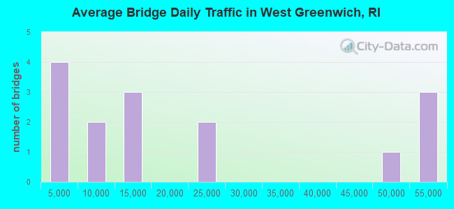
- 309,611Total average daily traffic
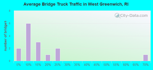
- 39,014Total average daily truck traffic
- National Bridge Inventory (NBI) Registered Bridges for West Greenwich
- No street view available for this location
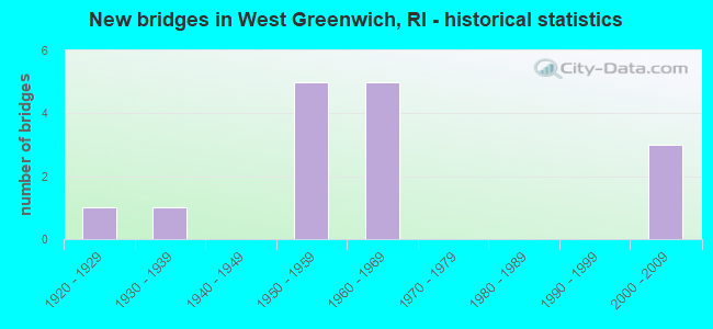
- New bridges - historical statistics
- 11920-1929
- 11930-1939
- 51950-1959
- 51960-1969
- 32000-2009
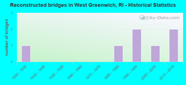
- Reconstructed bridges - Historical Statistics
- 11930-1939
- 01940-1949
- 01950-1959
- 01960-1969
- 01970-1979
- 11980-1989
- 21990-1999
- 12000-2009
- 22010-2019
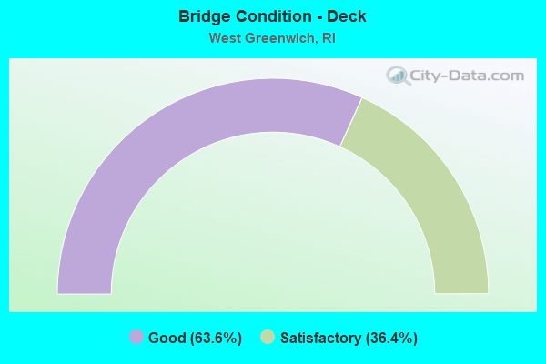
- Bridge Condition - Deck
- 63.6%Good
- 36.4%Satisfactory
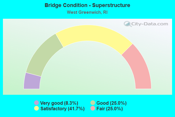
- Bridge Condition - Superstructure
- 8.3%Very good
- 25.0%Good
- 41.7%Satisfactory
- 25.0%Fair
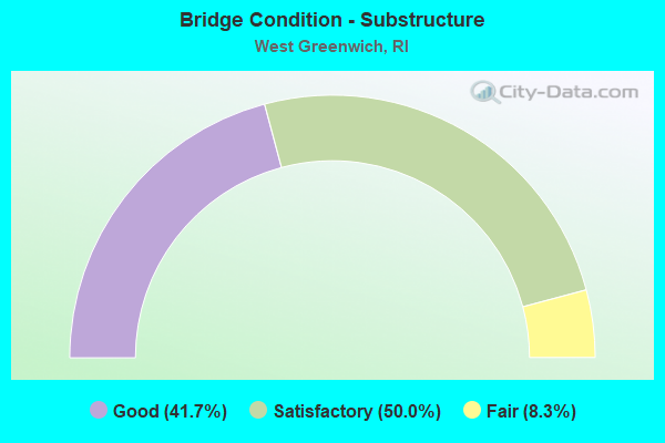
- Bridge Condition - Substructure
- 41.7%Good
- 50.0%Satisfactory
- 8.3%Fair
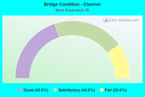
- Bridge Condition - Channel
- 40.0%Good
- 40.0%Satisfactory
- 20.0%Fair
Find on map >> Show street view
Structure Number: 36, Location: 2.3 Mi S of JCT I-95 (Lat: 41.626708, Lng: -71.632653), Route carried "on" structure: State highway 3, Year Built: 1924, Year Reconstructed: 1939, Status: Open, Structure Length: 0.64m (2.10ft), Average Daily Traffic: 4,944 (year 2021), Truck Traffic: 8%, Average Future Daily Traffic: 5,438 (year 2041), Design Load: HS 20, Features Intersected: NOOSENECK RIVER
Minimum Vertical Clearance: 30+ m (98+ ft), Kilometerpoint: 34.569, Lanes on structure: 4, Owner: State Highway Agency, Approaching Roadway Width: 19.2m (63.0ft), Material/Design: Concrete, Design/Construction: Arch - Deck, Number Of Spans In Main Unit: 1, Length of Maximum Span: 6.4m (21.0ft), Curb or Sidewalk Widths: Left: 2.0m (6.6ft), Right: 2.0m (6.6ft), Curb-To-Curb Width: 19.2m (63.0ft), Out-to-Out Width: 24.3m (79.7ft)
Condition: Superstructure: Fair, Substructure: Fair, Channel: Fair, Operating Rating: 48.3 metric tons, Method Used To Determine Operating Rating: Load and Resistance Factor Rating (LRFR) rating reported by rating factor(RF) method using HL-93 loadings, Inventory Rating: 36.3 metric tons, Method Used To Determine Inventory Rating: Load and Resistance Factor Rating (LRFR) rating reported by rating factor(RF) method using HL-93 loadings, Structural Evaluation: Somewhat better than minimum adequacy, Deck Geometry: Equal to present minimum criteria, Waterway Adequacy: Equal to present desirable criteria, Approach Roadway Alignment: Better than present minimum criteria, Length Of Structure Improvement: 0.64m (2.10ft), Designated Inspection Frequency: Every 24 months, Inspection Date: April 2021, Bridge Improvement Cost: $323,000, Roadway Improvement Cost: $32,000, Total Project Cost: $484,000
Find on map >> Show street view
Structure Number: 52, Location: 0.5 Mi W of JCT RI 3 (Lat: 41.413797, Lng: -71.797217), Route carried "on" structure: City street , Year Built: 2002, Status: Open, Structure Length: 3.67m (12.04ft), Average Daily Traffic: 759 (year 2021), Truck Traffic: 6%, Average Future Daily Traffic: 835 (year 2041), Design Load: HS 25 or greater, Features Intersected: PAWCATUCK RIVER, Facility Carried by Structure: POTTER HILL RD
Minimum Vertical Clearance: 5.49m (18.01ft), Kilometerpoint: 4.118, Lanes on structure: 2, Owner: State Highway Agency, Approaching Roadway Width: 7.9m (25.9ft), Material/Design: Prestressed concrete, Design/Construction: Box Beam or Girders - Multiple, Number Of Spans In Main Unit: 2, Length of Maximum Span: 17.7m (58.1ft), Curb or Sidewalk Widths: Left: 1.6m (5.2ft), Right: 0.2m (0.7ft), Curb-To-Curb Width: 7.9m (25.9ft), Out-to-Out Width: 10.8m (35.4ft)
Condition: Deck: Good, Superstructure: Satisfactory, Substructure: Satisfactory, Channel: Good, Operating Rating: 83.3 metric tons, Method Used To Determine Operating Rating: Load and Resistance Factor Rating (LRFR) rating reported by rating factor(RF) method using HL-93 loadings, Inventory Rating: 64.2 metric tons, Method Used To Determine Inventory Rating: Load and Resistance Factor Rating (LRFR) rating reported by rating factor(RF) method using HL-93 loadings, Structural Evaluation: Equal to present minimum criteria, Deck Geometry: Somewhat better than minimum adequacy, Waterway Adequacy: Better than present minimum criteria, Approach Roadway Alignment: Somewhat better than minimum adequacy, Length Of Structure Improvement: 3.67m (12.04ft), Designated Inspection Frequency: Every 24 months, Underwater Inspection Frequency: Every 48 months, Inspection Date: October 2021, Underwater Inspection Date: May 2020, Bridge Improvement Cost: $833,000, Roadway Improvement Cost: $83,000, Total Project Cost: $1,249,000, Deck Structure Type: Concrete Cast-file-Place, Wearing Surface/Protective System: Wearing Surface: Bituminous, Membrane: Other
Find on map >> Show street view
Structure Number: 118, Location: URI Alton Jones Campus (Lat: 41.616869, Lng: -71.719486), Route carried "on" structure: State lands road , Year Built: 1931, Year Reconstructed: 1990, Status: Posted for load, Structure Length: 0.99m (3.25ft), Average Daily Traffic: 9 (year 2021), Truck Traffic: 67%, Average Future Daily Traffic: 10 (year 2041), Design Load: HS 20, Features Intersected: EISENHOWER LAKE, Facility Carried by Structure: WHISPER PINE RD
Minimum Vertical Clearance: 30+ m (98+ ft), Kilometerpoint: 0.340, Lanes on structure: 1, Owner: State Highway Agency, Approaching Roadway Width: 3.7m (12.1ft), Material/Design: Prestressed concrete, Design/Construction: Slab, Number Of Spans In Main Unit: 1, Length of Maximum Span: 9.4m (30.8ft), Curb-To-Curb Width: 3.8m (12.5ft), Out-to-Out Width: 4.3m (14.1ft)
Condition: Deck: Good, Superstructure: Fair, Substructure: Good, Channel: Satisfactory, Operating Rating: 25.3 metric tons, Method Used To Determine Operating Rating: Load and Resistance Factor Rating (LRFR) rating reported by rating factor(RF) method using HL-93 loadings, Inventory Rating: 19.4 metric tons, Method Used To Determine Inventory Rating: Load and Resistance Factor Rating (LRFR) rating reported by rating factor(RF) method using HL-93 loadings, Structural Evaluation: Somewhat better than minimum adequacy, Deck Geometry: Meets minimum limits, Waterway Adequacy: Superior to present desirable criteria, Approach Roadway Alignment: Equal to present desirable criteria, Bridge Posting: Required (Relationship of Operating Rating to Maximum Legal Load: 0.1 - 9.9% below), Length Of Structure Improvement: 0.98m (3.22ft), Designated Inspection Frequency: Every 24 months, Other Special Inspection Frequency: Every 12 months, Inspection Date: March 2020, Other Special Inspection Date: March 2021, Bridge Improvement Cost: $27,000, Roadway Improvement Cost: $3,000, Total Project Cost: $41,000, Deck Structure Type: Concrete Precast Panels, Wearing Surface/Protective System: Wearing Surface: Bituminous, Membrane: Preformed Fabric
Find on map >> Show street view
Structure Number: 517, Location: 1.3 Mi S of NEW LONDON TP (Lat: 41.652717, Lng: -71.575333), Route carried "on" structure: Interstate 95, Year Built: 1958, Status: Open, Structure Length: 1.58m (5.18ft), Average Daily Traffic: 53,440 (year 2021), Truck Traffic: 12%, Average Future Daily Traffic: 58,784 (year 2041), Design Load: HS 20, Features Intersected: HOPKINS HILL RD
Minimum Vertical Clearance: 6.71m (22.01ft), Kilometerpoint: 32.048, Lanes on structure: 5, Lanes under structure: 3, Base Highway Network: Yes, Owner: State Highway Agency, Approaching Roadway Width: 30.5m (100.1ft), Skew: 20 degrees, Material/Design: Concrete, Design/Construction: Frame, Number Of Spans In Main Unit: 1, Length of Maximum Span: 13.4m (44.0ft), Curb-To-Curb Width: 31.1m (102.0ft), Out-to-Out Width: 32.3m (106.0ft)
Condition: Deck: Satisfactory, Superstructure: Satisfactory, Substructure: Satisfactory, Operating Rating: 76.5 metric tons, Method Used To Determine Operating Rating: Load and Resistance Factor Rating (LRFR) rating reported by rating factor(RF) method using HL-93 loadings, Inventory Rating: 59.0 metric tons, Method Used To Determine Inventory Rating: Load and Resistance Factor Rating (LRFR) rating reported by rating factor(RF) method using HL-93 loadings, Structural Evaluation: Equal to present minimum criteria, Deck Geometry: Superior to present desirable criteria, Underclear: High priority of corrective action, Approach Roadway Alignment: Equal to present desirable criteria, Length Of Structure Improvement: 1.59m (5.22ft), Designated Inspection Frequency: Every 24 months, Inspection Date: April 2020, Bridge Improvement Cost: $1,078,000, Roadway Improvement Cost: $108,000, Total Project Cost: $1,616,000, Deck Structure Type: Concrete Cast-file-Place, Wearing Surface/Protective System: Wearing Surface: Bituminous, Membrane: Preformed Fabric
Find on map >> Show street view
Structure Number: 519, Location: 2.0 Mi E of JCT RI 3 (Lat: 41.659336, Lng: -71.547944), Route carried "on" structure: Alternate State highway , Year Built: 1957, Year Reconstructed: 1998, Status: Open, Structure Length: 8.20m (26.90ft), Average Daily Traffic: 11,087 (year 2021), Truck Traffic: 10%, Average Future Daily Traffic: 12,196 (year 2041), Design Load: HS 20, Features Intersected: I-95 NB & SB, Facility Carried by Structure: NEW LONDON TRNPK
Minimum Vertical Clearance: 30+ m (98+ ft), Kilometerpoint: 0.845, Lanes on structure: 2, Lanes under structure: 4, Owner: State Highway Agency, Approaching Roadway Width: 13.4m (44.0ft), Skew: 24 degrees, Material/Design: Steel continuous, Design/Construction: Stringer/Multi-beam, Number Of Spans In Main Unit: 4, Length of Maximum Span: 24.7m (81.0ft), Curb-To-Curb Width: 13.4m (44.0ft), Out-to-Out Width: 14.4m (47.2ft)
Condition: Deck: Satisfactory, Superstructure: Satisfactory, Substructure: Satisfactory, Operating Rating: 52.8 metric tons, Method Used To Determine Operating Rating: Load and Resistance Factor Rating (LRFR) rating reported by rating factor(RF) method using HL-93 loadings, Inventory Rating: 40.8 metric tons, Method Used To Determine Inventory Rating: Load and Resistance Factor Rating (LRFR) rating reported by rating factor(RF) method using HL-93 loadings, Structural Evaluation: Equal to present minimum criteria, Deck Geometry: Equal to present minimum criteria, Underclear: Equal to present minimum criteria, Approach Roadway Alignment: Better than present minimum criteria, Length Of Structure Improvement: 8.20m (26.90ft), Designated Inspection Frequency: Every 24 months, Inspection Date: November 2021, Bridge Improvement Cost: $2,501,000, Roadway Improvement Cost: $250,000, Total Project Cost: $3,752,000, Deck Structure Type: Concrete Cast-file-Place, Wearing Surface/Protective System: Wearing Surface: Monolithic Concrete, Deck Protection: Epoxy Coated Reinforcing
Find on map >> Show street view
Structure Number: 52, Location: 0.7 Mi N DIVISION ST. (Lat: 41.650967, Lng: -71.605997), Route carried "on" structure: State highway 3, Year Built: 1957, Year Reconstructed: 2006, Status: Open, Structure Length: 3.51m (11.52ft), Average Daily Traffic: 12,310 (year 2021), Truck Traffic: 4%, Average Future Daily Traffic: 13,541 (year 2041), Design Load: HS 25 or greater, Features Intersected: I-95 NB & SB
Minimum Vertical Clearance: 30+ m (98+ ft), Kilometerpoint: 38.257, Lanes on structure: 4, Lanes under structure: 4, Base Highway Network: Yes, Owner: State Highway Agency, Approaching Roadway Width: 20.7m (67.9ft), Material/Design: Steel continuous, Design/Construction: Stringer/Multi-beam, Number Of Spans In Main Unit: 2, Length of Maximum Span: 17.1m (56.1ft), Curb or Sidewalk Widths: Left: 0.1m (0.3ft), Right: 0.1m (0.3ft), Curb-To-Curb Width: 20.7m (67.9ft), Out-to-Out Width: 21.9m (71.9ft)
Condition: Deck: Good, Superstructure: Good, Substructure: Good, Operating Rating: 52.5 metric tons, Method Used To Determine Operating Rating: Load and Resistance Factor Rating (LRFR) rating reported by rating factor(RF) method using HL-93 loadings, Inventory Rating: 40.5 metric tons, Method Used To Determine Inventory Rating: Load and Resistance Factor Rating (LRFR) rating reported by rating factor(RF) method using HL-93 loadings, Structural Evaluation: Better than present minimum criteria, Deck Geometry: Superior to present desirable criteria, Underclear: Somewhat better than minimum adequacy, Approach Roadway Alignment: Better than present minimum criteria, Length Of Structure Improvement: 3.41m (11.19ft), Designated Inspection Frequency: Every 24 months, Inspection Date: December 2021, Bridge Improvement Cost: $2,241,000, Roadway Improvement Cost: $224,000, Total Project Cost: $3,362,000, Deck Structure Type: Concrete Cast-file-Place, Wearing Surface/Protective System: Wearing Surface: Monolithic Concrete, Deck Protection: Epoxy Coated Reinforcing
Find on map >> Show street view
Structure Number: 521, Location: 0.7 Mi S of JCT RI 3 (Lat: 41.648858, Lng: -71.613653), Route carried "on" structure: Interstate 95, Year Built: 1960, Status: Open, Structure Length: 1.28m (4.20ft), Average Daily Traffic: 49,641 (year 2015), Truck Traffic: 7%, Average Future Daily Traffic: 59,570 (year 2036), Design Load: HS 20, Features Intersected: BIG RIVER
Minimum Vertical Clearance: 30+ m (98+ ft), Kilometerpoint: 28.711, Lanes on structure: 4, Base Highway Network: Yes, Owner: State Highway Agency, Approaching Roadway Width: 23.2m (76.1ft), Skew: 32 degrees, Material/Design: Concrete, Design/Construction: Culvert, Number Of Spans In Main Unit: 3, Length of Maximum Span: 4.0m (13.1ft), Out-to-Out Width: 23.2m (76.1ft)
Condition: Channel: Good, Culverts: Satisfactory, Operating Rating: 97.2 metric tons, Method Used To Determine Operating Rating: Load and Resistance Factor Rating (LRFR) rating reported by rating factor(RF) method using HL-93 loadings, Inventory Rating: 97.2 metric tons, Method Used To Determine Inventory Rating: Load and Resistance Factor Rating (LRFR) rating reported by rating factor(RF) method using HL-93 loadings, Structural Evaluation: Equal to present minimum criteria, Waterway Adequacy: Superior to present desirable criteria, Approach Roadway Alignment: Equal to present desirable criteria, Length Of Structure Improvement: 1.40m (4.59ft), Designated Inspection Frequency: Every 24 months, Underwater Inspection Frequency: Every 48 months, Inspection Date: May 2020, Underwater Inspection Date: May 2020, Bridge Improvement Cost: $197,000, Roadway Improvement Cost: $20,000, Total Project Cost: $295,000
Find on map >> Show street view
Structure Number: 586, Location: 1.0 Mi S of JCT RI 3 (Lat: 41.639792, Lng: -71.624953), Route carried "on" structure: Interstate 95, Year Built: 1968, Year Reconstructed: 2010, Status: Open, Structure Length: 2.74m (8.99ft), Average Daily Traffic: 50,500 (year 2021), Truck Traffic: 21%, Average Future Daily Traffic: 55,550 (year 2041), Design Load: HS 20, Features Intersected: WEAVER HILL RD
Minimum Vertical Clearance: 30+ m (98+ ft), Kilometerpoint: 27.331, Lanes on structure: 2, Lanes under structure: 2, Base Highway Network: Yes, Owner: State Highway Agency, Approaching Roadway Width: 13.7m (44.9ft), Material/Design: Steel, Design/Construction: Stringer/Multi-beam, Number Of Spans In Main Unit: 1, Length of Maximum Span: 26.2m (86.0ft), Curb-To-Curb Width: 13.7m (44.9ft), Out-to-Out Width: 14.8m (48.6ft)
Condition: Deck: Satisfactory, Superstructure: Satisfactory, Substructure: Satisfactory, Operating Rating: 72.9 metric tons, Method Used To Determine Operating Rating: Load and Resistance Factor Rating (LRFR) rating reported by rating factor(RF) method using HL-93 loadings, Inventory Rating: 56.1 metric tons, Method Used To Determine Inventory Rating: Load and Resistance Factor Rating (LRFR) rating reported by rating factor(RF) method using HL-93 loadings, Structural Evaluation: Equal to present minimum criteria, Deck Geometry: Superior to present desirable criteria, Underclear: Equal to present minimum criteria, Approach Roadway Alignment: Equal to present desirable criteria, Length Of Structure Improvement: 2.71m (8.89ft), Designated Inspection Frequency: Every 24 months, Inspection Date: July 2021, Bridge Improvement Cost: $739,000, Roadway Improvement Cost: $74,000, Total Project Cost: $1,108,000, Deck Structure Type: Concrete Cast-file-Place, Wearing Surface/Protective System: Wearing Surface: Monolithic Concrete
Find on map >> Show street view
Structure Number: 5862, Location: 1.0 Mi S of JCT RI 3 (Lat: 41.639947, Lng: -71.625364), Route carried "on" structure: Interstate 95, Year Built: 1968, Year Reconstructed: 2010, Status: Open, Structure Length: 2.71m (8.89ft), Average Daily Traffic: 50,500 (year 2021), Truck Traffic: 21%, Average Future Daily Traffic: 55,550 (year 2041), Design Load: HS 20, Features Intersected: WEAVER HILL RD
Minimum Vertical Clearance: 30+ m (98+ ft), Kilometerpoint: 42.324, Lanes on structure: 2, Lanes under structure: 2, Base Highway Network: Yes, Owner: State Highway Agency, Approaching Roadway Width: 13.1m (43.0ft), Material/Design: Steel, Design/Construction: Stringer/Multi-beam, Number Of Spans In Main Unit: 1, Length of Maximum Span: 26.2m (86.0ft), Curb-To-Curb Width: 13.1m (43.0ft), Out-to-Out Width: 13.1m (43.0ft)
Condition: Deck: Satisfactory, Superstructure: Satisfactory, Substructure: Satisfactory, Operating Rating: 72.6 metric tons, Method Used To Determine Operating Rating: Load and Resistance Factor Rating (LRFR) rating reported by rating factor(RF) method using HL-93 loadings, Inventory Rating: 55.7 metric tons, Method Used To Determine Inventory Rating: Load and Resistance Factor Rating (LRFR) rating reported by rating factor(RF) method using HL-93 loadings, Structural Evaluation: Equal to present minimum criteria, Deck Geometry: Superior to present desirable criteria, Underclear: Somewhat better than minimum adequacy, Approach Roadway Alignment: Equal to present desirable criteria, Length Of Structure Improvement: 2.71m (8.89ft), Designated Inspection Frequency: Every 24 months, Inspection Date: July 2021, Bridge Improvement Cost: $185,000, Roadway Improvement Cost: $19,000, Total Project Cost: $278,000, Deck Structure Type: Concrete Cast-file-Place, Wearing Surface/Protective System: Wearing Surface: Monolithic Concrete, Deck Protection: Epoxy Coated Reinforcing
Find on map >> Show street view
Structure Number: 588, Location: 1.3 Mi N of JCT RI 102 (Lat: 41.619231, Lng: -71.645358), Route carried "on" structure: Interstate 95, Year Built: 2007, Status: Open, Structure Length: 2.12m (6.96ft), Average Daily Traffic: 24,820 (year 2015), Truck Traffic: 7%, Average Future Daily Traffic: 29,784 (year 2036), Design Load: HS 25 or greater, Features Intersected: ROBIN HOLLOW RD
Minimum Vertical Clearance: 30+ m (98+ ft), Kilometerpoint: 24.473, Lanes on structure: 2, Lanes under structure: 2, Base Highway Network: Yes, Owner: State Highway Agency, Approaching Roadway Width: 13.7m (44.9ft), Skew: 1 degrees, Material/Design: Prestressed concrete, Design/Construction: Stringer/Multi-beam, Number Of Spans In Main Unit: 1, Length of Maximum Span: 19.9m (65.3ft), Curb-To-Curb Width: 13.7m (44.9ft), Out-to-Out Width: 14.8m (48.6ft)
Condition: Deck: Good, Superstructure: Good, Substructure: Good, Operating Rating: 60.9 metric tons, Method Used To Determine Operating Rating: Load and Resistance Factor Rating (LRFR) rating reported by rating factor(RF) method using HL-93 loadings, Inventory Rating: 47.0 metric tons, Method Used To Determine Inventory Rating: Load and Resistance Factor Rating (LRFR) rating reported by rating factor(RF) method using HL-93 loadings, Structural Evaluation: Better than present minimum criteria, Deck Geometry: Superior to present desirable criteria, Underclear: Meets minimum limits, Approach Roadway Alignment: Equal to present desirable criteria, Length Of Structure Improvement: 2.68m (8.79ft), Designated Inspection Frequency: Every 24 months, Inspection Date: December 2021, Bridge Improvement Cost: $1,288,000, Roadway Improvement Cost: $129,000, Total Project Cost: $1,932,000, Deck Structure Type: Concrete Cast-file-Place, Wearing Surface/Protective System: Wearing Surface: Monolithic Concrete, Deck Protection: Epoxy Coated Reinforcing
Find on map >> Show street view
Structure Number: 5882, Location: 1.3 Mi N of JCT RI 102 (Lat: 41.619442, Lng: -71.645992), Route carried "on" structure: Interstate 95, Year Built: 2007, Status: Open, Structure Length: 2.12m (6.96ft), Average Daily Traffic: 24,820 (year 2008), Truck Traffic: 10%, Average Future Daily Traffic: 29,784 (year 2036), Design Load: HS 20, Features Intersected: ROBIN HOLLOW RD
Minimum Vertical Clearance: 30+ m (98+ ft), Kilometerpoint: 45.194, Lanes on structure: 2, Lanes under structure: 2, Base Highway Network: Yes, Owner: State Highway Agency, Approaching Roadway Width: 13.7m (44.9ft), Skew: 1 degrees, Material/Design: Prestressed concrete, Design/Construction: Stringer/Multi-beam, Number Of Spans In Main Unit: 1, Length of Maximum Span: 19.8m (65.0ft), Curb-To-Curb Width: 13.7m (44.9ft), Out-to-Out Width: 14.8m (48.6ft)
Condition: Deck: Good, Superstructure: Good, Substructure: Good, Operating Rating: 60.3 metric tons, Method Used To Determine Operating Rating: Load and Resistance Factor Rating (LRFR) rating reported by rating factor(RF) method using HL-93 loadings, Inventory Rating: 34.0 metric tons, Method Used To Determine Inventory Rating: Load and Resistance Factor Rating (LRFR) rating reported by rating factor(RF) method using HL-93 loadings, Structural Evaluation: Better than present minimum criteria, Deck Geometry: Superior to present desirable criteria, Underclear: Meets minimum limits, Approach Roadway Alignment: Equal to present desirable criteria, Length Of Structure Improvement: 2.01m (6.59ft), Designated Inspection Frequency: Every 24 months, Inspection Date: December 2021, Bridge Improvement Cost: $197,000, Roadway Improvement Cost: $20,000, Total Project Cost: $296,000, Deck Structure Type: Concrete Cast-file-Place, Wearing Surface/Protective System: Wearing Surface: Monolithic Concrete, Membrane: Epoxy
Find on map >> Show street view
Structure Number: 5895, Location: 0.8 Mi S of JCT RI165 (Lat: 41.603219, Lng: -71.657419), Route carried "on" structure: State highway 102, Year Built: 1969, Status: Open, Structure Length: 9.67m (31.73ft), Average Daily Traffic: 7,203 (year 2021), Truck Traffic: 8%, Average Future Daily Traffic: 7,923 (year 2041), Design Load: HL 93, Features Intersected: I-95 NB and SB
Minimum Vertical Clearance: 30+ m (98+ ft), Kilometerpoint: 19.484, Lanes on structure: 2, Lanes under structure: 6, Base Highway Network: Yes, Owner: State Highway Agency, Approaching Roadway Width: 19.1m (62.7ft), Skew: 33 degrees, Material/Design: Steel continuous, Design/Construction: Stringer/Multi-beam, Number Of Spans In Main Unit: 3, Length of Maximum Span: 31.7m (104.0ft), Curb or Sidewalk Widths: Left: 0.5m (1.6ft), Right: 0.5m (1.6ft), Curb-To-Curb Width: 19.1m (62.7ft), Out-to-Out Width: 21.3m (69.9ft)
Condition: Deck: Good, Superstructure: Very good, Substructure: Good, Operating Rating: 68.0 metric tons, Method Used To Determine Operating Rating: Load and Resistance Factor Rating (LRFR) rating reported by rating factor(RF) method using HL-93 loadings, Inventory Rating: 52.5 metric tons, Method Used To Determine Inventory Rating: Load and Resistance Factor Rating (LRFR) rating reported by rating factor(RF) method using HL-93 loadings, Structural Evaluation: Better than present minimum criteria, Deck Geometry: Superior to present desirable criteria, Underclear: High priority of corrective action, Approach Roadway Alignment: Equal to present desirable criteria, Length Of Structure Improvement: 9.60m (31.50ft), Designated Inspection Frequency: Every 24 months, Inspection Date: November 2021, Bridge Improvement Cost: $6,695,000, Roadway Improvement Cost: $669,000, Total Project Cost: $10,043,000, Deck Structure Type: Concrete Cast-file-Place, Wearing Surface/Protective System: Wearing Surface: Bituminous, Membrane: Built-up, Deck Protection: Galvanized Reinforcing
Find on map >> Show street view
Structure Number: 1216, Location: 0.11Mi SofJct Muddy Br RD (Lat: 41.635389, Lng: -71.766017), Route carried "on" structure: City street , Year Built: 1950, Year Reconstructed: 1980, Status: Posted for load, Structure Length: 0.67m (2.20ft), Average Daily Traffic: 65 (year 2021), Truck Traffic: 15%, Average Future Daily Traffic: 72 (year 2041), Features Intersected: Kelley Brook, Facility Carried by Structure: HUDSON POND ROAD
Minimum Vertical Clearance: 30+ m (98+ ft), Kilometerpoint: 0.193, Lanes on structure: 2, Owner: Town or Township Highway Agency, Approaching Roadway Width: 7.3m (24.0ft), Material/Design: Wood or Timber, Design/Construction: Slab, Number Of Spans In Main Unit: 1, Length of Maximum Span: 6.7m (22.0ft), Curb-To-Curb Width: 7.3m (24.0ft), Out-to-Out Width: 7.6m (24.9ft)
Condition: Deck: Good, Superstructure: Fair, Substructure: Satisfactory, Channel: Satisfactory, Operating Rating: 35.3 metric tons, Method Used To Determine Operating Rating: Load and Resistance Factor Rating (LRFR) rating reported by rating factor(RF) method using HL-93 loadings, Inventory Rating: 26.2 metric tons, Method Used To Determine Inventory Rating: Load and Resistance Factor Rating (LRFR) rating reported by rating factor(RF) method using HL-93 loadings, Structural Evaluation: Somewhat better than minimum adequacy, Deck Geometry: Equal to present minimum criteria, Waterway Adequacy: Equal to present desirable criteria, Approach Roadway Alignment: Equal to present desirable criteria, Bridge Posting: Required (Relationship of Operating Rating to Maximum Legal Load: > 39.9% below), Designated Inspection Frequency: Every 24 months, Other Special Inspection Frequency: Every 12 months, Inspection Date: June 2021, Other Special Inspection Date: June 2021, Deck Structure Type: Wood or Timber, Wearing Surface/Protective System: Wearing Surface: Bituminous
Find on map >> Show street view
Structure Number: 52, Location: 0.7 Mi N DIVISION ST. (Lat: 41.650967, Lng: -71.605997), Route carried "under" structure: Interstate 95, Year Built: 1957, Structure Length: 0. m, Average Daily Traffic: 12,310 (year 2021), Truck Traffic: 4%, Features Intersected: I-95 NB & SB, Facility Carried by Structure: RI 3 NSNCK HILL RD
Minimum Vertical Clearance: 4.26m (13.98ft), Kilometerpoint: 0.000, Lanes on structure: 4, Lanes under structure: 4, Material/Design: Steel continuous, Design/Construction: Stringer/Multi-beam, Length of Maximum Span: 17.1m (56.1ft)
Find on map >> Show street view
Structure Number: 5895, Location: 0.8 Mi S of JCT RI165 (Lat: 41.603219, Lng: -71.657419), Route carried "under" structure: Interstate 95, Year Built: 1969, Structure Length: 0. m, Average Daily Traffic: 7,203 (year 2021), Truck Traffic: 8%, Features Intersected: I-95 NB and SB, Facility Carried by Structure: RI 102 VICTORY HWY
Minimum Vertical Clearance: 5.39m (17.68ft), Kilometerpoint: 0.000, Lanes on structure: 2, Lanes under structure: 6, Material/Design: Steel continuous, Design/Construction: Stringer/Multi-beam, Length of Maximum Span: 31.7m (104.0ft)