Bridge Statistics for West End, New York (NY)
Condition, Traffic, Stress, Structural Evaluation, Project Costs
- National Bridge Inventory (NBI) Statistics
- 21Number of bridges
- 220ft / 66.7mTotal length
- $34,369,000Total costs
- 82,331Total average daily traffic
- 11,315Total average daily truck traffic
- National Bridge Inventory (NBI) Registered Bridges for West End
- No street view available for this location
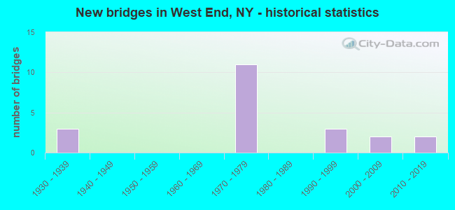
- New bridges - historical statistics
- 31930-1939
- 111970-1979
- 31990-1999
- 22000-2009
- 22010-2019
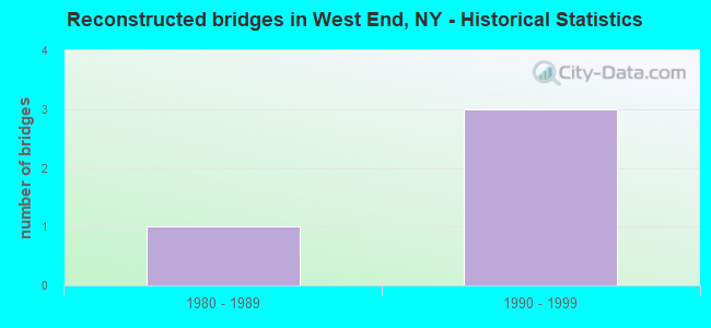
- Reconstructed bridges - Historical Statistics
- 11980-1989
- 31990-1999
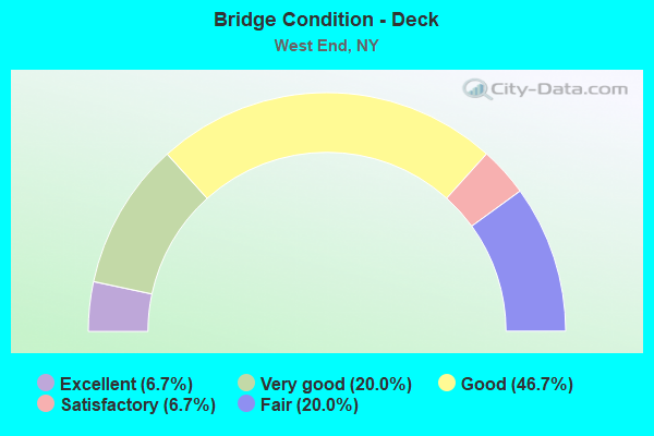
- Bridge Condition - Deck
- 6.7%Excellent
- 20.0%Very good
- 46.7%Good
- 6.7%Satisfactory
- 20.0%Fair
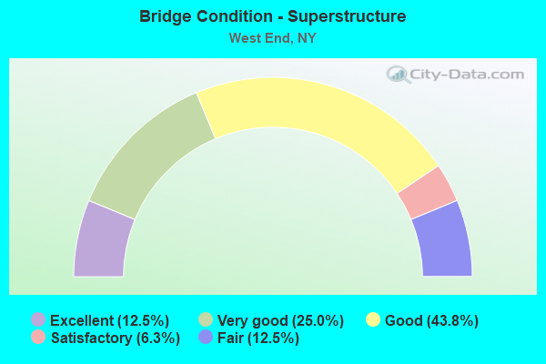
- Bridge Condition - Superstructure
- 12.5%Excellent
- 25.0%Very good
- 43.8%Good
- 6.3%Satisfactory
- 12.5%Fair
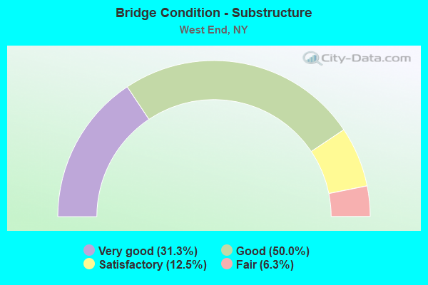
- Bridge Condition - Substructure
- 31.3%Very good
- 50.0%Good
- 12.5%Satisfactory
- 6.3%Fair
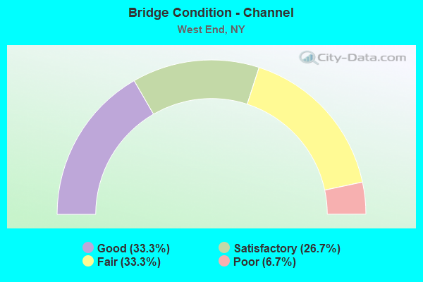
- Bridge Condition - Channel
- 33.3%Good
- 26.7%Satisfactory
- 33.3%Fair
- 6.7%Poor
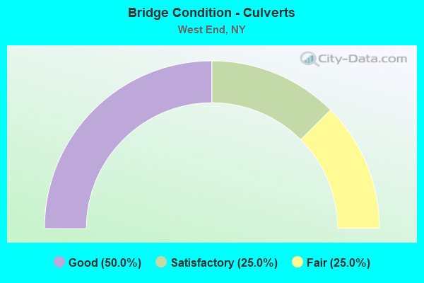
- Bridge Condition - Culverts
- 50.0%Good
- 25.0%Satisfactory
- 25.0%Fair
Find on map >> Show street view
Structure Number: 100396, Location: 3.3 MI SW JCT RTS 7 + 23 (Lat: 42.422389, Lng: -75.141178), Route carried "on" structure: State highway 7, Year Built: 1931, Status: Open, Structure Length: 0.79m (2.59ft), Average Daily Traffic: 2,689 (year 2019), Truck Traffic: 4%, Average Future Daily Traffic: 3,327 (year 2040), Features Intersected: MILL CREEK
Minimum Vertical Clearance: 30+ m (98+ ft), Kilometerpoint: 29.396, Lanes on structure: 2, Base Highway Network: Yes, Owner: State Highway Agency, Approaching Roadway Width: 9.8m (32.2ft), Skew: 1 degrees, Material/Design: Concrete, Design/Construction: Slab, Number Of Spans In Main Unit: 1, Length of Maximum Span: 7.3m (24.0ft), Curb-To-Curb Width: 10.2m (33.5ft), Out-to-Out Width: 11.1m (36.4ft)
Condition: Deck: Fair, Superstructure: Fair, Substructure: Satisfactory, Channel: Fair, Operating Rating: 66.2 metric tons, Method Used To Determine Operating Rating: Load Factor (LF), Inventory Rating: 39.9 metric tons, Method Used To Determine Inventory Rating: Load Factor (LF), Structural Evaluation: Somewhat better than minimum adequacy, Deck Geometry: Meets minimum limits, Waterway Adequacy: Meets minimum limits, Approach Roadway Alignment: Equal to present desirable criteria, Length Of Structure Improvement: 0.79m (2.59ft), Designated Inspection Frequency: Every 24 months, Inspection Date: April 2021, Bridge Improvement Cost: $358,000, Roadway Improvement Cost: $210,000, Total Project Cost: $567,000 ( Estimate for 2021), Wearing Surface/Protective System: Wearing Surface: Bituminous
Find on map >> Show street view
Structure Number: 100397, Location: 1.9 MI SW JCT SH 7 & SH 2 (Lat: 42.435872, Lng: -75.120578), Route carried "on" structure: State highway 7, Year Built: 1994, Status: Open, Structure Length: 4.63m (15.19ft), Average Daily Traffic: 3,121 (year 2020), Truck Traffic: 6%, Average Future Daily Traffic: 3,791 (year 2040), Design Load: HS 25 or greater, Features Intersected: OTEGO CREEK
Minimum Vertical Clearance: 30+ m (98+ ft), Kilometerpoint: 31.697, Lanes on structure: 2, Base Highway Network: Yes, Owner: State Highway Agency, Approaching Roadway Width: 9.7m (31.8ft), Skew: 3 degrees, Material/Design: Steel, Design/Construction: Stringer/Multi-beam, Number Of Spans In Main Unit: 1, Length of Maximum Span: 44.8m (147.0ft), Curb-To-Curb Width: 9.8m (32.2ft), Out-to-Out Width: 10.4m (34.1ft)
Condition: Deck: Good, Superstructure: Good, Substructure: Very good, Channel: Satisfactory, Operating Rating: 88.9 metric tons, Method Used To Determine Operating Rating: Load Factor (LF), Inventory Rating: 44.5 metric tons, Method Used To Determine Inventory Rating: Load Factor (LF), Structural Evaluation: Better than present minimum criteria, Deck Geometry: Meets minimum limits, Waterway Adequacy: Equal to present desirable criteria, Approach Roadway Alignment: Equal to present desirable criteria, Length Of Structure Improvement: 4.63m (15.19ft), Designated Inspection Frequency: Every 24 months, Inspection Date: March 2020, Bridge Improvement Cost: $1,195,000, Roadway Improvement Cost: $700,000, Total Project Cost: $1,895,000 ( Estimate for 2021), Deck Structure Type: Concrete Cast-file-Place, Wearing Surface/Protective System: Wearing Surface: Integral Concrete, Deck Protection: Epoxy Coated Reinforcing
Find on map >> Show street view
Structure Number: 101756, Location: 3.4 MI N WEST ONEONTA (Lat: 42.516047, Lng: -75.138231), Route carried "on" structure: State highway 23, Year Built: 1936, Status: Open, Structure Length: 0.76m (2.49ft), Average Daily Traffic: 3,913 (year 2018), Truck Traffic: 8%, Average Future Daily Traffic: 3,950 (year 2040), Features Intersected: HARRISON CREEK
Minimum Vertical Clearance: 30+ m (98+ ft), Kilometerpoint: 23.636, Lanes on structure: 2, Base Highway Network: Yes, Owner: State Highway Agency, Approaching Roadway Width: 10.4m (34.1ft), Skew: 3 degrees, Material/Design: Concrete, Design/Construction: Slab, Number Of Spans In Main Unit: 1, Length of Maximum Span: 7.3m (24.0ft), Curb-To-Curb Width: 10.5m (34.4ft), Out-to-Out Width: 11.2m (36.7ft)
Condition: Deck: Satisfactory, Superstructure: Fair, Substructure: Fair, Channel: Fair, Operating Rating: 57.2 metric tons, Method Used To Determine Operating Rating: Load Factor (LF), Inventory Rating: 34.5 metric tons, Method Used To Determine Inventory Rating: Load Factor (LF), Structural Evaluation: Somewhat better than minimum adequacy, Deck Geometry: Somewhat better than minimum adequacy, Waterway Adequacy: High priority of corrective action, Approach Roadway Alignment: Equal to present desirable criteria, Length Of Structure Improvement: 0.76m (2.49ft), Designated Inspection Frequency: Every 24 months, Inspection Date: July 2020, Bridge Improvement Cost: $438,000, Roadway Improvement Cost: $256,000, Total Project Cost: $694,000 ( Estimate for 2021), Wearing Surface/Protective System: Wearing Surface: Bituminous
Find on map >> Show street view
Structure Number: 101757, Location: 2.9 MI N WEST ONEONTA (Lat: 42.509964, Lng: -75.135494), Route carried "on" structure: State highway 23, Year Built: 1936, Year Reconstructed: 1980, Status: Open, Structure Length: 1.62m (5.31ft), Average Daily Traffic: 3,913 (year 2018), Truck Traffic: 8%, Average Future Daily Traffic: 3,950 (year 2040), Design Load: HS 20, Features Intersected: HARRISON CREEK
Minimum Vertical Clearance: 30+ m (98+ ft), Kilometerpoint: 24.360, Lanes on structure: 2, Base Highway Network: Yes, Owner: State Highway Agency, Approaching Roadway Width: 10.4m (34.1ft), Skew: 5 degrees, Material/Design: Steel, Design/Construction: Stringer/Multi-beam, Number Of Spans In Main Unit: 1, Length of Maximum Span: 15.8m (51.8ft), Curb-To-Curb Width: 10.3m (33.8ft), Out-to-Out Width: 10.9m (35.8ft)
Condition: Deck: Good, Superstructure: Good, Substructure: Good, Channel: Fair, Operating Rating: 90.7 metric tons, Method Used To Determine Operating Rating: Load Factor (LF), Inventory Rating: 53.5 metric tons, Method Used To Determine Inventory Rating: Load Factor (LF), Structural Evaluation: Better than present minimum criteria, Deck Geometry: Meets minimum limits, Waterway Adequacy: High priority of corrective action, Approach Roadway Alignment: Equal to present desirable criteria, Length Of Structure Improvement: 1.61m (5.28ft), Designated Inspection Frequency: Every 24 months, Inspection Date: July 2020, Bridge Improvement Cost: $939,000, Roadway Improvement Cost: $550,000, Total Project Cost: $1,489,000 ( Estimate for 2021), Deck Structure Type: Concrete Cast-file-Place, Wearing Surface/Protective System: Wearing Surface: Bituminous, Deck Protection: Epoxy Coated Reinforcing
Find on map >> Show street view
Structure Number: 101758, Location: 0.5 MI SE WEST ONEONTA (Lat: 42.470706, Lng: -75.108431), Route carried "on" structure: State highway 23, Year Built: 2009, Status: Open, Structure Length: 3.99m (13.09ft), Average Daily Traffic: 5,355 (year 2020), Truck Traffic: 8%, Average Future Daily Traffic: 5,462 (year 2040), Design Load: HL 93, Features Intersected: OTEGO CREEK
Minimum Vertical Clearance: 30+ m (98+ ft), Kilometerpoint: 29.831, Lanes on structure: 2, Base Highway Network: Yes, Owner: State Highway Agency, Approaching Roadway Width: 11.9m (39.0ft), Material/Design: Steel, Design/Construction: Stringer/Multi-beam, Number Of Spans In Main Unit: 1, Length of Maximum Span: 39.7m (130.2ft), Curb-To-Curb Width: 12.0m (39.4ft), Out-to-Out Width: 13.0m (42.7ft)
Condition: Deck: Good, Superstructure: Very good, Substructure: Very good, Channel: Good, Operating Rating: 75.3 metric tons, Method Used To Determine Operating Rating: Load Factor (LF), Inventory Rating: 44.5 metric tons, Method Used To Determine Inventory Rating: Load Factor (LF), Structural Evaluation: Equal to present desirable criteria, Deck Geometry: Somewhat better than minimum adequacy, Waterway Adequacy: Equal to present minimum criteria, Approach Roadway Alignment: Equal to present desirable criteria, Length Of Structure Improvement: 3.99m (13.09ft), Designated Inspection Frequency: Every 24 months, Inspection Date: May 2021, Bridge Improvement Cost: $1,828,000, Roadway Improvement Cost: $1,071,000, Total Project Cost: $2,899,000 ( Estimate for 2021), Deck Structure Type: Other, Wearing Surface/Protective System: Wearing Surface: Monolithic Concrete
Find on map >> Show street view
Structure Number: 109402, Location: 2.4 MI SW ONEONTA CITY LI (Lat: 42.413514, Lng: -75.138400), Route carried "on" structure: County highway , Year Built: 1975, Status: Open, Structure Length: 8.41m (27.59ft), Average Daily Traffic: 533 (year 2020), Truck Traffic: 6%, Average Future Daily Traffic: 746 (year 2040), Design Load: HS 20, Features Intersected: RTE I88, Facility Carried by Structure: COUNTY ROAD 48
Minimum Vertical Clearance: 30+ m (98+ ft), Kilometerpoint: 7.241, Lanes on structure: 2, Lanes under structure: 4, Owner: State Highway Agency, Approaching Roadway Width: 10.1m (33.1ft), Skew: 1 degrees, Material/Design: Steel continuous, Design/Construction: Stringer/Multi-beam, Number Of Spans In Main Unit: 2, Length of Maximum Span: 44.5m (146.0ft), Curb-To-Curb Width: 10.1m (33.1ft), Out-to-Out Width: 11.0m (36.1ft)
Condition: Deck: Good, Superstructure: Good, Substructure: Good, Operating Rating: 40.2 metric tons, Method Used To Determine Operating Rating: Load and Resistance Factor Rating (LRFR) rating reported by rating factor(RF) method using HL-93 loadings, Inventory Rating: 31.1 metric tons, Method Used To Determine Inventory Rating: Load and Resistance Factor Rating (LRFR) rating reported by rating factor(RF) method using HL-93 loadings, Structural Evaluation: Better than present minimum criteria, Deck Geometry: Equal to present minimum criteria, Underclear: High priority of corrective action, Approach Roadway Alignment: Equal to present desirable criteria, Length Of Structure Improvement: 8.41m (27.59ft), Designated Inspection Frequency: Every 24 months, Inspection Date: April 2021, Bridge Improvement Cost: $2,215,000, Roadway Improvement Cost: $1,297,000, Total Project Cost: $3,513,000 ( Estimate for 2021), Deck Structure Type: Concrete Cast-file-Place, Wearing Surface/Protective System: Wearing Surface: Integral Concrete
Find on map >> Show street view
Structure Number: 1094141, Location: .8 MI W ONEONTA CITY LINE (Lat: 42.429450, Lng: -75.119969), Route carried "on" structure: Interstate 88, Year Built: 1975, Year Reconstructed: 2003, Status: Open, Structure Length: 3.96m (12.99ft), Average Daily Traffic: 6,294 (year 2010), Truck Traffic: 24%, Design Load: HL 93, Features Intersected: OTEGO CREEK
Minimum Vertical Clearance: 30+ m (98+ ft), Kilometerpoint: 9.557, Lanes on structure: 2, Base Highway Network: Yes, Owner: State Highway Agency, Approaching Roadway Width: 12.2m (40.0ft), Skew: 1 degrees, Material/Design: Prestressed concrete, Design/Construction: Box Beam or Girders - Multiple, Number Of Spans In Main Unit: 2, Length of Maximum Span: 19.5m (64.0ft), Curb-To-Curb Width: 12.8m (42.0ft), Out-to-Out Width: 13.7m (44.9ft)
Condition: Deck: Good, Superstructure: Good, Substructure: Good, Channel: Good, Operating Rating: 55.7 metric tons, Method Used To Determine Operating Rating: Load and Resistance Factor Rating (LRFR) rating reported by rating factor(RF) method using HL-93 loadings, Inventory Rating: 32.4 metric tons, Method Used To Determine Inventory Rating: Load and Resistance Factor Rating (LRFR) rating reported by rating factor(RF) method using HL-93 loadings, Structural Evaluation: Better than present minimum criteria, Deck Geometry: Equal to present desirable criteria, Waterway Adequacy: High priority of replacement, Approach Roadway Alignment: Equal to present desirable criteria, Length Of Structure Improvement: 3.96m (12.99ft), Designated Inspection Frequency: Every 24 months, Inspection Date: August 2021, Bridge Improvement Cost: $1,281,000, Roadway Improvement Cost: $750,000, Total Project Cost: $2,031,000 ( Estimate for 2021), Deck Structure Type: Concrete Cast-file-Place, Wearing Surface/Protective System: Wearing Surface: Integral Concrete, Deck Protection: Galvanized Reinforcing
Find on map >> Show street view
Structure Number: 1094142, Location: .8 MI W ONEONTA CITY LINE (Lat: 42.429089, Lng: -75.120031), Route carried "on" structure: Interstate 88, Year Built: 1975, Year Reconstructed: 2003, Status: Open, Structure Length: 3.96m (12.99ft), Average Daily Traffic: 4,863 (year 2019), Truck Traffic: 20%, Average Future Daily Traffic: 6,397 (year 2040), Design Load: HL 93, Features Intersected: OTEGO CREEK
Minimum Vertical Clearance: 30+ m (98+ ft), Kilometerpoint: 9.590, Lanes on structure: 2, Base Highway Network: Yes, Owner: State Highway Agency, Approaching Roadway Width: 12.2m (40.0ft), Skew: 1 degrees, Material/Design: Prestressed concrete, Design/Construction: Box Beam or Girders - Multiple, Number Of Spans In Main Unit: 2, Length of Maximum Span: 19.5m (64.0ft), Curb-To-Curb Width: 12.8m (42.0ft), Out-to-Out Width: 13.7m (44.9ft)
Condition: Deck: Good, Superstructure: Good, Substructure: Good, Channel: Good, Operating Rating: 72.9 metric tons, Method Used To Determine Operating Rating: Load and Resistance Factor Rating (LRFR) rating reported by rating factor(RF) method using HL-93 loadings, Inventory Rating: 44.4 metric tons, Method Used To Determine Inventory Rating: Load and Resistance Factor Rating (LRFR) rating reported by rating factor(RF) method using HL-93 loadings, Structural Evaluation: Better than present minimum criteria, Deck Geometry: Equal to present desirable criteria, Waterway Adequacy: Meets minimum limits, Approach Roadway Alignment: Equal to present desirable criteria, Length Of Structure Improvement: 3.96m (12.99ft), Designated Inspection Frequency: Every 24 months, Inspection Date: August 2021, Bridge Improvement Cost: $1,284,000, Roadway Improvement Cost: $752,000, Total Project Cost: $2,036,000 ( Estimate for 2021), Deck Structure Type: Concrete Cast-file-Place, Wearing Surface/Protective System: Wearing Surface: Monolithic Concrete, Deck Protection: Galvanized Reinforcing
Find on map >> Show street view
Structure Number: 109432, Location: 1.3 MI W ONEONTA TOWN LNE (Lat: 42.426644, Lng: -75.130289), Route carried "on" structure: Interstate 88, Year Built: 1973, Status: Open, Structure Length: 0.64m (2.10ft), Average Daily Traffic: 9,726 (year 2019), Truck Traffic: 20%, Average Future Daily Traffic: 12,793 (year 2040), Design Load: HS 20, Features Intersected: MACHINERY UNDRPSS
Minimum Vertical Clearance: 30+ m (98+ ft), Kilometerpoint: 8.705, Lanes on structure: 4, Base Highway Network: Yes, Owner: State Highway Agency, Approaching Roadway Width: 12.2m (40.0ft), Skew: 20 degrees, Material/Design: Steel, Design/Construction: Culvert, Number Of Spans In Main Unit: 1, Length of Maximum Span: 6.0m (19.7ft)
Condition: Culverts: Good, Operating Rating: 76.9 metric tons, Method Used To Determine Operating Rating: Field evaluation and documented engineering judgment, Inventory Rating: 32.7 metric tons, Method Used To Determine Inventory Rating: Field evaluation and documented engineering judgment, Structural Evaluation: Better than present minimum criteria, Approach Roadway Alignment: Equal to present desirable criteria, Length Of Structure Improvement: 0.64m (2.10ft), Designated Inspection Frequency: Every 24 months, Inspection Date: September 2021, Bridge Improvement Cost: $138,000, Roadway Improvement Cost: $81,000, Total Project Cost: $219,000 ( Estimate for 2021)
Find on map >> Show street view
Structure Number: 109433, Location: 0.5 MI SW ONEONTA CITY LI (Lat: 42.430375, Lng: -75.114878), Route carried "on" structure: Interstate 88, Year Built: 1973, Status: Open, Structure Length: 0.64m (2.10ft), Average Daily Traffic: 9,726 (year 2019), Truck Traffic: 20%, Average Future Daily Traffic: 12,793 (year 2040), Design Load: HS 20, Features Intersected: MACHINERY UN-PASS
Minimum Vertical Clearance: 30.18m (99.02ft), Kilometerpoint: 10.040, Lanes on structure: 4, Base Highway Network: Yes, Owner: State Highway Agency, Approaching Roadway Width: 12.2m (40.0ft), Skew: 20 degrees, Material/Design: Steel, Design/Construction: Culvert, Number Of Spans In Main Unit: 1, Length of Maximum Span: 6.0m (19.7ft)
Condition: Culverts: Satisfactory, Operating Rating: 76.9 metric tons, Method Used To Determine Operating Rating: Field evaluation and documented engineering judgment, Inventory Rating: 32.7 metric tons, Method Used To Determine Inventory Rating: Field evaluation and documented engineering judgment, Structural Evaluation: Equal to present minimum criteria, Approach Roadway Alignment: Equal to present desirable criteria, Length Of Structure Improvement: 0.64m (2.10ft), Designated Inspection Frequency: Every 24 months, Inspection Date: September 2021, Bridge Improvement Cost: $138,000, Roadway Improvement Cost: $81,000, Total Project Cost: $219,000 ( Estimate for 2021)
Find on map >> Show street view
Structure Number: 1094351, Location: JCT RTE I88+SUSQUEHANNA R (Lat: 42.416792, Lng: -75.138294), Route carried "on" structure: Interstate 88, Year Built: 1975, Status: Open, Structure Length: 10.18m (33.40ft), Average Daily Traffic: 6,294 (year 2010), Truck Traffic: 24%, Design Load: HS 20, Features Intersected: SUSQUEHANNA RIVER
Minimum Vertical Clearance: 30+ m (98+ ft), Kilometerpoint: 7.353, Lanes on structure: 2, Base Highway Network: Yes, Owner: State Highway Agency, Approaching Roadway Width: 12.2m (40.0ft), Skew: 1 degrees, Material/Design: Steel continuous, Design/Construction: Stringer/Multi-beam, Number Of Spans In Main Unit: 2, Length of Maximum Span: 50.3m (165.0ft), Curb-To-Curb Width: 12.8m (42.0ft), Out-to-Out Width: 13.4m (44.0ft)
Condition: Deck: Good, Superstructure: Good, Substructure: Good, Channel: Good, Operating Rating: 77.1 metric tons, Method Used To Determine Operating Rating: Load Factor (LF), Inventory Rating: 45.4 metric tons, Method Used To Determine Inventory Rating: Load Factor (LF), Structural Evaluation: Better than present minimum criteria, Deck Geometry: Equal to present desirable criteria, Waterway Adequacy: Equal to present minimum criteria, Approach Roadway Alignment: Equal to present desirable criteria, Length Of Structure Improvement: 10.18m (33.40ft), Designated Inspection Frequency: Every 24 months, Inspection Date: June 2020, Bridge Improvement Cost: $3,111,000, Roadway Improvement Cost: $1,822,000, Total Project Cost: $4,933,000 ( Estimate for 2021), Deck Structure Type: Concrete Cast-file-Place, Wearing Surface/Protective System: Wearing Surface: Monolithic Concrete
Find on map >> Show street view
Structure Number: 1094352, Location: JCT RTE I88+SUSQUEHANNA R (Lat: 42.416808, Lng: -75.137856), Route carried "on" structure: Interstate 88, Year Built: 1975, Status: Open, Structure Length: 10.18m (33.40ft), Average Daily Traffic: 4,863 (year 2019), Truck Traffic: 20%, Average Future Daily Traffic: 5,792 (year 2040), Design Load: HS 20, Features Intersected: SUSQUEHANNA RIVER
Minimum Vertical Clearance: 30+ m (98+ ft), Kilometerpoint: 7.385, Lanes on structure: 2, Base Highway Network: Yes, Owner: State Highway Agency, Approaching Roadway Width: 12.2m (40.0ft), Skew: 1 degrees, Material/Design: Steel continuous, Design/Construction: Stringer/Multi-beam, Number Of Spans In Main Unit: 2, Length of Maximum Span: 50.2m (164.7ft), Curb-To-Curb Width: 12.8m (42.0ft), Out-to-Out Width: 13.4m (44.0ft)
Condition: Deck: Very good, Superstructure: Very good, Substructure: Good, Channel: Good, Operating Rating: 61.2 metric tons, Method Used To Determine Operating Rating: Load and Resistance Factor Rating (LRFR) rating reported by rating factor(RF) method using HL-93 loadings, Inventory Rating: 47.0 metric tons, Method Used To Determine Inventory Rating: Load and Resistance Factor Rating (LRFR) rating reported by rating factor(RF) method using HL-93 loadings, Structural Evaluation: Better than present minimum criteria, Deck Geometry: Equal to present desirable criteria, Waterway Adequacy: Equal to present minimum criteria, Approach Roadway Alignment: Equal to present desirable criteria, Length Of Structure Improvement: 10.18m (33.40ft), Designated Inspection Frequency: Every 24 months, Inspection Date: May 2021, Bridge Improvement Cost: $3,259,000, Roadway Improvement Cost: $1,908,000, Total Project Cost: $5,167,000 ( Estimate for 2021), Deck Structure Type: Concrete Cast-file-Place, Wearing Surface/Protective System: Wearing Surface: Monolithic Concrete
Find on map >> Show street view
Structure Number: 109533, Location: AT CITY OF ONEONTA (Lat: 42.441681, Lng: -75.106667), Route carried "on" structure: State highway 205, Year Built: 1973, Year Reconstructed: 2003, Status: Open, Structure Length: 5.94m (19.49ft), Average Daily Traffic: 13,058 (year 2020), Truck Traffic: 7%, Average Future Daily Traffic: 15,131 (year 2040), Design Load: HS 20, Features Intersected: NORFOLK SOUTHERN RR
Minimum Vertical Clearance: 30+ m (98+ ft), Kilometerpoint: 0.322, Lanes on structure: 4, Base Highway Network: Yes, Owner: State Highway Agency, Approaching Roadway Width: 17.4m (57.1ft), Skew: 1 degrees, Material/Design: Prestressed concrete continuous, Design/Construction: Box Beam or Girders - Multiple, Number Of Spans In Main Unit: 3, Length of Maximum Span: 28.0m (91.9ft), Curb-To-Curb Width: 16.8m (55.1ft), Out-to-Out Width: 17.7m (58.1ft)
Condition: Deck: Fair, Superstructure: Satisfactory, Substructure: Good, Operating Rating: 59.9 metric tons, Method Used To Determine Operating Rating: Load Factor (LF), Inventory Rating: 35.4 metric tons, Method Used To Determine Inventory Rating: Load Factor (LF), Structural Evaluation: Equal to present minimum criteria, Deck Geometry: High priority of replacement, Underclear: Superior to present desirable criteria, Approach Roadway Alignment: Equal to present desirable criteria, Length Of Structure Improvement: 5.94m (19.49ft), Designated Inspection Frequency: Every 24 months, Inspection Date: June 2020, Bridge Improvement Cost: $2,482,000, Roadway Improvement Cost: $1,454,000, Total Project Cost: $3,936,000 ( Estimate for 2021), Deck Structure Type: Concrete Cast-file-Place, Wearing Surface/Protective System: Wearing Surface: Integral Concrete, Deck Protection: Epoxy Coated Reinforcing
Find on map >> Show street view
Structure Number: 222785, Location: 1 MI WEST OF WEST ONEONTA (Lat: 42.470142, Lng: -75.122594), Route carried "on" structure: Other road , Year Built: 1991, Status: Open, Structure Length: 0.64m (2.10ft), Average Daily Traffic: 173 (year 2017), Truck Traffic: 7%, Average Future Daily Traffic: 242 (year 2037), Features Intersected: WEST BRANCH OTEGO CREEK, Facility Carried by Structure: MILL CREEK ROAD
Minimum Vertical Clearance: 30+ m (98+ ft), Kilometerpoint: 1.287, Lanes on structure: 2, Owner: Town or Township Highway Agency, Approaching Roadway Width: 6.1m (20.0ft), Material/Design: Steel, Design/Construction: Culvert, Number Of Spans In Main Unit: 1, Length of Maximum Span: 6.0m (19.7ft)
Condition: Channel: Satisfactory, Culverts: Good, Operating Rating: 76.9 metric tons, Method Used To Determine Operating Rating: Field evaluation and documented engineering judgment, Inventory Rating: 32.7 metric tons, Method Used To Determine Inventory Rating: Field evaluation and documented engineering judgment, Structural Evaluation: Better than present minimum criteria, Waterway Adequacy: Meets minimum limits, Approach Roadway Alignment: Equal to present minimum criteria, Length Of Structure Improvement: 0.64m (2.10ft), Designated Inspection Frequency: Every 24 months, Inspection Date: May 2020, Bridge Improvement Cost: $69,000, Roadway Improvement Cost: $40,000, Total Project Cost: $109,000 ( Estimate for 2021), Wearing Surface/Protective System: Wearing Surface: Bituminous
Find on map >> Show street view
Structure Number: 222786, Location: 0.2 MI E INT NYS RT 7 (Lat: 42.435200, Lng: -75.120506), Route carried "on" structure: Other road , Year Built: 1992, Status: Open, Structure Length: 2.44m (8.01ft), Average Daily Traffic: 215 (year 2017), Truck Traffic: 7%, Average Future Daily Traffic: 301 (year 2037), Design Load: HS 20+Mod, Features Intersected: OTEGO CREEK, Facility Carried by Structure: PONY FARM ROAD
Minimum Vertical Clearance: 30+ m (98+ ft), Kilometerpoint: 1.239, Lanes on structure: 2, Owner: Town or Township Highway Agency, Approaching Roadway Width: 5.5m (18.0ft), Material/Design: Prestressed concrete, Design/Construction: Box Beam or Girders - Multiple, Number Of Spans In Main Unit: 1, Length of Maximum Span: 23.7m (77.8ft), Curb-To-Curb Width: 7.7m (25.3ft), Out-to-Out Width: 8.3m (27.2ft)
Condition: Deck: Very good, Superstructure: Very good, Substructure: Good, Channel: Satisfactory, Operating Rating: 89.5 metric tons, Method Used To Determine Operating Rating: Field evaluation and documented engineering judgment, Inventory Rating: 32.7 metric tons, Method Used To Determine Inventory Rating: Field evaluation and documented engineering judgment, Structural Evaluation: Better than present minimum criteria, Deck Geometry: Somewhat better than minimum adequacy, Waterway Adequacy: Somewhat better than minimum adequacy, Approach Roadway Alignment: Equal to present desirable criteria, Length Of Structure Improvement: 2.43m (7.97ft), Designated Inspection Frequency: Every 24 months, Inspection Date: August 2020, Bridge Improvement Cost: $605,000, Roadway Improvement Cost: $354,000, Total Project Cost: $959,000 ( Estimate for 2021), Wearing Surface/Protective System: Wearing Surface: Bituminous, Membrane: Other
Find on map >> Show street view
Structure Number: 222787, Location: 1 MI SW OF WEST ONEONTA (Lat: 42.434283, Lng: -75.123169), Route carried "on" structure: Other road , Year Built: 2011, Status: Open, Structure Length: 1.43m (4.69ft), Average Daily Traffic: 281 (year 2018), Truck Traffic: 5%, Average Future Daily Traffic: 393 (year 2038), Design Load: HS 25 or greater, Features Intersected: MP 557.30 DELAWARE & HU, Facility Carried by Structure: PONY FARM ROAD
Minimum Vertical Clearance: 30+ m (98+ ft), Kilometerpoint: 0.064, Lanes on structure: 2, Owner: Railroad, Maintenance Responsibility: Town or Township Highway Agency, Approaching Roadway Width: 7.3m (24.0ft), Material/Design: Concrete, Design/Construction: Arch - Deck, Number Of Spans In Main Unit: 1, Length of Maximum Span: 12.8m (42.0ft), Curb-To-Curb Width: 7.3m (24.0ft), Out-to-Out Width: 8.3m (27.2ft)
Condition: Superstructure: Excellent, Substructure: Very good, Operating Rating: 66.2 metric tons, Method Used To Determine Operating Rating: Load Factor (LF), Inventory Rating: 41.7 metric tons, Method Used To Determine Inventory Rating: Load Factor (LF), Structural Evaluation: Equal to present desirable criteria, Deck Geometry: Somewhat better than minimum adequacy, Underclear: Equal to present minimum criteria, Approach Roadway Alignment: Meets minimum limits, Length Of Structure Improvement: 1.43m (4.69ft), Designated Inspection Frequency: Every 24 months, Inspection Date: July 2021, Bridge Improvement Cost: $637,000, Roadway Improvement Cost: $373,000, Total Project Cost: $1,010,000 ( Estimate for 2021), Wearing Surface/Protective System: Wearing Surface: Bituminous
Find on map >> Show street view
Structure Number: 2271, Location: 0.2 mi E CR7 @ Upper Gree (Lat: 42.464161, Lng: -75.173506), Route carried "on" structure: Other road , Year Built: 2013, Status: Open, Structure Length: 0.79m (2.59ft), Design Load: HS 25 or greater, Features Intersected: E BR OTSDAWA CREEK, Facility Carried by Structure: UPPER GREEN STREET
Minimum Vertical Clearance: 30+ m (98+ ft), Kilometerpoint: 3.041, Lanes on structure: 2, Owner: County Highway Agency, Approaching Roadway Width: 7.3m (24.0ft), Skew: 2 degrees, Material/Design: Concrete, Design/Construction: Slab, Number Of Spans In Main Unit: 1, Length of Maximum Span: 6.7m (22.0ft), Curb-To-Curb Width: 7.3m (24.0ft), Out-to-Out Width: 8.2m (26.9ft)
Condition: Deck: Excellent, Superstructure: Excellent, Substructure: Very good, Channel: Satisfactory, Operating Rating: 42.1 metric tons, Method Used To Determine Operating Rating: Load and Resistance Factor Rating (LRFR) rating reported by rating factor(RF) method using HL-93 loadings, Inventory Rating: 32.4 metric tons, Method Used To Determine Inventory Rating: Load and Resistance Factor Rating (LRFR) rating reported by rating factor(RF) method using HL-93 loadings, Structural Evaluation: Equal to present desirable criteria, Deck Geometry: Equal to present minimum criteria, Waterway Adequacy: Equal to present minimum criteria, Approach Roadway Alignment: Equal to present desirable criteria, Length Of Structure Improvement: 0.79m (2.59ft), Designated Inspection Frequency: Every 24 months, Inspection Date: October 2021, Bridge Improvement Cost: $273,000, Roadway Improvement Cost: $160,000, Total Project Cost: $433,000 ( Estimate for 2021), Wearing Surface/Protective System: Wearing Surface: Bituminous, Membrane: Other
Find on map >> Show street view
Structure Number: 335382, Location: 0.8 MI W OF WEST ONEONTA (Lat: 42.457847, Lng: -75.112000), Route carried "on" structure: County highway , Year Built: 1970, Status: Open, Structure Length: 3.72m (12.20ft), Average Daily Traffic: 1,328 (year 2017), Truck Traffic: 4%, Average Future Daily Traffic: 1,859 (year 2037), Features Intersected: OTEGO CREEK, Facility Carried by Structure: COUNTY ROAD 8
Minimum Vertical Clearance: 30+ m (98+ ft), Kilometerpoint: 23.282, Lanes on structure: 2, Owner: County Highway Agency, Approaching Roadway Width: 8.5m (27.9ft), Skew: 1 degrees, Material/Design: Steel continuous, Design/Construction: Stringer/Multi-beam, Number Of Spans In Main Unit: 3, Length of Maximum Span: 16.4m (53.8ft), Curb or Sidewalk Widths: Left: 0.5m (1.6ft), Right: 0.5m (1.6ft), Curb-To-Curb Width: 8.6m (28.2ft), Out-to-Out Width: 10.2m (33.5ft)
Condition: Deck: Fair, Superstructure: Good, Substructure: Satisfactory, Channel: Fair, Operating Rating: 43.5 metric tons, Method Used To Determine Operating Rating: Load Factor (LF), Inventory Rating: 26.3 metric tons, Method Used To Determine Inventory Rating: Load Factor (LF), Structural Evaluation: Equal to present minimum criteria, Deck Geometry: Somewhat better than minimum adequacy, Waterway Adequacy: Meets minimum limits, Approach Roadway Alignment: Equal to present minimum criteria, Length Of Structure Improvement: 3.71m (12.17ft), Designated Inspection Frequency: Every 24 months, Inspection Date: June 2021, Bridge Improvement Cost: $829,000, Roadway Improvement Cost: $485,000, Total Project Cost: $1,314,000 ( Estimate for 2021), Deck Structure Type: Concrete Cast-file-Place, Wearing Surface/Protective System: Wearing Surface: Bituminous, Membrane: Other
Find on map >> Show street view
Structure Number: 335385, Location: 1 MILE N OF WEST ONEONTA (Lat: 42.486628, Lng: -75.117531), Route carried "on" structure: County highway , Year Built: 1974, Status: Open, Structure Length: 0.64m (2.10ft), Average Daily Traffic: 771 (year 2016), Truck Traffic: 5%, Average Future Daily Traffic: 953 (year 2040), Features Intersected: HARRISON CREEK, Facility Carried by Structure: COUNTY ROAD 11
Minimum Vertical Clearance: 30+ m (98+ ft), Kilometerpoint: 0.032, Lanes on structure: 2, Owner: County Highway Agency, Approaching Roadway Width: 8.8m (28.9ft), Material/Design: Steel, Design/Construction: Culvert, Number Of Spans In Main Unit: 1, Length of Maximum Span: 6.0m (19.7ft)
Condition: Channel: Poor, Culverts: Fair, Operating Rating: 76.5 metric tons, Method Used To Determine Operating Rating: Field evaluation and documented engineering judgment, Inventory Rating: 29.4 metric tons, Method Used To Determine Inventory Rating: Field evaluation and documented engineering judgment, Structural Evaluation: Somewhat better than minimum adequacy, Waterway Adequacy: Meets minimum limits, Approach Roadway Alignment: Equal to present minimum criteria, Length Of Structure Improvement: 0.64m (2.10ft), Designated Inspection Frequency: Every 24 months, Inspection Date: August 2021, Bridge Improvement Cost: $100,000, Roadway Improvement Cost: $59,000, Total Project Cost: $159,000 ( Estimate for 2021)
Find on map >> Show street view
Structure Number: 335386, Location: 1.0 MI SW OF LAURENS (Lat: 42.511269, Lng: -75.106431), Route carried "on" structure: County highway , Year Built: 2004, Status: Open, Structure Length: 1.34m (4.40ft), Average Daily Traffic: 615 (year 2017), Truck Traffic: 6%, Average Future Daily Traffic: 641 (year 2040), Features Intersected: WHARTON CREEK, Facility Carried by Structure: COUNTY ROAD 11
Minimum Vertical Clearance: 30+ m (98+ ft), Kilometerpoint: 3.025, Lanes on structure: 2, Owner: County Highway Agency, Approaching Roadway Width: 8.5m (27.9ft), Skew: 1 degrees, Material/Design: Prestressed concrete, Design/Construction: Box Beam or Girders - Multiple, Number Of Spans In Main Unit: 1, Length of Maximum Span: 12.8m (42.0ft), Curb-To-Curb Width: 8.9m (29.2ft), Out-to-Out Width: 9.9m (32.5ft)
Condition: Deck: Very good, Superstructure: Very good, Substructure: Very good, Channel: Fair, Operating Rating: 51.7 metric tons, Method Used To Determine Operating Rating: Load Factor (LF), Inventory Rating: 30.8 metric tons, Method Used To Determine Inventory Rating: Load Factor (LF), Structural Evaluation: Better than present minimum criteria, Deck Geometry: Somewhat better than minimum adequacy, Waterway Adequacy: Equal to present desirable criteria, Approach Roadway Alignment: Somewhat better than minimum adequacy, Length Of Structure Improvement: 1.34m (4.40ft), Designated Inspection Frequency: Every 24 months, Inspection Date: April 2020, Bridge Improvement Cost: $496,000, Roadway Improvement Cost: $291,000, Total Project Cost: $787,000 ( Estimate for 2021), Wearing Surface/Protective System: Wearing Surface: Bituminous
Find on map >> Show street view
Structure Number: 109402, Location: 2.4 MI SW ONEONTA CITY LI (Lat: 42.413514, Lng: -75.138400), Route carried "under" structure: Interstate 88, Year Built: 1975, Structure Length: 0. m, Average Daily Traffic: 4,600 (year 1979), Features Intersected: RTE I88, Facility Carried by Structure: COUNTY ROAD 48
Minimum Vertical Clearance: 7.74m (25.39ft), Kilometerpoint: 7.064, Lanes on structure: 2, Lanes under structure: 4, Material/Design: Steel continuous, Design/Construction: Stringer/Multi-beam, Length of Maximum Span: 44.5m (146.0ft)