Bridge Statistics for West Brownsville, Pennsylvania (PA)
Condition, Traffic, Stress, Structural Evaluation, Project Costs
- National Bridge Inventory (NBI) Statistics
- 13Number of bridges
- 335ft / 102mTotal length
- $6,553,000Total costs
- 35,580Total average daily traffic
- 1,383Total average daily truck traffic
- National Bridge Inventory (NBI) Registered Bridges for West Brownsville
- No street view available for this location
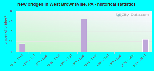
- New bridges - historical statistics
- 21910-1919
- 81960-1969
- 32010-2019

- Reconstructed bridges - Historical Statistics
- 11990-1999
- 12000-2009


- Bridge Condition - Deck
- 25.0%Very good
- 25.0%Good
- 50.0%Satisfactory

- Bridge Condition - Superstructure
- 25.0%Very good
- 75.0%Fair

- Bridge Condition - Substructure
- 25.0%Very good
- 50.0%Satisfactory
- 25.0%Fair

- Bridge Condition - Channel
- 33.3%Very good
- 33.3%Satisfactory
- 33.3%Fair
Find on map >> Show street view
Structure Number: 16965, Location: BROWNSVILLE & JEFFERSON T (Lat: 40.034122, Lng: -79.874847), Route carried "on" structure: State highway , Year Built: 1962, Status: Open, Structure Length: 4.75m (15.58ft), Average Daily Traffic: 1,889 (year 2022), Truck Traffic: 3%, Average Future Daily Traffic: 2,517 (year 2032), Design Load: H 20, Features Intersected: REDSTONE CREEK, Facility Carried by Structure: SR 4003
Minimum Vertical Clearance: 30+ m (98+ ft), Kilometerpoint: 9.143, Lanes on structure: 2, Owner: State Highway Agency, Approaching Roadway Width: 6.1m (20.0ft), Material/Design: Prestressed concrete, Design/Construction: Box Beam or Girders - Single/Spread, Number Of Spans In Main Unit: 3, Length of Maximum Span: 18.3m (60.0ft), Curb or Sidewalk Widths: Left: 0.5m (1.6ft), Right: 0.5m (1.6ft), Curb-To-Curb Width: 9.1m (29.9ft), Out-to-Out Width: 10.8m (35.4ft)
Condition: Deck: Satisfactory, Superstructure: Fair, Substructure: Satisfactory, Channel: Fair, Operating Rating: 48.1 metric tons, Method Used To Determine Operating Rating: Load Factor (LF), Inventory Rating: 29.0 metric tons, Method Used To Determine Inventory Rating: Load Factor (LF), Structural Evaluation: Somewhat better than minimum adequacy, Deck Geometry: Somewhat better than minimum adequacy, Waterway Adequacy: Somewhat better than minimum adequacy, Approach Roadway Alignment: Better than present minimum criteria, Length Of Structure Improvement: 5.70m (18.70ft), Designated Inspection Frequency: Every 24 months, Underwater Inspection Frequency: Every 60 months, Inspection Date: March 2021, Underwater Inspection Date: November 2020, Bridge Improvement Cost: $42,000, Roadway Improvement Cost: $123,000, Total Project Cost: $566,000, Deck Structure Type: Concrete Cast-file-Place, Wearing Surface/Protective System: Wearing Surface: Bituminous
Find on map >> Show street view
Structure Number: 34398, Location: BROWNSVILLE HIGH-LEVEL (Lat: 40.026583, Lng: -79.888461), Route carried "on" structure: US 40, Year Built: 1960, Year Reconstructed: 2002, Status: Open, Structure Length: 65.01m (213.29ft), Average Daily Traffic: 11,079 (year 2022), Truck Traffic: 4%, Average Future Daily Traffic: 12,056 (year 2035), Design Load: HS 25 or greater, Features Intersected: MON,0088,4003,4035,2 R/R
Minimum Vertical Clearance: 30+ m (98+ ft), Kilometerpoint: 60.574, Lanes on structure: 2, Lanes under structure: 12, Base Highway Network: Yes, Owner: State Highway Agency, Approaching Roadway Width: 19.5m (64.0ft), Skew: 31 degrees, Navigation Control: Yes ( Vertical Clearance: 999.7m (3,279.9ft), Horizontal Clearance: 9999.9m (32,808.1ft)), Material/Design: Steel continuous, Design/Construction: Truss - Deck, Number Of Spans In Main Unit: 3, Number Of Approach Spans: 9, Length of Maximum Span: 157.9m (518.0ft), Curb or Sidewalk Widths: Left: 0.8m (2.6ft), Right: 0.2m (0.7ft), Curb-To-Curb Width: 18.3m (60.0ft), Out-to-Out Width: 19.8m (65.0ft)
Condition: Deck: Satisfactory, Superstructure: Fair, Substructure: Fair, Channel: Satisfactory, Operating Rating: 60.8 metric tons, Method Used To Determine Operating Rating: Load Factor (LF), Inventory Rating: 36.3 metric tons, Method Used To Determine Inventory Rating: Load Factor (LF), Structural Evaluation: Somewhat better than minimum adequacy, Deck Geometry: Superior to present desirable criteria, Underclear: High priority of corrective action, Waterway Adequacy: Superior to present desirable criteria, Approach Roadway Alignment: Better than present minimum criteria, Length Of Structure Improvement: 65.00m (213.25ft), Designated Inspection Frequency: Every 24 months, Critical Feature Inspection Frequency: Every 24 months, Underwater Inspection Frequency: Every 60 months, Inspection Date: October 2021, Critical Feature Inspection Date: October 2021, Underwater Inspection Date: November 2020, Bridge Improvement Cost: $343,000, Roadway Improvement Cost: $1,009,000, Total Project Cost: $4,626,000, Deck Structure Type: Concrete Cast-file-Place, Wearing Surface/Protective System: Wearing Surface: Monolithic Concrete, Deck Protection: Epoxy Coated Reinforcing
Find on map >> Show street view
Structure Number: 35024, Location: OLD BROWNSVILLE BRIDGE (Lat: 40.022292, Lng: -79.889739), Route carried "on" structure: Spur State highway , Year Built: 1913, Year Reconstructed: 2011, Status: Open, Structure Length: 28.80m (94.49ft), Average Daily Traffic: 2,366 (year 2020), Truck Traffic: 1%, Average Future Daily Traffic: 3,420 (year 2032), Design Load: HS 25 or greater, Features Intersected: NS R/R, MON, CITY ST, Facility Carried by Structure: SR 2067
Minimum Vertical Clearance: 5.23m (17.16ft), Kilometerpoint: 0.000, Lanes on structure: 2, Lanes under structure: 2, Owner: State Highway Agency, Approaching Roadway Width: 11.6m (38.1ft), Navigation Control: Yes ( Vertical Clearance: 999.7m (3,279.9ft), Horizontal Clearance: 9999.9m (32,808.1ft)), Material/Design: Steel, Design/Construction: Truss - Thru, Number Of Spans In Main Unit: 1, Number Of Approach Spans: 7, Length of Maximum Span: 158.5m (520.0ft), Curb or Sidewalk Widths: Left: 1.8m (5.9ft), Right: 0.0m, Curb-To-Curb Width: 6.9m (22.6ft), Out-to-Out Width: 7.8m (25.6ft)
Condition: Deck: Good, Superstructure: Fair, Substructure: Satisfactory, Channel: Very good, Operating Rating: 58.1 metric tons, Method Used To Determine Operating Rating: Load Factor (LF), Inventory Rating: 34.5 metric tons, Method Used To Determine Inventory Rating: Load Factor (LF), Structural Evaluation: Somewhat better than minimum adequacy, Deck Geometry: High priority of replacement, Underclear: Meets minimum limits, Waterway Adequacy: Superior to present desirable criteria, Approach Roadway Alignment: Equal to present desirable criteria, Length Of Structure Improvement: 28.80m (94.49ft), Designated Inspection Frequency: Every 24 months, Critical Feature Inspection Frequency: Every 24 months, Underwater Inspection Frequency: Every 60 months, Inspection Date: May 2020, Critical Feature Inspection Date: May 2020, Underwater Inspection Date: November 2019, Bridge Improvement Cost: $101,000, Roadway Improvement Cost: $297,000, Total Project Cost: $1,361,000, Deck Structure Type: Concrete Cast-file-Place, Wearing Surface/Protective System: Wearing Surface: Monolithic Concrete, Deck Protection: Epoxy Coated Reinforcing
Find on map >> Show street view
Structure Number: 57111, Location: WEST BROWNSVILLE BOROUGH (Lat: 40.028150, Lng: -79.894611), Route carried "on" structure: Ramp State highway , Year Built: 2019, Status: Open, Structure Length: 3.44m (11.29ft), Average Daily Traffic: 1,736 (year 2022), Truck Traffic: 7%, Average Future Daily Traffic: 2,719 (year 2041), Design Load: HL 93, Features Intersected: SR 0040, Facility Carried by Structure: SR 8042
Minimum Vertical Clearance: 30+ m (98+ ft), Kilometerpoint: 0.000, Lanes on structure: 2, Lanes under structure: 4, Base Highway Network: Yes, Owner: State Highway Agency, Approaching Roadway Width: 14.0m (45.9ft), Skew: 22 degrees, Material/Design: Prestressed concrete, Design/Construction: Stringer/Multi-beam, Number Of Spans In Main Unit: 1, Length of Maximum Span: 33.5m (109.9ft), Curb or Sidewalk Widths: Left: 0.2m (0.7ft), Right: 0.2m (0.7ft), Curb-To-Curb Width: 14.0m (45.9ft), Out-to-Out Width: 15.1m (49.5ft)
Condition: Deck: Very good, Superstructure: Very good, Substructure: Very good, Operating Rating: 54.4 metric tons, Method Used To Determine Operating Rating: Assigned ratings based on Load and Resistance Factor Design (LRFD) reported by rating factor (RF) using HL93 loadings, Inventory Rating: 38.6 metric tons, Method Used To Determine Inventory Rating: Assigned ratings based on Load and Resistance Factor Design (LRFD) reported by rating factor (RF) using HL93 loadings, Structural Evaluation: Equal to present desirable criteria, Deck Geometry: Superior to present desirable criteria, Underclear: Meets minimum limits, Approach Roadway Alignment: Equal to present desirable criteria, Designated Inspection Frequency: Every 48 months, Inspection Date: November 2021, Deck Structure Type: Concrete Cast-file-Place, Wearing Surface/Protective System: Wearing Surface: Monolithic Concrete, Deck Protection: Epoxy Coated Reinforcing
Find on map >> Show street view
Structure Number: 34398, Location: BROWNSVILLE HIGH-LEVEL (Lat: 40.026583, Lng: -79.888461), Route carried "under" structure: State highway , Year Built: 1960, Structure Length: 0. m, Average Daily Traffic: 3,390 (year 2021), Truck Traffic: 4%, Features Intersected: MON,0088,4003,4035,2 R/R, Facility Carried by Structure: SR 0040
Minimum Vertical Clearance: 4.57m (14.99ft), Kilometerpoint: 0.000, Lanes on structure: 2, Lanes under structure: 2, Material/Design: Steel continuous, Design/Construction: Truss - Deck, Length of Maximum Span: 157.9m (518.0ft)
Find on map >> Show street view
Structure Number: 34398, Location: BROWNSVILLE HIGH-LEVEL (Lat: 40.026583, Lng: -79.888461), Route carried "under" structure: State highway 88, Year Built: 1960, Structure Length: 0. m, Average Daily Traffic: 774 (year 2021), Truck Traffic: 5%, Features Intersected: MON,0088,4003,4035,2 R/R, Facility Carried by Structure: SR 0040
Minimum Vertical Clearance: 15.03m (49.31ft), Kilometerpoint: 10.095, Lanes on structure: 2, Lanes under structure: 2, Material/Design: Steel continuous, Design/Construction: Truss - Deck, Length of Maximum Span: 157.9m (518.0ft)
Find on map >> Show street view
Structure Number: 34398, Location: BROWNSVILLE HIGH-LEVEL (Lat: 40.026583, Lng: -79.888461), Route carried "under" structure: State highway 88, Year Built: 1960, Structure Length: 0. m, Average Daily Traffic: 871 (year 2021), Truck Traffic: 4%, Features Intersected: MON,0088,4003,4035,2 R/R, Facility Carried by Structure: SR 0040
Minimum Vertical Clearance: 14.51m (47.60ft), Kilometerpoint: 10.078, Lanes on structure: 2, Lanes under structure: 2, Material/Design: Steel continuous, Design/Construction: Truss - Deck, Length of Maximum Span: 157.9m (518.0ft)
Find on map >> Show street view
Structure Number: 34398, Location: BROWNSVILLE HIGH-LEVEL (Lat: 40.026583, Lng: -79.888461), Route carried "under" structure: State highway , Year Built: 1960, Structure Length: 0. m, Average Daily Traffic: 1,889 (year 2022), Truck Traffic: 3%, Features Intersected: MON,0088,4003,4035,2 R/R, Facility Carried by Structure: SR 0040
Minimum Vertical Clearance: 23.01m (75.49ft), Kilometerpoint: 7.604, Lanes on structure: 2, Lanes under structure: 2, Material/Design: Steel continuous, Design/Construction: Truss - Deck, Length of Maximum Span: 157.9m (518.0ft)
Find on map >> Show street view
Structure Number: 34398, Location: BROWNSVILLE HIGH-LEVEL (Lat: 40.026583, Lng: -79.888461), Route carried "under" structure: State highway , Year Built: 1960, Structure Length: 0. m, Average Daily Traffic: 770 (year 2021), Truck Traffic: 5%, Features Intersected: MON,0088,4003,4035,2 R/R, Facility Carried by Structure: SR 0040
Minimum Vertical Clearance: 15.03m (49.31ft), Kilometerpoint: 4.543, Lanes on structure: 2, Lanes under structure: 2, Material/Design: Steel continuous, Design/Construction: Truss - Deck, Length of Maximum Span: 157.9m (518.0ft)
Find on map >> Show street view
Structure Number: 34398, Location: BROWNSVILLE HIGH-LEVEL (Lat: 40.026583, Lng: -79.888461), Route carried "under" structure: State highway , Year Built: 1960, Structure Length: 0. m, Average Daily Traffic: 770 (year 2021), Truck Traffic: 5%, Features Intersected: MON,0088,4003,4035,2 R/R, Facility Carried by Structure: SR 0040
Minimum Vertical Clearance: 14.50m (47.57ft), Kilometerpoint: 4.543, Lanes on structure: 2, Lanes under structure: 2, Material/Design: Steel continuous, Design/Construction: Truss - Deck, Length of Maximum Span: 157.9m (518.0ft)
Find on map >> Show street view
Structure Number: 35024, Location: OLD BROWNSVILLE BRIDGE (Lat: 40.022292, Lng: -79.889739), Route carried "under" structure: City street , Year Built: 1913, Structure Length: 0. m, Features Intersected: NS R/R, MON, CITY ST, Facility Carried by Structure: SR 2067
Minimum Vertical Clearance: 4.57m (14.99ft), Kilometerpoint: 0.000, Lanes on structure: 2, Lanes under structure: 2, Material/Design: Steel, Design/Construction: Truss - Thru, Length of Maximum Span: 158.5m (520.0ft)
Find on map >> Show street view
Structure Number: 57111, Location: WEST BROWNSVILLE BOROUGH (Lat: 40.028150, Lng: -79.894611), Route carried "under" structure: US 40, Year Built: 2019, Structure Length: 0. m, Average Daily Traffic: 4,391 (year 2020), Truck Traffic: 4%, Features Intersected: SR 0040, Facility Carried by Structure: SR 8042
Minimum Vertical Clearance: 5.16m (16.93ft), Kilometerpoint: 59.747, Lanes on structure: 2, Lanes under structure: 2, Material/Design: Prestressed concrete, Design/Construction: Stringer/Multi-beam, Length of Maximum Span: 33.5m (109.9ft)
Find on map >> Show street view
Structure Number: 57111, Location: WEST BROWNSVILLE BOROUGH (Lat: 40.028150, Lng: -79.894611), Route carried "under" structure: US 40, Year Built: 2019, Structure Length: 0. m, Average Daily Traffic: 5,655 (year 2022), Truck Traffic: 4%, Features Intersected: SR 0040, Facility Carried by Structure: SR 8042
Minimum Vertical Clearance: 5.21m (17.09ft), Kilometerpoint: 59.905, Lanes on structure: 2, Lanes under structure: 2, Material/Design: Prestressed concrete, Design/Construction: Stringer/Multi-beam, Length of Maximum Span: 33.5m (109.9ft)