Bridge Statistics for Wellesley, Massachusetts (MA)
Condition, Traffic, Stress, Structural Evaluation, Project Costs
- National Bridge Inventory (NBI) Statistics
- 19Number of bridges
- 125ft / 38.0mTotal length
- $31,745,000Total costs
- 710,568Total average daily traffic
- 25,056Total average daily truck traffic
- National Bridge Inventory (NBI) Registered Bridges for Wellesley
- No street view available for this location
- New bridges - historical statistics
- 5Before 1900
- 11910-1919
- 101930-1939
- 21990-1999
- 12010-2019
- Reconstructed bridges - Historical Statistics
- 11920-1929
- 01930-1939
- 01940-1949
- 01950-1959
- 01960-1969
- 01970-1979
- 01980-1989
- 51990-1999
- 32000-2009
- Bridge Condition - Deck
- 75.0%Good
- 25.0%Satisfactory
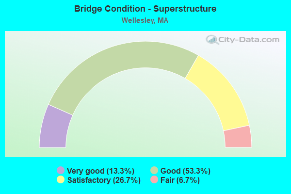
- Bridge Condition - Superstructure
- 13.3%Very good
- 53.3%Good
- 26.7%Satisfactory
- 6.7%Fair
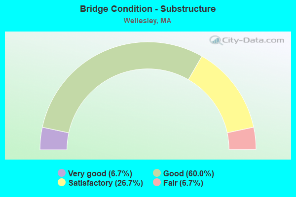
- Bridge Condition - Substructure
- 6.7%Very good
- 60.0%Good
- 26.7%Satisfactory
- 6.7%Fair
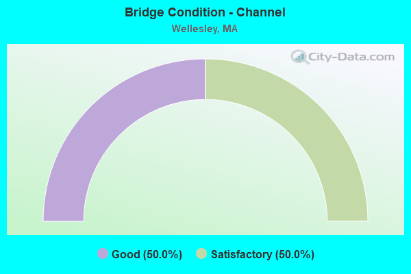
- Bridge Condition - Channel
- 50.0%Good
- 50.0%Satisfactory
Find on map >> Show street view
Structure Number: D100074D8DOTNBI, Location: 0.8 KM N. OF BRIDGE ST (Lat: 42.275794, Lng: -71.309569), Route carried "on" structure: State lands road , Year Built: 1897, Year Reconstructed: 1990, Status: Posted for load, Structure Length: 1.95m (6.40ft), Average Daily Traffic: 1,164 (year 2019), Truck Traffic: 1%, Average Future Daily Traffic: 2,527 (year 2032), Features Intersected: WATER CHARLES RIVER, Facility Carried by Structure: HWY CHENEY DRIVE
Minimum Vertical Clearance: 30+ m (98+ ft), Kilometerpoint: 0.805, Lanes on structure: 1, Owner: State Highway Agency, Approaching Roadway Width: 5.5m (18.0ft), Skew: 4 degrees, Material/Design: Steel, Design/Construction: Arch - Deck, Number Of Spans In Main Unit: 1, Length of Maximum Span: 18.4m (60.4ft), Curb or Sidewalk Widths: Left: 0.8m (2.6ft), Right: 0.8m (2.6ft), Curb-To-Curb Width: 3.7m (12.1ft), Out-to-Out Width: 6.1m (20.0ft)
Condition: Deck: Satisfactory, Superstructure: Fair, Substructure: Satisfactory, Channel: Satisfactory, Operating Rating: 26.9 metric tons, Method Used To Determine Operating Rating: Load Factor (LF), Inventory Rating: 16.1 metric tons, Method Used To Determine Inventory Rating: Load Factor (LF), Structural Evaluation: Meets minimum limits, Deck Geometry: High priority of replacement, Waterway Adequacy: Better than present minimum criteria, Approach Roadway Alignment: High priority of corrective action, Bridge Posting: Required (Relationship of Operating Rating to Maximum Legal Load: 10.0 - 19.9% below), Length Of Structure Improvement: 2.70m (8.86ft), Designated Inspection Frequency: Every 24 months, Critical Feature Inspection Frequency: Every 24 months, Underwater Inspection Frequency: Every 36 months, Inspection Date: September 2021, Critical Feature Inspection Date: September 2021, Underwater Inspection Date: August 2021, Bridge Improvement Cost: $2,244,000, Roadway Improvement Cost: $225,000, Total Project Cost: $3,367,000 ( Estimate for 2022), Deck Structure Type: Wood or Timber, Wearing Surface/Protective System: Wearing Surface: Wood or Timber
Find on map >> Show street view
Structure Number: D100084D9DOTNBI, Location: IN DOVER (Lat: 42.277292, Lng: -71.305014), Route carried "on" structure: State lands road , Year Built: 1850, Year Reconstructed: 1925, Status: Open, Structure Length: 1.37m (4.49ft), Average Daily Traffic: 260 (year 2020), Average Future Daily Traffic: 632 (year 2031), Features Intersected: WATER CHARLES RIVER INLT, Facility Carried by Structure: HWY ELM BANK RD
Minimum Vertical Clearance: 30+ m (98+ ft), Kilometerpoint: 1.448, Lanes on structure: 1, Owner: State Highway Agency, Approaching Roadway Width: 4.3m (14.1ft), Material/Design: Concrete, Design/Construction: Arch - Deck, Number Of Spans In Main Unit: 2, Length of Maximum Span: 4.6m (15.1ft), Curb-To-Curb Width: 3.0m (9.8ft), Out-to-Out Width: 4.3m (14.1ft)
Condition: Superstructure: Satisfactory, Substructure: Good, Channel: Good, Operating Rating: 58.2 metric tons, Method Used To Determine Operating Rating: Load Factor (LF), Inventory Rating: 34.8 metric tons, Method Used To Determine Inventory Rating: Load Factor (LF), Structural Evaluation: Equal to present minimum criteria, Deck Geometry: High priority of replacement, Waterway Adequacy: Better than present minimum criteria, Approach Roadway Alignment: Better than present minimum criteria, Length Of Structure Improvement: 2.10m (6.89ft), Designated Inspection Frequency: Every 24 months, Underwater Inspection Frequency: Every 24 months, Inspection Date: March 2020, Underwater Inspection Date: December 2020, Bridge Improvement Cost: $1,353,000, Roadway Improvement Cost: $136,000, Total Project Cost: $2,030,000 ( Estimate for 2022)
Find on map >> Show street view
Structure Number: W130042P9DOT634, Location: 0.5 MI WEST RTE 16 (Lat: 42.323617, Lng: -71.271983), Route carried "on" structure: City street , Year Built: 1993, Status: Open, Structure Length: 1.85m (6.07ft), Average Daily Traffic: 5,400 (year 2019), Truck Traffic: 10%, Average Future Daily Traffic: 10,897 (year 2032), Design Load: H 20, Features Intersected: RR CSX/MBTA, Facility Carried by Structure: HWY GLEN RD
Minimum Vertical Clearance: 30+ m (98+ ft), Kilometerpoint: 0.000, Lanes on structure: 2, Owner: State Highway Agency, Approaching Roadway Width: 8.5m (27.9ft), Material/Design: Prestressed concrete, Design/Construction: Box Beam or Girders - Multiple, Number Of Spans In Main Unit: 1, Length of Maximum Span: 17.7m (58.1ft), Curb or Sidewalk Widths: Left: 1.5m (4.9ft), Right: 0.2m (0.7ft), Curb-To-Curb Width: 8.5m (27.9ft), Out-to-Out Width: 11.1m (36.4ft)
Condition: Deck: Satisfactory, Superstructure: Satisfactory, Substructure: Good, Operating Rating: 59.1 metric tons, Method Used To Determine Operating Rating: Allowable Stress (AS), Inventory Rating: 42.7 metric tons, Method Used To Determine Inventory Rating: Allowable Stress (AS), Structural Evaluation: Equal to present minimum criteria, Deck Geometry: High priority of replacement, Underclear: High priority of replacement, Approach Roadway Alignment: High priority of corrective action, Length Of Structure Improvement: 2.60m (8.53ft), Designated Inspection Frequency: Every 24 months, Inspection Date: October 2021, Bridge Improvement Cost: $2,180,000, Roadway Improvement Cost: $219,000, Total Project Cost: $3,271,000 ( Estimate for 2022), Deck Structure Type: Concrete Precast Panels, Wearing Surface/Protective System: Wearing Surface: Bituminous, Membrane: Built-up, Deck Protection: Epoxy Coated Reinforcing
Find on map >> Show street view
Structure Number: W130052P8DOT634, Location: .48 KM NW RTE 16 (Lat: 42.318458, Lng: -71.273883), Route carried "on" structure: City street , Year Built: 1890, Year Reconstructed: 2003, Status: Open, Structure Length: 2.76m (9.06ft), Average Daily Traffic: 3,400 (year 2019), Truck Traffic: 15%, Average Future Daily Traffic: 3,159 (year 2032), Design Load: HS 20, Features Intersected: RR CSX/MBTA, Facility Carried by Structure: HWY WOODLAWN AVE
Minimum Vertical Clearance: 30+ m (98+ ft), Kilometerpoint: 0.000, Lanes on structure: 2, Owner: State Highway Agency, Approaching Roadway Width: 7.3m (24.0ft), Skew: 3 degrees, Material/Design: Steel, Design/Construction: Stringer/Multi-beam, Number Of Spans In Main Unit: 1, Length of Maximum Span: 25.5m (83.7ft), Curb or Sidewalk Widths: Left: 1.5m (4.9ft), Right: 1.5m (4.9ft), Curb-To-Curb Width: 7.3m (24.0ft), Out-to-Out Width: 11.1m (36.4ft)
Condition: Deck: Good, Superstructure: Good, Substructure: Good, Operating Rating: 83.7 metric tons, Method Used To Determine Operating Rating: Load Factor (LF), Inventory Rating: 50.2 metric tons, Method Used To Determine Inventory Rating: Load Factor (LF), Structural Evaluation: Better than present minimum criteria, Deck Geometry: High priority of replacement, Underclear: Somewhat better than minimum adequacy, Approach Roadway Alignment: Equal to present minimum criteria, Length Of Structure Improvement: 2.80m (9.19ft), Designated Inspection Frequency: Every 24 months, Inspection Date: October 2021, Bridge Improvement Cost: $1,611,000, Roadway Improvement Cost: $162,000, Total Project Cost: $2,417,000 ( Estimate for 2022), Deck Structure Type: Concrete Cast-file-Place, Wearing Surface/Protective System: Wearing Surface: Bituminous, Membrane: Built-up, Deck Protection: Epoxy Coated Reinforcing
Find on map >> Show street view
Structure Number: W130062P3DOT634, Location: 0.40 KM WLY RT 16 (Lat: 42.312242, Lng: -71.276292), Route carried "on" structure: State highway 9, Year Built: 1932, Year Reconstructed: 1996, Status: Open, Structure Length: 2.83m (9.28ft), Average Daily Traffic: 33,750 (year 2020), Truck Traffic: 8%, Average Future Daily Traffic: 86,862 (year 2031), Design Load: HS 20, Features Intersected: RR CSX/MBTA
Minimum Vertical Clearance: 30+ m (98+ ft), Kilometerpoint: 212.428, Lanes on structure: 4, Base Highway Network: Yes, Owner: State Highway Agency, Approaching Roadway Width: 17.4m (57.1ft), Skew: 34 degrees, Material/Design: Steel, Design/Construction: Stringer/Multi-beam, Number Of Spans In Main Unit: 1, Number Of Approach Spans: 2, Length of Maximum Span: 25.4m (83.3ft), Curb or Sidewalk Widths: Left: 2.1m (6.9ft), Right: 2.1m (6.9ft), Curb-To-Curb Width: 17.4m (57.1ft), Out-to-Out Width: 23.8m (78.1ft)
Condition: Deck: Good, Superstructure: Good, Substructure: Satisfactory, Operating Rating: 67.5 metric tons, Method Used To Determine Operating Rating: Load Factor (LF), Inventory Rating: 40.4 metric tons, Method Used To Determine Inventory Rating: Load Factor (LF), Structural Evaluation: Equal to present minimum criteria, Deck Geometry: Somewhat better than minimum adequacy, Underclear: Meets minimum limits, Approach Roadway Alignment: Equal to present minimum criteria, Length Of Structure Improvement: 2.90m (9.51ft), Designated Inspection Frequency: Every 24 months, Inspection Date: March 2020, Bridge Improvement Cost: $1,286,000, Roadway Improvement Cost: $129,000, Total Project Cost: $1,930,000 ( Estimate for 2022), Deck Structure Type: Concrete Cast-file-Place, Wearing Surface/Protective System: Wearing Surface: Bituminous, Membrane: Built-up, Deck Protection: Epoxy Coated Reinforcing
Find on map >> Show street view
Structure Number: W130072P7DOT634, Location: .08 KM NLY RTE 16 (Lat: 42.308478, Lng: -71.278733), Route carried "on" structure: City street , Year Built: 1917, Year Reconstructed: 2012, Status: Open, Structure Length: 2.07m (6.79ft), Average Daily Traffic: 5,800 (year 2019), Truck Traffic: 2%, Average Future Daily Traffic: 5,528 (year 2032), Design Load: HS 25 or greater, Features Intersected: RR CSX/MBTA, Facility Carried by Structure: HWY ROCKLAND ST
Minimum Vertical Clearance: 30+ m (98+ ft), Kilometerpoint: 0.080, Lanes on structure: 2, Owner: State Highway Agency, Approaching Roadway Width: 9.2m (30.2ft), Skew: 1 degrees, Material/Design: Prestressed concrete, Design/Construction: Box Beam or Girders - Multiple, Number Of Spans In Main Unit: 1, Length of Maximum Span: 19.2m (63.0ft), Curb or Sidewalk Widths: Left: 0.0m, Right: 1.8m (5.9ft), Curb-To-Curb Width: 9.2m (30.2ft), Out-to-Out Width: 11.8m (38.7ft)
Condition: Deck: Good, Superstructure: Good, Substructure: Good, Operating Rating: 27.1 metric tons, Method Used To Determine Operating Rating: Allowable Stress (AS), Inventory Rating: 18.6 metric tons, Method Used To Determine Inventory Rating: Allowable Stress (AS), Structural Evaluation: Meets minimum limits, Deck Geometry: High priority of corrective action, Underclear: High priority of corrective action, Approach Roadway Alignment: Meets minimum limits, Bridge Posting: Required (Relationship of Operating Rating to Maximum Legal Load: 10.0 - 19.9% below), Length Of Structure Improvement: 2.10m (6.89ft), Designated Inspection Frequency: Every 24 months, Inspection Date: March 2021, Bridge Improvement Cost: $974,000, Roadway Improvement Cost: $98,000, Total Project Cost: $1,462,000 ( Estimate for 2022), Deck Structure Type: Concrete Precast Panels, Wearing Surface/Protective System: Wearing Surface: Monolithic Concrete, Deck Protection: Epoxy Coated Reinforcing
Find on map >> Show street view
Structure Number: W130082P4DOT634, Location: .16 KM NW RT 16 (Lat: 42.302417, Lng: -71.287067), Route carried "on" structure: City street , Year Built: 1889, Year Reconstructed: 1996, Status: Open, Structure Length: 2.32m (7.61ft), Average Daily Traffic: 14,870 (year 2019), Truck Traffic: 1%, Average Future Daily Traffic: 28,427 (year 2032), Design Load: HS 20, Features Intersected: RR CSX/MBTA, Facility Carried by Structure: HWY KINGSBURY ST
Minimum Vertical Clearance: 30+ m (98+ ft), Kilometerpoint: 0.161, Lanes on structure: 2, Owner: State Highway Agency, Approaching Roadway Width: 7.3m (24.0ft), Skew: 1 degrees, Material/Design: Steel, Design/Construction: Truss - Thru, Number Of Spans In Main Unit: 1, Length of Maximum Span: 21.6m (70.9ft), Curb or Sidewalk Widths: Left: 1.5m (4.9ft), Right: 1.5m (4.9ft), Curb-To-Curb Width: 7.3m (24.0ft), Out-to-Out Width: 14.8m (48.6ft)
Condition: Deck: Good, Superstructure: Good, Substructure: Good, Operating Rating: 34.7 metric tons, Method Used To Determine Operating Rating: Load Factor (LF), Inventory Rating: 20.7 metric tons, Method Used To Determine Inventory Rating: Load Factor (LF), Structural Evaluation: Somewhat better than minimum adequacy, Deck Geometry: High priority of replacement, Underclear: High priority of corrective action, Approach Roadway Alignment: Somewhat better than minimum adequacy, Length Of Structure Improvement: 2.40m (7.87ft), Designated Inspection Frequency: Every 24 months, Critical Feature Inspection Frequency: Every 24 months, Inspection Date: September 2021, Critical Feature Inspection Date: September 2021, Bridge Improvement Cost: $1,396,000, Roadway Improvement Cost: $140,000, Total Project Cost: $2,095,000 ( Estimate for 2022), Deck Structure Type: Concrete Cast-file-Place, Wearing Surface/Protective System: Wearing Surface: Latex Concrete, Membrane: Built-up, Deck Protection: Epoxy Coated Reinforcing
Find on map >> Show street view
Structure Number: W130092P6DOT634, Location: .16 KM NWLY RT 16 (Lat: 42.297108, Lng: -71.295042), Route carried "on" structure: City street , Year Built: 1895, Year Reconstructed: 1997, Status: Open, Structure Length: 2.10m (6.89ft), Average Daily Traffic: 10,200 (year 2018), Truck Traffic: 4%, Average Future Daily Traffic: 21,163 (year 2033), Design Load: HS 20, Features Intersected: RR CSX/MBTA, Facility Carried by Structure: HWY CREST RD
Minimum Vertical Clearance: 30+ m (98+ ft), Kilometerpoint: 0.000, Lanes on structure: 2, Owner: State Highway Agency, Approaching Roadway Width: 8.5m (27.9ft), Skew: 1 degrees, Material/Design: Prestressed concrete, Design/Construction: Box Beam or Girders - Multiple, Number Of Spans In Main Unit: 1, Length of Maximum Span: 19.5m (64.0ft), Curb or Sidewalk Widths: Left: 1.8m (5.9ft), Right: 1.8m (5.9ft), Curb-To-Curb Width: 8.5m (27.9ft), Out-to-Out Width: 12.1m (39.7ft)
Condition: Deck: Good, Superstructure: Good, Substructure: Good, Operating Rating: 85.9 metric tons, Method Used To Determine Operating Rating: Load Factor (LF), Inventory Rating: 51.5 metric tons, Method Used To Determine Inventory Rating: Load Factor (LF), Structural Evaluation: Better than present minimum criteria, Deck Geometry: High priority of replacement, Underclear: High priority of corrective action, Approach Roadway Alignment: Equal to present minimum criteria, Length Of Structure Improvement: 2.20m (7.22ft), Designated Inspection Frequency: Every 24 months, Inspection Date: March 2020, Bridge Improvement Cost: $1,017,000, Roadway Improvement Cost: $102,000, Total Project Cost: $1,526,000 ( Estimate for 2022), Deck Structure Type: Concrete Precast Panels, Wearing Surface/Protective System: Wearing Surface: Bituminous, Membrane: Built-up, Deck Protection: Epoxy Coated Reinforcing
Find on map >> Show street view
Structure Number: W130102P5DOT634, Location: 0.8 KM N RTE 135 (Lat: 42.296292, Lng: -71.299367), Route carried "on" structure: City street , Year Built: 1997, Status: Open, Structure Length: 2.23m (7.32ft), Average Daily Traffic: 18,600 (year 2019), Truck Traffic: 5%, Average Future Daily Traffic: 33,955 (year 2032), Design Load: HS 20, Features Intersected: RR CSX/MBTA, Facility Carried by Structure: HWY WESTON RD
Minimum Vertical Clearance: 30+ m (98+ ft), Kilometerpoint: 0.000, Lanes on structure: 2, Owner: State Highway Agency, Approaching Roadway Width: 10.4m (34.1ft), Skew: 1 degrees, Material/Design: Steel, Design/Construction: Stringer/Multi-beam, Number Of Spans In Main Unit: 1, Length of Maximum Span: 20.2m (66.3ft), Curb or Sidewalk Widths: Left: 0.0m, Right: 1.8m (5.9ft), Curb-To-Curb Width: 10.4m (34.1ft), Out-to-Out Width: 13.3m (43.6ft)
Condition: Deck: Good, Superstructure: Very good, Substructure: Good, Operating Rating: 68.1 metric tons, Method Used To Determine Operating Rating: Load Factor (LF), Inventory Rating: 43.4 metric tons, Method Used To Determine Inventory Rating: Load Factor (LF), Structural Evaluation: Better than present minimum criteria, Deck Geometry: Meets minimum limits, Underclear: High priority of corrective action, Approach Roadway Alignment: Equal to present minimum criteria, Length Of Structure Improvement: 2.30m (7.55ft), Designated Inspection Frequency: Every 24 months, Inspection Date: August 2021, Bridge Improvement Cost: $651,000, Roadway Improvement Cost: $66,000, Total Project Cost: $977,000 ( Estimate for 2022), Deck Structure Type: Concrete Cast-file-Place, Wearing Surface/Protective System: Wearing Surface: Latex Concrete, Deck Protection: Epoxy Coated Reinforcing
Find on map >> Show street view
Structure Number: W130132EKDOTNBI, Location: 2.4 MI WLY RT 16 (Lat: 42.305372, Lng: -71.312744), Route carried "on" structure: US 9, Year Built: 1932, Status: Open, Structure Length: 1.52m (4.99ft), Average Daily Traffic: 66,000 (year 2019), Truck Traffic: 6%, Average Future Daily Traffic: 105,655 (year 2032), Design Load: H 20, Features Intersected: HWY WESTON RD
Minimum Vertical Clearance: 30+ m (98+ ft), Kilometerpoint: 197.229, Lanes on structure: 4, Lanes under structure: 2, Base Highway Network: Yes, Owner: State Highway Agency, Approaching Roadway Width: 18.9m (62.0ft), Skew: 23 degrees, Material/Design: Concrete, Design/Construction: Frame, Number Of Spans In Main Unit: 1, Length of Maximum Span: 15.2m (49.9ft), Curb or Sidewalk Widths: Left: 2.5m (8.2ft), Right: 2.5m (8.2ft), Curb-To-Curb Width: 18.9m (62.0ft), Out-to-Out Width: 28.9m (94.8ft)
Condition: Superstructure: Good, Substructure: Good, Operating Rating: 55.1 metric tons, Method Used To Determine Operating Rating: Allowable Stress (AS), Inventory Rating: 14.5 metric tons, Method Used To Determine Inventory Rating: Allowable Stress (AS), Structural Evaluation: High priority of corrective action, Deck Geometry: Equal to present minimum criteria, Underclear: High priority of corrective action, Approach Roadway Alignment: Better than present minimum criteria, Length Of Structure Improvement: 1.60m (5.25ft), Designated Inspection Frequency: Every 24 months, Inspection Date: July 2021, Bridge Improvement Cost: $1,817,000, Roadway Improvement Cost: $182,000, Total Project Cost: $2,726,000 ( Estimate for 2022), Wearing Surface/Protective System: Wearing Surface: Bituminous
Find on map >> Show street view
Structure Number: W130142E9DOTNBI, Location: RT 16 AT RT 9 (Lat: 42.314194, Lng: -71.272306), Route carried "on" structure: State highway 16, Year Built: 1932, Year Reconstructed: 2009, Status: Open, Structure Length: 4.57m (14.99ft), Average Daily Traffic: 42,000 (year 2019), Truck Traffic: 1%, Average Future Daily Traffic: 85,440 (year 2032), Design Load: HS 20, Features Intersected: ST 9 WORCESTER ST
Minimum Vertical Clearance: 30+ m (98+ ft), Kilometerpoint: 65.651, Lanes on structure: 3, Lanes under structure: 4, Base Highway Network: Yes, Owner: State Highway Agency, Approaching Roadway Width: 12.2m (40.0ft), Skew: 3 degrees, Material/Design: Steel, Design/Construction: Girder and Floorbeam System, Number Of Spans In Main Unit: 2, Length of Maximum Span: 22.9m (75.1ft), Curb or Sidewalk Widths: Left: 2.6m (8.5ft), Right: 2.6m (8.5ft), Curb-To-Curb Width: 12.2m (40.0ft), Out-to-Out Width: 18.6m (61.0ft)
Condition: Deck: Good, Superstructure: Good, Substructure: Satisfactory, Operating Rating: 74.3 metric tons, Method Used To Determine Operating Rating: Load Factor (LF), Inventory Rating: 44.5 metric tons, Method Used To Determine Inventory Rating: Load Factor (LF), Structural Evaluation: Equal to present minimum criteria, Deck Geometry: Meets minimum limits, Underclear: High priority of corrective action, Approach Roadway Alignment: Equal to present desirable criteria, Length Of Structure Improvement: 4.60m (15.09ft), Designated Inspection Frequency: Every 24 months, Inspection Date: March 2021, Bridge Improvement Cost: $2,689,000, Roadway Improvement Cost: $269,000, Total Project Cost: $4,034,000 ( Estimate for 2022), Deck Structure Type: Concrete Cast-file-Place, Wearing Surface/Protective System: Wearing Surface: Bituminous
Find on map >> Show street view
Structure Number: W130152MHDOTNBI, Location: 1.1 KM WLY RT 128 (Lat: 42.315658, Lng: -71.246639), Route carried "on" structure: City street , Year Built: 1932, Year Reconstructed: 2011, Status: Open, Structure Length: 2.53m (8.30ft), Average Daily Traffic: 26,400 (year 2019), Truck Traffic: 1%, Average Future Daily Traffic: 30,796 (year 2032), Design Load: HS 25 or greater, Features Intersected: ST 9 WORCESTER ST, Facility Carried by Structure: HWY CEDAR ST
Minimum Vertical Clearance: 30+ m (98+ ft), Kilometerpoint: 0.000, Lanes on structure: 2, Lanes under structure: 4, Owner: State Highway Agency, Approaching Roadway Width: 12.2m (40.0ft), Material/Design: Steel continuous, Design/Construction: Stringer/Multi-beam, Number Of Spans In Main Unit: 2, Length of Maximum Span: 12.6m (41.3ft), Curb or Sidewalk Widths: Left: 1.5m (4.9ft), Right: 1.8m (5.9ft), Curb-To-Curb Width: 11.9m (39.0ft), Out-to-Out Width: 16.3m (53.5ft)
Condition: Deck: Good, Superstructure: Good, Substructure: Satisfactory, Operating Rating: 77.8 metric tons, Method Used To Determine Operating Rating: Load Factor (LF), Inventory Rating: 46.3 metric tons, Method Used To Determine Inventory Rating: Load Factor (LF), Structural Evaluation: Equal to present minimum criteria, Deck Geometry: Somewhat better than minimum adequacy, Underclear: High priority of corrective action, Approach Roadway Alignment: Equal to present desirable criteria, Length Of Structure Improvement: 2.60m (8.53ft), Designated Inspection Frequency: Every 24 months, Inspection Date: September 2021, Bridge Improvement Cost: $368,000, Roadway Improvement Cost: $37,000, Total Project Cost: $553,000 ( Estimate for 2022), Deck Structure Type: Concrete Cast-file-Place, Wearing Surface/Protective System: Wearing Surface: Bituminous, Membrane: Epoxy
Find on map >> Show street view
Structure Number: W130162EJDOTNBI, Location: 0.35 MI WLY RT 16 (Lat: 42.311933, Lng: -71.277075), Route carried "on" structure: State highway 9, Year Built: 1932, Status: Open, Structure Length: 1.52m (4.99ft), Average Daily Traffic: 100,500 (year 2019), Truck Traffic: 3%, Average Future Daily Traffic: 84,650 (year 2032), Design Load: H 20, Features Intersected: HWY CLIFF RD
Minimum Vertical Clearance: 30+ m (98+ ft), Kilometerpoint: 200.310, Lanes on structure: 4, Lanes under structure: 2, Base Highway Network: Yes, Owner: State Highway Agency, Approaching Roadway Width: 17.4m (57.1ft), Skew: 30 degrees, Material/Design: Concrete, Design/Construction: Frame, Number Of Spans In Main Unit: 1, Length of Maximum Span: 15.2m (49.9ft), Curb or Sidewalk Widths: Left: 1.9m (6.2ft), Right: 1.9m (6.2ft), Curb-To-Curb Width: 17.4m (57.1ft), Out-to-Out Width: 23.8m (78.1ft)
Condition: Superstructure: Satisfactory, Substructure: Good, Operating Rating: 55.1 metric tons, Method Used To Determine Operating Rating: Allowable Stress (AS), Inventory Rating: 16.5 metric tons, Method Used To Determine Inventory Rating: Allowable Stress (AS), Structural Evaluation: Meets minimum limits, Deck Geometry: Somewhat better than minimum adequacy, Underclear: High priority of corrective action, Approach Roadway Alignment: Better than present minimum criteria, Length Of Structure Improvement: 1.60m (5.25ft), Designated Inspection Frequency: Every 24 months, Inspection Date: January 2021, Bridge Improvement Cost: $1,496,000, Roadway Improvement Cost: $150,000, Total Project Cost: $2,245,000 ( Estimate for 2022), Wearing Surface/Protective System: Wearing Surface: Bituminous, Membrane: Built-up
Find on map >> Show street view
Structure Number: W130172MJDOTNBI, Location: BETWEEN RT 9 & RT 16 (Lat: 42.311311, Lng: -71.276664), Route carried "on" structure: City street , Year Built: 1932, Status: Open, Structure Length: 3.29m (10.79ft), Average Daily Traffic: 9,827 (year 2018), Truck Traffic: 5%, Average Future Daily Traffic: 22,742 (year 2031), Design Load: H 20, Features Intersected: RR CSX/MBTA, Facility Carried by Structure: HWY CLIFF RD
Minimum Vertical Clearance: 30+ m (98+ ft), Kilometerpoint: 0.000, Lanes on structure: 2, Owner: State Highway Agency, Approaching Roadway Width: 11.0m (36.1ft), Skew: 4 degrees, Material/Design: Steel, Design/Construction: Girder and Floorbeam System, Number Of Spans In Main Unit: 1, Length of Maximum Span: 31.4m (103.0ft), Curb or Sidewalk Widths: Left: 1.4m (4.6ft), Right: 1.4m (4.6ft), Curb-To-Curb Width: 11.0m (36.1ft), Out-to-Out Width: 16.0m (52.5ft)
Condition: Deck: Satisfactory, Superstructure: Satisfactory, Substructure: Fair, Operating Rating: 60.3 metric tons, Method Used To Determine Operating Rating: Load Factor (LF), Inventory Rating: 36.1 metric tons, Method Used To Determine Inventory Rating: Load Factor (LF), Structural Evaluation: Somewhat better than minimum adequacy, Deck Geometry: Meets minimum limits, Underclear: High priority of corrective action, Approach Roadway Alignment: Equal to present minimum criteria, Length Of Structure Improvement: 3.30m (10.83ft), Designated Inspection Frequency: Every 24 months, Critical Feature Inspection Frequency: Every 24 months, Inspection Date: March 2020, Critical Feature Inspection Date: March 2020, Bridge Improvement Cost: $2,074,000, Roadway Improvement Cost: $208,000, Total Project Cost: $3,112,000 ( Estimate for 2022), Deck Structure Type: Concrete Cast-file-Place, Wearing Surface/Protective System: Wearing Surface: Bituminous, Membrane: Built-up
Find on map >> Show street view
Structure Number: W13023BDHDOTNBI, Location: RT 128 AT RT 9 (Lat: 42.316708, Lng: -71.234019), Route carried "on" structure: Interstate 95, Year Built: 2018, Status: Open, Structure Length: 5.14m (16.86ft), Average Daily Traffic: 192,397 (year 2016), Truck Traffic: 6%, Design Load: HL 93, Features Intersected: ST 9 WORCESTER ST
Minimum Vertical Clearance: 4.95m (16.24ft), Kilometerpoint: 58.900, Lanes on structure: 8, Lanes under structure: 6, Owner: State Highway Agency, Approaching Roadway Width: 47.1m (154.5ft), Skew: 2 degrees, Material/Design: Steel continuous, Design/Construction: Stringer/Multi-beam, Number Of Spans In Main Unit: 2, Length of Maximum Span: 25.1m (82.3ft), Curb-To-Curb Width: 46.1m (151.2ft), Out-to-Out Width: 47.1m (154.5ft)
Condition: Deck: Good, Superstructure: Very good, Substructure: Very good, Operating Rating: 42.1 metric tons, Method Used To Determine Operating Rating: Assigned ratings based on Load and Resistance Factor Design (LRFD) reported by rating factor (RF) using HL93 loadings, Inventory Rating: 32.4 metric tons, Method Used To Determine Inventory Rating: Assigned ratings based on Load and Resistance Factor Design (LRFD) reported by rating factor (RF) using HL93 loadings, Structural Evaluation: Equal to present desirable criteria, Deck Geometry: Superior to present desirable criteria, Underclear: Better than present minimum criteria, Approach Roadway Alignment: Equal to present desirable criteria, Designated Inspection Frequency: Every 24 months, Inspection Date: October 2020, Deck Structure Type: Concrete Cast-file-Place, Wearing Surface/Protective System: Wearing Surface: Bituminous, Membrane: Other, Deck Protection: Epoxy Coated Reinforcing
Find on map >> Show street view
Structure Number: W130142E9DOTNBI, Location: RT 16 AT RT 9 (Lat: 42.316667, Lng: -71.266667), Route carried "under" structure: State highway 9, Year Built: 1932, Structure Length: 0. m, Average Daily Traffic: 45,000 (year 0000), Features Intersected: ST 9 EB, Facility Carried by Structure: ST 16 WSHNGTN ST
Minimum Vertical Clearance: 4.29m (14.07ft), Kilometerpoint: 0.000, Lanes on structure: 2, Lanes under structure: 2, Material/Design: Steel, Design/Construction: Stringer/Multi-beam, Length of Maximum Span: 22.9m (75.1ft)
Find on map >> Show street view
Structure Number: W130142E9DOTNBI, Location: RT 16 AT RT 9 (Lat: 42.316667, Lng: -71.266667), Route carried "under" structure: State highway 9, Year Built: 1932, Structure Length: 0. m, Average Daily Traffic: 45,000 (year 0000), Features Intersected: ST 9 WB, Facility Carried by Structure: ST 16 WSHNGTN ST
Minimum Vertical Clearance: 4.29m (14.07ft), Kilometerpoint: 0.000, Lanes on structure: 2, Lanes under structure: 2, Material/Design: Steel, Design/Construction: Stringer/Multi-beam, Length of Maximum Span: 22.9m (75.1ft)
Find on map >> Show street view
Structure Number: W130152MHDOTNBI, Location: 0.7 MI WLY RT 128 (Lat: 42.316667, Lng: -71.250000), Route carried "under" structure: State highway 9, Year Built: 1932, Structure Length: 0. m, Average Daily Traffic: 45,000 (year 0000), Features Intersected: ST 9 EB, Facility Carried by Structure: HWY CEDAR ST
Minimum Vertical Clearance: 4.27m (14.01ft), Kilometerpoint: 0.000, Lanes on structure: 2, Lanes under structure: 2, Material/Design: Steel, Design/Construction: Stringer/Multi-beam, Length of Maximum Span: 12.2m (40.0ft)
Find on map >> Show street view
Structure Number: W130152MHDOTNBI, Location: 0.7 MI WLY RT 128 (Lat: 42.316667, Lng: -71.250000), Route carried "under" structure: State highway 9, Year Built: 1932, Structure Length: 0. m, Average Daily Traffic: 45,000 (year 0000), Features Intersected: ST 9 WB, Facility Carried by Structure: HWY CEDAR ST
Minimum Vertical Clearance: 4.27m (14.01ft), Kilometerpoint: 0.000, Lanes on structure: 2, Lanes under structure: 2, Material/Design: Steel, Design/Construction: Stringer/Multi-beam, Length of Maximum Span: 12.2m (40.0ft)