Bridge Statistics for Weissport East, Pennsylvania (PA)
Condition, Traffic, Stress, Structural Evaluation, Project Costs
- National Bridge Inventory (NBI) Statistics
- 15Number of bridges
- 75ft / 23.4mTotal length
- $492,000Total costs
- 192,986Total average daily traffic
- 35,628Total average daily truck traffic
- National Bridge Inventory (NBI) Registered Bridges for Weissport East
- No street view available for this location
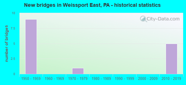
- New bridges - historical statistics
- 91950-1959
- 11970-1979
- 52010-2019


- Bridge Condition - Deck
- 40.0%Very good
- 40.0%Good
- 20.0%Satisfactory

- Bridge Condition - Superstructure
- 40.0%Very good
- 40.0%Good
- 20.0%Fair

- Bridge Condition - Channel
- 50.0%Good
- 25.0%Satisfactory
- 25.0%Fair
Find on map >> Show street view
Structure Number: 9117, Location: 1 MILE NORTH RTE 209 (Lat: 40.856397, Lng: -75.650136), Route carried "on" structure: City street , Year Built: 1970, Status: Open, Structure Length: 0.91m (2.99ft), Average Daily Traffic: 1,500 (year 1980), Truck Traffic: 1%, Average Future Daily Traffic: 2,100 (year 2000), Design Load: HS 20, Features Intersected: SAW MILL RUN, Facility Carried by Structure: T-437
Minimum Vertical Clearance: 30+ m (98+ ft), Kilometerpoint: 0.000, Lanes on structure: 2, Owner: Town or Township Highway Agency, Approaching Roadway Width: 6.1m (20.0ft), Skew: 3 degrees, Material/Design: Concrete, Design/Construction: Culvert, Number Of Spans In Main Unit: 1, Length of Maximum Span: 9.1m (29.9ft)
Condition: Channel: Fair, Culverts: Fair, Operating Rating: 49.0 metric tons, Method Used To Determine Operating Rating: Field evaluation and documented engineering judgment, Inventory Rating: 32.7 metric tons, Method Used To Determine Inventory Rating: Field evaluation and documented engineering judgment, Structural Evaluation: Somewhat better than minimum adequacy, Waterway Adequacy: Superior to present desirable criteria, Approach Roadway Alignment: Equal to present desirable criteria, Length Of Structure Improvement: 1.60m (5.25ft), Designated Inspection Frequency: Every 24 months, Inspection Date: September 2021
Find on map >> Show street view
Structure Number: 9154, Location: 0.5 MI W BELTZVILLE LAKE (Lat: 40.857203, Lng: -75.650772), Route carried "on" structure: Interstate 476, Year Built: 1956, Status: Open, Structure Length: 0.76m (2.49ft), Average Daily Traffic: 24,228 (year 2004), Truck Traffic: 20%, Average Future Daily Traffic: 32,159 (year 2030), Design Load: HS 20, Features Intersected: SAWMILL RUN
Minimum Vertical Clearance: 30+ m (98+ ft), Kilometerpoint: 0.000, Lanes on structure: 4, Base Highway Network: Yes, Toll: On toll road, Owner: State Toll Authority, Approaching Roadway Width: 21.9m (71.9ft), Skew: 35 degrees, Material/Design: Concrete, Design/Construction: Culvert, Number Of Spans In Main Unit: 1, Length of Maximum Span: 6.1m (20.0ft)
Condition: Channel: Satisfactory, Culverts: Fair, Operating Rating: 89.8 metric tons, Method Used To Determine Operating Rating: Load Factor (LF), Inventory Rating: 89.8 metric tons, Method Used To Determine Inventory Rating: Load Factor (LF), Structural Evaluation: Somewhat better than minimum adequacy, Waterway Adequacy: Superior to present desirable criteria, Approach Roadway Alignment: Equal to present desirable criteria, Length Of Structure Improvement: 1.30m (4.27ft), Designated Inspection Frequency: Every 24 months, Inspection Date: July 2021, Bridge Improvement Cost: $20,000, Roadway Improvement Cost: $60,000, Total Project Cost: $273,000
Find on map >> Show street view
Structure Number: 9155, Location: 1 MI NW BELTZVILLE LAKE (Lat: 40.862100, Lng: -75.650297), Route carried "on" structure: Interstate 476, Year Built: 1956, Status: Open, Structure Length: 1.01m (3.31ft), Average Daily Traffic: 24,228 (year 2004), Truck Traffic: 20%, Average Future Daily Traffic: 32,159 (year 2030), Design Load: HS 20, Features Intersected: T-417
Minimum Vertical Clearance: 30+ m (98+ ft), Kilometerpoint: 0.000, Lanes on structure: 4, Lanes under structure: 2, Base Highway Network: Yes, Toll: On toll road, Owner: State Toll Authority, Approaching Roadway Width: 9.1m (29.9ft), Skew: 31 degrees, Material/Design: Concrete, Design/Construction: Tee Beam, Number Of Spans In Main Unit: 1, Length of Maximum Span: 9.4m (30.8ft), Curb or Sidewalk Widths: Left: 0.2m (0.7ft), Right: 0.2m (0.7ft), Curb-To-Curb Width: 9.4m (30.8ft), Out-to-Out Width: 19.5m (64.0ft)
Condition: Deck: Good, Superstructure: Good, Substructure: Good, Operating Rating: 46.3 metric tons, Method Used To Determine Operating Rating: Allowable Stress (AS), Inventory Rating: 30.8 metric tons, Method Used To Determine Inventory Rating: Allowable Stress (AS), Structural Evaluation: Better than present minimum criteria, Deck Geometry: High priority of replacement, Underclear: High priority of corrective action, Approach Roadway Alignment: Equal to present desirable criteria, Length Of Structure Improvement: 1.60m (5.25ft), Designated Inspection Frequency: Every 24 months, Inspection Date: July 2021, Bridge Improvement Cost: $8,000, Roadway Improvement Cost: $22,000, Total Project Cost: $103,000, Deck Structure Type: Concrete Cast-file-Place, Wearing Surface/Protective System: Wearing Surface: Bituminous
Find on map >> Show street view
Structure Number: 9156, Location: 1.5 MI NW BELTZVILLE LAKE (Lat: 40.872183, Lng: -75.655422), Route carried "on" structure: Interstate 476, Year Built: 1956, Status: Open, Structure Length: 1.07m (3.51ft), Average Daily Traffic: 24,228 (year 2004), Truck Traffic: 20%, Average Future Daily Traffic: 32,159 (year 2030), Design Load: HS 20, Features Intersected: SR 2012
Minimum Vertical Clearance: 30+ m (98+ ft), Kilometerpoint: 0.000, Lanes on structure: 4, Lanes under structure: 2, Base Highway Network: Yes, Toll: On toll road, Owner: State Toll Authority, Approaching Roadway Width: 9.1m (29.9ft), Skew: 30 degrees, Material/Design: Concrete, Design/Construction: Tee Beam, Number Of Spans In Main Unit: 1, Length of Maximum Span: 9.4m (30.8ft), Curb or Sidewalk Widths: Left: 0.2m (0.7ft), Right: 0.2m (0.7ft), Curb-To-Curb Width: 9.4m (30.8ft), Out-to-Out Width: 20.9m (68.6ft)
Condition: Deck: Satisfactory, Superstructure: Fair, Substructure: Good, Operating Rating: 40.8 metric tons, Method Used To Determine Operating Rating: Load Factor (LF), Inventory Rating: 24.5 metric tons, Method Used To Determine Inventory Rating: Load Factor (LF), Structural Evaluation: Somewhat better than minimum adequacy, Deck Geometry: High priority of replacement, Underclear: High priority of corrective action, Approach Roadway Alignment: Equal to present desirable criteria, Length Of Structure Improvement: 1.70m (5.58ft), Designated Inspection Frequency: Every 24 months, Inspection Date: July 2021, Bridge Improvement Cost: $9,000, Roadway Improvement Cost: $25,000, Total Project Cost: $116,000, Deck Structure Type: Concrete Cast-file-Place, Wearing Surface/Protective System: Wearing Surface: Monolithic Concrete
Find on map >> Show street view
Structure Number: 47557, Location: HARRITY & INTERCHANGE RDS (Lat: 40.839275, Lng: -75.668119), Route carried "on" structure: State highway , Year Built: 2012, Status: Open, Structure Length: 5.06m (16.60ft), Average Daily Traffic: 5,245 (year 2022), Truck Traffic: 5%, Average Future Daily Traffic: 9,057 (year 2032), Design Load: HL 93, Features Intersected: POHOPOCO CREEK, Facility Carried by Structure: SR 2007(LR 13047)
Minimum Vertical Clearance: 30+ m (98+ ft), Kilometerpoint: 5.020, Lanes on structure: 3, Owner: State Highway Agency, Approaching Roadway Width: 14.0m (45.9ft), Material/Design: Prestressed concrete, Design/Construction: Stringer/Multi-beam, Number Of Spans In Main Unit: 1, Length of Maximum Span: 50.3m (165.0ft), Curb-To-Curb Width: 13.1m (43.0ft), Out-to-Out Width: 14.0m (45.9ft)
Condition: Deck: Very good, Superstructure: Very good, Substructure: Good, Channel: Good, Operating Rating: 71.3 metric tons, Method Used To Determine Operating Rating: Assigned ratings based on Load and Resistance Factor Design (LRFD) reported by rating factor (RF) using HL93 loadings, Inventory Rating: 34.3 metric tons, Method Used To Determine Inventory Rating: Assigned ratings based on Load and Resistance Factor Design (LRFD) reported by rating factor (RF) using HL93 loadings, Structural Evaluation: Better than present minimum criteria, Deck Geometry: Meets minimum limits, Waterway Adequacy: Equal to present desirable criteria, Approach Roadway Alignment: Equal to present desirable criteria, Designated Inspection Frequency: Every 48 months, Inspection Date: October 2018, Deck Structure Type: Concrete Cast-file-Place, Wearing Surface/Protective System: Wearing Surface: Monolithic Concrete, Deck Protection: Epoxy Coated Reinforcing
Find on map >> Show street view
Structure Number: 52497, Location: Mahoning Valley insection (Lat: 40.839458, Lng: -75.666669), Route carried "on" structure: Interstate 476, Year Built: 2014, Status: Open, Structure Length: 11.98m (39.30ft), Average Daily Traffic: 22,198 (year 2001), Truck Traffic: 22%, Average Future Daily Traffic: 30,443 (year 2030), Design Load: HL 93, Features Intersected: SR 0209, LR164
Minimum Vertical Clearance: 30+ m (98+ ft), Kilometerpoint: 0.000, Lanes on structure: 4, Lanes under structure: 5, Base Highway Network: Yes, Toll: On toll road, Owner: State Toll Authority, Approaching Roadway Width: 27.4m (89.9ft), Skew: 33 degrees, Material/Design: Prestressed concrete continuous, Design/Construction: Stringer/Multi-beam, Number Of Spans In Main Unit: 3, Length of Maximum Span: 39.9m (130.9ft), Curb-To-Curb Width: 11.0m (36.1ft), Out-to-Out Width: 28.6m (93.8ft)
Condition: Deck: Very good, Superstructure: Good, Substructure: Good, Channel: Good, Operating Rating: 47.3 metric tons, Method Used To Determine Operating Rating: Assigned ratings based on Load and Resistance Factor Design (LRFD) reported by rating factor (RF) using HL93 loadings, Inventory Rating: 36.6 metric tons, Method Used To Determine Inventory Rating: Assigned ratings based on Load and Resistance Factor Design (LRFD) reported by rating factor (RF) using HL93 loadings, Structural Evaluation: Better than present minimum criteria, Deck Geometry: High priority of replacement, Underclear: Equal to present minimum criteria, Waterway Adequacy: Superior to present desirable criteria, Approach Roadway Alignment: Equal to present desirable criteria, Designated Inspection Frequency: Every 48 months, Inspection Date: August 2019, Deck Structure Type: Concrete Cast-file-Place, Wearing Surface/Protective System: Wearing Surface: Integral Concrete, Deck Protection: Epoxy Coated Reinforcing
Find on map >> Show street view
Structure Number: 52506, Location: Mahoning Valley Interch. (Lat: 40.840050, Lng: -75.665817), Route carried "on" structure: Interstate 476, Year Built: 2015, Status: Open, Structure Length: 2.56m (8.40ft), Average Daily Traffic: 22,198 (year 2001), Truck Traffic: 22%, Average Future Daily Traffic: 30,443 (year 2030), Design Load: HL 93, Features Intersected: T-437 (Pohopoco Dr.)
Minimum Vertical Clearance: 30+ m (98+ ft), Kilometerpoint: 0.000, Lanes on structure: 4, Lanes under structure: 2, Base Highway Network: Yes, Toll: On toll road, Owner: State Toll Authority, Approaching Roadway Width: 27.4m (89.9ft), Skew: 33 degrees, Material/Design: Prestressed concrete, Design/Construction: Stringer/Multi-beam, Number Of Spans In Main Unit: 1, Length of Maximum Span: 24.7m (81.0ft), Curb or Sidewalk Widths: Left: 0.2m (0.7ft), Right: 0.2m (0.7ft), Curb-To-Curb Width: 27.0m (88.6ft), Out-to-Out Width: 28.6m (93.8ft)
Condition: Deck: Good, Superstructure: Very good, Substructure: Good, Operating Rating: 52.2 metric tons, Method Used To Determine Operating Rating: Assigned ratings based on Load and Resistance Factor Design (LRFD) reported by rating factor (RF) using HL93 loadings, Inventory Rating: 38.9 metric tons, Method Used To Determine Inventory Rating: Assigned ratings based on Load and Resistance Factor Design (LRFD) reported by rating factor (RF) using HL93 loadings, Structural Evaluation: Better than present minimum criteria, Deck Geometry: Superior to present desirable criteria, Underclear: Better than present minimum criteria, Approach Roadway Alignment: Equal to present desirable criteria, Designated Inspection Frequency: Every 24 months, Inspection Date: June 2021, Deck Structure Type: Concrete Cast-file-Place, Wearing Surface/Protective System: Wearing Surface: Monolithic Concrete, Deck Protection: Epoxy Coated Reinforcing
Find on map >> Show street view
Structure Number: 9, Location: MAHONING INTERCHANGE (Lat: 40.838225, Lng: -75.668553), Route carried "under" structure: US 209, Year Built: 1956, Structure Length: 0. m, Average Daily Traffic: 6,029 (year 2020), Truck Traffic: 7%, Features Intersected: SR 0209, LR 164, Facility Carried by Structure: PA TPK (RAMP G)
Minimum Vertical Clearance: 4.65m (15.26ft), Kilometerpoint: 25.815, Lanes on structure: 2, Lanes under structure: 4, Material/Design: Steel, Design/Construction: Stringer/Multi-beam, Length of Maximum Span: 26.5m (86.9ft)
Find on map >> Show street view
Structure Number: 9, Location: MAHONING INTERCHANGE (Lat: 40.838225, Lng: -75.668553), Route carried "under" structure: US 209, Year Built: 1956, Structure Length: 0. m, Average Daily Traffic: 6,171 (year 2020), Truck Traffic: 6%, Features Intersected: SR 0209, LR 164, Facility Carried by Structure: PA TPK (RAMP G)
Minimum Vertical Clearance: 5.21m (17.09ft), Kilometerpoint: 25.822, Lanes on structure: 2, Lanes under structure: 4, Material/Design: Steel, Design/Construction: Stringer/Multi-beam, Length of Maximum Span: 26.5m (86.9ft)
Find on map >> Show street view
Structure Number: 915, Location: MAHONING VALLEY INTERCH. (Lat: 40.835453, Lng: -75.672594), Route carried "under" structure: Interstate 476, Year Built: 1956, Structure Length: 0. m, Average Daily Traffic: 24,228 (year 2004), Truck Traffic: 20%, Features Intersected: PA TPK (I-476), Facility Carried by Structure: PA TPK RAMP AB
Minimum Vertical Clearance: 4.57m (14.99ft), Kilometerpoint: 0.000, Lanes on structure: 2, Lanes under structure: 5, Toll: On toll road, Material/Design: Steel, Design/Construction: Stringer/Multi-beam, Length of Maximum Span: 34.4m (112.9ft)
Find on map >> Show street view
Structure Number: 9153, Location: 1 MI-W OF BELTZVILLE LAKE (Lat: 40.851922, Lng: -75.654847), Route carried "under" structure: Interstate 476, Year Built: 1956, Structure Length: 0. m, Average Daily Traffic: 24,228 (year 2004), Truck Traffic: 20%, Features Intersected: PA TPK (I-476), Facility Carried by Structure: T-444
Minimum Vertical Clearance: 4.57m (14.99ft), Kilometerpoint: 0.000, Lanes on structure: 2, Lanes under structure: 4, Material/Design: Steel, Design/Construction: Stringer/Multi-beam, Length of Maximum Span: 24.7m (81.0ft)
Find on map >> Show street view
Structure Number: 9155, Location: 1 MI NW BELTZVILLE LAKE (Lat: 40.862100, Lng: -75.650297), Route carried "under" structure: City street , Year Built: 1956, Structure Length: 0. m, Average Daily Traffic: 200 (year 1992), Features Intersected: T-417, Facility Carried by Structure: PA TPK (I-476)
Minimum Vertical Clearance: 4.40m (14.44ft), Kilometerpoint: 0.000, Lanes on structure: 4, Lanes under structure: 2, Toll: On toll road, Material/Design: Concrete, Design/Construction: Tee Beam, Length of Maximum Span: 9.4m (30.8ft)
Find on map >> Show street view
Structure Number: 9156, Location: 1.5 MI NW BELTZVILLE LAKE (Lat: 40.872183, Lng: -75.655422), Route carried "under" structure: State highway , Year Built: 1956, Structure Length: 0. m, Average Daily Traffic: 1,147 (year 2021), Truck Traffic: 6%, Features Intersected: SR 2012, Facility Carried by Structure: PA TPK (I-476)
Minimum Vertical Clearance: 5.82m (19.09ft), Kilometerpoint: 0.000, Lanes on structure: 4, Lanes under structure: 2, Material/Design: Concrete, Design/Construction: Tee Beam, Length of Maximum Span: 9.4m (30.8ft)
Find on map >> Show street view
Structure Number: 52497, Location: Mahoning Valley insection (Lat: 40.839458, Lng: -75.666669), Route carried "under" structure: US 209, Year Built: 2014, Structure Length: 0. m, Average Daily Traffic: 3,511 (year 2020), Truck Traffic: 7%, Features Intersected: SR 0209, LR164, Facility Carried by Structure: PA TPK (I-476)
Minimum Vertical Clearance: 30+ m (98+ ft), Kilometerpoint: 25.822, Lanes on structure: 4, Lanes under structure: 2, Material/Design: Prestressed concrete continuous, Design/Construction: Stringer/Multi-beam, Length of Maximum Span: 39.9m (130.9ft)
Find on map >> Show street view
Structure Number: 52497, Location: Mahoning Valley insection (Lat: 40.839458, Lng: -75.666669), Route carried "under" structure: US 209, Year Built: 2014, Structure Length: 0. m, Average Daily Traffic: 3,647 (year 2020), Truck Traffic: 7%, Features Intersected: SR 0209, LR164, Facility Carried by Structure: PA TPK (I-476)
Minimum Vertical Clearance: 5.17m (16.96ft), Kilometerpoint: 25.815, Lanes on structure: 4, Lanes under structure: 3, Material/Design: Prestressed concrete continuous, Design/Construction: Stringer/Multi-beam, Length of Maximum Span: 39.9m (130.9ft)