Bridge Statistics for Webberville, Michigan (MI)
Condition, Traffic, Stress, Structural Evaluation, Project Costs
- National Bridge Inventory (NBI) Statistics
- 25Number of bridges
- 190ft / 58.1mTotal length
- $416,000Total costs
- 298,917Total average daily traffic
- 30,687Total average daily truck traffic
- National Bridge Inventory (NBI) Registered Bridges for Webberville
- No street view available for this location
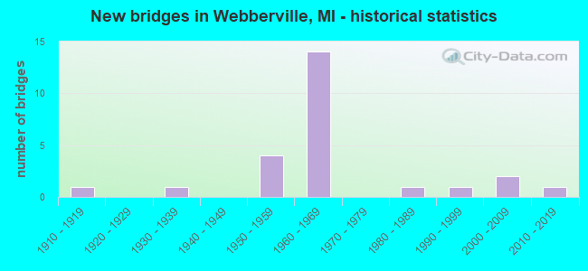
- New bridges - historical statistics
- 11910-1919
- 11930-1939
- 41950-1959
- 141960-1969
- 11980-1989
- 11990-1999
- 22000-2009
- 12010-2019

- Reconstructed bridges - Historical Statistics
- 11960-1969
- 01970-1979
- 01980-1989
- 01990-1999
- 22000-2009


- Bridge Condition - Deck
- 5.6%Very good
- 22.2%Good
- 50.0%Satisfactory
- 16.7%Fair
- 5.6%Serious

- Bridge Condition - Superstructure
- 5.6%Excellent
- 5.6%Very good
- 27.8%Good
- 33.3%Satisfactory
- 22.2%Fair
- 5.6%Serious

- Bridge Condition - Substructure
- 22.2%Very good
- 33.3%Good
- 22.2%Satisfactory
- 16.7%Fair
- 5.6%Serious

- Bridge Condition - Channel
- 26.7%Good
- 46.7%Satisfactory
- 20.0%Fair
- 6.7%Serious

- Bridge Condition - Culverts
- 50.0%Good
- 50.0%Satisfactory
Find on map >> Show street view
Structure Number: 3787, Location: 0.6 MI N OF M-43 (Lat: 42.683083, Lng: -84.219536), Route carried "on" structure: State highway 52, Year Built: 1952, Status: Open, Structure Length: 3.66m (12.01ft), Average Daily Traffic: 5,484 (year 2007), Truck Traffic: 6%, Average Future Daily Traffic: 5,505 (year 2018), Design Load: HS 20, Features Intersected: RED CEDAR RIVER
Minimum Vertical Clearance: 30.48m (100.00ft), Kilometerpoint: 0.763, Lanes on structure: 2, Base Highway Network: Yes (Inventory Route: 36, Subroute: 4), Owner: State Highway Agency, Approaching Roadway Width: 12.5m (41.0ft), Skew: 4 degrees, Material/Design: Steel, Design/Construction: Stringer/Multi-beam, Number Of Spans In Main Unit: 2, Length of Maximum Span: 18.3m (60.0ft), Curb-To-Curb Width: 12.2m (40.0ft), Out-to-Out Width: 13.2m (43.3ft)
Condition: Deck: Satisfactory, Superstructure: Satisfactory, Substructure: Satisfactory, Channel: Satisfactory, Operating Rating: 67.4 metric tons, Method Used To Determine Operating Rating: Load Factor (LF) rating reported by rating factor (RF) method using MS18 loading, Inventory Rating: 40.5 metric tons, Method Used To Determine Inventory Rating: Load Factor (LF) rating reported by rating factor (RF) method using MS18 loading, Structural Evaluation: Equal to present minimum criteria, Deck Geometry: Somewhat better than minimum adequacy, Waterway Adequacy: Equal to present minimum criteria, Approach Roadway Alignment: Equal to present desirable criteria, Designated Inspection Frequency: Every 24 months, Inspection Date: July 2020, Deck Structure Type: Concrete Cast-file-Place, Wearing Surface/Protective System: Wearing Surface: Epoxy Overlay, Deck Protection: Epoxy Coated Reinforcing
Find on map >> Show street view
Structure Number: 3833, Location: 1.6 MI W OF M-43 & M-52 (Lat: 42.666003, Lng: -84.228206), Route carried "on" structure: County highway , Year Built: 1961, Status: Open, Structure Length: 6.49m (21.29ft), Average Daily Traffic: 950 (year 1996), Truck Traffic: 3%, Average Future Daily Traffic: 1,093 (year 2016), Design Load: H 15, Features Intersected: I-96, Facility Carried by Structure: DIETZ RD
Minimum Vertical Clearance: 30.48m (100.00ft), Kilometerpoint: 16.511, Lanes on structure: 2, Lanes under structure: 4, Owner: State Highway Agency, Approaching Roadway Width: 11.2m (36.7ft), Material/Design: Prestressed concrete, Design/Construction: Stringer/Multi-beam, Number Of Spans In Main Unit: 4, Length of Maximum Span: 21.2m (69.6ft), Curb-To-Curb Width: 8.5m (27.9ft), Out-to-Out Width: 9.4m (30.8ft)
Condition: Deck: Satisfactory, Superstructure: Fair, Substructure: Satisfactory, Operating Rating: 63.5 metric tons, Method Used To Determine Operating Rating: Load Factor (LF) rating reported by rating factor (RF) method using MS18 loading, Inventory Rating: 32.7 metric tons, Method Used To Determine Inventory Rating: Load Factor (LF) rating reported by rating factor (RF) method using MS18 loading, Structural Evaluation: Somewhat better than minimum adequacy, Deck Geometry: Somewhat better than minimum adequacy, Underclear: Meets minimum limits, Approach Roadway Alignment: Equal to present minimum criteria, Designated Inspection Frequency: Every 21 months, Inspection Date: December 2020, Deck Structure Type: Concrete Cast-file-Place, Wearing Surface/Protective System: Wearing Surface: Monolithic Concrete
Find on map >> Show street view
Structure Number: 3837, Location: 1 MI EAST OF M-52 (Lat: 42.652231, Lng: -84.179586), Route carried "on" structure: Interstate 96, Year Built: 1962, Status: Open, Structure Length: 0.70m (2.30ft), Average Daily Traffic: 48,560 (year 2007), Truck Traffic: 11%, Average Future Daily Traffic: 64,758 (year 2018), Design Load: HS 20+Mod, Features Intersected: KALAMINK CREEK
Minimum Vertical Clearance: 30.48m (100.00ft), Kilometerpoint: 35.820, Lanes on structure: 4, Base Highway Network: Yes (Inventory Route: 33, Subroute: 4), Owner: State Highway Agency, Approaching Roadway Width: 11.0m (36.1ft), Material/Design: Concrete, Design/Construction: Culvert, Number Of Spans In Main Unit: 2, Length of Maximum Span: 3.3m (10.8ft), Curb-To-Curb Width: 11.0m (36.1ft), Out-to-Out Width: 57.3m (188.0ft)
Condition: Channel: Fair, Culverts: Satisfactory, Operating Rating: 97.2 metric tons, Method Used To Determine Operating Rating: Load Factor (LF) rating reported by rating factor (RF) method using MS18 loading, Inventory Rating: 79.1 metric tons, Method Used To Determine Inventory Rating: Load Factor (LF) rating reported by rating factor (RF) method using MS18 loading, Structural Evaluation: Equal to present minimum criteria, Deck Geometry: High priority of replacement, Waterway Adequacy: Equal to present minimum criteria, Approach Roadway Alignment: Equal to present desirable criteria, Designated Inspection Frequency: Every 24 months, Inspection Date: September 2020, Wearing Surface/Protective System: Wearing Surface: Bituminous
Find on map >> Show street view
Structure Number: 3838, Location: @ M-52 (STOCKBRIDGE RD) (Lat: 42.658764, Lng: -84.198097), Route carried "on" structure: Interstate 96, Year Built: 1962, Status: Open, Structure Length: 5.12m (16.80ft), Average Daily Traffic: 23,638 (year 2018), Truck Traffic: 12%, Average Future Daily Traffic: 27,184 (year 2038), Design Load: HS 20+Mod, Features Intersected: M-52 & M-43
Minimum Vertical Clearance: 30.48m (100.00ft), Kilometerpoint: 34.102, Lanes on structure: 2, Lanes under structure: 4, Base Highway Network: Yes (Inventory Route: 33, Subroute: 4), Owner: State Highway Agency, Approaching Roadway Width: 13.1m (43.0ft), Skew: 3 degrees, Material/Design: Steel, Design/Construction: Stringer/Multi-beam, Number Of Spans In Main Unit: 3, Length of Maximum Span: 25.2m (82.7ft), Curb-To-Curb Width: 11.7m (38.4ft), Out-to-Out Width: 13.3m (43.6ft)
Condition: Deck: Satisfactory, Superstructure: Fair, Substructure: Good, Operating Rating: 64.8 metric tons, Method Used To Determine Operating Rating: Load Factor (LF) rating reported by rating factor (RF) method using MS18 loading, Inventory Rating: 38.6 metric tons, Method Used To Determine Inventory Rating: Load Factor (LF) rating reported by rating factor (RF) method using MS18 loading, Structural Evaluation: Somewhat better than minimum adequacy, Deck Geometry: Equal to present minimum criteria, Underclear: Meets minimum limits, Approach Roadway Alignment: Equal to present desirable criteria, Designated Inspection Frequency: Every 24 months, Inspection Date: September 2020, Deck Structure Type: Concrete Cast-file-Place, Wearing Surface/Protective System: Wearing Surface: Latex Concrete
Find on map >> Show street view
Structure Number: 3839, Location: @ M-52 (STOCKBRIDGE RD) (Lat: 42.659433, Lng: -84.198117), Route carried "on" structure: Interstate 96, Year Built: 1962, Status: Open, Structure Length: 5.12m (16.80ft), Average Daily Traffic: 23,638 (year 2018), Truck Traffic: 12%, Average Future Daily Traffic: 27,184 (year 2038), Design Load: HS 20+Mod, Features Intersected: M-52 & M-43
Minimum Vertical Clearance: 30.48m (100.00ft), Kilometerpoint: 34.106, Lanes on structure: 2, Lanes under structure: 4, Base Highway Network: Yes (Inventory Route: 33, Subroute: 10), Owner: State Highway Agency, Approaching Roadway Width: 12.8m (42.0ft), Skew: 3 degrees, Material/Design: Steel, Design/Construction: Stringer/Multi-beam, Number Of Spans In Main Unit: 3, Length of Maximum Span: 25.2m (82.7ft), Curb-To-Curb Width: 11.7m (38.4ft), Out-to-Out Width: 13.3m (43.6ft)
Condition: Deck: Satisfactory, Superstructure: Fair, Substructure: Fair, Operating Rating: 63.5 metric tons, Method Used To Determine Operating Rating: Load Factor (LF) rating reported by rating factor (RF) method using MS18 loading, Inventory Rating: 37.9 metric tons, Method Used To Determine Inventory Rating: Load Factor (LF) rating reported by rating factor (RF) method using MS18 loading, Structural Evaluation: Somewhat better than minimum adequacy, Deck Geometry: Equal to present minimum criteria, Underclear: Meets minimum limits, Approach Roadway Alignment: Equal to present desirable criteria, Designated Inspection Frequency: Every 24 months, Inspection Date: September 2020, Deck Structure Type: Concrete Cast-file-Place, Wearing Surface/Protective System: Wearing Surface: Latex Concrete
Find on map >> Show street view
Structure Number: 384, Location: 1.2 MI E OF M-52 (Lat: 42.651853, Lng: -84.177992), Route carried "on" structure: County highway , Year Built: 1962, Status: Open, Structure Length: 6.62m (21.72ft), Average Daily Traffic: 1,250 (year 2018), Truck Traffic: 1%, Average Future Daily Traffic: 1,438 (year 2038), Design Load: H 15, Features Intersected: I-96, Facility Carried by Structure: ELM RD
Minimum Vertical Clearance: 30.48m (100.00ft), Kilometerpoint: 2.522, Lanes on structure: 2, Lanes under structure: 4, Owner: State Highway Agency, Approaching Roadway Width: 11.5m (37.7ft), Material/Design: Prestressed concrete, Design/Construction: Stringer/Multi-beam, Number Of Spans In Main Unit: 4, Length of Maximum Span: 21.2m (69.6ft), Curb-To-Curb Width: 8.5m (27.9ft), Out-to-Out Width: 9.4m (30.8ft)
Condition: Deck: Satisfactory, Superstructure: Satisfactory, Substructure: Good, Operating Rating: 52.5 metric tons, Method Used To Determine Operating Rating: Load Factor (LF) rating reported by rating factor (RF) method using MS18 loading, Inventory Rating: 31.4 metric tons, Method Used To Determine Inventory Rating: Load Factor (LF) rating reported by rating factor (RF) method using MS18 loading, Structural Evaluation: Equal to present minimum criteria, Deck Geometry: Somewhat better than minimum adequacy, Underclear: High priority of corrective action, Approach Roadway Alignment: Equal to present desirable criteria, Designated Inspection Frequency: Every 24 months, Inspection Date: September 2020, Deck Structure Type: Concrete Cast-file-Place, Wearing Surface/Protective System: Wearing Surface: Latex Concrete, Deck Protection: Epoxy Coated Reinforcing
Find on map >> Show street view
Structure Number: 3841, Location: @ LIVINGSTON CO LINE (Lat: 42.650869, Lng: -84.148261), Route carried "on" structure: County highway , Year Built: 1962, Status: Open, Structure Length: 9.75m (31.99ft), Average Daily Traffic: 1,250 (year 2018), Truck Traffic: 1%, Average Future Daily Traffic: 1,438 (year 2038), Design Load: H 15, Features Intersected: I-96, Facility Carried by Structure: WALLACE RD
Minimum Vertical Clearance: 30.48m (100.00ft), Kilometerpoint: 1.679, Lanes on structure: 2, Lanes under structure: 4, Owner: State Highway Agency, Approaching Roadway Width: 11.5m (37.7ft), Material/Design: Prestressed concrete, Design/Construction: Stringer/Multi-beam, Number Of Spans In Main Unit: 6, Length of Maximum Span: 19.8m (65.0ft), Curb-To-Curb Width: 8.5m (27.9ft), Out-to-Out Width: 9.4m (30.8ft)
Condition: Deck: Satisfactory, Superstructure: Satisfactory, Substructure: Good, Operating Rating: 53.8 metric tons, Method Used To Determine Operating Rating: Load Factor (LF) rating reported by rating factor (RF) method using MS18 loading, Inventory Rating: 23.7 metric tons, Method Used To Determine Inventory Rating: Load Factor (LF) rating reported by rating factor (RF) method using MS18 loading, Structural Evaluation: Equal to present minimum criteria, Deck Geometry: Somewhat better than minimum adequacy, Underclear: High priority of corrective action, Approach Roadway Alignment: Equal to present desirable criteria, Designated Inspection Frequency: Every 22 months, Inspection Date: November 2020, Deck Structure Type: Concrete Cast-file-Place, Wearing Surface/Protective System: Wearing Surface: Latex Concrete, Deck Protection: Epoxy Coated Reinforcing
Find on map >> Show street view
Structure Number: 3883, Location: 0.8 MILES N OF M-43 (Lat: 42.686878, Lng: -84.229311), Route carried "on" structure: County highway , Year Built: 1934, Status: Closed, Structure Length: 1.58m (5.18ft), Average Daily Traffic: 680 (year 2002), Average Future Daily Traffic: 880 (year 2027), Design Load: H 20, Features Intersected: RED CEDAR RIVER, Facility Carried by Structure: DIETZ ROAD
Minimum Vertical Clearance: 30.48m (100.00ft), Kilometerpoint: 18.830, Lanes on structure: 2, Owner: County Highway Agency, Approaching Roadway Width: 10.4m (34.1ft), Skew: 3 degrees, Material/Design: Steel, Design/Construction: Stringer/Multi-beam, Number Of Spans In Main Unit: 1, Length of Maximum Span: 15.8m (51.8ft), Curb or Sidewalk Widths: Left: 0.5m (1.6ft), Right: 0.5m (1.6ft), Curb-To-Curb Width: 7.3m (24.0ft), Out-to-Out Width: 8.5m (27.9ft)
Condition: Deck: Serious, Superstructure: Serious, Substructure: Satisfactory, Channel: Good, Deck Geometry: Meets minimum limits, Waterway Adequacy: Equal to present minimum criteria, Approach Roadway Alignment: Equal to present desirable criteria, Bridge Posting: Required (Relationship of Operating Rating to Maximum Legal Load: > 39.9% below), Length Of Structure Improvement: 1.58m (5.18ft), Designated Inspection Frequency: Every 24 months, Inspection Date: June 2020, Bridge Improvement Cost: $158,000, Roadway Improvement Cost: $24,000, Total Project Cost: $182,000, Deck Structure Type: Concrete Cast-file-Place, Wearing Surface/Protective System: Wearing Surface: Bituminous
Find on map >> Show street view
Structure Number: 3884, Location: 2 MI NW OF WEBBERVILLE (Lat: 42.681536, Lng: -84.189561), Route carried "on" structure: County highway , Year Built: 1955, Year Reconstructed: 2013, Status: Open, Structure Length: 3.66m (12.01ft), Average Daily Traffic: 1,605 (year 2013), Average Future Daily Traffic: 1,963 (year 2033), Design Load: H 20, Features Intersected: RED CEDAR RIVER, Facility Carried by Structure: WEBBERVILLE ROAD
Minimum Vertical Clearance: 30.48m (100.00ft), Kilometerpoint: 1.833, Lanes on structure: 2, Owner: County Highway Agency, Approaching Roadway Width: 9.1m (29.9ft), Skew: 2 degrees, Material/Design: Steel continuous, Design/Construction: Stringer/Multi-beam, Number Of Spans In Main Unit: 3, Length of Maximum Span: 15.2m (49.9ft), Curb-To-Curb Width: 9.1m (29.9ft), Out-to-Out Width: 9.9m (32.5ft)
Condition: Deck: Satisfactory, Superstructure: Good, Substructure: Good, Channel: Satisfactory, Operating Rating: 59.6 metric tons, Method Used To Determine Operating Rating: Load Factor (LF) rating reported by rating factor (RF) method using MS18 loading, Inventory Rating: 35.6 metric tons, Method Used To Determine Inventory Rating: Load Factor (LF) rating reported by rating factor (RF) method using MS18 loading, Structural Evaluation: Better than present minimum criteria, Deck Geometry: Somewhat better than minimum adequacy, Waterway Adequacy: Equal to present desirable criteria, Approach Roadway Alignment: Equal to present desirable criteria, Designated Inspection Frequency: Every 24 months, Inspection Date: October 2021, Deck Structure Type: Concrete Cast-file-Place, Wearing Surface/Protective System: Wearing Surface: Latex Concrete
Find on map >> Show street view
Structure Number: 3885, Location: 2 MI NE OF WEBBERVILLE (Lat: 42.684628, Lng: -84.166483), Route carried "on" structure: County highway , Year Built: 1954, Year Reconstructed: 2013, Status: Posted for load, Structure Length: 3.66m (12.01ft), Average Daily Traffic: 1,851 (year 2013), Average Future Daily Traffic: 2,751 (year 2033), Features Intersected: RED CEDAR RIVER, Facility Carried by Structure: GRAMER ROAD
Minimum Vertical Clearance: 30.48m (100.00ft), Kilometerpoint: 3.682, Lanes on structure: 2, Owner: County Highway Agency, Approaching Roadway Width: 9.1m (29.9ft), Skew: 3 degrees, Material/Design: Steel continuous, Design/Construction: Stringer/Multi-beam, Number Of Spans In Main Unit: 3, Length of Maximum Span: 14.0m (45.9ft), Curb-To-Curb Width: 9.1m (29.9ft), Out-to-Out Width: 9.9m (32.5ft)
Condition: Deck: Good, Superstructure: Good, Substructure: Satisfactory, Channel: Fair, Operating Rating: 38.2 metric tons, Method Used To Determine Operating Rating: Load Factor (LF) rating reported by rating factor (RF) method using MS18 loading, Inventory Rating: 23.0 metric tons, Method Used To Determine Inventory Rating: Load Factor (LF) rating reported by rating factor (RF) method using MS18 loading, Structural Evaluation: Equal to present minimum criteria, Deck Geometry: Somewhat better than minimum adequacy, Waterway Adequacy: Equal to present desirable criteria, Approach Roadway Alignment: Equal to present minimum criteria, Bridge Posting: Required (Relationship of Operating Rating to Maximum Legal Load: 10.0 - 19.9% below), Designated Inspection Frequency: Every 24 months, Inspection Date: October 2021, Deck Structure Type: Concrete Cast-file-Place, Wearing Surface/Protective System: Wearing Surface: Latex Concrete
Find on map >> Show street view
Structure Number: 3898, Location: 3.8 MI SE OF WEBBERVILLE (Lat: 42.614081, Lng: -84.148203), Route carried "on" structure: County highway , Year Built: 1984, Status: Posted for load, Structure Length: 0.97m (3.18ft), Average Daily Traffic: 250 (year 2019), Average Future Daily Traffic: 310 (year 2039), Design Load: HS 20, Features Intersected: WEST CEDAR DRAIN, Facility Carried by Structure: DENNIS ROAD
Minimum Vertical Clearance: 30.48m (100.00ft), Kilometerpoint: 9.186, Lanes on structure: 2, Owner: County Highway Agency, Approaching Roadway Width: 7.6m (24.9ft), Material/Design: Prestressed concrete, Design/Construction: Box Beam or Girders - Multiple, Number Of Spans In Main Unit: 1, Length of Maximum Span: 9.7m (31.8ft), Curb-To-Curb Width: 7.3m (24.0ft), Out-to-Out Width: 7.4m (24.3ft)
Condition: Deck: Fair, Superstructure: Fair, Substructure: Serious, Channel: Serious, Operating Rating: 11.8 metric tons, Method Used To Determine Operating Rating: Field evaluation and documented engineering judgment, Inventory Rating: 7.1 metric tons, Method Used To Determine Inventory Rating: Field evaluation and documented engineering judgment, Structural Evaluation: High priority of corrective action, Deck Geometry: Somewhat better than minimum adequacy, Waterway Adequacy: High priority of corrective action, Approach Roadway Alignment: Equal to present desirable criteria, Bridge Posting: Required (Relationship of Operating Rating to Maximum Legal Load: > 39.9% below), Length Of Structure Improvement: 0.98m (3.22ft), Designated Inspection Frequency: Every 12 months, Inspection Date: June 2021, Bridge Improvement Cost: $131,000, Roadway Improvement Cost: $19,000, Total Project Cost: $150,000, Deck Structure Type: Concrete Precast Panels, Wearing Surface/Protective System: Wearing Surface: Bituminous
Find on map >> Show street view
Structure Number: 3902, Location: 4.4 MI SE OF WEBBERVILLE (Lat: 42.605897, Lng: -84.145361), Route carried "on" structure: County highway , Year Built: 2002, Status: Open, Structure Length: 0.98m (3.22ft), Average Daily Traffic: 220 (year 2019), Average Future Daily Traffic: 270 (year 2039), Design Load: HS 20, Features Intersected: WEST CEDAR DRAIN, Facility Carried by Structure: KANE ROAD
Minimum Vertical Clearance: 30.48m (100.00ft), Kilometerpoint: 12.840, Lanes on structure: 2, Owner: County Highway Agency, Approaching Roadway Width: 6.7m (22.0ft), Skew: 2 degrees, Material/Design: Concrete, Design/Construction: Culvert, Number Of Spans In Main Unit: 1, Length of Maximum Span: 9.8m (32.2ft), Out-to-Out Width: 20.4m (66.9ft)
Condition: Channel: Good, Culverts: Good, Operating Rating: 43.6 metric tons, Method Used To Determine Operating Rating: Field evaluation and documented engineering judgment, Inventory Rating: 32.7 metric tons, Method Used To Determine Inventory Rating: Field evaluation and documented engineering judgment, Structural Evaluation: Better than present minimum criteria, Waterway Adequacy: Equal to present desirable criteria, Approach Roadway Alignment: Equal to present desirable criteria, Length Of Structure Improvement: 0.98m (3.22ft), Designated Inspection Frequency: Every 24 months, Inspection Date: June 2021, Bridge Improvement Cost: $5,000, Total Project Cost: $5,000
Find on map >> Show street view
Structure Number: 3905, Location: 1.4 MI NE OF WEBBERVILLE (Lat: 42.685625, Lng: -84.185303), Route carried "on" structure: County highway , Year Built: 1968, Status: Posted for load, Structure Length: 0.82m (2.69ft), Average Daily Traffic: 1,400 (year 2019), Truck Traffic: 2%, Average Future Daily Traffic: 1,700 (year 2039), Design Load: H 20, Features Intersected: WOLF CREEK, Facility Carried by Structure: ALLEN ROAD
Minimum Vertical Clearance: 30.48m (100.00ft), Kilometerpoint: 0.369, Lanes on structure: 2, Owner: County Highway Agency, Approaching Roadway Width: 8.5m (27.9ft), Material/Design: Steel, Design/Construction: Stringer/Multi-beam, Number Of Spans In Main Unit: 1, Length of Maximum Span: 8.2m (26.9ft), Curb-To-Curb Width: 6.7m (22.0ft), Out-to-Out Width: 7.2m (23.6ft)
Condition: Deck: Fair, Superstructure: Satisfactory, Substructure: Fair, Channel: Satisfactory, Operating Rating: 32.1 metric tons, Method Used To Determine Operating Rating: Load Factor (LF) rating reported by rating factor (RF) method using MS18 loading, Inventory Rating: 19.1 metric tons, Method Used To Determine Inventory Rating: Load Factor (LF) rating reported by rating factor (RF) method using MS18 loading, Structural Evaluation: Somewhat better than minimum adequacy, Deck Geometry: High priority of corrective action, Waterway Adequacy: Equal to present minimum criteria, Approach Roadway Alignment: Equal to present desirable criteria, Bridge Posting: Required (Relationship of Operating Rating to Maximum Legal Load: > 39.9% below), Length Of Structure Improvement: 0.82m (2.69ft), Designated Inspection Frequency: Every 24 months, Inspection Date: June 2021, Bridge Improvement Cost: $20,000, Roadway Improvement Cost: $19,000, Total Project Cost: $39,000, Deck Structure Type: Concrete Cast-file-Place, Wearing Surface/Protective System: Wearing Surface: Bituminous
Find on map >> Show street view
Structure Number: 3907, Location: 0.6 MI NE OF BELL OAK (Lat: 42.735803, Lng: -84.174961), Route carried "on" structure: County highway , Year Built: 1910, Year Reconstructed: 1969, Status: Open, Structure Length: 0.79m (2.59ft), Average Daily Traffic: 50 (year 2019), Truck Traffic: 2%, Average Future Daily Traffic: 70 (year 2039), Design Load: H 20, Features Intersected: WOLF CREEK, Facility Carried by Structure: HOXIE ROAD
Minimum Vertical Clearance: 30.48m (100.00ft), Kilometerpoint: 0.713, Lanes on structure: 2, Owner: County Highway Agency, Approaching Roadway Width: 7.9m (25.9ft), Material/Design: Steel, Design/Construction: Stringer/Multi-beam, Number Of Spans In Main Unit: 1, Length of Maximum Span: 7.9m (25.9ft), Curb-To-Curb Width: 6.4m (21.0ft), Out-to-Out Width: 7.2m (23.6ft)
Condition: Deck: Satisfactory, Superstructure: Satisfactory, Substructure: Fair, Channel: Satisfactory, Operating Rating: 65.8 metric tons, Method Used To Determine Operating Rating: Load Factor (LF) rating reported by rating factor (RF) method using MS18 loading, Inventory Rating: 39.2 metric tons, Method Used To Determine Inventory Rating: Load Factor (LF) rating reported by rating factor (RF) method using MS18 loading, Structural Evaluation: Somewhat better than minimum adequacy, Deck Geometry: Somewhat better than minimum adequacy, Waterway Adequacy: Equal to present desirable criteria, Approach Roadway Alignment: Equal to present desirable criteria, Designated Inspection Frequency: Every 24 months, Inspection Date: June 2021, Bridge Improvement Cost: $21,000, Roadway Improvement Cost: $19,000, Total Project Cost: $40,000, Deck Structure Type: Concrete Cast-file-Place, Wearing Surface/Protective System: Wearing Surface: Monolithic Concrete
Find on map >> Show street view
Structure Number: 5791, Location: 0.2 MI E OF INGHAM COL (Lat: 42.650789, Lng: -84.143050), Route carried "on" structure: Interstate 96, Year Built: 1961, Status: Open, Structure Length: 1.22m (4.00ft), Average Daily Traffic: 24,280 (year 2007), Truck Traffic: 11%, Average Future Daily Traffic: 32,379 (year 2018), Design Load: HS 20+Mod, Features Intersected: W BR RED CEDAR RIVER
Minimum Vertical Clearance: 30.48m (100.00ft), Kilometerpoint: 0.428, Lanes on structure: 2, Base Highway Network: Yes (Inventory Route: 93, Subroute: 5), Owner: State Highway Agency, Approaching Roadway Width: 13.4m (44.0ft), Material/Design: Prestressed concrete, Design/Construction: Stringer/Multi-beam, Number Of Spans In Main Unit: 1, Length of Maximum Span: 12.2m (40.0ft), Curb-To-Curb Width: 12.1m (39.7ft), Out-to-Out Width: 13.3m (43.6ft)
Condition: Deck: Satisfactory, Superstructure: Good, Substructure: Good, Channel: Satisfactory, Operating Rating: 76.5 metric tons, Method Used To Determine Operating Rating: Load Factor (LF) rating reported by rating factor (RF) method using MS18 loading, Inventory Rating: 45.7 metric tons, Method Used To Determine Inventory Rating: Load Factor (LF) rating reported by rating factor (RF) method using MS18 loading, Structural Evaluation: Better than present minimum criteria, Deck Geometry: Equal to present minimum criteria, Waterway Adequacy: Equal to present desirable criteria, Approach Roadway Alignment: Equal to present minimum criteria, Designated Inspection Frequency: Every 24 months, Inspection Date: September 2021, Deck Structure Type: Concrete Cast-file-Place, Wearing Surface/Protective System: Wearing Surface: Bituminous
Find on map >> Show street view
Structure Number: 5813, Location: HANDY TWP SEC 31 (Lat: 42.599458, Lng: -84.130817), Route carried "on" structure: County highway 4750, Year Built: 2006, Status: Open, Structure Length: 1.52m (4.99ft), Average Daily Traffic: 2,690 (year 2015), Truck Traffic: 14%, Average Future Daily Traffic: 2,830 (year 2035), Design Load: HS 25 or greater, Features Intersected: WEST BR RED CEDAR RIVER, Facility Carried by Structure: MASON ROAD
Minimum Vertical Clearance: 30.48m (100.00ft), Kilometerpoint: 1.149, Lanes on structure: 2, Owner: County Highway Agency, Approaching Roadway Width: 9.1m (29.9ft), Skew: 1 degrees, Material/Design: Prestressed concrete, Design/Construction: Box Beam or Girders - Multiple, Number Of Spans In Main Unit: 1, Length of Maximum Span: 14.0m (45.9ft), Curb-To-Curb Width: 12.8m (42.0ft), Out-to-Out Width: 13.4m (44.0ft)
Condition: Deck: Good, Superstructure: Good, Substructure: Very good, Channel: Good, Operating Rating: 97.2 metric tons, Method Used To Determine Operating Rating: Load Factor (LF) rating reported by rating factor (RF) method using MS18 loading, Inventory Rating: 64.8 metric tons, Method Used To Determine Inventory Rating: Load Factor (LF) rating reported by rating factor (RF) method using MS18 loading, Structural Evaluation: Better than present minimum criteria, Deck Geometry: Equal to present minimum criteria, Waterway Adequacy: Equal to present desirable criteria, Approach Roadway Alignment: Equal to present desirable criteria, Designated Inspection Frequency: Every 24 months, Inspection Date: September 2021, Deck Structure Type: Other, Wearing Surface/Protective System: Wearing Surface: Integral Concrete, Deck Protection: Epoxy Coated Reinforcing
Find on map >> Show street view
Structure Number: 5817, Location: SEC 7 HANDY TWP (Lat: 42.667328, Lng: -84.140747), Route carried "on" structure: County highway 4764, Year Built: 2014, Status: Open, Structure Length: 1.51m (4.95ft), Average Daily Traffic: 5,321 (year 2014), Truck Traffic: 2%, Average Future Daily Traffic: 5,625 (year 2034), Design Load: Greater than HL93, Features Intersected: W BR RED CEDAR RIVER DRN, Facility Carried by Structure: GRAND RIVER ROAD
Minimum Vertical Clearance: 30.48m (100.00ft), Kilometerpoint: 0.703, Lanes on structure: 2, Base Highway Network: Yes (Inventory Route: 93, Subroute: 10), Owner: County Highway Agency, Approaching Roadway Width: 9.1m (29.9ft), Skew: 3 degrees, Material/Design: Prestressed concrete, Design/Construction: Box Beam or Girders - Single/Spread, Number Of Spans In Main Unit: 1, Length of Maximum Span: 13.9m (45.6ft), Curb-To-Curb Width: 12.2m (40.0ft), Out-to-Out Width: 13.2m (43.3ft)
Condition: Deck: Very good, Superstructure: Excellent, Substructure: Very good, Channel: Good, Operating Rating: 57.7 metric tons, Method Used To Determine Operating Rating: Load and Resistance Factor Rating (LRFR) rating reported by rating factor(RF) method using HL-93 loadings, Inventory Rating: 44.4 metric tons, Method Used To Determine Inventory Rating: Load and Resistance Factor Rating (LRFR) rating reported by rating factor(RF) method using HL-93 loadings, Structural Evaluation: Equal to present desirable criteria, Deck Geometry: Somewhat better than minimum adequacy, Waterway Adequacy: Equal to present minimum criteria, Approach Roadway Alignment: Equal to present desirable criteria, Designated Inspection Frequency: Every 24 months, Inspection Date: October 2020, Deck Structure Type: Concrete Cast-file-Place, Wearing Surface/Protective System: Wearing Surface: Monolithic Concrete, Deck Protection: Epoxy Coated Reinforcing
Find on map >> Show street view
Structure Number: 5855, Location: SEC 31-32 CONWAY TWP (Lat: 42.686686, Lng: -84.133789), Route carried "on" structure: County highway , Year Built: 1950, Status: Posted for load, Structure Length: 1.22m (4.00ft), Average Daily Traffic: 410 (year 2015), Average Future Daily Traffic: 455 (year 2035), Design Load: HS 20+Mod, Features Intersected: RED CEDAR RIVER, Facility Carried by Structure: STOW ROAD
Minimum Vertical Clearance: 30+ m (98+ ft), Kilometerpoint: 2.503, Lanes on structure: 2, Owner: County Highway Agency, Approaching Roadway Width: 6.1m (20.0ft), Skew: 2 degrees, Material/Design: Prestressed concrete, Design/Construction: Box Beam or Girders - Multiple, Number Of Spans In Main Unit: 1, Length of Maximum Span: 11.5m (37.7ft), Curb-To-Curb Width: 7.3m (24.0ft), Out-to-Out Width: 8.2m (26.9ft)
Condition: Deck: Fair, Superstructure: Satisfactory, Substructure: Good, Channel: Satisfactory, Operating Rating: 31.4 metric tons, Method Used To Determine Operating Rating: Load Factor (LF) rating reported by rating factor (RF) method using MS18 loading, Inventory Rating: 18.8 metric tons, Method Used To Determine Inventory Rating: Load Factor (LF) rating reported by rating factor (RF) method using MS18 loading, Structural Evaluation: Somewhat better than minimum adequacy, Deck Geometry: Meets minimum limits, Waterway Adequacy: Equal to present desirable criteria, Approach Roadway Alignment: Equal to present desirable criteria, Bridge Posting: Required (Relationship of Operating Rating to Maximum Legal Load: 30.0 - 39.9% below), Designated Inspection Frequency: Every 24 months, Inspection Date: August 2020, Deck Structure Type: Concrete Precast Panels, Wearing Surface/Protective System: Wearing Surface: Bituminous, Membrane: Preformed Fabric
Find on map >> Show street view
Structure Number: 5867, Location: SEC 19 HANDY TWP (Lat: 42.635731, Lng: -84.142561), Route carried "on" structure: County highway , Year Built: 1995, Status: Open, Structure Length: 1.52m (4.99ft), Average Daily Traffic: 540 (year 2015), Average Future Daily Traffic: 570 (year 2035), Design Load: HS 20, Features Intersected: W BR RED CEDAR RIVER DRN, Facility Carried by Structure: VAN ORDEN ROAD
Minimum Vertical Clearance: 30.48m (100.00ft), Kilometerpoint: 0.385, Lanes on structure: 2, Owner: County Highway Agency, Approaching Roadway Width: 9.1m (29.9ft), Material/Design: Prestressed concrete, Design/Construction: Box Beam or Girders - Multiple, Number Of Spans In Main Unit: 1, Length of Maximum Span: 14.0m (45.9ft), Curb-To-Curb Width: 9.8m (32.2ft), Out-to-Out Width: 10.4m (34.1ft)
Condition: Deck: Good, Superstructure: Good, Substructure: Very good, Channel: Fair, Operating Rating: 74.5 metric tons, Method Used To Determine Operating Rating: Load Factor (LF) rating reported by rating factor (RF) method using MS18 loading, Inventory Rating: 44.7 metric tons, Method Used To Determine Inventory Rating: Load Factor (LF) rating reported by rating factor (RF) method using MS18 loading, Structural Evaluation: Better than present minimum criteria, Deck Geometry: Equal to present minimum criteria, Waterway Adequacy: Superior to present desirable criteria, Approach Roadway Alignment: Equal to present desirable criteria, Designated Inspection Frequency: Every 24 months, Inspection Date: September 2021, Deck Structure Type: Other, Wearing Surface/Protective System: Wearing Surface: Bituminous
Find on map >> Show street view
Structure Number: 5869, Location: SEC 18 HANDY TWP (Lat: 42.650383, Lng: -84.143172), Route carried "on" structure: ServiceCounty highway , Year Built: 1962, Status: Open, Structure Length: 1.22m (4.00ft), Average Daily Traffic: 50 (year 2015), Average Future Daily Traffic: 55 (year 2035), Design Load: H 20, Features Intersected: W BR RED CEDAR RIVER DRN, Facility Carried by Structure: CEDAR ROAD
Minimum Vertical Clearance: 30.48m (100.00ft), Kilometerpoint: 6.499, Lanes on structure: 2, Owner: County Highway Agency, Approaching Roadway Width: 7.9m (25.9ft), Material/Design: Prestressed concrete, Design/Construction: Stringer/Multi-beam, Number Of Spans In Main Unit: 1, Length of Maximum Span: 11.5m (37.7ft), Curb or Sidewalk Widths: Left: 0.7m (2.3ft), Right: 0.7m (2.3ft), Curb-To-Curb Width: 7.3m (24.0ft), Out-to-Out Width: 9.4m (30.8ft)
Condition: Deck: Good, Superstructure: Very good, Substructure: Very good, Channel: Satisfactory, Operating Rating: 54.5 metric tons, Method Used To Determine Operating Rating: Field evaluation and documented engineering judgment, Inventory Rating: 32.7 metric tons, Method Used To Determine Inventory Rating: Field evaluation and documented engineering judgment, Structural Evaluation: Equal to present desirable criteria, Deck Geometry: Equal to present minimum criteria, Waterway Adequacy: Equal to present desirable criteria, Approach Roadway Alignment: Better than present minimum criteria, Designated Inspection Frequency: Every 24 months, Inspection Date: September 2021, Deck Structure Type: Concrete Cast-file-Place, Wearing Surface/Protective System: Wearing Surface: Monolithic Concrete
Find on map >> Show street view
Structure Number: 3833, Location: 1.6 MI W OF M-43 & M-52 (Lat: 42.666003, Lng: -84.228206), Route carried "under" structure: Interstate 96, Year Built: 1961, Structure Length: 0. m, Average Daily Traffic: 43,600 (year 2007), Truck Traffic: 11%, Features Intersected: I-96, Facility Carried by Structure: DIETZ RD
Minimum Vertical Clearance: 5.00m (16.40ft), Kilometerpoint: 31.425, Lanes on structure: 2, Lanes under structure: 4, Material/Design: Prestressed concrete, Design/Construction: Stringer/Multi-beam, Length of Maximum Span: 21.2m (69.6ft)
Find on map >> Show street view
Structure Number: 3838, Location: @ M-52 (STOCKBRIDGE RD) (Lat: 42.658764, Lng: -84.198097), Route carried "under" structure: State highway 52, Year Built: 1962, Structure Length: 0. m, Average Daily Traffic: 4,000 (year 2018), Truck Traffic: 6%, Features Intersected: M-52 & M-43, Facility Carried by Structure: I-96 EB
Minimum Vertical Clearance: 4.60m (15.09ft), Kilometerpoint: 11.929, Lanes on structure: 2, Lanes under structure: 4, Material/Design: Steel, Design/Construction: Stringer/Multi-beam, Length of Maximum Span: 25.2m (82.7ft)
Find on map >> Show street view
Structure Number: 3839, Location: @ M-52 (STOCKBRIDGE RD) (Lat: 42.659433, Lng: -84.198117), Route carried "under" structure: State highway 52, Year Built: 1962, Structure Length: 0. m, Average Daily Traffic: 4,000 (year 2018), Truck Traffic: 6%, Features Intersected: M-52 & M-43, Facility Carried by Structure: I-96 WB
Minimum Vertical Clearance: 4.57m (14.99ft), Kilometerpoint: 12.003, Lanes on structure: 2, Lanes under structure: 4, Material/Design: Steel, Design/Construction: Stringer/Multi-beam, Length of Maximum Span: 25.2m (82.7ft)
Find on map >> Show street view
Structure Number: 384, Location: 1.2 MI E OF M-52 (Lat: 42.651853, Lng: -84.177992), Route carried "under" structure: Interstate 96, Year Built: 1962, Structure Length: 0. m, Average Daily Traffic: 51,600 (year 2018), Truck Traffic: 10%, Features Intersected: I-96, Facility Carried by Structure: ELM RD
Minimum Vertical Clearance: 5.00m (16.40ft), Kilometerpoint: 35.952, Lanes on structure: 2, Lanes under structure: 4, Material/Design: Prestressed concrete, Design/Construction: Stringer/Multi-beam, Length of Maximum Span: 21.2m (69.6ft)
Find on map >> Show street view
Structure Number: 3841, Location: @ LIVINGSTON CO LINE (Lat: 42.650869, Lng: -84.148261), Route carried "under" structure: Interstate 96, Year Built: 1962, Structure Length: 0. m, Average Daily Traffic: 51,600 (year 2018), Truck Traffic: 11%, Features Intersected: I-96, Facility Carried by Structure: WALLACE RD
Minimum Vertical Clearance: 4.98m (16.34ft), Kilometerpoint: 0.000, Lanes on structure: 2, Lanes under structure: 4, Material/Design: Prestressed concrete, Design/Construction: Stringer/Multi-beam, Length of Maximum Span: 19.8m (65.0ft)