Bridge Statistics for Waynetown, Indiana (IN)
Condition, Traffic, Stress, Structural Evaluation, Project Costs
- National Bridge Inventory (NBI) Statistics
- 22Number of bridges
- 135ft / 41.2mTotal length
- $100,000Total costs
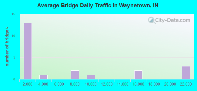
- 120,622Total average daily traffic
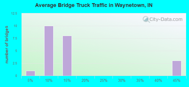
- 19,695Total average daily truck traffic
- National Bridge Inventory (NBI) Registered Bridges for Waynetown
- No street view available for this location
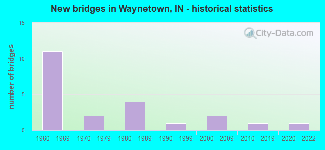
- New bridges - historical statistics
- 111960-1969
- 21970-1979
- 41980-1989
- 11990-1999
- 22000-2009
- 12010-2019
- 12020-2022
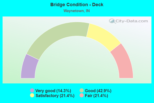
- Bridge Condition - Deck
- 14.3%Very good
- 42.9%Good
- 21.4%Satisfactory
- 21.4%Fair
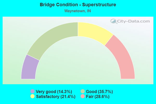
- Bridge Condition - Superstructure
- 14.3%Very good
- 35.7%Good
- 21.4%Satisfactory
- 28.6%Fair
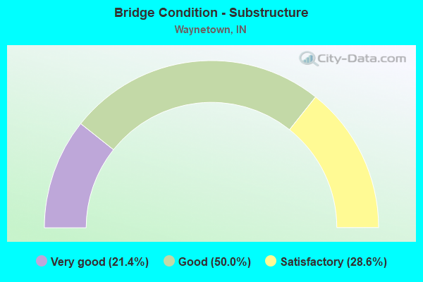
- Bridge Condition - Substructure
- 21.4%Very good
- 50.0%Good
- 28.6%Satisfactory
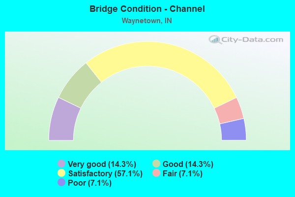
- Bridge Condition - Channel
- 14.3%Very good
- 14.3%Good
- 57.1%Satisfactory
- 7.1%Fair
- 7.1%Poor
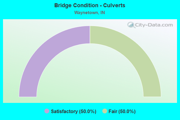
- Bridge Condition - Culverts
- 50.0%Satisfactory
- 50.0%Fair
Find on map >> Show street view
Structure Number: 26831, Location: 01.97 W SR 25 (Lat: 40.091131, Lng: -87.103550), Route carried "on" structure: US 136, Year Built: 2021, Status: Open, Structure Length: 3.29m (10.79ft), Average Daily Traffic: 2,080 (year 2020), Truck Traffic: 3%, Average Future Daily Traffic: 3,294 (year 2032), Design Load: HL 93, Features Intersected: EAST FORK COAL CREEK
Minimum Vertical Clearance: 30+ m (98+ ft), Kilometerpoint: 28.389, Lanes on structure: 2, Owner: State Highway Agency, Approaching Roadway Width: 10.7m (35.1ft), Skew: 2 degrees, Material/Design: Prestressed concrete, Design/Construction: Tee Beam, Number Of Spans In Main Unit: 1, Length of Maximum Span: 32.0m (105.0ft), Curb-To-Curb Width: 10.8m (35.4ft), Out-to-Out Width: 11.7m (38.4ft)
Condition: Deck: Very good, Superstructure: Very good, Substructure: Very good, Channel: Very good, Operating Rating: 60.6 metric tons, Method Used To Determine Operating Rating: Load and Resistance Factor Rating (LRFR) rating reported by rating factor(RF) method using HL-93 loadings, Inventory Rating: 40.2 metric tons, Method Used To Determine Inventory Rating: Load and Resistance Factor Rating (LRFR) rating reported by rating factor(RF) method using HL-93 loadings, Structural Evaluation: Equal to present desirable criteria, Deck Geometry: Somewhat better than minimum adequacy, Waterway Adequacy: Superior to present desirable criteria, Approach Roadway Alignment: Equal to present desirable criteria, Designated Inspection Frequency: Every 24 months, Inspection Date: October 2021, Deck Structure Type: Concrete Cast-file-Place, Wearing Surface/Protective System: Wearing Surface: Monolithic Concrete, Deck Protection: Epoxy Coated Reinforcing
Find on map >> Show street view
Structure Number: 4397, Location: 01.30 W SR 25 (Lat: 40.109961, Lng: -87.091919), Route carried "on" structure: Alternate County highway , Year Built: 1963, Status: Open, Structure Length: 6.55m (21.49ft), Average Daily Traffic: 455 (year 2004), Truck Traffic: 10%, Average Future Daily Traffic: 755 (year 2030), Design Load: HS 20, Features Intersected: I-74 EB/WB, Facility Carried by Structure: COUNTY LINE RD
Minimum Vertical Clearance: 30+ m (98+ ft), Kilometerpoint: 0.000, Lanes on structure: 2, Lanes under structure: 4, Owner: State Highway Agency, Approaching Roadway Width: 6.1m (20.0ft), Skew: 1 degrees, Material/Design: Concrete continuous, Design/Construction: Stringer/Multi-beam, Number Of Spans In Main Unit: 4, Length of Maximum Span: 19.2m (63.0ft), Curb or Sidewalk Widths: Left: 0.5m (1.6ft), Right: 0.5m (1.6ft), Curb-To-Curb Width: 7.3m (24.0ft), Out-to-Out Width: 9.0m (29.5ft)
Condition: Deck: Good, Superstructure: Good, Substructure: Satisfactory, Operating Rating: 58.6 metric tons, Method Used To Determine Operating Rating: Load Factor (LF), Inventory Rating: 35.1 metric tons, Method Used To Determine Inventory Rating: Load Factor (LF), Structural Evaluation: Equal to present minimum criteria, Deck Geometry: Meets minimum limits, Underclear: Meets minimum limits, Approach Roadway Alignment: Equal to present desirable criteria, Designated Inspection Frequency: Every 24 months, Inspection Date: September 2020, Deck Structure Type: Concrete Cast-file-Place, Wearing Surface/Protective System: Wearing Surface: Monolithic Concrete
Find on map >> Show street view
Structure Number: 4399, Location: 01.68 E SR 25 (Lat: 40.099639, Lng: -87.037769), Route carried "on" structure: Interstate 74, Year Built: 1963, Year Reconstructed: 2019, Status: Open, Structure Length: 2.80m (9.19ft), Average Daily Traffic: 8,350 (year 2018), Truck Traffic: 41%, Average Future Daily Traffic: 9,760 (year 2038), Design Load: HS 20, Features Intersected: EAST FORK COAL CREEK
Minimum Vertical Clearance: 30+ m (98+ ft), Kilometerpoint: 42.744, Lanes on structure: 2, Base Highway Network: Yes (, Subroute: 1), Owner: State Highway Agency, Approaching Roadway Width: 11.6m (38.1ft), Skew: 2 degrees, Material/Design: Concrete continuous, Design/Construction: Slab, Number Of Spans In Main Unit: 3, Length of Maximum Span: 11.0m (36.1ft), Curb-To-Curb Width: 12.2m (40.0ft), Out-to-Out Width: 13.1m (43.0ft)
Condition: Deck: Good, Superstructure: Good, Substructure: Good, Channel: Very good, Operating Rating: 46.7 metric tons, Method Used To Determine Operating Rating: Load and Resistance Factor Rating (LRFR) rating reported by rating factor(RF) method using HL-93 loadings, Inventory Rating: 36.0 metric tons, Method Used To Determine Inventory Rating: Load and Resistance Factor Rating (LRFR) rating reported by rating factor(RF) method using HL-93 loadings, Structural Evaluation: Better than present minimum criteria, Deck Geometry: Better than present minimum criteria, Waterway Adequacy: Equal to present desirable criteria, Approach Roadway Alignment: Equal to present desirable criteria, Designated Inspection Frequency: Every 24 months, Inspection Date: December 2021, Deck Structure Type: Concrete Cast-file-Place, Wearing Surface/Protective System: Wearing Surface: Latex Concrete
Find on map >> Show street view
Structure Number: 44, Location: 02.53 E SR 25 (Lat: 40.099439, Lng: -87.021689), Route carried "on" structure: Alternate County highway , Year Built: 1964, Year Reconstructed: 2016, Status: Open, Structure Length: 6.04m (19.82ft), Average Daily Traffic: 132 (year 2004), Truck Traffic: 10%, Average Future Daily Traffic: 217 (year 2030), Design Load: HS 20, Features Intersected: I-74 EB/WB, Facility Carried by Structure: WESLEY STATION RD
Minimum Vertical Clearance: 30+ m (98+ ft), Kilometerpoint: 0.000, Lanes on structure: 2, Lanes under structure: 4, Owner: State Highway Agency, Approaching Roadway Width: 6.1m (20.0ft), Material/Design: Steel continuous, Design/Construction: Stringer/Multi-beam, Number Of Spans In Main Unit: 2, Number Of Approach Spans: 2, Length of Maximum Span: 18.3m (60.0ft), Curb or Sidewalk Widths: Left: 0.5m (1.6ft), Right: 0.5m (1.6ft), Curb-To-Curb Width: 7.3m (24.0ft), Out-to-Out Width: 9.0m (29.5ft)
Condition: Deck: Good, Superstructure: Satisfactory, Substructure: Good, Operating Rating: 48.9 metric tons, Method Used To Determine Operating Rating: Load and Resistance Factor Rating (LRFR) rating reported by rating factor(RF) method using HL-93 loadings, Inventory Rating: 37.6 metric tons, Method Used To Determine Inventory Rating: Load and Resistance Factor Rating (LRFR) rating reported by rating factor(RF) method using HL-93 loadings, Structural Evaluation: Equal to present minimum criteria, Deck Geometry: Somewhat better than minimum adequacy, Underclear: Meets minimum limits, Approach Roadway Alignment: Equal to present desirable criteria, Designated Inspection Frequency: Every 24 months, Inspection Date: September 2020, Deck Structure Type: Concrete Cast-file-Place, Wearing Surface/Protective System: Wearing Surface: Latex Concrete
Find on map >> Show street view
Structure Number: 4401, Location: 03.66 E SR 25 (Lat: 40.098250, Lng: -87.005639), Route carried "on" structure: Interstate 74, Year Built: 1964, Status: Open, Structure Length: 0.73m (2.40ft), Average Daily Traffic: 20,469 (year 2004), Truck Traffic: 10%, Average Future Daily Traffic: 37,070 (year 2030), Design Load: HS 20+Mod, Features Intersected: REMLEY DITCH
Minimum Vertical Clearance: 30+ m (98+ ft), Kilometerpoint: 45.931, Lanes on structure: 4, Base Highway Network: Yes (, Subroute: 1), Owner: State Highway Agency, Approaching Roadway Width: 36.0m (118.1ft), Skew: 12 degrees, Material/Design: Concrete, Design/Construction: Culvert, Number Of Spans In Main Unit: 1, Length of Maximum Span: 6.2m (20.3ft)
Condition: Channel: Satisfactory, Culverts: Satisfactory, Operating Rating: 70.3 metric tons, Method Used To Determine Operating Rating: Load and Resistance Factor Rating (LRFR) rating reported by rating factor(RF) method using HL-93 loadings, Inventory Rating: 54.1 metric tons, Method Used To Determine Inventory Rating: Load and Resistance Factor Rating (LRFR) rating reported by rating factor(RF) method using HL-93 loadings, Structural Evaluation: Equal to present minimum criteria, Waterway Adequacy: Superior to present desirable criteria, Approach Roadway Alignment: Equal to present desirable criteria, Designated Inspection Frequency: Every 24 months, Inspection Date: September 2020
Find on map >> Show street view
Structure Number: 230004, Location: 00.30 N of Jct US 136 (Lat: 40.090161, Lng: -87.091919), Route carried "on" structure: County highway 83, Year Built: 1983, Status: Open, Structure Length: 5.25m (17.22ft), Average Daily Traffic: 237 (year 2012), Truck Traffic: 6%, Average Future Daily Traffic: 319 (year 2032), Design Load: HS 20, Features Intersected: E Fork of COAL Creek, Facility Carried by Structure: CR 900E
Minimum Vertical Clearance: 30+ m (98+ ft), Kilometerpoint: 0.000, Lanes on structure: 2, Owner: County Highway Agency, Approaching Roadway Width: 5.8m (19.0ft), Skew: 1 degrees, Material/Design: Prestressed concrete continuous, Design/Construction: Stringer/Multi-beam, Number Of Spans In Main Unit: 3, Length of Maximum Span: 17.4m (57.1ft), Curb-To-Curb Width: 7.3m (24.0ft), Out-to-Out Width: 8.1m (26.6ft)
Condition: Deck: Satisfactory, Superstructure: Satisfactory, Substructure: Good, Channel: Satisfactory, Operating Rating: 55.2 metric tons, Method Used To Determine Operating Rating: Load and Resistance Factor (LRFR), Inventory Rating: 41.5 metric tons, Method Used To Determine Inventory Rating: Load and Resistance Factor (LRFR), Structural Evaluation: Equal to present minimum criteria, Deck Geometry: Somewhat better than minimum adequacy, Waterway Adequacy: Equal to present desirable criteria, Approach Roadway Alignment: Equal to present desirable criteria, Designated Inspection Frequency: Every 48 months, Inspection Date: June 2018, Deck Structure Type: Concrete Cast-file-Place
Find on map >> Show street view
Structure Number: 2300041, Location: 00.50 W of COUNTY LINE Rd (Lat: 40.082839, Lng: -87.100139), Route carried "on" structure: County highway 132, Year Built: 1977, Status: Open, Structure Length: 1.49m (4.89ft), Average Daily Traffic: 117 (year 2012), Truck Traffic: 6%, Average Future Daily Traffic: 158 (year 2032), Features Intersected: Branch of E Fork COAL Cr, Facility Carried by Structure: CR 300S
Minimum Vertical Clearance: 30+ m (98+ ft), Kilometerpoint: 0.000, Lanes on structure: 2, Owner: County Highway Agency, Approaching Roadway Width: 5.5m (18.0ft), Material/Design: Prestressed concrete, Design/Construction: Box Beam or Girders - Multiple, Number Of Spans In Main Unit: 1, Length of Maximum Span: 14.3m (46.9ft), Curb-To-Curb Width: 8.0m (26.2ft), Out-to-Out Width: 8.1m (26.6ft)
Condition: Deck: Fair, Superstructure: Fair, Substructure: Good, Channel: Satisfactory, Operating Rating: 46.2 metric tons, Method Used To Determine Operating Rating: Load and Resistance Factor (LRFR), Inventory Rating: 34.3 metric tons, Method Used To Determine Inventory Rating: Load and Resistance Factor (LRFR), Structural Evaluation: Somewhat better than minimum adequacy, Deck Geometry: Somewhat better than minimum adequacy, Waterway Adequacy: Better than present minimum criteria, Approach Roadway Alignment: Equal to present desirable criteria, Designated Inspection Frequency: Every 24 months, Inspection Date: June 2020, Deck Structure Type: Concrete Precast Panels, Wearing Surface/Protective System: Wearing Surface: Bituminous
Find on map >> Show street view
Structure Number: 2300043, Location: 00.50 S of Jct US 136 (Lat: 40.079589, Lng: -87.091961), Route carried "on" structure: County highway 83, Year Built: 1990, Status: Open, Structure Length: 1.45m (4.76ft), Average Daily Traffic: 117 (year 2012), Truck Traffic: 6%, Average Future Daily Traffic: 158 (year 2032), Features Intersected: Branch of E Fork COAL Cr, Facility Carried by Structure: CR 900E
Minimum Vertical Clearance: 30+ m (98+ ft), Kilometerpoint: 0.000, Lanes on structure: 2, Owner: County Highway Agency, Approaching Roadway Width: 4.6m (15.1ft), Material/Design: Prestressed concrete, Design/Construction: Box Beam or Girders - Multiple, Number Of Spans In Main Unit: 1, Length of Maximum Span: 13.4m (44.0ft), Curb-To-Curb Width: 6.3m (20.7ft), Out-to-Out Width: 6.4m (21.0ft)
Condition: Deck: Fair, Superstructure: Fair, Substructure: Satisfactory, Channel: Fair, Operating Rating: 57.2 metric tons, Method Used To Determine Operating Rating: Load and Resistance Factor (LRFR), Inventory Rating: 42.5 metric tons, Method Used To Determine Inventory Rating: Load and Resistance Factor (LRFR), Structural Evaluation: Somewhat better than minimum adequacy, Deck Geometry: Meets minimum limits, Waterway Adequacy: Equal to present minimum criteria, Approach Roadway Alignment: Equal to present desirable criteria, Designated Inspection Frequency: Every 24 months, Inspection Date: June 2020, Deck Structure Type: Concrete Precast Panels
Find on map >> Show street view
Structure Number: 2300052, Location: 00.20 S of CR 300 S (Lat: 40.081250, Lng: -87.096711), Route carried "on" structure: County highway 167, Year Built: 2017, Status: Open, Structure Length: 1.08m (3.54ft), Average Daily Traffic: 117 (year 2012), Truck Traffic: 6%, Average Future Daily Traffic: 158 (year 2032), Features Intersected: Branch of E Fork COAL Cr, Facility Carried by Structure: CR 875E
Minimum Vertical Clearance: 30+ m (98+ ft), Kilometerpoint: 0.000, Lanes on structure: 2, Owner: County Highway Agency, Approaching Roadway Width: 4.3m (14.1ft), Material/Design: Steel, Design/Construction: Stringer/Multi-beam, Number Of Spans In Main Unit: 1, Length of Maximum Span: 10.1m (33.1ft), Curb-To-Curb Width: 6.7m (22.0ft), Out-to-Out Width: 6.7m (22.0ft)
Condition: Deck: Very good, Superstructure: Good, Substructure: Very good, Channel: Satisfactory, Operating Rating: 90.7 metric tons, Method Used To Determine Operating Rating: Load Factor (LF), Inventory Rating: 54.3 metric tons, Method Used To Determine Inventory Rating: Load Factor (LF), Structural Evaluation: Better than present minimum criteria, Deck Geometry: Meets minimum limits, Waterway Adequacy: Better than present minimum criteria, Approach Roadway Alignment: Equal to present desirable criteria, Designated Inspection Frequency: Every 24 months, Inspection Date: June 2020, Deck Structure Type: Concrete Cast-file-Place, Wearing Surface/Protective System: Wearing Surface: Monolithic Concrete
Find on map >> Show street view
Structure Number: 5400079, Location: 00.50 W of CR 550 W (Lat: 40.053650, Lng: -87.015589), Route carried "on" structure: County highway 198, Year Built: 1982, Status: Open, Structure Length: 1.57m (5.15ft), Average Daily Traffic: 130 (year 2014), Truck Traffic: 5%, Average Future Daily Traffic: 180 (year 2034), Design Load: HS 20, Features Intersected: MILL CREEK, Facility Carried by Structure: CR 100N
Minimum Vertical Clearance: 30+ m (98+ ft), Kilometerpoint: 0.000, Lanes on structure: 2, Owner: County Highway Agency, Approaching Roadway Width: 5.2m (17.1ft), Material/Design: Concrete continuous, Design/Construction: Slab, Number Of Spans In Main Unit: 3, Length of Maximum Span: 6.1m (20.0ft), Curb-To-Curb Width: 7.3m (24.0ft), Out-to-Out Width: 8.1m (26.6ft)
Condition: Deck: Good, Superstructure: Good, Substructure: Good, Channel: Satisfactory, Operating Rating: 44.1 metric tons, Method Used To Determine Operating Rating: Field evaluation and documented engineering judgment, Inventory Rating: 32.7 metric tons, Method Used To Determine Inventory Rating: Field evaluation and documented engineering judgment, Structural Evaluation: Better than present minimum criteria, Deck Geometry: Somewhat better than minimum adequacy, Waterway Adequacy: Somewhat better than minimum adequacy, Approach Roadway Alignment: Equal to present minimum criteria, Designated Inspection Frequency: Every 24 months, Inspection Date: April 2020, Deck Structure Type: Concrete Cast-file-Place, Wearing Surface/Protective System: Wearing Surface: Monolithic Concrete, Membrane: Epoxy
Find on map >> Show street view
Structure Number: 5400081, Location: 00.50 S of CR 450N (Lat: 40.097561, Lng: -87.021711), Route carried "on" structure: County highway 19, Year Built: 1965, Year Reconstructed: 2017, Status: Open, Structure Length: 2.62m (8.60ft), Average Daily Traffic: 490 (year 2014), Truck Traffic: 8%, Average Future Daily Traffic: 690 (year 2034), Features Intersected: EAST FORK OF COAL CREEK, Facility Carried by Structure: CR 625W
Minimum Vertical Clearance: 30+ m (98+ ft), Kilometerpoint: 0.000, Lanes on structure: 2, Owner: County Highway Agency, Approaching Roadway Width: 6.1m (20.0ft), Material/Design: Concrete, Design/Construction: Stringer/Multi-beam, Number Of Spans In Main Unit: 3, Length of Maximum Span: 9.9m (32.5ft), Curb or Sidewalk Widths: Left: 0.4m (1.3ft), Right: 0.4m (1.3ft), Curb-To-Curb Width: 7.3m (24.0ft), Out-to-Out Width: 8.8m (28.9ft)
Condition: Deck: Satisfactory, Superstructure: Fair, Substructure: Satisfactory, Channel: Satisfactory, Operating Rating: 40.8 metric tons, Method Used To Determine Operating Rating: Field evaluation and documented engineering judgment, Inventory Rating: 30.4 metric tons, Method Used To Determine Inventory Rating: Field evaluation and documented engineering judgment, Structural Evaluation: Somewhat better than minimum adequacy, Deck Geometry: Meets minimum limits, Waterway Adequacy: Equal to present desirable criteria, Approach Roadway Alignment: Equal to present minimum criteria, Designated Inspection Frequency: Every 24 months, Inspection Date: April 2020, Deck Structure Type: Concrete Cast-file-Place, Wearing Surface/Protective System: Wearing Surface: Monolithic Concrete
Find on map >> Show street view
Structure Number: 5400082, Location: 00.75 W of CR 625 W (Lat: 40.102650, Lng: -87.035800), Route carried "on" structure: County highway 56, Year Built: 1970, Status: Open, Structure Length: 2.19m (7.19ft), Average Daily Traffic: 160 (year 2014), Truck Traffic: 10%, Average Future Daily Traffic: 230 (year 2034), Design Load: HS 20, Features Intersected: CLARKSON DITCH, Facility Carried by Structure: CR 450N
Minimum Vertical Clearance: 30+ m (98+ ft), Kilometerpoint: 0.000, Lanes on structure: 2, Owner: County Highway Agency, Approaching Roadway Width: 5.5m (18.0ft), Skew: 3 degrees, Material/Design: Concrete continuous, Design/Construction: Slab, Number Of Spans In Main Unit: 3, Length of Maximum Span: 8.5m (27.9ft), Curb-To-Curb Width: 7.9m (25.9ft), Out-to-Out Width: 8.7m (28.5ft)
Condition: Deck: Fair, Superstructure: Fair, Substructure: Good, Channel: Satisfactory, Operating Rating: 58.8 metric tons, Method Used To Determine Operating Rating: Load Factor (LF), Inventory Rating: 35.3 metric tons, Method Used To Determine Inventory Rating: Load Factor (LF), Structural Evaluation: Somewhat better than minimum adequacy, Deck Geometry: Somewhat better than minimum adequacy, Waterway Adequacy: Equal to present minimum criteria, Approach Roadway Alignment: Equal to present minimum criteria, Designated Inspection Frequency: Every 24 months, Inspection Date: April 2020, Deck Structure Type: Concrete Cast-file-Place, Wearing Surface/Protective System: Wearing Surface: Monolithic Concrete
Find on map >> Show street view
Structure Number: 5400083, Location: 00.70 W of SR 25 (Lat: 40.104419, Lng: -87.084189), Route carried "on" structure: County highway 218, Year Built: 1986, Status: Open, Structure Length: 0.62m (2.03ft), Average Daily Traffic: 60 (year 2014), Truck Traffic: 5%, Average Future Daily Traffic: 80 (year 2034), Features Intersected: BRANCH OF COAL CREEK, Facility Carried by Structure: CR 450N
Minimum Vertical Clearance: 30+ m (98+ ft), Kilometerpoint: 0.000, Lanes on structure: 2, Owner: County Highway Agency, Approaching Roadway Width: 5.8m (19.0ft), Skew: 1 degrees, Material/Design: Steel, Design/Construction: Culvert, Number Of Spans In Main Unit: 2, Length of Maximum Span: 2.6m (8.5ft)
Condition: Channel: Poor, Culverts: Fair, Operating Rating: 32.7 metric tons, Method Used To Determine Operating Rating: Field evaluation and documented engineering judgment, Inventory Rating: 32.7 metric tons, Method Used To Determine Inventory Rating: Field evaluation and documented engineering judgment, Structural Evaluation: Somewhat better than minimum adequacy, Waterway Adequacy: Equal to present minimum criteria, Approach Roadway Alignment: Equal to present minimum criteria, Designated Inspection Frequency: Every 24 months, Inspection Date: April 2020
Find on map >> Show street view
Structure Number: 5400084, Location: 00.60 W of CR 600 W (Lat: 40.111231, Lng: -87.027569), Route carried "on" structure: County highway 306, Year Built: 1987, Status: Open, Structure Length: 1.30m (4.27ft), Average Daily Traffic: 100 (year 2014), Truck Traffic: 5%, Average Future Daily Traffic: 140 (year 2034), Features Intersected: CLARKSON DITCH, Facility Carried by Structure: CR 500N
Minimum Vertical Clearance: 30+ m (98+ ft), Kilometerpoint: 0.000, Lanes on structure: 2, Owner: County Highway Agency, Approaching Roadway Width: 4.9m (16.1ft), Skew: 1 degrees, Material/Design: Prestressed concrete, Design/Construction: Box Beam or Girders - Multiple, Number Of Spans In Main Unit: 1, Length of Maximum Span: 12.3m (40.4ft), Curb-To-Curb Width: 7.3m (24.0ft), Out-to-Out Width: 7.4m (24.3ft)
Condition: Deck: Satisfactory, Superstructure: Satisfactory, Substructure: Satisfactory, Channel: Satisfactory, Operating Rating: 44.1 metric tons, Method Used To Determine Operating Rating: Field evaluation and documented engineering judgment, Inventory Rating: 32.7 metric tons, Method Used To Determine Inventory Rating: Field evaluation and documented engineering judgment, Structural Evaluation: Equal to present minimum criteria, Deck Geometry: Equal to present minimum criteria, Waterway Adequacy: Somewhat better than minimum adequacy, Approach Roadway Alignment: Equal to present minimum criteria, Length Of Structure Improvement: 1.30m (4.27ft), Designated Inspection Frequency: Every 24 months, Inspection Date: April 2020, Bridge Improvement Cost: $50,000, Roadway Improvement Cost: $50,000, Total Project Cost: $100,000, Deck Structure Type: Concrete Precast Panels, Wearing Surface/Protective System: Wearing Surface: Monolithic Concrete
Find on map >> Show street view
Structure Number: 5400087, Location: 00.30 E of CR 950 W (Lat: 40.068161, Lng: -87.078211), Route carried "on" structure: County highway 200, Year Built: 2002, Status: Posted for load, Structure Length: 1.55m (5.09ft), Average Daily Traffic: 110 (year 2014), Truck Traffic: 5%, Average Future Daily Traffic: 160 (year 2034), Design Load: HS 20, Features Intersected: BRANCH OF COAL CREEK
Minimum Vertical Clearance: 30+ m (98+ ft), Kilometerpoint: 0.000, Lanes on structure: 2, Owner: County Highway Agency, Approaching Roadway Width: 5.8m (19.0ft), Skew: 1 degrees, Material/Design: Prestressed concrete, Design/Construction: Box Beam or Girders - Single/Spread, Number Of Spans In Main Unit: 1, Length of Maximum Span: 14.8m (48.6ft), Curb-To-Curb Width: 8.0m (26.2ft), Out-to-Out Width: 8.1m (26.6ft)
Condition: Deck: Good, Superstructure: Very good, Substructure: Very good, Channel: Good, Operating Rating: 37.9 metric tons, Method Used To Determine Operating Rating: Load Factor (LF), Inventory Rating: 22.5 metric tons, Method Used To Determine Inventory Rating: Load Factor (LF), Structural Evaluation: Equal to present minimum criteria, Deck Geometry: Somewhat better than minimum adequacy, Waterway Adequacy: Better than present minimum criteria, Approach Roadway Alignment: Equal to present desirable criteria, Designated Inspection Frequency: Every 24 months, Inspection Date: April 2020, Deck Structure Type: Concrete Cast-file-Place, Wearing Surface/Protective System: Wearing Surface: Monolithic Concrete, Deck Protection: Epoxy Coated Reinforcing
Find on map >> Show street view
Structure Number: 5400088, Location: 00.70 S of US 136 (Lat: 40.076989, Lng: -87.082561), Route carried "on" structure: County highway 213, Year Built: 2002, Status: Open, Structure Length: 2.68m (8.79ft), Average Daily Traffic: 60 (year 2014), Truck Traffic: 5%, Average Future Daily Traffic: 80 (year 2034), Features Intersected: BRANCH OF COAL CREEK, Facility Carried by Structure: CR 950W
Minimum Vertical Clearance: 30+ m (98+ ft), Kilometerpoint: 0.000, Lanes on structure: 2, Owner: County Highway Agency, Approaching Roadway Width: 6.1m (20.0ft), Material/Design: Concrete continuous, Design/Construction: Slab, Number Of Spans In Main Unit: 3, Length of Maximum Span: 10.2m (33.5ft), Curb-To-Curb Width: 7.3m (24.0ft), Out-to-Out Width: 7.5m (24.6ft)
Condition: Deck: Good, Superstructure: Good, Substructure: Good, Channel: Good, Operating Rating: 44.1 metric tons, Method Used To Determine Operating Rating: Field evaluation and documented engineering judgment, Inventory Rating: 32.7 metric tons, Method Used To Determine Inventory Rating: Field evaluation and documented engineering judgment, Structural Evaluation: Better than present minimum criteria, Deck Geometry: Equal to present minimum criteria, Waterway Adequacy: Equal to present minimum criteria, Approach Roadway Alignment: Equal to present minimum criteria, Designated Inspection Frequency: Every 24 months, Inspection Date: April 2020, Deck Structure Type: Concrete Cast-file-Place, Wearing Surface/Protective System: Wearing Surface: Monolithic Concrete, Deck Protection: Epoxy Coated Reinforcing
Find on map >> Show street view
Structure Number: 628, Location: 01.04 N US 136 (Lat: 40.104350, Lng: -87.068467), Route carried "under" structure: Interstate 74, Year Built: 1963, Structure Length: 0. m, Average Daily Traffic: 20,469 (year 2004), Truck Traffic: 10%, Features Intersected: I-74 WBL, Facility Carried by Structure: SR 25
Minimum Vertical Clearance: 4.98m (16.34ft), Kilometerpoint: 40.040, Lanes on structure: 2, Lanes under structure: 4, Material/Design: Steel continuous, Design/Construction: Stringer/Multi-beam, Length of Maximum Span: 19.5m (64.0ft)
Find on map >> Show street view
Structure Number: 628, Location: 01.04 N US 136 (Lat: 40.104350, Lng: -87.068467), Route carried "under" structure: Interstate 74, Year Built: 1963, Structure Length: 0. m, Average Daily Traffic: 20,469 (year 2004), Truck Traffic: 10%, Features Intersected: I-74 EBL, Facility Carried by Structure: SR 25
Minimum Vertical Clearance: 4.98m (16.34ft), Kilometerpoint: 40.040, Lanes on structure: 2, Lanes under structure: 4, Material/Design: Steel continuous, Design/Construction: Stringer/Multi-beam, Length of Maximum Span: 19.5m (64.0ft)
Find on map >> Show street view
Structure Number: 4397, Location: 01.30 W SR 25 (Lat: 40.109961, Lng: -87.091928), Route carried "under" structure: Interstate 74, Year Built: 1963, Structure Length: 0. m, Average Daily Traffic: 15,290 (year 2004), Truck Traffic: 10%, Features Intersected: I-74 WB, Facility Carried by Structure: COUNTY LINE RD
Minimum Vertical Clearance: 5.39m (17.68ft), Kilometerpoint: 37.948, Lanes on structure: 2, Lanes under structure: 4, Material/Design: Concrete continuous, Design/Construction: Stringer/Multi-beam, Length of Maximum Span: 19.2m (63.0ft)
Find on map >> Show street view
Structure Number: 4397, Location: 01.30 W SR 25 (Lat: 40.109961, Lng: -87.091928), Route carried "under" structure: Interstate 74, Year Built: 1963, Structure Length: 0. m, Average Daily Traffic: 15,290 (year 2004), Truck Traffic: 10%, Features Intersected: I-74 EB, Facility Carried by Structure: COUNTY LINE RD
Minimum Vertical Clearance: 5.36m (17.59ft), Kilometerpoint: 37.948, Lanes on structure: 2, Lanes under structure: 4, Material/Design: Concrete continuous, Design/Construction: Stringer/Multi-beam, Length of Maximum Span: 19.2m (63.0ft)
Find on map >> Show street view
Structure Number: 44, Location: 02.53 E SR 25 (Lat: 40.099439, Lng: -87.021697), Route carried "under" structure: Interstate 74, Year Built: 1964, Structure Length: 0. m, Average Daily Traffic: 7,960 (year 2010), Truck Traffic: 43%, Features Intersected: I-74 EBL, Facility Carried by Structure: WESLEY STATION RD
Minimum Vertical Clearance: 4.93m (16.17ft), Kilometerpoint: 44.112, Lanes on structure: 2, Lanes under structure: 4, Material/Design: Steel continuous, Design/Construction: Stringer/Multi-beam, Length of Maximum Span: 18.3m (60.0ft)
Find on map >> Show street view
Structure Number: 44, Location: 02.53 E SR 25 (Lat: 40.099439, Lng: -87.021697), Route carried "under" structure: Interstate 74, Year Built: 1964, Structure Length: 0. m, Average Daily Traffic: 7,960 (year 2010), Truck Traffic: 43%, Features Intersected: I-74 WBL, Facility Carried by Structure: WESLEY STATION RD
Minimum Vertical Clearance: 4.93m (16.17ft), Kilometerpoint: 44.112, Lanes on structure: 2, Lanes under structure: 4, Material/Design: Steel continuous, Design/Construction: Stringer/Multi-beam, Length of Maximum Span: 18.3m (60.0ft)