Bridge Statistics for Wayland, New York (NY)
Condition, Traffic, Stress, Structural Evaluation, Project Costs
- National Bridge Inventory (NBI) Statistics
- 19Number of bridges
- 151ft / 46.3mTotal length
- $28,877,000Total costs
- 58,859Total average daily traffic
- 17,798Total average daily truck traffic
- National Bridge Inventory (NBI) Registered Bridges for Wayland
- No street view available for this location
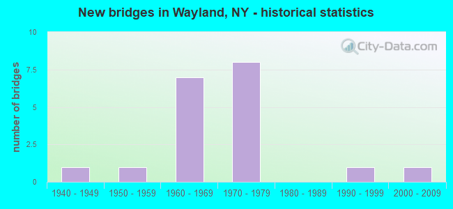
- New bridges - historical statistics
- 11940-1949
- 11950-1959
- 71960-1969
- 81970-1979
- 11990-1999
- 12000-2009

- Reconstructed bridges - Historical Statistics
- 11980-1989
- 21990-1999
- 02000-2009
- 22010-2019


- Bridge Condition - Deck
- 20.0%Excellent
- 30.0%Good
- 40.0%Satisfactory
- 10.0%Poor

- Bridge Condition - Superstructure
- 40.0%Good
- 60.0%Satisfactory

- Bridge Condition - Substructure
- 40.0%Good
- 50.0%Satisfactory
- 10.0%Fair

- Bridge Condition - Channel
- 71.4%Satisfactory
- 14.3%Fair
- 14.3%Poor
Find on map >> Show street view
Structure Number: 1013021, Location: JCT RTE 434 & SUSQUEHANNA (Lat: 42.092267, Lng: -75.911342), Route carried "on" structure: State highway 434, Year Built: 1956, Year Reconstructed: 1993, Status: Open, Structure Length: 19.75m (64.80ft), Average Daily Traffic: 9,929 (year 2009), Truck Traffic: 4%, Average Future Daily Traffic: 11,505 (year 2040), Design Load: HS 20, Features Intersected: RTE 363, SUSQUEHANNA RIV
Minimum Vertical Clearance: 30+ m (98+ ft), Kilometerpoint: 17.458, Lanes on structure: 3, Lanes under structure: 7, Base Highway Network: Yes, Owner: State Highway Agency, Approaching Roadway Width: 11.6m (38.1ft), Material/Design: Steel continuous, Design/Construction: Girder and Floorbeam System, Number Of Spans In Main Unit: 3, Number Of Approach Spans: 2, Length of Maximum Span: 62.1m (203.7ft), Curb or Sidewalk Widths: Left: 1.5m (4.9ft), Right: 0.0m, Curb-To-Curb Width: 11.4m (37.4ft), Out-to-Out Width: 13.7m (44.9ft)
Condition: Deck: Satisfactory, Superstructure: Good, Substructure: Satisfactory, Channel: Satisfactory, Operating Rating: 44.5 metric tons, Method Used To Determine Operating Rating: Load Factor (LF), Inventory Rating: 26.3 metric tons, Method Used To Determine Inventory Rating: Load Factor (LF), Structural Evaluation: Equal to present minimum criteria, Deck Geometry: High priority of replacement, Underclear: High priority of corrective action, Waterway Adequacy: Equal to present minimum criteria, Approach Roadway Alignment: Equal to present desirable criteria, Length Of Structure Improvement: 19.75m (64.80ft), Designated Inspection Frequency: Every 24 months, Critical Feature Inspection Frequency: Every 24 months, Underwater Inspection Frequency: Every 60 months, Inspection Date: October 2021, Critical Feature Inspection Date: October 2021, Underwater Inspection Date: August 2018, Bridge Improvement Cost: $6,053,000, Roadway Improvement Cost: $3,544,000, Total Project Cost: $9,597,000 ( Estimate for 2021), Deck Structure Type: Concrete Cast-file-Place, Wearing Surface/Protective System: Wearing Surface: Integral Concrete, Deck Protection: Epoxy Coated Reinforcing
Find on map >> Show street view
Structure Number: 101641, Location: 3.0 MI E OF WAYLAND (Lat: 42.567203, Lng: -77.536003), Route carried "on" structure: State highway 21, Year Built: 1940, Status: Open, Structure Length: 1.46m (4.79ft), Average Daily Traffic: 1,633 (year 2020), Truck Traffic: 9%, Average Future Daily Traffic: 1,643 (year 2040), Design Load: HS 20, Features Intersected: COHOCTON RIVER
Minimum Vertical Clearance: 30+ m (98+ ft), Kilometerpoint: 46.516, Lanes on structure: 2, Base Highway Network: Yes, Owner: State Highway Agency, Approaching Roadway Width: 9.8m (32.2ft), Skew: 1 degrees, Material/Design: Steel, Design/Construction: Stringer/Multi-beam, Number Of Spans In Main Unit: 1, Length of Maximum Span: 13.7m (44.9ft), Curb-To-Curb Width: 9.9m (32.5ft), Out-to-Out Width: 10.5m (34.4ft)
Condition: Deck: Poor, Superstructure: Satisfactory, Substructure: Fair, Channel: Satisfactory, Operating Rating: 47.2 metric tons, Method Used To Determine Operating Rating: Load Factor (LF), Inventory Rating: 28.1 metric tons, Method Used To Determine Inventory Rating: Load Factor (LF), Structural Evaluation: Somewhat better than minimum adequacy, Deck Geometry: Somewhat better than minimum adequacy, Waterway Adequacy: Somewhat better than minimum adequacy, Approach Roadway Alignment: Equal to present desirable criteria, Length Of Structure Improvement: 1.46m (4.79ft), Designated Inspection Frequency: Every 24 months, Inspection Date: June 2021, Bridge Improvement Cost: $743,000, Roadway Improvement Cost: $435,000, Total Project Cost: $1,178,000 ( Estimate for 2021), Deck Structure Type: Concrete Cast-file-Place, Wearing Surface/Protective System: Wearing Surface: Bituminous
Find on map >> Show street view
Structure Number: 1090711, Location: 0.8 MI E JCT SR 21 & I390 (Lat: 42.539494, Lng: -77.569000), Route carried "on" structure: Interstate 390, Year Built: 1975, Year Reconstructed: 2004, Status: Open, Structure Length: 2.65m (8.69ft), Average Daily Traffic: 5,546 (year 2013), Truck Traffic: 37%, Design Load: HS 20+Mod, Features Intersected: YOCUM ROAD
Minimum Vertical Clearance: 30+ m (98+ ft), Kilometerpoint: 24.940, Lanes on structure: 2, Lanes under structure: 2, Base Highway Network: Yes, Owner: State Highway Agency, Approaching Roadway Width: 12.5m (41.0ft), Skew: 2 degrees, Material/Design: Steel, Design/Construction: Stringer/Multi-beam, Number Of Spans In Main Unit: 1, Length of Maximum Span: 25.6m (84.0ft), Curb-To-Curb Width: 12.5m (41.0ft), Out-to-Out Width: 13.4m (44.0ft)
Condition: Deck: Good, Superstructure: Satisfactory, Substructure: Satisfactory, Operating Rating: 78.0 metric tons, Method Used To Determine Operating Rating: Load Factor (LF), Inventory Rating: 46.3 metric tons, Method Used To Determine Inventory Rating: Load Factor (LF), Structural Evaluation: Equal to present minimum criteria, Deck Geometry: Better than present minimum criteria, Underclear: Meets minimum limits, Approach Roadway Alignment: Equal to present desirable criteria, Length Of Structure Improvement: 2.65m (8.69ft), Designated Inspection Frequency: Every 24 months, Inspection Date: June 2020, Bridge Improvement Cost: $1,381,000, Roadway Improvement Cost: $809,000, Total Project Cost: $2,189,000 ( Estimate for 2021), Deck Structure Type: Concrete Cast-file-Place, Wearing Surface/Protective System: Wearing Surface: Integral Concrete, Deck Protection: Epoxy Coated Reinforcing
Find on map >> Show street view
Structure Number: 1090712, Location: .8 MI E JCT SR 21 & I390 (Lat: 42.539947, Lng: -77.568975), Route carried "on" structure: Interstate 390, Year Built: 1975, Year Reconstructed: 2004, Status: Open, Structure Length: 2.65m (8.69ft), Average Daily Traffic: 4,759 (year 2019), Truck Traffic: 31%, Average Future Daily Traffic: 8,877 (year 2040), Design Load: HS 20+Mod, Features Intersected: YOCUM ROAD
Minimum Vertical Clearance: 30+ m (98+ ft), Kilometerpoint: 25.052, Lanes on structure: 2, Lanes under structure: 2, Base Highway Network: Yes, Owner: State Highway Agency, Approaching Roadway Width: 12.5m (41.0ft), Skew: 2 degrees, Material/Design: Steel, Design/Construction: Stringer/Multi-beam, Number Of Spans In Main Unit: 1, Length of Maximum Span: 25.6m (84.0ft), Curb-To-Curb Width: 12.5m (41.0ft), Out-to-Out Width: 13.4m (44.0ft)
Condition: Deck: Good, Superstructure: Satisfactory, Substructure: Satisfactory, Operating Rating: 76.2 metric tons, Method Used To Determine Operating Rating: Load Factor (LF), Inventory Rating: 45.4 metric tons, Method Used To Determine Inventory Rating: Load Factor (LF), Structural Evaluation: Equal to present minimum criteria, Deck Geometry: Better than present minimum criteria, Underclear: Meets minimum limits, Approach Roadway Alignment: Equal to present desirable criteria, Length Of Structure Improvement: 2.65m (8.69ft), Designated Inspection Frequency: Every 24 months, Inspection Date: June 2020, Bridge Improvement Cost: $1,442,000, Roadway Improvement Cost: $845,000, Total Project Cost: $2,287,000 ( Estimate for 2021), Deck Structure Type: Concrete Cast-file-Place, Wearing Surface/Protective System: Wearing Surface: Integral Concrete, Deck Protection: Epoxy Coated Reinforcing
Find on map >> Show street view
Structure Number: 1090721, Location: JCT RTS 21 + I390 (Lat: 42.541769, Lng: -77.592528), Route carried "on" structure: Interstate 390, Year Built: 1975, Status: Open, Structure Length: 3.63m (11.91ft), Average Daily Traffic: 5,667 (year 2014), Truck Traffic: 37%, Design Load: HS 20+Mod, Features Intersected: RTE 21
Minimum Vertical Clearance: 30+ m (98+ ft), Kilometerpoint: 26.902, Lanes on structure: 2, Lanes under structure: 2, Base Highway Network: Yes, Owner: State Highway Agency, Approaching Roadway Width: 12.8m (42.0ft), Material/Design: Steel, Design/Construction: Stringer/Multi-beam, Number Of Spans In Main Unit: 1, Length of Maximum Span: 35.3m (115.8ft), Curb-To-Curb Width: 12.5m (41.0ft), Out-to-Out Width: 13.4m (44.0ft)
Condition: Deck: Satisfactory, Superstructure: Satisfactory, Substructure: Satisfactory, Operating Rating: 48.0 metric tons, Method Used To Determine Operating Rating: Load and Resistance Factor Rating (LRFR) rating reported by rating factor(RF) method using HL-93 loadings, Inventory Rating: 36.9 metric tons, Method Used To Determine Inventory Rating: Load and Resistance Factor Rating (LRFR) rating reported by rating factor(RF) method using HL-93 loadings, Structural Evaluation: Equal to present minimum criteria, Underclear: Meets minimum limits, Approach Roadway Alignment: Equal to present desirable criteria, Length Of Structure Improvement: 3.62m (11.88ft), Designated Inspection Frequency: Every 24 months, Inspection Date: August 2021, Bridge Improvement Cost: $1,700,000, Roadway Improvement Cost: $995,000, Total Project Cost: $2,695,000 ( Estimate for 2021), Deck Structure Type: Concrete Cast-file-Place, Wearing Surface/Protective System: Wearing Surface: Integral Concrete, Deck Protection: Epoxy Coated Reinforcing
Find on map >> Show street view
Structure Number: 1090722, Location: JCT RTS 21 + I390 (Lat: 42.541997, Lng: -77.592589), Route carried "on" structure: Interstate 390, Year Built: 1975, Status: Open, Structure Length: 3.63m (11.91ft), Average Daily Traffic: 5,007 (year 2020), Truck Traffic: 49%, Average Future Daily Traffic: 9,340 (year 2040), Design Load: HS 20+Mod, Features Intersected: RTE 21
Minimum Vertical Clearance: 30+ m (98+ ft), Kilometerpoint: 26.967, Lanes on structure: 2, Lanes under structure: 2, Base Highway Network: Yes, Owner: State Highway Agency, Approaching Roadway Width: 12.8m (42.0ft), Material/Design: Steel, Design/Construction: Stringer/Multi-beam, Number Of Spans In Main Unit: 1, Length of Maximum Span: 35.3m (115.8ft), Curb-To-Curb Width: 12.5m (41.0ft), Out-to-Out Width: 13.5m (44.3ft)
Condition: Deck: Satisfactory, Superstructure: Satisfactory, Substructure: Satisfactory, Operating Rating: 48.6 metric tons, Method Used To Determine Operating Rating: Load and Resistance Factor Rating (LRFR) rating reported by rating factor(RF) method using HL-93 loadings, Inventory Rating: 37.6 metric tons, Method Used To Determine Inventory Rating: Load and Resistance Factor Rating (LRFR) rating reported by rating factor(RF) method using HL-93 loadings, Structural Evaluation: Equal to present minimum criteria, Deck Geometry: Better than present minimum criteria, Underclear: Somewhat better than minimum adequacy, Approach Roadway Alignment: Equal to present desirable criteria, Length Of Structure Improvement: 3.62m (11.88ft), Designated Inspection Frequency: Every 24 months, Inspection Date: August 2021, Bridge Improvement Cost: $1,708,000, Roadway Improvement Cost: $1,000,000, Total Project Cost: $2,708,000 ( Estimate for 2021), Deck Structure Type: Concrete Cast-file-Place, Wearing Surface/Protective System: Wearing Surface: Integral Concrete, Deck Protection: Epoxy Coated Reinforcing
Find on map >> Show street view
Structure Number: 1090731, Location: 0.4 MI SW JCT SR21 + I390 (Lat: 42.540717, Lng: -77.597817), Route carried "on" structure: Interstate 390, Year Built: 1966, Status: Open, Structure Length: 1.10m (3.61ft), Average Daily Traffic: 5,667 (year 2014), Truck Traffic: 37%, Design Load: HS 20, Features Intersected: MILL CREEK
Minimum Vertical Clearance: 30+ m (98+ ft), Kilometerpoint: 27.369, Lanes on structure: 3, Base Highway Network: Yes, Owner: State Highway Agency, Approaching Roadway Width: 15.8m (51.8ft), Skew: 1 degrees, Material/Design: Concrete, Design/Construction: Culvert, Number Of Spans In Main Unit: 2, Length of Maximum Span: 4.5m (14.8ft), Curb-To-Curb Width: 15.3m (50.2ft), Out-to-Out Width: 16.8m (55.1ft)
Condition: Channel: Satisfactory, Culverts: Good, Operating Rating: 58.1 metric tons, Method Used To Determine Operating Rating: Load Factor (LF), Inventory Rating: 34.5 metric tons, Method Used To Determine Inventory Rating: Load Factor (LF), Structural Evaluation: Better than present minimum criteria, Deck Geometry: Meets minimum limits, Waterway Adequacy: Meets minimum limits, Approach Roadway Alignment: Equal to present desirable criteria, Length Of Structure Improvement: 1.09m (3.58ft), Designated Inspection Frequency: Every 24 months, Inspection Date: June 2020, Bridge Improvement Cost: $714,000, Roadway Improvement Cost: $418,000, Total Project Cost: $1,133,000 ( Estimate for 2021), Wearing Surface/Protective System: Wearing Surface: Bituminous
Find on map >> Show street view
Structure Number: 1090732, Location: 0.4 MI SW JCT SR21 + I390 (Lat: 42.540919, Lng: -77.598006), Route carried "on" structure: Interstate 390, Year Built: 1966, Status: Open, Structure Length: 1.13m (3.71ft), Average Daily Traffic: 5,007 (year 2020), Truck Traffic: 49%, Average Future Daily Traffic: 9,340 (year 2040), Design Load: HS 20, Features Intersected: MILL CREEK
Minimum Vertical Clearance: 30+ m (98+ ft), Kilometerpoint: 27.433, Lanes on structure: 3, Base Highway Network: Yes, Owner: State Highway Agency, Approaching Roadway Width: 15.8m (51.8ft), Skew: 1 degrees, Material/Design: Concrete, Design/Construction: Culvert, Number Of Spans In Main Unit: 2, Length of Maximum Span: 4.5m (14.8ft), Curb-To-Curb Width: 15.0m (49.2ft), Out-to-Out Width: 16.5m (54.1ft)
Condition: Channel: Satisfactory, Culverts: Good, Operating Rating: 58.1 metric tons, Method Used To Determine Operating Rating: Load Factor (LF), Inventory Rating: 34.5 metric tons, Method Used To Determine Inventory Rating: Load Factor (LF), Structural Evaluation: Better than present minimum criteria, Deck Geometry: Meets minimum limits, Waterway Adequacy: High priority of corrective action, Approach Roadway Alignment: Equal to present desirable criteria, Length Of Structure Improvement: 1.12m (3.67ft), Designated Inspection Frequency: Every 24 months, Inspection Date: June 2020, Bridge Improvement Cost: $713,000, Roadway Improvement Cost: $417,000, Total Project Cost: $1,130,000 ( Estimate for 2021), Wearing Surface/Protective System: Wearing Surface: Bituminous
Find on map >> Show street view
Structure Number: 1090741, Location: S END OF PERKINSVILLE (Lat: 42.536094, Lng: -77.622497), Route carried "on" structure: Interstate 390, Year Built: 1966, Year Reconstructed: 2018, Status: Open, Structure Length: 3.52m (11.55ft), Average Daily Traffic: 5,667 (year 2014), Truck Traffic: 37%, Design Load: HS 20, Features Intersected: COUNTY ROAD 90
Minimum Vertical Clearance: 30+ m (98+ ft), Kilometerpoint: 29.493, Lanes on structure: 2, Lanes under structure: 2, Base Highway Network: Yes, Owner: State Highway Agency, Approaching Roadway Width: 8.5m (27.9ft), Skew: 3 degrees, Material/Design: Steel, Design/Construction: Stringer/Multi-beam, Number Of Spans In Main Unit: 1, Length of Maximum Span: 34.1m (111.9ft), Curb-To-Curb Width: 9.8m (32.2ft), Out-to-Out Width: 10.7m (35.1ft)
Condition: Deck: Excellent, Superstructure: Good, Substructure: Good, Operating Rating: 83.5 metric tons, Method Used To Determine Operating Rating: Load Factor (LF), Inventory Rating: 49.9 metric tons, Method Used To Determine Inventory Rating: Load Factor (LF), Structural Evaluation: Better than present minimum criteria, Deck Geometry: High priority of replacement, Underclear: Meets minimum limits, Approach Roadway Alignment: Equal to present desirable criteria, Length Of Structure Improvement: 3.51m (11.52ft), Designated Inspection Frequency: Every 24 months, Inspection Date: September 2020, Bridge Improvement Cost: $1,246,000, Roadway Improvement Cost: $729,000, Total Project Cost: $1,975,000 ( Estimate for 2021), Deck Structure Type: Concrete Cast-file-Place, Wearing Surface/Protective System: Wearing Surface: Integral Concrete, Deck Protection: Other Coated Reinforcing
Find on map >> Show street view
Structure Number: 1090742, Location: S END OF PERKINSVILLE (Lat: 42.536275, Lng: -77.622792), Route carried "on" structure: Interstate 390, Year Built: 1966, Year Reconstructed: 2018, Status: Open, Structure Length: 3.52m (11.55ft), Average Daily Traffic: 5,007 (year 2020), Truck Traffic: 49%, Average Future Daily Traffic: 9,340 (year 2040), Design Load: HS 20, Features Intersected: COUNTY ROAD 90
Minimum Vertical Clearance: 30+ m (98+ ft), Kilometerpoint: 29.541, Lanes on structure: 2, Lanes under structure: 2, Base Highway Network: Yes, Owner: State Highway Agency, Approaching Roadway Width: 8.5m (27.9ft), Skew: 3 degrees, Material/Design: Steel, Design/Construction: Stringer/Multi-beam, Number Of Spans In Main Unit: 1, Length of Maximum Span: 34.1m (111.9ft), Curb-To-Curb Width: 9.8m (32.2ft), Out-to-Out Width: 10.7m (35.1ft)
Condition: Deck: Excellent, Superstructure: Good, Substructure: Good, Operating Rating: 83.5 metric tons, Method Used To Determine Operating Rating: Load Factor (LF), Inventory Rating: 49.9 metric tons, Method Used To Determine Inventory Rating: Load Factor (LF), Structural Evaluation: Better than present minimum criteria, Deck Geometry: High priority of replacement, Underclear: Meets minimum limits, Approach Roadway Alignment: Equal to present desirable criteria, Length Of Structure Improvement: 3.51m (11.52ft), Designated Inspection Frequency: Every 24 months, Inspection Date: September 2020, Bridge Improvement Cost: $1,227,000, Roadway Improvement Cost: $719,000, Total Project Cost: $1,945,000 ( Estimate for 2021), Deck Structure Type: Concrete Cast-file-Place, Wearing Surface/Protective System: Wearing Surface: Bituminous, Deck Protection: Other Coated Reinforcing
Find on map >> Show street view
Structure Number: 221756, Location: 14 MI S WAYLAND (Lat: 42.541156, Lng: -77.598228), Route carried "on" structure: Alternate County highway , Year Built: 1966, Status: Open, Structure Length: 1.10m (3.61ft), Average Daily Traffic: 832 (year 2018), Truck Traffic: 2%, Average Future Daily Traffic: 1,165 (year 2038), Design Load: HS 20+Mod, Features Intersected: MILL CREEK, Facility Carried by Structure: MICHIGAN STREET
Minimum Vertical Clearance: 30+ m (98+ ft), Kilometerpoint: 2.301, Lanes on structure: 2, Owner: Town or Township Highway Agency, Maintenance Responsibility: County Highway Agency, Approaching Roadway Width: 7.6m (24.9ft), Material/Design: Concrete continuous, Design/Construction: Culvert, Number Of Spans In Main Unit: 2, Length of Maximum Span: 4.5m (14.8ft), Curb or Sidewalk Widths: Left: 0.4m (1.3ft), Right: 0.4m (1.3ft), Curb-To-Curb Width: 8.9m (29.2ft), Out-to-Out Width: 10.1m (33.1ft)
Condition: Channel: Fair, Culverts: Good, Operating Rating: 62.6 metric tons, Method Used To Determine Operating Rating: Load Factor (LF), Inventory Rating: 44.5 metric tons, Method Used To Determine Inventory Rating: Load Factor (LF), Structural Evaluation: Better than present minimum criteria, Deck Geometry: Somewhat better than minimum adequacy, Waterway Adequacy: Somewhat better than minimum adequacy, Approach Roadway Alignment: Superior to present desirable criteria, Length Of Structure Improvement: 1.09m (3.58ft), Designated Inspection Frequency: Every 24 months, Inspection Date: September 2021, Bridge Improvement Cost: $510,000, Roadway Improvement Cost: $299,000, Total Project Cost: $808,000 ( Estimate for 2021)
Find on map >> Show street view
Structure Number: 33336, Location: 2.9 M E OF WAYLAND (Lat: 42.573269, Lng: -77.534156), Route carried "on" structure: County highway , Year Built: 2001, Status: Open, Structure Length: 1.25m (4.10ft), Average Daily Traffic: 284 (year 2018), Truck Traffic: 4%, Average Future Daily Traffic: 398 (year 2038), Design Load: HS 25 or greater, Features Intersected: COHOCTON RIVER, Facility Carried by Structure: COUNTY ROAD 37
Minimum Vertical Clearance: 30+ m (98+ ft), Kilometerpoint: 0.708, Lanes on structure: 2, Owner: County Highway Agency, Approaching Roadway Width: 6.1m (20.0ft), Skew: 4 degrees, Material/Design: Prestressed concrete, Design/Construction: Box Beam or Girders - Multiple, Number Of Spans In Main Unit: 1, Length of Maximum Span: 11.5m (37.7ft), Curb-To-Curb Width: 9.4m (30.8ft), Out-to-Out Width: 9.8m (32.2ft)
Condition: Deck: Good, Superstructure: Good, Substructure: Good, Channel: Satisfactory, Operating Rating: 89.8 metric tons, Method Used To Determine Operating Rating: Load Factor (LF), Inventory Rating: 61.7 metric tons, Method Used To Determine Inventory Rating: Load Factor (LF), Structural Evaluation: Better than present minimum criteria, Deck Geometry: Equal to present minimum criteria, Waterway Adequacy: Somewhat better than minimum adequacy, Approach Roadway Alignment: Equal to present minimum criteria, Length Of Structure Improvement: 1.24m (4.07ft), Designated Inspection Frequency: Every 24 months, Inspection Date: November 2021, Bridge Improvement Cost: $524,000, Roadway Improvement Cost: $307,000, Total Project Cost: $831,000 ( Estimate for 2021), Wearing Surface/Protective System: Wearing Surface: Bituminous, Membrane: Other
Find on map >> Show street view
Structure Number: 33342, Location: 2.5 MI S OF WAYLAND (Lat: 42.530636, Lng: -77.589856), Route carried "on" structure: County highway , Year Built: 1993, Status: Open, Structure Length: 0.91m (2.99ft), Average Daily Traffic: 348 (year 2018), Truck Traffic: 7%, Average Future Daily Traffic: 487 (year 2038), Design Load: HS 20, Features Intersected: MILL CREEK, Facility Carried by Structure: COUNTY ROAD 90
Minimum Vertical Clearance: 30+ m (98+ ft), Kilometerpoint: 6.533, Lanes on structure: 2, Owner: County Highway Agency, Approaching Roadway Width: 6.7m (22.0ft), Skew: 3 degrees, Material/Design: Prestressed concrete, Design/Construction: Box Beam or Girders - Multiple, Number Of Spans In Main Unit: 1, Length of Maximum Span: 8.5m (27.9ft), Curb-To-Curb Width: 8.0m (26.2ft), Out-to-Out Width: 8.6m (28.2ft)
Condition: Deck: Satisfactory, Superstructure: Satisfactory, Substructure: Good, Channel: Poor, Operating Rating: 69.9 metric tons, Method Used To Determine Operating Rating: Load Factor (LF), Inventory Rating: 43.5 metric tons, Method Used To Determine Inventory Rating: Load Factor (LF), Structural Evaluation: Equal to present minimum criteria, Deck Geometry: Somewhat better than minimum adequacy, Waterway Adequacy: Somewhat better than minimum adequacy, Approach Roadway Alignment: Equal to present desirable criteria, Length Of Structure Improvement: 0.91m (2.99ft), Designated Inspection Frequency: Every 24 months, Inspection Date: August 2021, Bridge Improvement Cost: $253,000, Roadway Improvement Cost: $148,000, Total Project Cost: $401,000 ( Estimate for 2021), Wearing Surface/Protective System: Wearing Surface: Bituminous, Membrane: Other
Find on map >> Show street view
Structure Number: 1090711, Location: 0.8 MI E JCT SR 21 & I390 (Lat: 42.539494, Lng: -77.569000), Route carried "under" structure: Other road , Year Built: 1975, Structure Length: 0. m, Average Daily Traffic: 79 (year 2020), Truck Traffic: 5%, Features Intersected: YOCUM ROAD, Facility Carried by Structure: RTE I390
Minimum Vertical Clearance: 4.44m (14.57ft), Kilometerpoint: 5.599, Lanes on structure: 2, Lanes under structure: 2, Material/Design: Steel, Design/Construction: Stringer/Multi-beam, Length of Maximum Span: 25.6m (84.0ft)
Find on map >> Show street view
Structure Number: 1090712, Location: .8 MI E JCT SR 21 & I390 (Lat: 42.539947, Lng: -77.568975), Route carried "under" structure: Other road , Year Built: 1975, Structure Length: 0. m, Average Daily Traffic: 79 (year 2020), Truck Traffic: 5%, Features Intersected: YOCUM ROAD, Facility Carried by Structure: RTE I390
Minimum Vertical Clearance: 4.65m (15.26ft), Kilometerpoint: 1.078, Lanes on structure: 2, Lanes under structure: 2, Material/Design: Steel, Design/Construction: Stringer/Multi-beam, Length of Maximum Span: 25.6m (84.0ft)
Find on map >> Show street view
Structure Number: 1090721, Location: JCT RTS 21 + I390 (Lat: 42.541769, Lng: -77.592528), Route carried "under" structure: Alternate State highway 21, Year Built: 1975, Structure Length: 0. m, Average Daily Traffic: 1,500 (year 1977), Features Intersected: RTE 21, Facility Carried by Structure: RTE I390
Minimum Vertical Clearance: 4.55m (14.93ft), Kilometerpoint: 38.873, Lanes on structure: 2, Lanes under structure: 2, Material/Design: Steel, Design/Construction: Stringer/Multi-beam, Length of Maximum Span: 35.3m (115.8ft)
Find on map >> Show street view
Structure Number: 1090722, Location: JCT RTS 21 + I390 (Lat: 42.541997, Lng: -77.592589), Route carried "under" structure: Alternate State highway 21, Year Built: 1975, Structure Length: 0. m, Average Daily Traffic: 1,500 (year 1977), Features Intersected: RTE 21, Facility Carried by Structure: RTE I390
Minimum Vertical Clearance: 4.60m (15.09ft), Kilometerpoint: 38.873, Lanes on structure: 2, Lanes under structure: 2, Material/Design: Steel, Design/Construction: Stringer/Multi-beam, Length of Maximum Span: 35.3m (115.8ft)
Find on map >> Show street view
Structure Number: 1090741, Location: S END OF PERKINSVILLE (Lat: 42.536094, Lng: -77.622497), Route carried "under" structure: County highway , Year Built: 1966, Structure Length: 0. m, Average Daily Traffic: 174 (year 2018), Truck Traffic: 7%, Features Intersected: COUNTY ROAD 90, Facility Carried by Structure: RTE I390
Minimum Vertical Clearance: 4.29m (14.07ft), Kilometerpoint: 3.025, Lanes on structure: 2, Lanes under structure: 2, Material/Design: Steel, Design/Construction: Stringer/Multi-beam, Length of Maximum Span: 34.1m (111.9ft)
Find on map >> Show street view
Structure Number: 1090742, Location: S END OF PERKINSVILLE (Lat: 42.536275, Lng: -77.622792), Route carried "under" structure: County highway , Year Built: 1966, Structure Length: 0. m, Average Daily Traffic: 174 (year 2018), Truck Traffic: 7%, Features Intersected: COUNTY ROAD 90, Facility Carried by Structure: RTE I390
Minimum Vertical Clearance: 4.32m (14.17ft), Kilometerpoint: 3.620, Lanes on structure: 2, Lanes under structure: 2, Material/Design: Steel, Design/Construction: Stringer/Multi-beam, Length of Maximum Span: 34.1m (111.9ft)