Bridge Statistics for Wayland, Michigan (MI)
Condition, Traffic, Stress, Structural Evaluation, Project Costs
- National Bridge Inventory (NBI) Statistics
- 18Number of bridges
- 121ft / 36.5mTotal length
- 255,467Total average daily traffic
- 32,588Total average daily truck traffic
- National Bridge Inventory (NBI) Registered Bridges for Wayland
- No street view available for this location
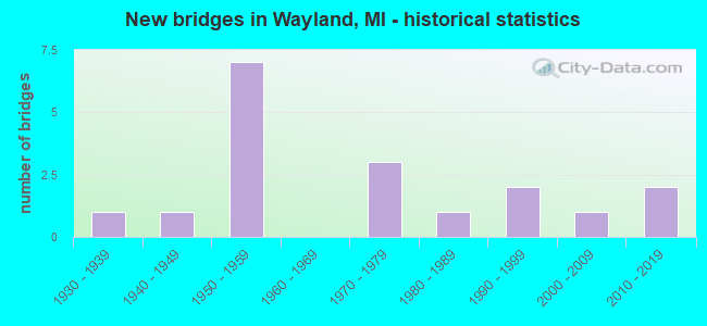
- New bridges - historical statistics
- 11930-1939
- 11940-1949
- 71950-1959
- 31970-1979
- 11980-1989
- 21990-1999
- 12000-2009
- 22010-2019


- Bridge Condition - Deck
- 9.1%Very good
- 27.3%Good
- 45.5%Satisfactory
- 9.1%Fair
- 9.1%Poor

- Bridge Condition - Superstructure
- 18.2%Very good
- 18.2%Good
- 18.2%Satisfactory
- 36.4%Fair
- 9.1%Poor

- Bridge Condition - Substructure
- 9.1%Very good
- 45.5%Good
- 27.3%Satisfactory
- 18.2%Fair

- Bridge Condition - Channel
- 75.0%Satisfactory
- 12.5%Fair
- 12.5%Serious

- Bridge Condition - Culverts
- 50.0%Poor
- 50.0%Serious
Find on map >> Show street view
Structure Number: 153, Location: 0.3 MI N OF WAYLAND (Lat: 42.683728, Lng: -85.660469), Route carried "on" structure: US 131, Year Built: 1957, Status: Open, Structure Length: 1.70m (5.58ft), Average Daily Traffic: 15,300 (year 2009), Truck Traffic: 10%, Average Future Daily Traffic: 24,415 (year 2018), Design Load: HS 20, Features Intersected: RABBIT RIVER
Minimum Vertical Clearance: 30.48m (100.00ft), Kilometerpoint: 29.397, Lanes on structure: 2, Base Highway Network: Yes (Inventory Route: 78, Subroute: 6), Owner: State Highway Agency, Approaching Roadway Width: 12.2m (40.0ft), Skew: 3 degrees, Material/Design: Steel, Design/Construction: Stringer/Multi-beam, Number Of Spans In Main Unit: 1, Length of Maximum Span: 17.0m (55.8ft), Curb-To-Curb Width: 12.8m (42.0ft), Out-to-Out Width: 14.4m (47.2ft)
Condition: Deck: Satisfactory, Superstructure: Fair, Substructure: Satisfactory, Channel: Satisfactory, Operating Rating: 83.3 metric tons, Method Used To Determine Operating Rating: Load Factor (LF), Inventory Rating: 49.9 metric tons, Method Used To Determine Inventory Rating: Load Factor (LF), Structural Evaluation: Somewhat better than minimum adequacy, Deck Geometry: Equal to present desirable criteria, Waterway Adequacy: Equal to present desirable criteria, Approach Roadway Alignment: Better than present minimum criteria, Designated Inspection Frequency: Every 24 months, Inspection Date: June 2021, Deck Structure Type: Concrete Cast-file-Place, Wearing Surface/Protective System: Wearing Surface: Latex Concrete
Find on map >> Show street view
Structure Number: 154, Location: 0.3 MI N OF WAYLAND (Lat: 42.683639, Lng: -85.660717), Route carried "on" structure: US 131, Year Built: 1957, Status: Open, Structure Length: 1.70m (5.58ft), Average Daily Traffic: 18,817 (year 2007), Truck Traffic: 14%, Average Future Daily Traffic: 24,415 (year 2018), Design Load: HS 20, Features Intersected: RABBIT RIVER
Minimum Vertical Clearance: 30.48m (100.00ft), Kilometerpoint: 29.388, Lanes on structure: 2, Base Highway Network: Yes (Inventory Route: 78, Subroute: 5), Owner: State Highway Agency, Approaching Roadway Width: 12.2m (40.0ft), Skew: 13 degrees, Material/Design: Steel, Design/Construction: Stringer/Multi-beam, Number Of Spans In Main Unit: 1, Length of Maximum Span: 17.0m (55.8ft), Curb-To-Curb Width: 12.8m (42.0ft), Out-to-Out Width: 14.4m (47.2ft)
Condition: Deck: Satisfactory, Superstructure: Fair, Substructure: Satisfactory, Channel: Satisfactory, Operating Rating: 83.3 metric tons, Method Used To Determine Operating Rating: Load Factor (LF), Inventory Rating: 49.8 metric tons, Method Used To Determine Inventory Rating: Load Factor (LF), Structural Evaluation: Somewhat better than minimum adequacy, Deck Geometry: Equal to present desirable criteria, Waterway Adequacy: Equal to present desirable criteria, Approach Roadway Alignment: Better than present minimum criteria, Designated Inspection Frequency: Every 24 months, Inspection Date: June 2021, Deck Structure Type: Concrete Cast-file-Place, Wearing Surface/Protective System: Wearing Surface: Latex Concrete
Find on map >> Show street view
Structure Number: 161, Location: 6.0 MI N OF M-222 (Lat: 42.630378, Lng: -85.662156), Route carried "on" structure: State highway 179, Year Built: 1959, Status: Open, Structure Length: 5.65m (18.54ft), Average Daily Traffic: 4,627 (year 2007), Truck Traffic: 5%, Average Future Daily Traffic: 6,476 (year 2018), Design Load: HS 20, Features Intersected: US-131
Minimum Vertical Clearance: 30.48m (100.00ft), Kilometerpoint: 0.866, Lanes on structure: 2, Lanes under structure: 4, Owner: State Highway Agency, Approaching Roadway Width: 8.8m (28.9ft), Material/Design: Prestressed concrete, Design/Construction: Stringer/Multi-beam, Number Of Spans In Main Unit: 4, Length of Maximum Span: 17.9m (58.7ft), Curb or Sidewalk Widths: Left: 0.2m (0.7ft), Right: 0.2m (0.7ft), Curb-To-Curb Width: 7.9m (25.9ft), Out-to-Out Width: 10.2m (33.5ft)
Condition: Deck: Poor, Superstructure: Poor, Substructure: Fair, Operating Rating: 59.9 metric tons, Method Used To Determine Operating Rating: Load Factor (LF) rating reported by rating factor (RF) method using MS18 loading, Inventory Rating: 36.0 metric tons, Method Used To Determine Inventory Rating: Load Factor (LF) rating reported by rating factor (RF) method using MS18 loading, Structural Evaluation: Meets minimum limits, Deck Geometry: High priority of corrective action, Underclear: Somewhat better than minimum adequacy, Approach Roadway Alignment: Equal to present minimum criteria, Designated Inspection Frequency: Every 12 months, Inspection Date: June 2021, Deck Structure Type: Concrete Cast-file-Place, Wearing Surface/Protective System: Wearing Surface: Bituminous, Membrane: Preformed Fabric
Find on map >> Show street view
Structure Number: 162, Location: AT W LTS OF WAYLAND (Lat: 42.674089, Lng: -85.661103), Route carried "on" structure: County highway 366, Year Built: 1999, Status: Open, Structure Length: 5.40m (17.72ft), Average Daily Traffic: 18,355 (year 1999), Truck Traffic: 13%, Average Future Daily Traffic: 21,100 (year 2020), Design Load: HS 25 or greater, Features Intersected: US-131, Facility Carried by Structure: 135TH AVE
Minimum Vertical Clearance: 30.48m (100.00ft), Kilometerpoint: 10.628, Lanes on structure: 3, Lanes under structure: 4, Owner: State Highway Agency, Approaching Roadway Width: 10.3m (33.8ft), Material/Design: Prestressed concrete, Design/Construction: Box Beam or Girders - Multiple, Number Of Spans In Main Unit: 2, Length of Maximum Span: 27.0m (88.6ft), Curb-To-Curb Width: 18.1m (59.4ft), Out-to-Out Width: 19.1m (62.7ft)
Condition: Deck: Satisfactory, Superstructure: Good, Substructure: Good, Operating Rating: 75.2 metric tons, Method Used To Determine Operating Rating: Load Factor (LF) rating reported by rating factor (RF) method using MS18 loading, Inventory Rating: 42.8 metric tons, Method Used To Determine Inventory Rating: Load Factor (LF) rating reported by rating factor (RF) method using MS18 loading, Structural Evaluation: Better than present minimum criteria, Deck Geometry: Superior to present desirable criteria, Underclear: Equal to present minimum criteria, Approach Roadway Alignment: Better than present minimum criteria, Designated Inspection Frequency: Every 24 months, Inspection Date: June 2021, Deck Structure Type: Concrete Cast-file-Place, Wearing Surface/Protective System: Wearing Surface: Monolithic Concrete, Deck Protection: Epoxy Coated Reinforcing
Find on map >> Show street view
Structure Number: 163, Location: 2.0 MI N OF WAYLAND (Lat: 42.710211, Lng: -85.661242), Route carried "on" structure: County highway , Year Built: 1957, Status: Open, Structure Length: 5.72m (18.77ft), Average Daily Traffic: 209 (year 1986), Truck Traffic: 2%, Average Future Daily Traffic: 240 (year 2006), Design Load: H 15, Features Intersected: US-131, Facility Carried by Structure: 140TH AVE
Minimum Vertical Clearance: 30.48m (100.00ft), Kilometerpoint: 7.410, Lanes on structure: 2, Lanes under structure: 4, Owner: State Highway Agency, Approaching Roadway Width: 8.5m (27.9ft), Skew: 2 degrees, Material/Design: Steel, Design/Construction: Stringer/Multi-beam, Number Of Spans In Main Unit: 4, Length of Maximum Span: 18.1m (59.4ft), Curb or Sidewalk Widths: Left: 0.2m (0.7ft), Right: 0.2m (0.7ft), Curb-To-Curb Width: 7.9m (25.9ft), Out-to-Out Width: 10.2m (33.5ft)
Condition: Deck: Fair, Superstructure: Fair, Substructure: Fair, Operating Rating: 54.1 metric tons, Method Used To Determine Operating Rating: Load Factor (LF) rating reported by rating factor (RF) method using MS18 loading, Inventory Rating: 29.2 metric tons, Method Used To Determine Inventory Rating: Load Factor (LF) rating reported by rating factor (RF) method using MS18 loading, Structural Evaluation: Somewhat better than minimum adequacy, Deck Geometry: Somewhat better than minimum adequacy, Underclear: Somewhat better than minimum adequacy, Approach Roadway Alignment: Equal to present desirable criteria, Designated Inspection Frequency: Every 24 months, Inspection Date: June 2021, Deck Structure Type: Concrete Cast-file-Place, Wearing Surface/Protective System: Wearing Surface: Monolithic Concrete
Find on map >> Show street view
Structure Number: 164, Location: 3.0 MI N OF WAYLAND (Lat: 42.724778, Lng: -85.672131), Route carried "on" structure: County highway 382, Year Built: 2011, Status: Open, Structure Length: 5.18m (16.99ft), Average Daily Traffic: 10,163 (year 1997), Truck Traffic: 2%, Average Future Daily Traffic: 8,550 (year 2030), Design Load: HL 93, Features Intersected: US-131, Facility Carried by Structure: 142ND AVE
Minimum Vertical Clearance: 30.48m (100.00ft), Kilometerpoint: 26.677, Lanes on structure: 3, Lanes under structure: 4, Owner: State Highway Agency, Approaching Roadway Width: 15.8m (51.8ft), Skew: 1 degrees, Material/Design: Prestressed concrete, Design/Construction: Box Beam or Girders - Multiple, Number Of Spans In Main Unit: 2, Length of Maximum Span: 25.9m (85.0ft), Curb-To-Curb Width: 15.5m (50.9ft), Out-to-Out Width: 16.4m (53.8ft)
Condition: Deck: Good, Superstructure: Good, Substructure: Good, Operating Rating: 94.3 metric tons, Method Used To Determine Operating Rating: Load and Resistance Factor Rating (LRFR) rating reported by rating factor(RF) method using HL-93 loadings, Inventory Rating: 72.9 metric tons, Method Used To Determine Inventory Rating: Load and Resistance Factor Rating (LRFR) rating reported by rating factor(RF) method using HL-93 loadings, Structural Evaluation: Better than present minimum criteria, Deck Geometry: Equal to present minimum criteria, Underclear: Superior to present desirable criteria, Approach Roadway Alignment: Better than present minimum criteria, Designated Inspection Frequency: Every 24 months, Inspection Date: June 2021, Deck Structure Type: Concrete Cast-file-Place, Wearing Surface/Protective System: Wearing Surface: Integral Concrete, Deck Protection: Epoxy Coated Reinforcing
Find on map >> Show street view
Structure Number: 21, Location: WAYLAND TWP SEC 29-30 (Lat: 42.610000, Lng: -85.642244), Route carried "on" structure: County highway 385, Year Built: 1939, Year Reconstructed: 2006, Status: Open, Structure Length: 4.59m (15.06ft), Average Daily Traffic: 2,222 (year 2016), Truck Traffic: 7%, Average Future Daily Traffic: 3,270 (year 2036), Design Load: HS 25 or greater, Features Intersected: CONSOLIDATED RAIL CORP, Facility Carried by Structure: 10TH STREET
Minimum Vertical Clearance: 30.48m (100.00ft), Kilometerpoint: 21.386, Lanes on structure: 2, Owner: County Highway Agency, Approaching Roadway Width: 11.0m (36.1ft), Skew: 4 degrees, Material/Design: Prestressed concrete, Design/Construction: Box Beam or Girders - Multiple, Number Of Spans In Main Unit: 3, Length of Maximum Span: 16.6m (54.5ft), Curb-To-Curb Width: 12.6m (41.3ft), Out-to-Out Width: 13.4m (44.0ft)
Condition: Deck: Good, Superstructure: Satisfactory, Substructure: Good, Operating Rating: 97.2 metric tons, Method Used To Determine Operating Rating: Load Factor (LF) rating reported by rating factor (RF) method using MS18 loading, Inventory Rating: 81.0 metric tons, Method Used To Determine Inventory Rating: Load Factor (LF) rating reported by rating factor (RF) method using MS18 loading, Structural Evaluation: Equal to present minimum criteria, Deck Geometry: Equal to present minimum criteria, Approach Roadway Alignment: Better than present minimum criteria, Designated Inspection Frequency: Every 24 months, Inspection Date: September 2021, Deck Structure Type: Concrete Cast-file-Place, Wearing Surface/Protective System: Wearing Surface: Epoxy Overlay, Deck Protection: Epoxy Coated Reinforcing
Find on map >> Show street view
Structure Number: 211, Location: APPROX 3/8 MI SE OF 137TH (Lat: 42.686008, Lng: -85.645947), Route carried "on" structure: County highway 385, Year Built: 1940, Status: Open, Structure Length: 1.00m (3.28ft), Average Daily Traffic: 3,443 (year 2013), Truck Traffic: 7%, Average Future Daily Traffic: 3,615 (year 2033), Design Load: HS 20+Mod, Features Intersected: RABBIT RIVER, Facility Carried by Structure: DIVISION STREET
Minimum Vertical Clearance: 30.48m (100.00ft), Kilometerpoint: 0.425, Lanes on structure: 2, Owner: County Highway Agency, Approaching Roadway Width: 10.7m (35.1ft), Skew: 4 degrees, Material/Design: Concrete, Design/Construction: Tee Beam, Number Of Spans In Main Unit: 1, Length of Maximum Span: 9.7m (31.8ft), Curb-To-Curb Width: 10.7m (35.1ft), Out-to-Out Width: 11.7m (38.4ft)
Condition: Deck: Satisfactory, Superstructure: Fair, Substructure: Good, Channel: Satisfactory, Operating Rating: 51.3 metric tons, Method Used To Determine Operating Rating: Field evaluation and documented engineering judgment, Inventory Rating: 30.7 metric tons, Method Used To Determine Inventory Rating: Field evaluation and documented engineering judgment, Structural Evaluation: Somewhat better than minimum adequacy, Deck Geometry: Somewhat better than minimum adequacy, Waterway Adequacy: Equal to present minimum criteria, Approach Roadway Alignment: Better than present minimum criteria, Designated Inspection Frequency: Every 24 months, Inspection Date: October 2021, Deck Structure Type: Concrete Cast-file-Place, Wearing Surface/Protective System: Wearing Surface: Bituminous
Find on map >> Show street view
Structure Number: 23, Location: APPROX 0.15 MI W OF 12TH (Lat: 42.681153, Lng: -85.664503), Route carried "on" structure: County highway , Year Built: 1971, Status: Open, Structure Length: 1.22m (4.00ft), Average Daily Traffic: 112 (year 2002), Truck Traffic: 7%, Average Future Daily Traffic: 224 (year 2022), Design Load: HS 20+Mod, Features Intersected: RABBIT RIVER, Facility Carried by Structure: 136TH AVE
Minimum Vertical Clearance: 30+ m (98+ ft), Kilometerpoint: 6.290, Lanes on structure: 2, Owner: County Highway Agency, Approaching Roadway Width: 9.1m (29.9ft), Material/Design: Wood or Timber, Design/Construction: Slab, Number Of Spans In Main Unit: 2, Length of Maximum Span: 6.1m (20.0ft), Curb-To-Curb Width: 8.5m (27.9ft), Out-to-Out Width: 8.9m (29.2ft)
Condition: Deck: Satisfactory, Superstructure: Satisfactory, Substructure: Satisfactory, Channel: Fair, Operating Rating: 53.8 metric tons, Method Used To Determine Operating Rating: Allowable Stress (AS) rating reported by rating factor (RF) method using MS18 loading, Inventory Rating: 38.6 metric tons, Method Used To Determine Inventory Rating: Allowable Stress (AS) rating reported by rating factor (RF) method using MS18 loading, Structural Evaluation: Equal to present minimum criteria, Deck Geometry: Equal to present minimum criteria, Waterway Adequacy: Equal to present desirable criteria, Approach Roadway Alignment: Equal to present desirable criteria, Designated Inspection Frequency: Every 24 months, Inspection Date: April 2021, Deck Structure Type: Wood or Timber, Wearing Surface/Protective System: Wearing Surface: Bituminous
Find on map >> Show street view
Structure Number: 24, Location: APPROX 1/8MI N OF 140TH A (Lat: 42.712061, Lng: -85.702036), Route carried "on" structure: County highway , Year Built: 1974, Status: Posted for load, Structure Length: 0.94m (3.08ft), Average Daily Traffic: 436 (year 2002), Truck Traffic: 7%, Average Future Daily Traffic: 872 (year 2022), Design Load: H 20, Features Intersected: RED RUN DRAIN, Facility Carried by Structure: 16TH STREET
Minimum Vertical Clearance: 30.48m (100.00ft), Kilometerpoint: 11.456, Lanes on structure: 2, Owner: County Highway Agency, Approaching Roadway Width: 7.6m (24.9ft), Skew: 4 degrees, Material/Design: Steel, Design/Construction: Culvert, Number Of Spans In Main Unit: 2, Length of Maximum Span: 3.9m (12.8ft)
Condition: Channel: Serious, Culverts: Serious, Operating Rating: 22.4 metric tons, Method Used To Determine Operating Rating: Load Factor (LF) rating reported by rating factor (RF) method using MS18 loading, Inventory Rating: 13.6 metric tons, Method Used To Determine Inventory Rating: Load Factor (LF) rating reported by rating factor (RF) method using MS18 loading, Structural Evaluation: High priority of corrective action, Waterway Adequacy: Equal to present minimum criteria, Approach Roadway Alignment: Equal to present desirable criteria, Bridge Posting: Required (Relationship of Operating Rating to Maximum Legal Load: > 39.9% below), Designated Inspection Frequency: Every 12 months, Inspection Date: April 2021
Find on map >> Show street view
Structure Number: 261, Location: HOPKINS TWP SEC 10-11 (Lat: 42.656253, Lng: -85.702336), Route carried "on" structure: County highway , Year Built: 1982, Status: Open, Structure Length: 1.43m (4.69ft), Average Daily Traffic: 120 (year 2015), Truck Traffic: 7%, Average Future Daily Traffic: 178 (year 2035), Design Load: HS 20+Mod, Features Intersected: RABBIT RIVER, Facility Carried by Structure: 16TH STREET
Minimum Vertical Clearance: 30.48m (100.00ft), Kilometerpoint: 5.221, Lanes on structure: 2, Owner: County Highway Agency, Approaching Roadway Width: 9.1m (29.9ft), Skew: 1 degrees, Material/Design: Prestressed concrete, Design/Construction: Box Beam or Girders - Multiple, Number Of Spans In Main Unit: 1, Length of Maximum Span: 14.3m (46.9ft), Curb-To-Curb Width: 8.9m (29.2ft), Out-to-Out Width: 9.3m (30.5ft)
Condition: Deck: Very good, Superstructure: Very good, Substructure: Good, Channel: Satisfactory, Operating Rating: 58.6 metric tons, Method Used To Determine Operating Rating: Load Factor (LF) rating reported by rating factor (RF) method using MS18 loading, Inventory Rating: 35.0 metric tons, Method Used To Determine Inventory Rating: Load Factor (LF) rating reported by rating factor (RF) method using MS18 loading, Structural Evaluation: Better than present minimum criteria, Deck Geometry: Equal to present minimum criteria, Waterway Adequacy: Better than present minimum criteria, Approach Roadway Alignment: Equal to present desirable criteria, Designated Inspection Frequency: Every 24 months, Inspection Date: May 2021, Deck Structure Type: Concrete Precast Panels, Wearing Surface/Protective System: Wearing Surface: Bituminous, Membrane: Preformed Fabric
Find on map >> Show street view
Structure Number: 273, Location: LEIGHTON TWP SEC 31-32 (Lat: 42.685681, Lng: -85.643586), Route carried "on" structure: County highway , Year Built: 2009, Status: Open, Structure Length: 1.37m (4.49ft), Average Daily Traffic: 1,271 (year 2007), Truck Traffic: 5%, Average Future Daily Traffic: 2,091 (year 2028), Features Intersected: RABBIT RIVER DRAIN, Facility Carried by Structure: 10TH STREET
Minimum Vertical Clearance: 30.48m (100.00ft), Kilometerpoint: 29.827, Lanes on structure: 2, Owner: County Highway Agency, Approaching Roadway Width: 12.2m (40.0ft), Skew: 1 degrees, Material/Design: Prestressed concrete, Design/Construction: Box Beam or Girders - Single/Spread, Number Of Spans In Main Unit: 1, Length of Maximum Span: 12.5m (41.0ft), Curb-To-Curb Width: 12.2m (40.0ft), Out-to-Out Width: 13.1m (43.0ft)
Condition: Deck: Good, Superstructure: Very good, Substructure: Very good, Channel: Satisfactory, Operating Rating: 97.2 metric tons, Method Used To Determine Operating Rating: Load Factor (LF) rating reported by rating factor (RF) method using MS18 loading, Inventory Rating: 70.0 metric tons, Method Used To Determine Inventory Rating: Load Factor (LF) rating reported by rating factor (RF) method using MS18 loading, Structural Evaluation: Equal to present desirable criteria, Deck Geometry: Better than present minimum criteria, Waterway Adequacy: Equal to present desirable criteria, Approach Roadway Alignment: Equal to present desirable criteria, Designated Inspection Frequency: Every 24 months, Inspection Date: April 2021, Deck Structure Type: Concrete Cast-file-Place, Wearing Surface/Protective System: Wearing Surface: Monolithic Concrete, Deck Protection: Epoxy Coated Reinforcing
Find on map >> Show street view
Structure Number: 312, Location: APPROX 3/8MI S OF 135TH A (Lat: 42.668650, Lng: -85.613700), Route carried "on" structure: County highway , Year Built: 1971, Status: Posted for load, Structure Length: 0.64m (2.10ft), Average Daily Traffic: 300 (year 2002), Truck Traffic: 7%, Average Future Daily Traffic: 600 (year 2002), Design Load: H 20, Features Intersected: RABBIT RIVER, Facility Carried by Structure: 7TH STREET
Minimum Vertical Clearance: 30.48m (100.00ft), Kilometerpoint: 0.636, Lanes on structure: 2, Owner: County Highway Agency, Approaching Roadway Width: 9.1m (29.9ft), Skew: 1 degrees, Material/Design: Steel, Design/Construction: Culvert, Number Of Spans In Main Unit: 2, Length of Maximum Span: 2.4m (7.9ft)
Condition: Channel: Satisfactory, Culverts: Poor, Operating Rating: 23.3 metric tons, Method Used To Determine Operating Rating: Load Factor (LF) rating reported by rating factor (RF) method using MS18 loading, Inventory Rating: 13.9 metric tons, Method Used To Determine Inventory Rating: Load Factor (LF) rating reported by rating factor (RF) method using MS18 loading, Structural Evaluation: Meets minimum limits, Waterway Adequacy: Equal to present minimum criteria, Approach Roadway Alignment: Equal to present desirable criteria, Designated Inspection Frequency: Every 24 months, Inspection Date: April 2021
Find on map >> Show street view
Structure Number: 161, Location: 6.0 MI N OF M-222 (Lat: 42.630378, Lng: -85.662156), Route carried "under" structure: US 131, Year Built: 1959, Structure Length: 0. m, Average Daily Traffic: 30,438 (year 2007), Truck Traffic: 16%, Features Intersected: US-131, Facility Carried by Structure: M-179 (129TH AVE)
Minimum Vertical Clearance: 4.62m (15.16ft), Kilometerpoint: 23.468, Lanes on structure: 2, Lanes under structure: 4, Material/Design: Prestressed concrete, Design/Construction: Stringer/Multi-beam, Length of Maximum Span: 17.9m (58.7ft)
Find on map >> Show street view
Structure Number: 162, Location: AT W LTS OF WAYLAND (Lat: 42.674089, Lng: -85.661103), Route carried "under" structure: US 131, Year Built: 1999, Structure Length: 0. m, Average Daily Traffic: 37,634 (year 2007), Truck Traffic: 14%, Features Intersected: US-131, Facility Carried by Structure: 135TH AVE
Minimum Vertical Clearance: 4.98m (16.34ft), Kilometerpoint: 28.325, Lanes on structure: 3, Lanes under structure: 4, Material/Design: Prestressed concrete, Design/Construction: Box Beam or Girders - Multiple, Length of Maximum Span: 27.0m (88.6ft)
Find on map >> Show street view
Structure Number: 163, Location: 2.0 MI N OF WAYLAND (Lat: 42.710211, Lng: -85.661242), Route carried "under" structure: US 131, Year Built: 1957, Structure Length: 0. m, Average Daily Traffic: 37,634 (year 2007), Truck Traffic: 14%, Features Intersected: US-131, Facility Carried by Structure: 140TH AVE
Minimum Vertical Clearance: 4.82m (15.81ft), Kilometerpoint: 32.363, Lanes on structure: 2, Lanes under structure: 4, Material/Design: Steel, Design/Construction: Stringer/Multi-beam, Length of Maximum Span: 18.1m (59.4ft)
Find on map >> Show street view
Structure Number: 164, Location: 3.0 MI N OF WAYLAND (Lat: 42.724778, Lng: -85.672131), Route carried "under" structure: US 131, Year Built: 2011, Structure Length: 0. m, Average Daily Traffic: 37,634 (year 2007), Truck Traffic: 13%, Features Intersected: US-131, Facility Carried by Structure: 142ND AVE
Minimum Vertical Clearance: 6.17m (20.24ft), Kilometerpoint: 34.214, Lanes on structure: 3, Lanes under structure: 4, Material/Design: Prestressed concrete, Design/Construction: Box Beam or Girders - Multiple, Length of Maximum Span: 25.9m (85.0ft)
Find on map >> Show street view
Structure Number: 165, Location: 4.1 MI N OF WAYLAND (Lat: 42.739336, Lng: -85.673183), Route carried "under" structure: US 131, Year Built: 1957, Structure Length: 0. m, Average Daily Traffic: 36,752 (year 2007), Truck Traffic: 13%, Features Intersected: US-131, Facility Carried by Structure: 144TH AVE
Minimum Vertical Clearance: 4.55m (14.93ft), Kilometerpoint: 35.840, Lanes on structure: 2, Lanes under structure: 4, Material/Design: Steel, Design/Construction: Stringer/Multi-beam, Length of Maximum Span: 16.3m (53.5ft)