Bridge Statistics for Waverly, Pennsylvania (PA)
Condition, Traffic, Stress, Structural Evaluation, Project Costs
- National Bridge Inventory (NBI) Statistics
- 22Number of bridges
- 131ft / 40.0mTotal length
- $5,332,000Total costs
- 74,783Total average daily traffic
- 15,208Total average daily truck traffic
- National Bridge Inventory (NBI) Registered Bridges for Waverly
- No street view available for this location
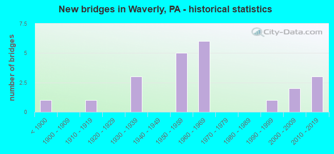
- New bridges - historical statistics
- 1Before 1900
- 11910-1919
- 31930-1939
- 51950-1959
- 61960-1969
- 11990-1999
- 22000-2009
- 32010-2019

- Reconstructed bridges - Historical Statistics
- 11950-1959
- 01960-1969
- 11970-1979
- 41980-1989
- 21990-1999
- 12000-2009
- 12010-2019


- Bridge Condition - Deck
- 30.8%Very good
- 38.5%Good
- 23.1%Satisfactory
- 7.7%Poor

- Bridge Condition - Superstructure
- 31.3%Very good
- 18.8%Good
- 12.5%Satisfactory
- 31.3%Fair
- 6.3%Poor

- Bridge Condition - Substructure
- 25.0%Very good
- 12.5%Good
- 37.5%Satisfactory
- 12.5%Fair
- 12.5%Poor

- Bridge Condition - Channel
- 20.0%Very good
- 13.3%Good
- 26.7%Satisfactory
- 26.7%Fair
- 13.3%Poor

- Bridge Condition - Culverts
- 50.0%Good
- 50.0%Serious
Find on map >> Show street view
Structure Number: 20478, Location: SCOTT TWP OVER TR 524 (Lat: 41.553625, Lng: -75.652153), Route carried "on" structure: Interstate 81, Year Built: 1959, Year Reconstructed: 1985, Status: Open, Structure Length: 3.51m (11.52ft), Average Daily Traffic: 12,321 (year 2021), Truck Traffic: 31%, Average Future Daily Traffic: 18,084 (year 2032), Design Load: HS 20+Mod, Features Intersected: SR 0524 TR 524 EXIT 199
Minimum Vertical Clearance: 30+ m (98+ ft), Kilometerpoint: 32.425, Lanes on structure: 2, Lanes under structure: 2, Base Highway Network: Yes, Owner: State Highway Agency, Approaching Roadway Width: 11.9m (39.0ft), Skew: 12 degrees, Material/Design: Prestressed concrete, Design/Construction: Stringer/Multi-beam, Number Of Spans In Main Unit: 3, Length of Maximum Span: 14.0m (45.9ft), Curb or Sidewalk Widths: Left: 0.2m (0.7ft), Right: 0.2m (0.7ft), Curb-To-Curb Width: 12.9m (42.3ft), Out-to-Out Width: 13.9m (45.6ft)
Condition: Deck: Good, Superstructure: Fair, Substructure: Satisfactory, Operating Rating: 80.7 metric tons, Method Used To Determine Operating Rating: Load Factor (LF), Inventory Rating: 32.7 metric tons, Method Used To Determine Inventory Rating: Load Factor (LF), Structural Evaluation: Somewhat better than minimum adequacy, Deck Geometry: Superior to present desirable criteria, Underclear: Meets minimum limits, Approach Roadway Alignment: Equal to present desirable criteria, Length Of Structure Improvement: 3.40m (11.15ft), Designated Inspection Frequency: Every 24 months, Inspection Date: October 2020, Bridge Improvement Cost: $38,000, Roadway Improvement Cost: $112,000, Total Project Cost: $513,000, Deck Structure Type: Concrete Cast-file-Place, Wearing Surface/Protective System: Wearing Surface: Latex Concrete, Deck Protection: Epoxy Coated Reinforcing
Find on map >> Show street view
Structure Number: 20479, Location: SCOTT TWP OVER TR 524 (Lat: 41.553567, Lng: -75.652458), Route carried "on" structure: Interstate 81, Year Built: 1959, Year Reconstructed: 1986, Status: Open, Structure Length: 3.51m (11.52ft), Average Daily Traffic: 13,317 (year 2021), Truck Traffic: 25%, Average Future Daily Traffic: 17,632 (year 2032), Design Load: HS 20+Mod, Features Intersected: SR 0524 TR 524 EXIT 199
Minimum Vertical Clearance: 30+ m (98+ ft), Kilometerpoint: 32.541, Lanes on structure: 2, Lanes under structure: 2, Base Highway Network: Yes, Owner: State Highway Agency, Approaching Roadway Width: 12.5m (41.0ft), Skew: 12 degrees, Material/Design: Prestressed concrete, Design/Construction: Stringer/Multi-beam, Number Of Spans In Main Unit: 3, Length of Maximum Span: 14.0m (45.9ft), Curb or Sidewalk Widths: Left: 0.2m (0.7ft), Right: 0.2m (0.7ft), Curb-To-Curb Width: 13.0m (42.7ft), Out-to-Out Width: 13.9m (45.6ft)
Condition: Deck: Good, Superstructure: Fair, Substructure: Satisfactory, Operating Rating: 80.7 metric tons, Method Used To Determine Operating Rating: Load Factor (LF), Inventory Rating: 32.7 metric tons, Method Used To Determine Inventory Rating: Load Factor (LF), Structural Evaluation: Somewhat better than minimum adequacy, Deck Geometry: Superior to present desirable criteria, Underclear: Meets minimum limits, Approach Roadway Alignment: Equal to present desirable criteria, Length Of Structure Improvement: 3.40m (11.15ft), Designated Inspection Frequency: Every 24 months, Inspection Date: October 2020, Bridge Improvement Cost: $42,000, Roadway Improvement Cost: $125,000, Total Project Cost: $572,000, Deck Structure Type: Concrete Cast-file-Place, Wearing Surface/Protective System: Wearing Surface: Monolithic Concrete, Deck Protection: Epoxy Coated Reinforcing
Find on map >> Show street view
Structure Number: 20481, Location: SCOTT TWP OVER TR 438 (Lat: 41.576772, Lng: -75.653708), Route carried "on" structure: Interstate 81, Year Built: 1961, Year Reconstructed: 1985, Status: Open, Structure Length: 7.25m (23.79ft), Average Daily Traffic: 11,732 (year 2021), Truck Traffic: 25%, Average Future Daily Traffic: 14,403 (year 2032), Design Load: HS 20+Mod, Features Intersected: TR 438 & TUNKHANNOCK CK
Minimum Vertical Clearance: 30+ m (98+ ft), Kilometerpoint: 34.834, Lanes on structure: 3, Lanes under structure: 2, Base Highway Network: Yes, Owner: State Highway Agency, Approaching Roadway Width: 11.6m (38.1ft), Skew: 11 degrees, Material/Design: Prestressed concrete, Design/Construction: Box Beam or Girders - Multiple, Number Of Spans In Main Unit: 4, Length of Maximum Span: 23.2m (76.1ft), Curb or Sidewalk Widths: Left: 0.2m (0.7ft), Right: 0.2m (0.7ft), Curb-To-Curb Width: 14.0m (45.9ft), Out-to-Out Width: 15.4m (50.5ft)
Condition: Deck: Very good, Superstructure: Fair, Substructure: Good, Channel: Very good, Operating Rating: 97.1 metric tons, Method Used To Determine Operating Rating: Load Factor (LF), Inventory Rating: 48.1 metric tons, Method Used To Determine Inventory Rating: Load Factor (LF), Structural Evaluation: Somewhat better than minimum adequacy, Deck Geometry: Meets minimum limits, Underclear: Meets minimum limits, Waterway Adequacy: Superior to present desirable criteria, Approach Roadway Alignment: Equal to present desirable criteria, Length Of Structure Improvement: 7.20m (23.62ft), Designated Inspection Frequency: Every 24 months, Inspection Date: October 2020, Bridge Improvement Cost: $65,000, Roadway Improvement Cost: $190,000, Total Project Cost: $873,000, Deck Structure Type: Concrete Cast-file-Place, Wearing Surface/Protective System: Wearing Surface: Latex Concrete, Deck Protection: Epoxy Coated Reinforcing
Find on map >> Show street view
Structure Number: 20482, Location: SCOTT TWP OVER TR 438 (Lat: 41.576569, Lng: -75.654625), Route carried "on" structure: Interstate 81, Year Built: 1961, Year Reconstructed: 1985, Status: Open, Structure Length: 7.65m (25.10ft), Average Daily Traffic: 13,317 (year 2021), Truck Traffic: 25%, Average Future Daily Traffic: 17,632 (year 2032), Design Load: HS 20+Mod, Features Intersected: TR 438 & TUNKHNOCK CREEK
Minimum Vertical Clearance: 30+ m (98+ ft), Kilometerpoint: 34.965, Lanes on structure: 3, Lanes under structure: 2, Base Highway Network: Yes, Owner: State Highway Agency, Approaching Roadway Width: 11.9m (39.0ft), Skew: 11 degrees, Material/Design: Prestressed concrete, Design/Construction: Box Beam or Girders - Multiple, Number Of Spans In Main Unit: 4, Length of Maximum Span: 26.8m (87.9ft), Curb or Sidewalk Widths: Left: 0.2m (0.7ft), Right: 0.2m (0.7ft), Curb-To-Curb Width: 14.0m (45.9ft), Out-to-Out Width: 15.1m (49.5ft)
Condition: Deck: Very good, Superstructure: Fair, Substructure: Satisfactory, Channel: Very good, Operating Rating: 81.6 metric tons, Method Used To Determine Operating Rating: Load Factor (LF), Inventory Rating: 38.1 metric tons, Method Used To Determine Inventory Rating: Load Factor (LF), Structural Evaluation: Somewhat better than minimum adequacy, Deck Geometry: Meets minimum limits, Underclear: Meets minimum limits, Waterway Adequacy: Superior to present desirable criteria, Approach Roadway Alignment: Equal to present desirable criteria, Length Of Structure Improvement: 7.60m (24.93ft), Designated Inspection Frequency: Every 24 months, Inspection Date: October 2020, Bridge Improvement Cost: $89,000, Roadway Improvement Cost: $261,000, Total Project Cost: $1,196,000, Deck Structure Type: Concrete Cast-file-Place, Wearing Surface/Protective System: Wearing Surface: Latex Concrete, Deck Protection: Epoxy Coated Reinforcing
Find on map >> Show street view
Structure Number: 20581, Location: SCOTT TWP .8 M N TR 632 (Lat: 41.543450, Lng: -75.647222), Route carried "on" structure: State highway 347, Year Built: 1938, Year Reconstructed: 1955, Status: Open, Structure Length: 0.64m (2.10ft), Average Daily Traffic: 789 (year 2022), Truck Traffic: 4%, Average Future Daily Traffic: 1,074 (year 2032), Design Load: H 20, Features Intersected: KENNEDY CREEK
Minimum Vertical Clearance: 30+ m (98+ ft), Kilometerpoint: 16.409, Lanes on structure: 2, Owner: State Highway Agency, Approaching Roadway Width: 6.1m (20.0ft), Skew: 3 degrees, Material/Design: Steel, Design/Construction: Stringer/Multi-beam, Number Of Spans In Main Unit: 1, Length of Maximum Span: 6.1m (20.0ft), Curb or Sidewalk Widths: Left: 0.2m (0.7ft), Right: 0.2m (0.7ft), Curb-To-Curb Width: 7.1m (23.3ft), Out-to-Out Width: 8.0m (26.2ft)
Condition: Deck: Satisfactory, Superstructure: Fair, Substructure: Satisfactory, Channel: Poor, Operating Rating: 47.2 metric tons, Method Used To Determine Operating Rating: Load Factor (LF), Inventory Rating: 28.1 metric tons, Method Used To Determine Inventory Rating: Load Factor (LF), Structural Evaluation: Somewhat better than minimum adequacy, Deck Geometry: Meets minimum limits, Waterway Adequacy: Better than present minimum criteria, Approach Roadway Alignment: Equal to present minimum criteria, Length Of Structure Improvement: 0.70m (2.30ft), Designated Inspection Frequency: Every 24 months, Inspection Date: July 2020, Bridge Improvement Cost: $17,000, Roadway Improvement Cost: $98,000, Total Project Cost: $232,000, Deck Structure Type: Concrete Cast-file-Place, Wearing Surface/Protective System: Wearing Surface: Bituminous
Find on map >> Show street view
Structure Number: 20626, Location: BENTON TWP 1.2 M E TR 407 (Lat: 41.583294, Lng: -75.691156), Route carried "on" structure: State highway 438, Year Built: 1990, Status: Open, Structure Length: 0.88m (2.89ft), Average Daily Traffic: 477 (year 2022), Truck Traffic: 9%, Average Future Daily Traffic: 362 (year 2032), Design Load: HS 25 or greater, Features Intersected: BR TUNKHANNOCK CREEK
Minimum Vertical Clearance: 30+ m (98+ ft), Kilometerpoint: 6.637, Lanes on structure: 2, Owner: State Highway Agency, Approaching Roadway Width: 7.3m (24.0ft), Skew: 3 degrees, Material/Design: Prestressed concrete, Design/Construction: Slab, Number Of Spans In Main Unit: 1, Length of Maximum Span: 8.2m (26.9ft), Curb or Sidewalk Widths: Left: 0.2m (0.7ft), Right: 0.2m (0.7ft), Curb-To-Curb Width: 10.0m (32.8ft), Out-to-Out Width: 11.1m (36.4ft)
Condition: Deck: Good, Superstructure: Good, Substructure: Satisfactory, Channel: Fair, Inventory Rating: 67.1 metric tons, Method Used To Determine Inventory Rating: Load Factor (LF), Structural Evaluation: Equal to present minimum criteria, Deck Geometry: Equal to present minimum criteria, Waterway Adequacy: Equal to present desirable criteria, Approach Roadway Alignment: Better than present minimum criteria, Length Of Structure Improvement: 1.60m (5.25ft), Designated Inspection Frequency: Every 48 months, Inspection Date: August 2020, Deck Structure Type: Concrete Cast-file-Place, Wearing Surface/Protective System: Wearing Surface: Epoxy Overlay, Deck Protection: Epoxy Coated Reinforcing
Find on map >> Show street view
Structure Number: 20629, Location: SCOTT TWP .5 M E I-81 (Lat: 41.574958, Lng: -75.641981), Route carried "on" structure: State highway 438, Year Built: 1931, Year Reconstructed: 1983, Status: Open, Structure Length: 2.38m (7.81ft), Average Daily Traffic: 949 (year 2021), Truck Traffic: 7%, Average Future Daily Traffic: 981 (year 2032), Design Load: H 20, Features Intersected: SOUTH BR TUNKHANNOCK CRK
Minimum Vertical Clearance: 30+ m (98+ ft), Kilometerpoint: 10.416, Lanes on structure: 2, Owner: State Highway Agency, Approaching Roadway Width: 7.9m (25.9ft), Skew: 3 degrees, Material/Design: Prestressed concrete, Design/Construction: Box Beam or Girders - Multiple, Number Of Spans In Main Unit: 2, Length of Maximum Span: 11.6m (38.1ft), Curb or Sidewalk Widths: Left: 0.2m (0.7ft), Right: 0.2m (0.7ft), Curb-To-Curb Width: 9.1m (29.9ft), Out-to-Out Width: 10.2m (33.5ft)
Condition: Deck: Satisfactory, Superstructure: Good, Substructure: Poor, Channel: Fair, Operating Rating: 89.8 metric tons, Method Used To Determine Operating Rating: Load Factor (LF), Inventory Rating: 40.8 metric tons, Method Used To Determine Inventory Rating: Load Factor (LF), Structural Evaluation: Meets minimum limits, Deck Geometry: Equal to present minimum criteria, Waterway Adequacy: Superior to present desirable criteria, Approach Roadway Alignment: Equal to present desirable criteria, Length Of Structure Improvement: 2.40m (7.87ft), Designated Inspection Frequency: Every 24 months, Inspection Date: July 2020, Bridge Improvement Cost: $13,000, Roadway Improvement Cost: $100,000, Total Project Cost: $172,000, Deck Structure Type: Concrete Cast-file-Place, Wearing Surface/Protective System: Wearing Surface: Epoxy Overlay, Deck Protection: Epoxy Coated Reinforcing
Find on map >> Show street view
Structure Number: 20644, Location: N ABINGTON TP .5M E TR407 (Lat: 41.565339, Lng: -75.700092), Route carried "on" structure: State highway 524, Year Built: 1939, Year Reconstructed: 2015, Status: Open, Structure Length: 1.01m (3.31ft), Average Daily Traffic: 541 (year 2021), Truck Traffic: 6%, Average Future Daily Traffic: 801 (year 2032), Design Load: HL 93, Features Intersected: KENNEDY CREEK
Minimum Vertical Clearance: 30+ m (98+ ft), Kilometerpoint: 0.000, Lanes on structure: 2, Owner: State Highway Agency, Approaching Roadway Width: 6.4m (21.0ft), Skew: 3 degrees, Material/Design: Steel, Design/Construction: Stringer/Multi-beam, Number Of Spans In Main Unit: 1, Length of Maximum Span: 8.5m (27.9ft), Curb-To-Curb Width: 7.1m (23.3ft), Out-to-Out Width: 7.6m (24.9ft)
Condition: Deck: Very good, Superstructure: Very good, Substructure: Good, Channel: Very good, Operating Rating: 96.2 metric tons, Method Used To Determine Operating Rating: Load and Resistance Factor (LRFR), Inventory Rating: 73.5 metric tons, Method Used To Determine Inventory Rating: Load and Resistance Factor (LRFR), Structural Evaluation: Better than present minimum criteria, Deck Geometry: Meets minimum limits, Waterway Adequacy: Equal to present desirable criteria, Approach Roadway Alignment: Equal to present minimum criteria, Length Of Structure Improvement: 1.00m (3.28ft), Designated Inspection Frequency: Every 24 months, Inspection Date: October 2021, Bridge Improvement Cost: $12,000, Roadway Improvement Cost: $100,000, Total Project Cost: $162,000, Deck Structure Type: Concrete Cast-file-Place, Wearing Surface/Protective System: Wearing Surface: Monolithic Concrete, Deck Protection: Epoxy Coated Reinforcing
Find on map >> Show street view
Structure Number: 20792, Location: SCOTT TWP 400' S TR 438 (Lat: 41.575458, Lng: -75.655544), Route carried "on" structure: State highway , Year Built: 1959, Status: Open, Structure Length: 1.37m (4.49ft), Average Daily Traffic: 288 (year 2020), Truck Traffic: 7%, Average Future Daily Traffic: 292 (year 2032), Design Load: HS 20, Features Intersected: S BR TUNK CREEK, Facility Carried by Structure: SR 4003
Minimum Vertical Clearance: 30+ m (98+ ft), Kilometerpoint: 2.449, Lanes on structure: 2, Owner: State Highway Agency, Approaching Roadway Width: 7.0m (23.0ft), Skew: 1 degrees, Material/Design: Concrete, Design/Construction: Tee Beam, Number Of Spans In Main Unit: 1, Length of Maximum Span: 13.4m (44.0ft), Curb or Sidewalk Widths: Left: 0.5m (1.6ft), Right: 0.5m (1.6ft), Curb-To-Curb Width: 9.3m (30.5ft), Out-to-Out Width: 10.8m (35.4ft)
Condition: Deck: Poor, Superstructure: Poor, Substructure: Fair, Channel: Satisfactory, Operating Rating: 41.7 metric tons, Method Used To Determine Operating Rating: Load Factor (LF), Inventory Rating: 24.5 metric tons, Method Used To Determine Inventory Rating: Load Factor (LF), Structural Evaluation: Meets minimum limits, Deck Geometry: Equal to present minimum criteria, Waterway Adequacy: Superior to present desirable criteria, Approach Roadway Alignment: Equal to present minimum criteria, Length Of Structure Improvement: 1.40m (4.59ft), Designated Inspection Frequency: Every 24 months, Inspection Date: August 2020, Bridge Improvement Cost: $18,000, Roadway Improvement Cost: $100,000, Total Project Cost: $244,000, Deck Structure Type: Concrete Cast-file-Place, Wearing Surface/Protective System: Wearing Surface: Bituminous
Find on map >> Show street view
Structure Number: 20798, Location: N ABNGTN TP 200' S TR 524 (Lat: 41.555056, Lng: -75.664739), Route carried "on" structure: State highway , Year Built: 1962, Status: Open, Structure Length: 0.73m (2.40ft), Average Daily Traffic: 379 (year 2020), Truck Traffic: 9%, Average Future Daily Traffic: 589 (year 2032), Design Load: HS 20, Features Intersected: KENNEDY CREEK, Facility Carried by Structure: SR 4007 CRAIG ROAD
Minimum Vertical Clearance: 30+ m (98+ ft), Kilometerpoint: 5.510, Lanes on structure: 2, Owner: State Highway Agency, Approaching Roadway Width: 7.3m (24.0ft), Skew: 2 degrees, Material/Design: Concrete, Design/Construction: Slab, Number Of Spans In Main Unit: 1, Length of Maximum Span: 6.7m (22.0ft)
Condition: Superstructure: Good, Substructure: Satisfactory, Channel: Fair, Operating Rating: 66.2 metric tons, Method Used To Determine Operating Rating: Load Factor (LF), Inventory Rating: 39.9 metric tons, Method Used To Determine Inventory Rating: Load Factor (LF), Structural Evaluation: Equal to present minimum criteria, Waterway Adequacy: Equal to present desirable criteria, Approach Roadway Alignment: Equal to present desirable criteria, Length Of Structure Improvement: 1.40m (4.59ft), Designated Inspection Frequency: Every 24 months, Inspection Date: August 2020
Find on map >> Show street view
Structure Number: 20813, Location: GLENBURN TWP .5 M E TR 6 (Lat: 41.522472, Lng: -75.715450), Route carried "on" structure: State highway , Year Built: 1913, Year Reconstructed: 2012, Status: Open, Structure Length: 1.83m (6.00ft), Average Daily Traffic: 902 (year 2022), Truck Traffic: 5%, Average Future Daily Traffic: 1,532 (year 2032), Features Intersected: N.S. RR, Facility Carried by Structure: SR 4012 WAVERLY RD
Minimum Vertical Clearance: 30+ m (98+ ft), Kilometerpoint: 0.000, Lanes on structure: 2, Owner: State Highway Agency, Approaching Roadway Width: 6.4m (21.0ft), Material/Design: Concrete, Design/Construction: Arch - Deck, Number Of Spans In Main Unit: 1, Length of Maximum Span: 18.3m (60.0ft), Curb or Sidewalk Widths: Left: 1.2m (3.9ft), Right: 0.2m (0.7ft), Curb-To-Curb Width: 6.1m (20.0ft), Out-to-Out Width: 8.2m (26.9ft)
Condition: Superstructure: Satisfactory, Substructure: Fair, Operating Rating: 49.0 metric tons, Method Used To Determine Operating Rating: Field evaluation and documented engineering judgment, Inventory Rating: 32.7 metric tons, Method Used To Determine Inventory Rating: Field evaluation and documented engineering judgment, Structural Evaluation: Somewhat better than minimum adequacy, Deck Geometry: High priority of corrective action, Underclear: High priority of replacement, Approach Roadway Alignment: Equal to present desirable criteria, Length Of Structure Improvement: 2.00m (6.56ft), Designated Inspection Frequency: Every 24 months, Inspection Date: August 2020, Bridge Improvement Cost: $35,000, Roadway Improvement Cost: $103,000, Total Project Cost: $467,000, Deck Structure Type: Other
Find on map >> Show street view
Structure Number: 2085, Location: BENT. TWP 200 FT SO TR438 (Lat: 41.581089, Lng: -75.694444), Route carried "on" structure: City street , Year Built: 1895, Year Reconstructed: 1995, Status: Open, Structure Length: 1.52m (4.99ft), Average Daily Traffic: 30 (year 2018), Average Future Daily Traffic: 53 (year 2035), Features Intersected: SO BR TUNKHANNOCK CREEK, Facility Carried by Structure: T-474/ROWLANDS RD.
Minimum Vertical Clearance: 30+ m (98+ ft), Kilometerpoint: 0.000, Lanes on structure: 1, Owner: County Highway Agency, Approaching Roadway Width: 4.3m (14.1ft), Material/Design: Steel, Design/Construction: Stringer/Multi-beam, Number Of Spans In Main Unit: 1, Length of Maximum Span: 14.6m (47.9ft), Curb or Sidewalk Widths: Left: 0.2m (0.7ft), Right: 0.2m (0.7ft), Curb-To-Curb Width: 4.1m (13.5ft), Out-to-Out Width: 4.9m (16.1ft)
Condition: Deck: Satisfactory, Superstructure: Satisfactory, Substructure: Poor, Channel: Poor, Operating Rating: 59.9 metric tons, Method Used To Determine Operating Rating: Load Factor (LF), Inventory Rating: 35.4 metric tons, Method Used To Determine Inventory Rating: Load Factor (LF), Structural Evaluation: Meets minimum limits, Deck Geometry: Somewhat better than minimum adequacy, Waterway Adequacy: Equal to present minimum criteria, Approach Roadway Alignment: Somewhat better than minimum adequacy, Length Of Structure Improvement: 1.90m (6.23ft), Designated Inspection Frequency: Every 24 months, Inspection Date: April 2020, Bridge Improvement Cost: $28,000, Roadway Improvement Cost: $120,000, Total Project Cost: $373,000, Deck Structure Type: Wood or Timber
Find on map >> Show street view
Structure Number: 20966, Location: S ABINGTON TWP EXIT 194 (Lat: 41.523333, Lng: -75.681667), Route carried "on" structure: Ramp State highway , Year Built: 1961, Year Reconstructed: 1997, Status: Open, Structure Length: 0.98m (3.22ft), Average Daily Traffic: 10,854 (year 2021), Truck Traffic: 7%, Average Future Daily Traffic: 12,467 (year 2032), Design Load: HS 20+Mod, Features Intersected: LEGGETTS CREEK, Facility Carried by Structure: SR 8015 I-81 RAMP
Minimum Vertical Clearance: 30+ m (98+ ft), Kilometerpoint: 0.000, Lanes on structure: 2, Base Highway Network: Yes, Owner: State Highway Agency, Approaching Roadway Width: 23.2m (76.1ft), Skew: 31 degrees, Material/Design: Steel, Design/Construction: Culvert, Number Of Spans In Main Unit: 2, Length of Maximum Span: 4.6m (15.1ft)
Condition: Channel: Fair, Culverts: Serious, Operating Rating: 49.0 metric tons, Method Used To Determine Operating Rating: Field evaluation and documented engineering judgment, Inventory Rating: 32.7 metric tons, Method Used To Determine Inventory Rating: Field evaluation and documented engineering judgment, Structural Evaluation: High priority of corrective action, Waterway Adequacy: Superior to present desirable criteria, Approach Roadway Alignment: Equal to present desirable criteria, Length Of Structure Improvement: 1.00m (3.28ft), Designated Inspection Frequency: Every 24 months, Other Special Inspection Frequency: Every 3 months, Inspection Date: August 2021, Other Special Inspection Date: August 2021, Bridge Improvement Cost: $39,000, Roadway Improvement Cost: $115,000, Total Project Cost: $528,000
Find on map >> Show street view
Structure Number: 44446, Location: SCOTT TWP, 300' E. PA 438 (Lat: 41.574481, Lng: -75.638378), Route carried "on" structure: City street , Year Built: 2008, Status: Open, Structure Length: 0.67m (2.20ft), Average Daily Traffic: 20 (year 2018), Average Future Daily Traffic: 25 (year 2035), Design Load: HL 93, Features Intersected: ELM BROOK, Facility Carried by Structure: T-504 (HOPFER RD.)
Minimum Vertical Clearance: 30+ m (98+ ft), Kilometerpoint: 0.000, Lanes on structure: 2, Owner: County Highway Agency, Approaching Roadway Width: 5.5m (18.0ft), Skew: 1 degrees, Material/Design: Concrete, Design/Construction: Arch - Deck, Number Of Spans In Main Unit: 1, Length of Maximum Span: 6.1m (20.0ft), Curb-To-Curb Width: 6.5m (21.3ft), Out-to-Out Width: 7.3m (24.0ft)
Condition: Superstructure: Very good, Substructure: Very good, Channel: Satisfactory, Operating Rating: 88.0 metric tons, Method Used To Determine Operating Rating: Load Factor (LF), Inventory Rating: 53.5 metric tons, Method Used To Determine Inventory Rating: Load Factor (LF), Structural Evaluation: Equal to present desirable criteria, Deck Geometry: Somewhat better than minimum adequacy, Waterway Adequacy: Better than present minimum criteria, Approach Roadway Alignment: Equal to present desirable criteria, Designated Inspection Frequency: Every 24 months, Inspection Date: April 2020
Find on map >> Show street view
Structure Number: 45702, Location: SCOTT TWP 0.1 M E SR 4003 (Lat: 41.576069, Lng: -75.657825), Route carried "on" structure: State highway 438, Year Built: 2009, Status: Open, Structure Length: 1.98m (6.50ft), Average Daily Traffic: 949 (year 2021), Truck Traffic: 7%, Average Future Daily Traffic: 983 (year 2032), Design Load: HS 25 or greater, Features Intersected: BR OF S BR TNKHANNOCK CR
Minimum Vertical Clearance: 30+ m (98+ ft), Kilometerpoint: 9.576, Lanes on structure: 2, Owner: State Highway Agency, Approaching Roadway Width: 6.7m (22.0ft), Material/Design: Prestressed concrete, Design/Construction: Box Beam or Girders - Multiple, Number Of Spans In Main Unit: 1, Length of Maximum Span: 19.8m (65.0ft), Curb or Sidewalk Widths: Left: 0.2m (0.7ft), Right: 0.2m (0.7ft), Curb-To-Curb Width: 11.5m (37.7ft), Out-to-Out Width: 12.6m (41.3ft)
Condition: Deck: Good, Superstructure: Very good, Substructure: Very good, Channel: Good, Inventory Rating: 57.2 metric tons, Method Used To Determine Inventory Rating: Load Factor (LF), Structural Evaluation: Equal to present desirable criteria, Deck Geometry: Better than present minimum criteria, Waterway Adequacy: Equal to present desirable criteria, Approach Roadway Alignment: Equal to present desirable criteria, Designated Inspection Frequency: Every 48 months, Inspection Date: August 2020, Deck Structure Type: Concrete Cast-file-Place, Wearing Surface/Protective System: Wearing Surface: Monolithic Concrete, Deck Protection: Epoxy Coated Reinforcing
Find on map >> Show street view
Structure Number: 48303, Location: N ABINGTN TWP. 5M S TR524 (Lat: 41.551850, Lng: -75.697950), Route carried "on" structure: State highway 407, Year Built: 2013, Status: Open, Structure Length: 0.67m (2.20ft), Average Daily Traffic: 1,107 (year 2022), Truck Traffic: 6%, Average Future Daily Traffic: 1,597 (year 2034), Design Load: HL 93, Features Intersected: TRIB TO LACKAWANNA AVE
Minimum Vertical Clearance: 30+ m (98+ ft), Kilometerpoint: 8.100, Lanes on structure: 2, Owner: State Highway Agency, Approaching Roadway Width: 6.7m (22.0ft), Material/Design: Concrete, Design/Construction: Culvert, Number Of Spans In Main Unit: 1, Length of Maximum Span: 6.4m (21.0ft), Curb-To-Curb Width: 8.5m (27.9ft), Out-to-Out Width: 9.4m (30.8ft)
Condition: Channel: Good, Culverts: Good, Operating Rating: 62.5 metric tons, Method Used To Determine Operating Rating: Assigned ratings based on Load and Resistance Factor Design (LRFD) reported by rating factor (RF) using HL93 loadings, Inventory Rating: 39.2 metric tons, Method Used To Determine Inventory Rating: Assigned ratings based on Load and Resistance Factor Design (LRFD) reported by rating factor (RF) using HL93 loadings, Structural Evaluation: Better than present minimum criteria, Deck Geometry: Somewhat better than minimum adequacy, Waterway Adequacy: Superior to present desirable criteria, Approach Roadway Alignment: Equal to present desirable criteria, Designated Inspection Frequency: Every 48 months, Inspection Date: August 2020
Find on map >> Show street view
Structure Number: 53522, Location: N ABNGTN TP .2M E SR 4007 (Lat: 41.554786, Lng: -75.660278), Route carried "on" structure: State highway 524, Year Built: 2016, Status: Open, Structure Length: 1.58m (5.18ft), Average Daily Traffic: 1,194 (year 2020), Truck Traffic: 9%, Average Future Daily Traffic: 1,310 (year 2036), Design Load: HL 93, Features Intersected: KENNEDY CREEK
Minimum Vertical Clearance: 30+ m (98+ ft), Kilometerpoint: 4.408, Lanes on structure: 2, Owner: State Highway Agency, Approaching Roadway Width: 8.5m (27.9ft), Material/Design: Prestressed concrete, Design/Construction: Box Beam or Girders - Single/Spread, Number Of Spans In Main Unit: 1, Length of Maximum Span: 14.6m (47.9ft), Curb or Sidewalk Widths: Left: 0.2m (0.7ft), Right: 0.2m (0.7ft), Curb-To-Curb Width: 9.1m (29.9ft), Out-to-Out Width: 10.2m (33.5ft)
Condition: Deck: Good, Superstructure: Very good, Substructure: Very good, Channel: Satisfactory, Operating Rating: 48.6 metric tons, Method Used To Determine Operating Rating: Assigned ratings based on Load and Resistance Factor Design (LRFD) reported by rating factor (RF) using HL93 loadings, Inventory Rating: 37.3 metric tons, Method Used To Determine Inventory Rating: Assigned ratings based on Load and Resistance Factor Design (LRFD) reported by rating factor (RF) using HL93 loadings, Structural Evaluation: Equal to present desirable criteria, Deck Geometry: Somewhat better than minimum adequacy, Waterway Adequacy: Equal to present desirable criteria, Approach Roadway Alignment: Equal to present desirable criteria, Designated Inspection Frequency: Every 48 months, Inspection Date: September 2020, Deck Structure Type: Concrete Cast-file-Place, Wearing Surface/Protective System: Wearing Surface: Monolithic Concrete, Deck Protection: Epoxy Coated Reinforcing
Find on map >> Show street view
Structure Number: 55687, Location: SCOTT TWP .8 M E I-81 (Lat: 41.573333, Lng: -75.639472), Route carried "on" structure: State highway 438, Year Built: 2018, Status: Open, Structure Length: 1.83m (6.00ft), Average Daily Traffic: 949 (year 2021), Truck Traffic: 7%, Average Future Daily Traffic: 1,010 (year 2038), Design Load: HL 93, Features Intersected: ELM BROOK
Minimum Vertical Clearance: 30+ m (98+ ft), Kilometerpoint: 11.310, Lanes on structure: 2, Owner: State Highway Agency, Approaching Roadway Width: 9.1m (29.9ft), Material/Design: Prestressed concrete, Design/Construction: Box Beam or Girders - Single/Spread, Number Of Spans In Main Unit: 1, Length of Maximum Span: 17.1m (56.1ft), Curb or Sidewalk Widths: Left: 0.2m (0.7ft), Right: 0.2m (0.7ft), Curb-To-Curb Width: 9.1m (29.9ft), Out-to-Out Width: 10.2m (33.5ft)
Condition: Deck: Very good, Superstructure: Very good, Substructure: Very good, Channel: Satisfactory, Operating Rating: 51.5 metric tons, Method Used To Determine Operating Rating: Assigned ratings based on Load and Resistance Factor Design (LRFD) reported by rating factor (RF) using HL93 loadings, Inventory Rating: 39.5 metric tons, Method Used To Determine Inventory Rating: Assigned ratings based on Load and Resistance Factor Design (LRFD) reported by rating factor (RF) using HL93 loadings, Structural Evaluation: Equal to present desirable criteria, Deck Geometry: Equal to present minimum criteria, Waterway Adequacy: Superior to present desirable criteria, Approach Roadway Alignment: Equal to present desirable criteria, Designated Inspection Frequency: Every 24 months, Inspection Date: June 2020, Deck Structure Type: Concrete Cast-file-Place, Wearing Surface/Protective System: Wearing Surface: Monolithic Concrete, Deck Protection: Epoxy Coated Reinforcing
Find on map >> Show street view
Structure Number: 20478, Location: SCOTT TWP OVER TR 524 (Lat: 41.553625, Lng: -75.652153), Route carried "under" structure: State highway 524, Year Built: 1959, Structure Length: 0. m, Average Daily Traffic: 1,385 (year 2020), Truck Traffic: 12%, Features Intersected: SR 0524 TR 524 EXIT 199, Facility Carried by Structure: SR 0081 I-81 NB
Minimum Vertical Clearance: 4.56m (14.96ft), Kilometerpoint: 4.408, Lanes on structure: 2, Lanes under structure: 2, Material/Design: Prestressed concrete, Design/Construction: Stringer/Multi-beam, Length of Maximum Span: 14.0m (45.9ft)
Find on map >> Show street view
Structure Number: 20479, Location: SCOTT TWP OVER TR 524 (Lat: 41.553567, Lng: -75.652458), Route carried "under" structure: State highway 524, Year Built: 1959, Structure Length: 0. m, Average Daily Traffic: 1,385 (year 2020), Truck Traffic: 12%, Features Intersected: SR 0524 TR 524 EXIT 199, Facility Carried by Structure: SR 0081 I-81 SB
Minimum Vertical Clearance: 4.48m (14.70ft), Kilometerpoint: 4.408, Lanes on structure: 2, Lanes under structure: 2, Material/Design: Prestressed concrete, Design/Construction: Stringer/Multi-beam, Length of Maximum Span: 14.0m (45.9ft)
Find on map >> Show street view
Structure Number: 20481, Location: SCOTT TWP OVER TR 438 (Lat: 41.576772, Lng: -75.653708), Route carried "under" structure: State highway 438, Year Built: 1961, Structure Length: 0. m, Average Daily Traffic: 949 (year 2021), Truck Traffic: 7%, Features Intersected: TR 438 & TUNKHANNOCK CK, Facility Carried by Structure: SR 0081 I-81 NB
Minimum Vertical Clearance: 4.31m (14.14ft), Kilometerpoint: 9.963, Lanes on structure: 3, Lanes under structure: 2, Material/Design: Prestressed concrete, Design/Construction: Box Beam or Girders - Multiple, Length of Maximum Span: 23.2m (76.1ft)
Find on map >> Show street view
Structure Number: 20482, Location: SCOTT TWP OVER TR 438 (Lat: 41.576569, Lng: -75.654625), Route carried "under" structure: State highway 438, Year Built: 1961, Structure Length: 0. m, Average Daily Traffic: 949 (year 2021), Truck Traffic: 7%, Features Intersected: TR 438 & TUNKHNOCK CREEK, Facility Carried by Structure: SR 0081 I-81 SB
Minimum Vertical Clearance: 4.38m (14.37ft), Kilometerpoint: 9.576, Lanes on structure: 3, Lanes under structure: 2, Material/Design: Prestressed concrete, Design/Construction: Box Beam or Girders - Multiple, Length of Maximum Span: 26.8m (87.9ft)