Bridge Statistics for Waverly, Illinois (IL)
Condition, Traffic, Stress, Structural Evaluation, Project Costs
- National Bridge Inventory (NBI) Statistics
- 18Number of bridges
- 105ft / 32.4mTotal length
- 8,450Total average daily traffic
- 1,387Total average daily truck traffic
- National Bridge Inventory (NBI) Registered Bridges for Waverly
- No street view available for this location
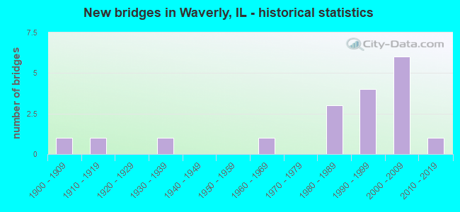
- New bridges - historical statistics
- 11900-1909
- 11910-1919
- 11930-1939
- 11960-1969
- 31980-1989
- 41990-1999
- 62000-2009
- 12010-2019


- Bridge Condition - Deck
- 27.3%Very good
- 54.5%Good
- 18.2%Satisfactory

- Bridge Condition - Superstructure
- 27.3%Very good
- 54.5%Good
- 9.1%Satisfactory
- 9.1%Fair

- Bridge Condition - Substructure
- 45.5%Very good
- 45.5%Good
- 9.1%Fair

- Bridge Condition - Channel
- 25.0%Very good
- 43.8%Good
- 31.3%Satisfactory

- Bridge Condition - Culverts
- 40.0%Very good
- 60.0%Good
Find on map >> Show street view
Structure Number: 690023, Location: 2.13M S IL 104 (Lat: 39.560636, Lng: -89.964025), Route carried "on" structure: State highway 111, Year Built: 1931, Year Reconstructed: 1974, Status: Open, Structure Length: 1.66m (5.45ft), Average Daily Traffic: 1,850 (year 2021), Truck Traffic: 17%, Average Future Daily Traffic: 1,912 (year 2032), Features Intersected: APPLE CREEK
Minimum Vertical Clearance: 30+ m (98+ ft), Kilometerpoint: 128.470, Lanes on structure: 2, Base Highway Network: Yes, Owner: State Highway Agency, Approaching Roadway Width: 12.2m (40.0ft), Skew: 1 degrees, Material/Design: Concrete, Design/Construction: Tee Beam, Number Of Spans In Main Unit: 1, Length of Maximum Span: 16.2m (53.1ft), Curb-To-Curb Width: 10.1m (33.1ft), Out-to-Out Width: 10.2m (33.5ft)
Condition: Deck: Satisfactory, Superstructure: Fair, Substructure: Good, Channel: Satisfactory, Operating Rating: 43.4 metric tons, Method Used To Determine Operating Rating: Load Factor (LF) rating reported by rating factor (RF) method using MS18 loading, Inventory Rating: 25.9 metric tons, Method Used To Determine Inventory Rating: Load Factor (LF) rating reported by rating factor (RF) method using MS18 loading, Structural Evaluation: Somewhat better than minimum adequacy, Deck Geometry: Somewhat better than minimum adequacy, Waterway Adequacy: Equal to present minimum criteria, Approach Roadway Alignment: Equal to present desirable criteria, Designated Inspection Frequency: Every 24 months, Inspection Date: January 2022, Deck Structure Type: Concrete Cast-file-Place, Wearing Surface/Protective System: Wearing Surface: Bituminous, Membrane: Built-up
Find on map >> Show street view
Structure Number: 69321, Location: 3MI SW WAVERLY (Lat: 39.550728, Lng: -89.999683), Route carried "on" structure: County highway , Year Built: 1988, Status: Open, Structure Length: 4.63m (15.19ft), Average Daily Traffic: 250 (year 2019), Truck Traffic: 4%, Average Future Daily Traffic: 319 (year 2032), Design Load: HS 20, Features Intersected: APPLE CREEK, Facility Carried by Structure: CH 18/FAS 617
Minimum Vertical Clearance: 30+ m (98+ ft), Kilometerpoint: 32.637, Lanes on structure: 2, Owner: County Highway Agency, Approaching Roadway Width: 7.3m (24.0ft), Skew: 3 degrees, Material/Design: Prestressed concrete, Design/Construction: Box Beam or Girders - Multiple, Number Of Spans In Main Unit: 3, Length of Maximum Span: 14.8m (48.6ft), Curb-To-Curb Width: 8.5m (27.9ft), Out-to-Out Width: 8.5m (27.9ft)
Condition: Deck: Good, Superstructure: Good, Substructure: Good, Channel: Satisfactory, Operating Rating: 59.9 metric tons, Method Used To Determine Operating Rating: Load Factor (LF) rating reported by rating factor (RF) method using MS18 loading, Inventory Rating: 36.0 metric tons, Method Used To Determine Inventory Rating: Load Factor (LF) rating reported by rating factor (RF) method using MS18 loading, Structural Evaluation: Better than present minimum criteria, Deck Geometry: Equal to present minimum criteria, Waterway Adequacy: Equal to present desirable criteria, Approach Roadway Alignment: Equal to present desirable criteria, Designated Inspection Frequency: Every 48 months, Inspection Date: December 2019, Deck Structure Type: Concrete Precast Panels, Wearing Surface/Protective System: Wearing Surface: Gravel, Membrane: Built-up
Find on map >> Show street view
Structure Number: 693226, Location: 2.0 MI SW WAVERLY (Lat: 39.550736, Lng: -89.992639), Route carried "on" structure: County highway , Year Built: 1995, Status: Open, Structure Length: 1.88m (6.17ft), Average Daily Traffic: 300 (year 2019), Truck Traffic: 42%, Average Future Daily Traffic: 372 (year 2032), Design Load: HS 20, Features Intersected: BRANCH APPLE CREEK, Facility Carried by Structure: CH 18
Minimum Vertical Clearance: 30+ m (98+ ft), Kilometerpoint: 33.200, Lanes on structure: 2, Owner: County Highway Agency, Approaching Roadway Width: 6.7m (22.0ft), Skew: 2 degrees, Material/Design: Prestressed concrete, Design/Construction: Box Beam or Girders - Multiple, Number Of Spans In Main Unit: 1, Length of Maximum Span: 17.9m (58.7ft), Curb-To-Curb Width: 8.5m (27.9ft), Out-to-Out Width: 8.5m (27.9ft)
Condition: Deck: Good, Superstructure: Good, Substructure: Very good, Channel: Very good, Operating Rating: 62.2 metric tons, Method Used To Determine Operating Rating: Load Factor (LF) rating reported by rating factor (RF) method using MS18 loading, Inventory Rating: 37.3 metric tons, Method Used To Determine Inventory Rating: Load Factor (LF) rating reported by rating factor (RF) method using MS18 loading, Structural Evaluation: Better than present minimum criteria, Deck Geometry: Equal to present minimum criteria, Waterway Adequacy: Equal to present desirable criteria, Approach Roadway Alignment: Equal to present desirable criteria, Designated Inspection Frequency: Every 48 months, Inspection Date: December 2019, Deck Structure Type: Concrete Precast Panels, Wearing Surface/Protective System: Wearing Surface: Gravel, Membrane: Built-up
Find on map >> Show street view
Structure Number: 693234, Location: 1.5MI S WAVERLY (Lat: 39.564739, Lng: -89.953314), Route carried "on" structure: County highway , Year Built: 1996, Status: Open, Structure Length: 2.32m (7.61ft), Average Daily Traffic: 75 (year 2019), Truck Traffic: 13%, Average Future Daily Traffic: 133 (year 2032), Design Load: HS 20, Features Intersected: APPLE CREEK, Facility Carried by Structure: TR 406
Minimum Vertical Clearance: 30+ m (98+ ft), Kilometerpoint: 2.350, Lanes on structure: 2, Owner: Town or Township Highway Agency, Approaching Roadway Width: 6.1m (20.0ft), Material/Design: Prestressed concrete, Design/Construction: Box Beam or Girders - Multiple, Number Of Spans In Main Unit: 1, Length of Maximum Span: 22.4m (73.5ft), Curb-To-Curb Width: 7.3m (24.0ft), Out-to-Out Width: 7.3m (24.0ft)
Condition: Deck: Very good, Superstructure: Very good, Substructure: Very good, Channel: Very good, Operating Rating: 44.1 metric tons, Method Used To Determine Operating Rating: Assigned rating based on Load Factor Design (LFD) reported by rating factor (RF) using MS18 loading, Inventory Rating: 32.4 metric tons, Method Used To Determine Inventory Rating: Assigned rating based on Load Factor Design (LFD) reported by rating factor (RF) using MS18 loading, Structural Evaluation: Equal to present desirable criteria, Deck Geometry: Equal to present minimum criteria, Waterway Adequacy: Equal to present desirable criteria, Approach Roadway Alignment: Equal to present desirable criteria, Designated Inspection Frequency: Every 48 months, Inspection Date: November 2019, Deck Structure Type: Concrete Precast Panels, Wearing Surface/Protective System: Wearing Surface: Bituminous, Membrane: Built-up
Find on map >> Show street view
Structure Number: 69324, Location: 2.0 MI SW WAVERLY (Lat: 39.561639, Lng: -89.987911), Route carried "on" structure: County highway , Year Built: 1999, Status: Open, Structure Length: 1.57m (5.15ft), Average Daily Traffic: 50 (year 2019), Truck Traffic: 6%, Average Future Daily Traffic: 27 (year 2032), Design Load: HS 20, Features Intersected: TRIB TO APPLE CREEK, Facility Carried by Structure: TR 347
Minimum Vertical Clearance: 30+ m (98+ ft), Kilometerpoint: 1.175, Lanes on structure: 2, Owner: Town or Township Highway Agency, Approaching Roadway Width: 7.3m (24.0ft), Skew: 2 degrees, Material/Design: Prestressed concrete, Design/Construction: Box Beam or Girders - Multiple, Number Of Spans In Main Unit: 1, Length of Maximum Span: 14.9m (48.9ft), Curb-To-Curb Width: 7.3m (24.0ft), Out-to-Out Width: 7.3m (24.0ft)
Condition: Deck: Good, Superstructure: Good, Substructure: Good, Channel: Good, Operating Rating: 44.1 metric tons, Method Used To Determine Operating Rating: Assigned rating based on Load Factor Design (LFD) reported by rating factor (RF) using MS18 loading, Inventory Rating: 32.4 metric tons, Method Used To Determine Inventory Rating: Assigned rating based on Load Factor Design (LFD) reported by rating factor (RF) using MS18 loading, Structural Evaluation: Better than present minimum criteria, Deck Geometry: Equal to present minimum criteria, Waterway Adequacy: Equal to present desirable criteria, Approach Roadway Alignment: Equal to present desirable criteria, Designated Inspection Frequency: Every 48 months, Inspection Date: November 2021, Deck Structure Type: Concrete Precast Panels, Wearing Surface/Protective System: Wearing Surface: Bituminous
Find on map >> Show street view
Structure Number: 693253, Location: 2.5 M S WAVERLY (Lat: 39.550783, Lng: -89.979303), Route carried "on" structure: County highway , Year Built: 2003, Status: Open, Structure Length: 1.78m (5.84ft), Average Daily Traffic: 300 (year 2019), Truck Traffic: 42%, Average Future Daily Traffic: 372 (year 2032), Design Load: HS 20, Features Intersected: APPLE CR TRIB, Facility Carried by Structure: CH 18
Minimum Vertical Clearance: 30+ m (98+ ft), Kilometerpoint: 34.375, Lanes on structure: 2, Owner: County Highway Agency, Approaching Roadway Width: 6.7m (22.0ft), Material/Design: Prestressed concrete, Design/Construction: Box Beam or Girders - Multiple, Number Of Spans In Main Unit: 1, Length of Maximum Span: 16.9m (55.4ft), Curb-To-Curb Width: 8.6m (28.2ft), Out-to-Out Width: 8.6m (28.2ft)
Condition: Deck: Very good, Superstructure: Very good, Substructure: Very good, Channel: Very good, Operating Rating: 68.0 metric tons, Method Used To Determine Operating Rating: Load Factor (LF) rating reported by rating factor (RF) method using MS18 loading, Inventory Rating: 40.8 metric tons, Method Used To Determine Inventory Rating: Load Factor (LF) rating reported by rating factor (RF) method using MS18 loading, Structural Evaluation: Equal to present desirable criteria, Deck Geometry: Equal to present minimum criteria, Waterway Adequacy: Equal to present desirable criteria, Approach Roadway Alignment: Equal to present desirable criteria, Designated Inspection Frequency: Every 48 months, Inspection Date: December 2019, Deck Structure Type: Concrete Precast Panels, Wearing Surface/Protective System: Wearing Surface: Gravel, Membrane: Built-up
Find on map >> Show street view
Structure Number: 695019, Location: 1.7 MI. S. OF WAVERL (Lat: 39.561714, Lng: -89.973500), Route carried "on" structure: County highway , Year Built: 1986, Status: Open, Structure Length: 0.82m (2.69ft), Average Daily Traffic: 50 (year 2019), Truck Traffic: 6%, Average Future Daily Traffic: 27 (year 2032), Design Load: HS 20, Features Intersected: BRANCH OF APPLE CK, Facility Carried by Structure: TR 347
Minimum Vertical Clearance: 30+ m (98+ ft), Kilometerpoint: 2.414, Lanes on structure: 2, Owner: Town or Township Highway Agency, Approaching Roadway Width: 3.7m (12.1ft), Material/Design: Concrete continuous, Design/Construction: Culvert, Number Of Spans In Main Unit: 3, Length of Maximum Span: 2.4m (7.9ft), Curb-To-Curb Width: 7.3m (24.0ft), Out-to-Out Width: 7.3m (24.0ft)
Condition: Channel: Satisfactory, Culverts: Very good, Operating Rating: 44.4 metric tons, Method Used To Determine Operating Rating: Assigned rating based on Load Factor Design (LFD) reported by rating factor (RF) using MS18 loading, Inventory Rating: 32.4 metric tons, Method Used To Determine Inventory Rating: Assigned rating based on Load Factor Design (LFD) reported by rating factor (RF) using MS18 loading, Structural Evaluation: Equal to present desirable criteria, Deck Geometry: Equal to present minimum criteria, Waterway Adequacy: Equal to present desirable criteria, Approach Roadway Alignment: Equal to present desirable criteria, Designated Inspection Frequency: Every 48 months, Inspection Date: December 2019
Find on map >> Show street view
Structure Number: 843179, Location: 6.0 SW OF LOAMI (Lat: 39.602244, Lng: -89.891417), Route carried "on" structure: County highway , Year Built: 1962, Status: Open, Structure Length: 3.65m (11.98ft), Average Daily Traffic: 75 (year 2017), Average Future Daily Traffic: 161 (year 2032), Design Load: HS 15, Features Intersected: S FORK LICK CREEK, Facility Carried by Structure: TR 403 13.5S
Minimum Vertical Clearance: 30+ m (98+ ft), Kilometerpoint: 4.232, Lanes on structure: 2, Owner: Town or Township Highway Agency, Approaching Roadway Width: 4.9m (16.1ft), Skew: 3 degrees, Material/Design: Concrete continuous, Design/Construction: Slab, Number Of Spans In Main Unit: 3, Length of Maximum Span: 13.7m (44.9ft), Curb-To-Curb Width: 7.3m (24.0ft), Out-to-Out Width: 8.0m (26.2ft)
Condition: Deck: Satisfactory, Superstructure: Satisfactory, Substructure: Fair, Channel: Satisfactory, Operating Rating: 38.2 metric tons, Method Used To Determine Operating Rating: Load Factor (LF) rating reported by rating factor (RF) method using MS18 loading, Inventory Rating: 23.0 metric tons, Method Used To Determine Inventory Rating: Load Factor (LF) rating reported by rating factor (RF) method using MS18 loading, Structural Evaluation: Somewhat better than minimum adequacy, Deck Geometry: Equal to present minimum criteria, Waterway Adequacy: Better than present minimum criteria, Approach Roadway Alignment: Better than present minimum criteria, Designated Inspection Frequency: Every 24 months, Inspection Date: March 2021, Deck Structure Type: Concrete Cast-file-Place
Find on map >> Show street view
Structure Number: 84353, Location: 2.5 NE OF CURRAN (Lat: 39.565861, Lng: -89.906089), Route carried "on" structure: County highway , Year Built: 1980, Status: Open, Structure Length: 1.21m (3.97ft), Average Daily Traffic: 25 (year 2017), Average Future Daily Traffic: 322 (year 2032), Design Load: HS 20, Features Intersected: LITTLE SPRING CREEK, Facility Carried by Structure: CURRAN TR249
Minimum Vertical Clearance: 30+ m (98+ ft), Kilometerpoint: 1.545, Lanes on structure: 2, Owner: Town or Township Highway Agency, Approaching Roadway Width: 5.5m (18.0ft), Skew: 2 degrees, Material/Design: Concrete continuous, Design/Construction: Culvert, Number Of Spans In Main Unit: 3, Length of Maximum Span: 4.1m (13.5ft)
Condition: Channel: Good, Culverts: Good, Operating Rating: 44.4 metric tons, Method Used To Determine Operating Rating: Assigned rating based on Load Factor Design (LFD) reported by rating factor (RF) using MS18 loading, Inventory Rating: 32.4 metric tons, Method Used To Determine Inventory Rating: Assigned rating based on Load Factor Design (LFD) reported by rating factor (RF) using MS18 loading, Structural Evaluation: Better than present minimum criteria, Waterway Adequacy: Better than present minimum criteria, Approach Roadway Alignment: Better than present minimum criteria, Designated Inspection Frequency: Every 48 months, Inspection Date: March 2018
Find on map >> Show street view
Structure Number: 843568, Location: 2.3 mi NE Waverly (Lat: 39.616644, Lng: -89.920514), Route carried "on" structure: County highway , Year Built: 2012, Status: Open, Structure Length: 2.97m (9.74ft), Average Daily Traffic: 50 (year 2017), Truck Traffic: 40%, Average Future Daily Traffic: 80 (year 2032), Design Load: HS 20, Features Intersected: LICK CREEK, Facility Carried by Structure: TR 381A
Minimum Vertical Clearance: 30+ m (98+ ft), Kilometerpoint: 0.547, Lanes on structure: 2, Owner: Town or Township Highway Agency, Approaching Roadway Width: 6.1m (20.0ft), Material/Design: Prestressed concrete, Design/Construction: Box Beam or Girders - Multiple, Number Of Spans In Main Unit: 3, Length of Maximum Span: 10.3m (33.8ft), Curb-To-Curb Width: 8.5m (27.9ft), Out-to-Out Width: 8.5m (27.9ft)
Condition: Deck: Very good, Superstructure: Very good, Substructure: Very good, Channel: Satisfactory, Operating Rating: 42.1 metric tons, Method Used To Determine Operating Rating: Assigned ratings based on Load and Resistance Factor Design (LRFD) reported by rating factor (RF) using HL93 loadings, Inventory Rating: 32.4 metric tons, Method Used To Determine Inventory Rating: Assigned ratings based on Load and Resistance Factor Design (LRFD) reported by rating factor (RF) using HL93 loadings, Structural Evaluation: Equal to present desirable criteria, Deck Geometry: Better than present minimum criteria, Waterway Adequacy: Better than present minimum criteria, Approach Roadway Alignment: Equal to present desirable criteria, Designated Inspection Frequency: Every 48 months, Inspection Date: March 2019, Deck Structure Type: Concrete Precast Panels, Wearing Surface/Protective System: Wearing Surface: Bituminous
Find on map >> Show street view
Structure Number: 843578, Location: 6.0 SW OF LOAMI (Lat: 39.602053, Lng: -89.912764), Route carried "on" structure: County highway , Year Built: 1997, Status: Open, Structure Length: 3.04m (9.97ft), Average Daily Traffic: 75 (year 2017), Average Future Daily Traffic: 161 (year 2032), Design Load: HS 20, Features Intersected: S FORK LICK CREEK, Facility Carried by Structure: TR-403
Minimum Vertical Clearance: 30+ m (98+ ft), Kilometerpoint: 2.382, Lanes on structure: 2, Owner: Town or Township Highway Agency, Approaching Roadway Width: 5.9m (19.4ft), Skew: 1 degrees, Material/Design: Prestressed concrete, Design/Construction: Box Beam or Girders - Multiple, Number Of Spans In Main Unit: 3, Length of Maximum Span: 29.6m (97.1ft), Curb-To-Curb Width: 8.2m (26.9ft), Out-to-Out Width: 8.2m (26.9ft)
Condition: Deck: Good, Superstructure: Good, Substructure: Good, Channel: Good, Operating Rating: 44.1 metric tons, Method Used To Determine Operating Rating: Assigned rating based on Load Factor Design (LFD) reported by rating factor (RF) using MS18 loading, Inventory Rating: 32.4 metric tons, Method Used To Determine Inventory Rating: Assigned rating based on Load Factor Design (LFD) reported by rating factor (RF) using MS18 loading, Structural Evaluation: Better than present minimum criteria, Deck Geometry: Equal to present minimum criteria, Waterway Adequacy: Equal to present desirable criteria, Approach Roadway Alignment: Equal to present desirable criteria, Designated Inspection Frequency: Every 48 months, Inspection Date: March 2018, Deck Structure Type: Concrete Precast Panels, Wearing Surface/Protective System: Wearing Surface: Bituminous
Find on map >> Show street view
Structure Number: 843599, Location: 5.0 SW LOAMI (Lat: 39.620425, Lng: -89.945772), Route carried "on" structure: County highway , Year Built: 2005, Status: Open, Structure Length: 1.85m (6.07ft), Average Daily Traffic: 50 (year 2018), Average Future Daily Traffic: 241 (year 2032), Design Load: HS 20, Features Intersected: SOUTH FORK CREEK, Facility Carried by Structure: TR 16
Minimum Vertical Clearance: 30+ m (98+ ft), Kilometerpoint: 3.605, Lanes on structure: 2, Owner: Town or Township Highway Agency, Approaching Roadway Width: 6.1m (20.0ft), Skew: 2 degrees, Material/Design: Prestressed concrete, Design/Construction: Box Beam or Girders - Multiple, Number Of Spans In Main Unit: 1, Length of Maximum Span: 17.7m (58.1ft), Curb-To-Curb Width: 8.4m (27.6ft), Out-to-Out Width: 8.4m (27.6ft)
Condition: Deck: Good, Superstructure: Good, Substructure: Very good, Channel: Good, Operating Rating: 44.1 metric tons, Method Used To Determine Operating Rating: Assigned rating based on Load Factor Design (LFD) reported by rating factor (RF) using MS18 loading, Inventory Rating: 32.4 metric tons, Method Used To Determine Inventory Rating: Assigned rating based on Load Factor Design (LFD) reported by rating factor (RF) using MS18 loading, Structural Evaluation: Better than present minimum criteria, Deck Geometry: Equal to present minimum criteria, Waterway Adequacy: Equal to present desirable criteria, Approach Roadway Alignment: Equal to present desirable criteria, Designated Inspection Frequency: Every 48 months, Inspection Date: March 2020, Deck Structure Type: Concrete Precast Panels, Wearing Surface/Protective System: Wearing Surface: Bituminous
Find on map >> Show street view
Structure Number: 843643, Location: 7 S NEW BERLIN (Lat: 39.623153, Lng: -89.926967), Route carried "on" structure: County highway , Year Built: 2006, Status: Open, Structure Length: 2.81m (9.22ft), Average Daily Traffic: 1,650 (year 2017), Truck Traffic: 12%, Average Future Daily Traffic: 1,554 (year 2032), Design Load: HS 20, Features Intersected: LICK CREEK, Facility Carried by Structure: CH-10
Minimum Vertical Clearance: 30+ m (98+ ft), Kilometerpoint: 41.005, Lanes on structure: 2, Owner: County Highway Agency, Approaching Roadway Width: 11.0m (36.1ft), Material/Design: Prestressed concrete, Design/Construction: Box Beam or Girders - Multiple, Number Of Spans In Main Unit: 3, Length of Maximum Span: 27.1m (88.9ft), Curb-To-Curb Width: 11.0m (36.1ft), Out-to-Out Width: 11.0m (36.1ft)
Condition: Deck: Good, Superstructure: Good, Substructure: Good, Channel: Very good, Operating Rating: 44.1 metric tons, Method Used To Determine Operating Rating: Assigned rating based on Load Factor Design (LFD) reported by rating factor (RF) using MS18 loading, Inventory Rating: 32.4 metric tons, Method Used To Determine Inventory Rating: Assigned rating based on Load Factor Design (LFD) reported by rating factor (RF) using MS18 loading, Structural Evaluation: Better than present minimum criteria, Deck Geometry: Equal to present minimum criteria, Waterway Adequacy: Equal to present desirable criteria, Approach Roadway Alignment: Equal to present desirable criteria, Designated Inspection Frequency: Every 48 months, Inspection Date: March 2020, Deck Structure Type: Concrete Precast Panels, Wearing Surface/Protective System: Wearing Surface: Bituminous, Membrane: Built-up
Find on map >> Show street view
Structure Number: 845535, Location: 3.0 MI NW LOWDER (Lat: 39.589614, Lng: -89.888708), Route carried "on" structure: County highway , Year Built: 2000, Status: Open, Structure Length: 0.92m (3.02ft), Average Daily Traffic: 50 (year 2017), Average Future Daily Traffic: 63 (year 2032), Design Load: HS 20, Features Intersected: DRAINAGE DITCH, Facility Carried by Structure: TR 52
Minimum Vertical Clearance: 30+ m (98+ ft), Kilometerpoint: 1.400, Lanes on structure: 2, Owner: Town or Township Highway Agency, Approaching Roadway Width: 6.1m (20.0ft), Skew: 3 degrees, Material/Design: Concrete continuous, Design/Construction: Culvert, Number Of Spans In Main Unit: 2, Length of Maximum Span: 4.2m (13.8ft), Curb-To-Curb Width: 8.5m (27.9ft), Out-to-Out Width: 8.5m (27.9ft)
Condition: Channel: Good, Culverts: Good, Operating Rating: 44.1 metric tons, Method Used To Determine Operating Rating: Assigned rating based on Load Factor Design (LFD) reported by rating factor (RF) using MS18 loading, Inventory Rating: 32.4 metric tons, Method Used To Determine Inventory Rating: Assigned rating based on Load Factor Design (LFD) reported by rating factor (RF) using MS18 loading, Structural Evaluation: Better than present minimum criteria, Deck Geometry: Better than present minimum criteria, Waterway Adequacy: Better than present minimum criteria, Approach Roadway Alignment: Equal to present desirable criteria, Designated Inspection Frequency: Every 48 months, Inspection Date: March 2019
Find on map >> Show street view
Structure Number: 845536, Location: 3.5 MI NW LOWDER (Lat: 39.595997, Lng: -89.888764), Route carried "on" structure: County highway , Year Built: 2001, Status: Open, Structure Length: 0.66m (2.17ft), Average Daily Traffic: 50 (year 2017), Average Future Daily Traffic: 63 (year 2032), Features Intersected: TRIB S FORK LICK CK, Facility Carried by Structure: TR-52
Minimum Vertical Clearance: 30+ m (98+ ft), Kilometerpoint: 0.692, Lanes on structure: 2, Owner: Town or Township Highway Agency, Approaching Roadway Width: 6.1m (20.0ft), Material/Design: Concrete continuous, Design/Construction: Culvert, Number Of Spans In Main Unit: 2, Length of Maximum Span: 3.2m (10.5ft), Curb-To-Curb Width: 12.8m (42.0ft), Out-to-Out Width: 12.8m (42.0ft)
Condition: Channel: Good, Culverts: Good, Operating Rating: 83.3 metric tons, Method Used To Determine Operating Rating: Load Factor (LF) rating reported by rating factor (RF) method using MS18 loading, Inventory Rating: 49.9 metric tons, Method Used To Determine Inventory Rating: Load Factor (LF) rating reported by rating factor (RF) method using MS18 loading, Structural Evaluation: Better than present minimum criteria, Deck Geometry: Superior to present desirable criteria, Waterway Adequacy: Equal to present desirable criteria, Approach Roadway Alignment: Equal to present desirable criteria, Designated Inspection Frequency: Every 48 months, Inspection Date: March 2019
Find on map >> Show street view
Structure Number: 845537, Location: 2.5 M NW LOWDER (Lat: 39.573286, Lng: -89.887031), Route carried "on" structure: County highway , Year Built: 2007, Status: Open, Structure Length: 0.66m (2.17ft), Average Daily Traffic: 50 (year 2017), Average Future Daily Traffic: 31 (year 2032), Design Load: HS 20, Features Intersected: DITCH, Facility Carried by Structure: TR 427A
Minimum Vertical Clearance: 30+ m (98+ ft), Kilometerpoint: 0.418, Lanes on structure: 2, Owner: Town or Township Highway Agency, Approaching Roadway Width: 5.5m (18.0ft), Material/Design: Concrete continuous, Design/Construction: Culvert, Number Of Spans In Main Unit: 2, Length of Maximum Span: 3.4m (11.2ft)
Condition: Channel: Good, Culverts: Very good, Operating Rating: 44.1 metric tons, Method Used To Determine Operating Rating: Assigned rating based on Load Factor Design (LFD) reported by rating factor (RF) using MS18 loading, Inventory Rating: 32.4 metric tons, Method Used To Determine Inventory Rating: Assigned rating based on Load Factor Design (LFD) reported by rating factor (RF) using MS18 loading, Structural Evaluation: Equal to present desirable criteria, Waterway Adequacy: Equal to present desirable criteria, Approach Roadway Alignment: Equal to present desirable criteria, Designated Inspection Frequency: Every 48 months, Inspection Date: March 2021
Find on map >> Show street view
Structure Number: 849908, Location: 3M E WAVERLY(E CH10) (Lat: 39.587419, Lng: -89.921400), Route carried "under" structure: State highway 104, Year Built: 1913, Structure Length: 0. m, Average Daily Traffic: 1,850 (year 2021), Truck Traffic: 17%, Features Intersected: IL 104 (FAP 753), Facility Carried by Structure: BURLINGTON NORTH.
Minimum Vertical Clearance: 5.31m (17.42ft), Kilometerpoint: 149.858, Lanes under structure: 2, Material/Design: Steel, Design/Construction: Girder and Floorbeam System, Length of Maximum Span: 9.8m (32.2ft)
Find on map >> Show street view
Structure Number: 849913, Location: P M S NEW BERLIN (Lat: 39.589906, Lng: -89.926586), Route carried "under" structure: County highway , Year Built: 1900, Structure Length: 0. m, Average Daily Traffic: 1,650 (year 2017), Truck Traffic: 16%, Features Intersected: FAS 621, Facility Carried by Structure: B&N RR
Minimum Vertical Clearance: 6.07m (19.91ft), Kilometerpoint: 44.722, Lanes under structure: 2, Material/Design: Steel, Design/Construction: Stringer/Multi-beam, Length of Maximum Span: 14.0m (45.9ft)