Bridge Statistics for Wausau, Florida (FL)
Condition, Traffic, Stress, Structural Evaluation, Project Costs
- National Bridge Inventory (NBI) Statistics
- 10Number of bridges
- 125ft / 37.9mTotal length
- 24,410Total average daily traffic
- 2,181Total average daily truck traffic
- 39,412Total future (year 2041) average daily traffic
- National Bridge Inventory (NBI) Registered Bridges for Wausau
- No street view available for this location
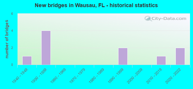
- New bridges - historical statistics
- 11940-1949
- 41950-1959
- 21990-1999
- 12010-2019
- 22020-2022


- Bridge Condition - Deck
- 20.0%Very good
- 40.0%Good
- 20.0%Satisfactory
- 20.0%Poor

- Bridge Condition - Superstructure
- 40.0%Very good
- 20.0%Good
- 20.0%Poor
- 20.0%Serious

- Bridge Condition - Substructure
- 20.0%Very good
- 40.0%Good
- 40.0%Fair

- Bridge Condition - Channel
- 20.0%Very good
- 40.0%Good
- 20.0%Satisfactory
- 20.0%Fair

- Bridge Condition - Culverts
- 40.0%Good
- 40.0%Satisfactory
- 20.0%Serious
Find on map >> Show street view
Structure Number: 610011, Location: 1.1 Mile North of CR278 (Lat: 30.647500, Lng: -85.583222), Route carried "on" structure: State highway 77, Year Built: 1957, Status: Open, Structure Length: 0.76m (2.49ft), Average Daily Traffic: 5,300 (year 2020), Truck Traffic: 12%, Average Future Daily Traffic: 9,196 (year 2042), Design Load: H 20, Features Intersected: Stream
Minimum Vertical Clearance: 30+ m (98+ ft), Kilometerpoint: 26.580, Lanes on structure: 2, Base Highway Network: Yes, Owner: State Highway Agency, Approaching Roadway Width: 10.4m (34.1ft), Material/Design: Concrete, Design/Construction: Culvert, Number Of Spans In Main Unit: 3, Length of Maximum Span: 2.4m (7.9ft)
Condition: Channel: Good, Culverts: Satisfactory, Operating Rating: 80.7 metric tons, Method Used To Determine Operating Rating: Load Factor (LF), Inventory Rating: 49.0 metric tons, Method Used To Determine Inventory Rating: Load Factor (LF), Structural Evaluation: Equal to present minimum criteria, Waterway Adequacy: Equal to present desirable criteria, Approach Roadway Alignment: Equal to present desirable criteria, Designated Inspection Frequency: Every 24 months, Inspection Date: March 2021
Find on map >> Show street view
Structure Number: 610014, Location: 0.2 Mi West of SR 77 (Lat: 30.632019, Lng: -85.585247), Route carried "on" structure: County highway 278, Year Built: 1958, Status: Open, Structure Length: 0.95m (3.12ft), Average Daily Traffic: 900 (year 2020), Truck Traffic: 7%, Average Future Daily Traffic: 1,562 (year 2042), Design Load: HS 20, Features Intersected: Reedy Creek
Minimum Vertical Clearance: 30+ m (98+ ft), Kilometerpoint: 11.848, Lanes on structure: 2, Owner: County Highway Agency, Approaching Roadway Width: 7.0m (23.0ft), Material/Design: Concrete, Design/Construction: Culvert, Number Of Spans In Main Unit: 3, Length of Maximum Span: 3.2m (10.5ft)
Condition: Channel: Fair, Culverts: Good, Operating Rating: 46.3 metric tons, Method Used To Determine Operating Rating: Load Factor (LF), Inventory Rating: 27.2 metric tons, Method Used To Determine Inventory Rating: Load Factor (LF), Structural Evaluation: Equal to present minimum criteria, Waterway Adequacy: Better than present minimum criteria, Approach Roadway Alignment: Better than present minimum criteria, Designated Inspection Frequency: Every 24 months, Inspection Date: August 2020
Find on map >> Show street view
Structure Number: 610021, Location: 0.25 Mi West of SR 77 (Lat: 30.633167, Lng: -85.592333), Route carried "on" structure: County highway 278, Year Built: 1940, Status: Open, Structure Length: 0.87m (2.85ft), Average Daily Traffic: 1,000 (year 2020), Truck Traffic: 8%, Average Future Daily Traffic: 1,735 (year 2042), Design Load: HL 93, Features Intersected: Unnamed Branch
Minimum Vertical Clearance: 30+ m (98+ ft), Kilometerpoint: 11.119, Lanes on structure: 2, Owner: County Highway Agency, Approaching Roadway Width: 6.7m (22.0ft), Material/Design: Steel, Design/Construction: Culvert, Number Of Spans In Main Unit: 2, Length of Maximum Span: 4.3m (14.1ft)
Condition: Channel: Satisfactory, Culverts: Serious, Structural Evaluation: High priority of corrective action, Waterway Adequacy: Better than present minimum criteria, Approach Roadway Alignment: Equal to present desirable criteria, Designated Inspection Frequency: Every 24 months, Other Special Inspection Frequency: Every 6 months, Inspection Date: August 2020, Other Special Inspection Date: Febuary 2022
Find on map >> Show street view
Structure Number: 610043, Location: 0.14 Mi East of SR 77 (Lat: 30.631667, Lng: -85.586311), Route carried "on" structure: County highway 278, Year Built: 1958, Status: Open, Structure Length: 0.95m (3.12ft), Average Daily Traffic: 1,000 (year 2020), Truck Traffic: 8%, Average Future Daily Traffic: 1,735 (year 2042), Design Load: HS 20, Features Intersected: Reedy Creek
Minimum Vertical Clearance: 30+ m (98+ ft), Kilometerpoint: 11.745, Lanes on structure: 2, Owner: County Highway Agency, Approaching Roadway Width: 6.7m (22.0ft), Material/Design: Concrete, Design/Construction: Culvert, Number Of Spans In Main Unit: 3, Length of Maximum Span: 3.2m (10.5ft)
Condition: Channel: Fair, Culverts: Satisfactory, Operating Rating: 47.2 metric tons, Method Used To Determine Operating Rating: Load Factor (LF), Inventory Rating: 28.1 metric tons, Method Used To Determine Inventory Rating: Load Factor (LF), Structural Evaluation: Equal to present minimum criteria, Waterway Adequacy: Better than present minimum criteria, Approach Roadway Alignment: Better than present minimum criteria, Designated Inspection Frequency: Every 24 months, Other Special Inspection Frequency: Every 12 months, Inspection Date: August 2020, Other Special Inspection Date: August 2021
Find on map >> Show street view
Structure Number: 610044, Location: 0.05 Mi S of Roland Rd (Lat: 30.632864, Lng: -85.552406), Route carried "on" structure: County highway 278, Year Built: 1958, Status: Posted for load, Structure Length: 6.11m (20.05ft), Average Daily Traffic: 900 (year 2021), Truck Traffic: 8%, Average Future Daily Traffic: 1,562 (year 2042), Design Load: H 15, Features Intersected: Hard Labor Creek
Minimum Vertical Clearance: 30+ m (98+ ft), Kilometerpoint: 15.220, Lanes on structure: 2, Owner: County Highway Agency, Approaching Roadway Width: 6.7m (22.0ft), Material/Design: Concrete, Design/Construction: Slab, Number Of Spans In Main Unit: 10, Length of Maximum Span: 6.2m (20.3ft), Curb or Sidewalk Widths: Left: 0.2m (0.7ft), Right: 0.2m (0.7ft), Curb-To-Curb Width: 7.2m (23.6ft), Out-to-Out Width: 7.8m (25.6ft)
Condition: Deck: Poor, Superstructure: Poor, Substructure: Fair, Channel: Good, Operating Rating: 19.3 metric tons, Method Used To Determine Operating Rating: Load and Resistance Factor (LRFR), Inventory Rating: 14.9 metric tons, Method Used To Determine Inventory Rating: Load and Resistance Factor (LRFR), Structural Evaluation: Meets minimum limits, Deck Geometry: Meets minimum limits, Waterway Adequacy: Equal to present desirable criteria, Approach Roadway Alignment: Equal to present minimum criteria, Bridge Posting: Required (Relationship of Operating Rating to Maximum Legal Load: 30.0 - 39.9% below), Designated Inspection Frequency: Every 24 months, Underwater Inspection Frequency: Every 24 months, Other Special Inspection Frequency: Every 12 months, Inspection Date: June 2020, Underwater Inspection Date: June 2020, Other Special Inspection Date: June 2021, Deck Structure Type: Concrete Cast-file-Place
Find on map >> Show street view
Structure Number: 610082, Location: 2.0MI N. OF Wausau (Lat: 30.663419, Lng: -85.576953), Route carried "on" structure: State highway 77, Year Built: 1992, Status: Open, Structure Length: 8.53m (27.99ft), Average Daily Traffic: 5,300 (year 2020), Truck Traffic: 12%, Average Future Daily Traffic: 9,196 (year 2042), Design Load: HS 20+Mod, Features Intersected: Hard Labor Creek
Minimum Vertical Clearance: 30+ m (98+ ft), Kilometerpoint: 28.447, Lanes on structure: 2, Base Highway Network: Yes, Owner: State Highway Agency, Approaching Roadway Width: 10.4m (34.1ft), Material/Design: Prestressed concrete, Design/Construction: Slab, Number Of Spans In Main Unit: 10, Length of Maximum Span: 8.5m (27.9ft), Curb-To-Curb Width: 13.4m (44.0ft), Out-to-Out Width: 14.3m (46.9ft)
Condition: Deck: Good, Superstructure: Good, Substructure: Good, Channel: Very good, Operating Rating: 54.4 metric tons, Method Used To Determine Operating Rating: Load Factor (LF), Inventory Rating: 40.8 metric tons, Method Used To Determine Inventory Rating: Load Factor (LF), Structural Evaluation: Better than present minimum criteria, Deck Geometry: Superior to present desirable criteria, Waterway Adequacy: Equal to present desirable criteria, Approach Roadway Alignment: Equal to present desirable criteria, Designated Inspection Frequency: Every 24 months, Underwater Inspection Frequency: Every 24 months, Inspection Date: August 2020, Underwater Inspection Date: August 2020, Deck Structure Type: Concrete Precast Panels
Find on map >> Show street view
Structure Number: 610165, Location: 2.0 Miles N. of Wausau (Lat: 30.662967, Lng: -85.594028), Route carried "on" structure: State highway 77, Year Built: 2020, Status: Open, Structure Length: 11.95m (39.21ft), Average Daily Traffic: 8,900 (year 2021), Truck Traffic: 6%, Average Future Daily Traffic: 12,500 (year 2041), Design Load: HL 93, Features Intersected: Hard Labor Creek
Minimum Vertical Clearance: 30+ m (98+ ft), Kilometerpoint: 28.447, Lanes on structure: 2, Base Highway Network: Yes, Owner: State Highway Agency, Approaching Roadway Width: 10.4m (34.1ft), Material/Design: Prestressed concrete, Design/Construction: Stringer/Multi-beam, Number Of Spans In Main Unit: 7, Length of Maximum Span: 17.1m (56.1ft), Curb-To-Curb Width: 10.4m (34.1ft), Out-to-Out Width: 13.1m (43.0ft)
Condition: Deck: Very good, Superstructure: Very good, Substructure: Very good, Channel: Very good, Operating Rating: 57.2 metric tons, Method Used To Determine Operating Rating: Load and Resistance Factor (LRFR), Inventory Rating: 43.5 metric tons, Method Used To Determine Inventory Rating: Load and Resistance Factor (LRFR), Structural Evaluation: Equal to present desirable criteria, Deck Geometry: Somewhat better than minimum adequacy, Waterway Adequacy: Equal to present desirable criteria, Approach Roadway Alignment: Equal to present desirable criteria, Designated Inspection Frequency: Every 24 months, Inspection Date: June 2020, Deck Structure Type: Concrete Cast-file-Place, Wearing Surface/Protective System: Wearing Surface: Monolithic Concrete
Find on map >> Show street view
Structure Number: 614142, Location: 1.37 Mi S of CR 267A (Lat: 30.677169, Lng: -85.609264), Route carried "on" structure: County highway , Year Built: 1990, Year Reconstructed: 2018, Status: Posted for load, Structure Length: 2.59m (8.50ft), Average Daily Traffic: 60 (year 2021), Average Future Daily Traffic: 104 (year 2042), Features Intersected: Hard Labor Creek, Facility Carried by Structure: Hard Labor Road
Minimum Vertical Clearance: 30+ m (98+ ft), Kilometerpoint: 5.823, Lanes on structure: 1, Owner: County Highway Agency, Approaching Roadway Width: 4.9m (16.1ft), Material/Design: Wood or Timber, Design/Construction: Stringer/Multi-beam, Number Of Spans In Main Unit: 6, Length of Maximum Span: 4.5m (14.8ft), Curb-To-Curb Width: 4.9m (16.1ft), Out-to-Out Width: 4.9m (16.1ft)
Condition: Deck: Satisfactory, Superstructure: Serious, Substructure: Fair, Channel: Satisfactory, Operating Rating: 24.5 metric tons, Method Used To Determine Operating Rating: Allowable Stress (AS), Inventory Rating: 18.3 metric tons, Method Used To Determine Inventory Rating: Allowable Stress (AS), Structural Evaluation: High priority of corrective action, Deck Geometry: High priority of corrective action, Waterway Adequacy: Better than present minimum criteria, Approach Roadway Alignment: Equal to present desirable criteria, Bridge Posting: Required (Relationship of Operating Rating to Maximum Legal Load: 20.0 - 29.9% below), Designated Inspection Frequency: Every 24 months, Underwater Inspection Frequency: Every 24 months, Other Special Inspection Frequency: Every 6 months, Inspection Date: March 2020, Underwater Inspection Date: March 2020, Other Special Inspection Date: September 2021, Deck Structure Type: Wood or Timber
Find on map >> Show street view
Structure Number: 614159, Location: 0.52 Mi South of CR 276 (Lat: 30.691722, Lng: -85.584722), Route carried "on" structure: County highway , Year Built: 2013, Status: Open, Structure Length: 4.39m (14.40ft), Average Daily Traffic: 50 (year 2021), Average Future Daily Traffic: 87 (year 2042), Design Load: HL 93, Features Intersected: Flat Creek, Facility Carried by Structure: Duncan Cmty Road
Minimum Vertical Clearance: 30+ m (98+ ft), Kilometerpoint: 1.178, Lanes on structure: 2, Owner: County Highway Agency, Approaching Roadway Width: 6.1m (20.0ft), Material/Design: Concrete continuous, Design/Construction: Slab, Number Of Spans In Main Unit: 4, Length of Maximum Span: 11.0m (36.1ft), Curb-To-Curb Width: 7.3m (24.0ft), Out-to-Out Width: 8.3m (27.2ft)
Condition: Deck: Good, Superstructure: Very good, Substructure: Good, Channel: Good, Operating Rating: 57.5 metric tons, Method Used To Determine Operating Rating: Load and Resistance Factor (LRFR), Inventory Rating: 44.5 metric tons, Method Used To Determine Inventory Rating: Load and Resistance Factor (LRFR), Structural Evaluation: Better than present minimum criteria, Deck Geometry: Equal to present minimum criteria, Waterway Adequacy: Equal to present desirable criteria, Approach Roadway Alignment: Equal to present desirable criteria, Designated Inspection Frequency: Every 24 months, Inspection Date: December 2021, Deck Structure Type: Concrete Cast-file-Place
Find on map >> Show street view
Structure Number: 614169, Location: 0.3 Miles West of SR278 (Lat: 30.630778, Lng: -85.641278), Route carried "on" structure: County highway 278, Year Built: 2021, Status: Open, Structure Length: 0.75m (2.46ft), Average Daily Traffic: 1,000 (year 2020), Truck Traffic: 8%, Average Future Daily Traffic: 1,735 (year 2042), Design Load: HL 93, Features Intersected: Piney Branch
Minimum Vertical Clearance: 30+ m (98+ ft), Kilometerpoint: 6.293, Lanes on structure: 2, Owner: County Highway Agency, Approaching Roadway Width: 7.3m (24.0ft), Skew: 1 degrees, Material/Design: Concrete, Design/Construction: Culvert, Number Of Spans In Main Unit: 2, Length of Maximum Span: 3.7m (12.1ft)
Condition: Channel: Good, Culverts: Good, Operating Rating: 52.9 metric tons, Method Used To Determine Operating Rating: Load and Resistance Factor (LRFR), Inventory Rating: 40.8 metric tons, Method Used To Determine Inventory Rating: Load and Resistance Factor (LRFR), Structural Evaluation: Better than present minimum criteria, Waterway Adequacy: Better than present minimum criteria, Approach Roadway Alignment: Equal to present desirable criteria, Designated Inspection Frequency: Every 24 months, Inspection Date: April 2021