Bridge Statistics for Waukechon, Wisconsin (WI)
Condition, Traffic, Stress, Structural Evaluation, Project Costs
- National Bridge Inventory (NBI) Statistics
- 11Number of bridges
- 194ft / 59.0mTotal length
- 49,066Total average daily traffic
- 2,292Total average daily truck traffic
- National Bridge Inventory (NBI) Registered Bridges for Waukechon
- No street view available for this location
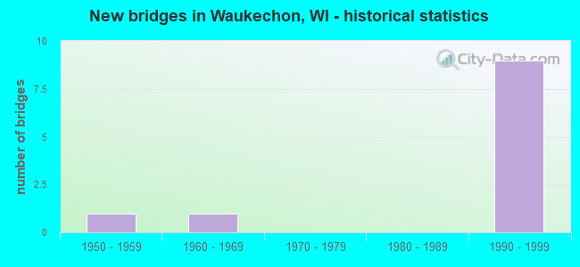
- New bridges - historical statistics
- 11950-1959
- 11960-1969
- 91990-1999


- Bridge Condition - Deck
- 75.0%Good
- 25.0%Fair

- Bridge Condition - Superstructure
- 25.0%Very good
- 50.0%Good
- 25.0%Fair

- Bridge Condition - Substructure
- 25.0%Very good
- 37.5%Good
- 12.5%Satisfactory
- 25.0%Fair
Find on map >> Show street view
Structure Number: B580011, Location: 0.3M W JCT CTH K (Lat: 44.696389, Lng: -88.578611), Route carried "on" structure: County highway , Year Built: 1952, Status: Open, Structure Length: 6.20m (20.34ft), Average Daily Traffic: 453 (year 2019), Average Future Daily Traffic: 498 (year 2040), Design Load: H 15, Features Intersected: WOLF RIVER, Facility Carried by Structure: CTH CCC
Minimum Vertical Clearance: 30+ m (98+ ft), Kilometerpoint: 0.000, Lanes on structure: 2, Owner: County Highway Agency, Approaching Roadway Width: 7.9m (25.9ft), Material/Design: Steel continuous, Design/Construction: Stringer/Multi-beam, Number Of Spans In Main Unit: 2, Length of Maximum Span: 30.5m (100.1ft), Curb-To-Curb Width: 7.3m (24.0ft), Out-to-Out Width: 8.1m (26.6ft)
Condition: Deck: Fair, Superstructure: Fair, Substructure: Fair, Channel: Very good, Operating Rating: 37.6 metric tons, Method Used To Determine Operating Rating: Load Factor (LF), Inventory Rating: 21.1 metric tons, Method Used To Determine Inventory Rating: Load Factor (LF), Structural Evaluation: Somewhat better than minimum adequacy, Deck Geometry: Meets minimum limits, Waterway Adequacy: Equal to present desirable criteria, Approach Roadway Alignment: Equal to present desirable criteria, Designated Inspection Frequency: Every 24 months, Underwater Inspection Frequency: Every 60 months, Inspection Date: August 2021, Underwater Inspection Date: July 2017, Deck Structure Type: Concrete Cast-file-Place, Wearing Surface/Protective System: Wearing Surface: Monolithic Concrete
Find on map >> Show street view
Structure Number: B580023, Location: 2.7M N JCT CTH T (Lat: 44.729089, Lng: -88.556361), Route carried "on" structure: County highway , Year Built: 1967, Status: Open, Structure Length: 1.21m (3.97ft), Average Daily Traffic: 1,133 (year 2019), Average Future Daily Traffic: 1,246 (year 2040), Design Load: H 20, Features Intersected: SCHOOL CREEK, Facility Carried by Structure: CTH K
Minimum Vertical Clearance: 30+ m (98+ ft), Kilometerpoint: 0.000, Lanes on structure: 2, Owner: County Highway Agency, Approaching Roadway Width: 8.5m (27.9ft), Material/Design: Prestressed concrete, Design/Construction: Slab, Number Of Spans In Main Unit: 1, Length of Maximum Span: 11.4m (37.4ft), Curb-To-Curb Width: 8.7m (28.5ft), Out-to-Out Width: 9.1m (29.9ft)
Condition: Deck: Fair, Superstructure: Fair, Substructure: Fair, Channel: Very good, Operating Rating: 39.2 metric tons, Method Used To Determine Operating Rating: Field evaluation and documented engineering judgment, Inventory Rating: 22.7 metric tons, Method Used To Determine Inventory Rating: Field evaluation and documented engineering judgment, Structural Evaluation: Somewhat better than minimum adequacy, Deck Geometry: Somewhat better than minimum adequacy, Waterway Adequacy: Equal to present desirable criteria, Approach Roadway Alignment: Equal to present desirable criteria, Designated Inspection Frequency: Every 24 months, Inspection Date: October 2021, Deck Structure Type: Concrete Cast-file-Place, Wearing Surface/Protective System: Wearing Surface: Bituminous, Membrane: Other
Find on map >> Show street view
Structure Number: B58007, Location: 0.5M E JCT CTH M (Lat: 44.765672, Lng: -88.631561), Route carried "on" structure: State highway 29, Year Built: 1997, Status: Open, Structure Length: 2.00m (6.56ft), Average Daily Traffic: 5,100 (year 2019), Truck Traffic: 20%, Average Future Daily Traffic: 13,900 (year 2039), Design Load: HS 20, Features Intersected: ROSE BROOK CREEK
Minimum Vertical Clearance: 30+ m (98+ ft), Kilometerpoint: 0.000, Lanes on structure: 2, Base Highway Network: Yes, Owner: State Highway Agency, Approaching Roadway Width: 12.2m (40.0ft), Skew: 1 degrees, Material/Design: Prestressed concrete, Design/Construction: Stringer/Multi-beam, Number Of Spans In Main Unit: 1, Length of Maximum Span: 19.2m (63.0ft), Curb-To-Curb Width: 12.2m (40.0ft), Out-to-Out Width: 13.1m (43.0ft)
Condition: Deck: Good, Superstructure: Very good, Substructure: Very good, Channel: Very good, Operating Rating: 65.0 metric tons, Method Used To Determine Operating Rating: Load Factor (LF), Inventory Rating: 37.3 metric tons, Method Used To Determine Inventory Rating: Load Factor (LF), Structural Evaluation: Equal to present desirable criteria, Deck Geometry: Better than present minimum criteria, Waterway Adequacy: Equal to present desirable criteria, Approach Roadway Alignment: Equal to present desirable criteria, Designated Inspection Frequency: Every 48 months, Inspection Date: October 2020, Deck Structure Type: Concrete Cast-file-Place, Wearing Surface/Protective System: Wearing Surface: Epoxy Overlay, Deck Protection: Epoxy Coated Reinforcing
Find on map >> Show street view
Structure Number: B580074, Location: 0.2M E JCT STH 22 (Lat: 44.754367, Lng: -88.606014), Route carried "on" structure: State highway 29, Year Built: 1996, Status: Open, Structure Length: 16.57m (54.36ft), Average Daily Traffic: 4,100 (year 2019), Truck Traffic: 8%, Average Future Daily Traffic: 12,700 (year 2042), Design Load: HS 20, Features Intersected: WOLF RIVER
Minimum Vertical Clearance: 30+ m (98+ ft), Kilometerpoint: 0.000, Lanes on structure: 2, Base Highway Network: Yes, Owner: State Highway Agency, Approaching Roadway Width: 17.1m (56.1ft), Skew: 5 degrees, Material/Design: Prestressed concrete continuous, Design/Construction: Stringer/Multi-beam, Number Of Spans In Main Unit: 4, Length of Maximum Span: 40.9m (134.2ft), Curb-To-Curb Width: 15.6m (51.2ft), Out-to-Out Width: 16.5m (54.1ft)
Condition: Deck: Good, Superstructure: Good, Substructure: Good, Channel: Very good, Operating Rating: 75.1 metric tons, Method Used To Determine Operating Rating: Load Factor (LF), Inventory Rating: 38.9 metric tons, Method Used To Determine Inventory Rating: Load Factor (LF), Structural Evaluation: Better than present minimum criteria, Deck Geometry: Superior to present desirable criteria, Waterway Adequacy: Equal to present desirable criteria, Approach Roadway Alignment: Equal to present desirable criteria, Designated Inspection Frequency: Every 48 months, Underwater Inspection Frequency: Every 60 months, Inspection Date: August 2021, Underwater Inspection Date: July 2020, Deck Structure Type: Concrete Cast-file-Place, Wearing Surface/Protective System: Wearing Surface: Epoxy Overlay, Deck Protection: Epoxy Coated Reinforcing
Find on map >> Show street view
Structure Number: B580075, Location: 7.7M W JCT STH 47 (Lat: 44.754753, Lng: -88.604575), Route carried "on" structure: State highway 29, Year Built: 1996, Status: Open, Structure Length: 16.57m (54.36ft), Average Daily Traffic: 4,100 (year 2019), Truck Traffic: 8%, Average Future Daily Traffic: 10,030 (year 2040), Design Load: HS 20, Features Intersected: WOLF RIVER
Minimum Vertical Clearance: 30+ m (98+ ft), Kilometerpoint: 0.000, Lanes on structure: 2, Base Highway Network: Yes, Owner: State Highway Agency, Approaching Roadway Width: 12.2m (40.0ft), Skew: 5 degrees, Material/Design: Prestressed concrete continuous, Design/Construction: Stringer/Multi-beam, Number Of Spans In Main Unit: 4, Length of Maximum Span: 40.9m (134.2ft), Curb-To-Curb Width: 12.2m (40.0ft), Out-to-Out Width: 13.1m (43.0ft)
Condition: Deck: Good, Superstructure: Good, Substructure: Satisfactory, Channel: Very good, Operating Rating: 67.0 metric tons, Method Used To Determine Operating Rating: Load Factor (LF), Inventory Rating: 34.0 metric tons, Method Used To Determine Inventory Rating: Load Factor (LF), Structural Evaluation: Equal to present minimum criteria, Deck Geometry: Better than present minimum criteria, Waterway Adequacy: Equal to present desirable criteria, Approach Roadway Alignment: Equal to present desirable criteria, Designated Inspection Frequency: Every 24 months, Underwater Inspection Frequency: Every 60 months, Inspection Date: August 2021, Underwater Inspection Date: July 2020, Deck Structure Type: Concrete Cast-file-Place, Wearing Surface/Protective System: Wearing Surface: Epoxy Overlay, Deck Protection: Epoxy Coated Reinforcing
Find on map >> Show street view
Structure Number: B580077, Location: 2.0M S JCT STH 22 TO N (Lat: 44.756856, Lng: -88.567525), Route carried "on" structure: State highway 47, Year Built: 1996, Status: Open, Structure Length: 6.72m (22.05ft), Average Daily Traffic: 7,400 (year 2019), Average Future Daily Traffic: 9,100 (year 2039), Design Load: HS 20, Features Intersected: STH 29
Minimum Vertical Clearance: 30+ m (98+ ft), Kilometerpoint: 0.000, Lanes on structure: 4, Lanes under structure: 4, Owner: State Highway Agency, Approaching Roadway Width: 16.2m (53.1ft), Skew: 21 degrees, Material/Design: Prestressed concrete continuous, Design/Construction: Stringer/Multi-beam, Number Of Spans In Main Unit: 2, Length of Maximum Span: 33.2m (108.9ft), Curb-To-Curb Width: 17.8m (58.4ft), Out-to-Out Width: 20.2m (66.3ft)
Condition: Deck: Good, Superstructure: Good, Substructure: Good, Operating Rating: 73.0 metric tons, Method Used To Determine Operating Rating: Load Factor (LF), Inventory Rating: 38.9 metric tons, Method Used To Determine Inventory Rating: Load Factor (LF), Structural Evaluation: Better than present minimum criteria, Deck Geometry: Somewhat better than minimum adequacy, Underclear: Somewhat better than minimum adequacy, Approach Roadway Alignment: Equal to present desirable criteria, Designated Inspection Frequency: Every 48 months, Inspection Date: October 2020, Deck Structure Type: Concrete Cast-file-Place, Wearing Surface/Protective System: Wearing Surface: Epoxy Overlay, Deck Protection: Epoxy Coated Reinforcing
Find on map >> Show street view
Structure Number: B580078, Location: 2.8M E JCT STH 22 (Lat: 44.759936, Lng: -88.555408), Route carried "on" structure: State highway 29, Year Built: 1997, Status: Open, Structure Length: 4.84m (15.88ft), Average Daily Traffic: 5,600 (year 2019), Truck Traffic: 3%, Average Future Daily Traffic: 4,473 (year 2039), Design Load: HS 20, Features Intersected: WCL RR
Minimum Vertical Clearance: 30+ m (98+ ft), Kilometerpoint: 0.000, Lanes on structure: 2, Base Highway Network: Yes, Owner: State Highway Agency, Approaching Roadway Width: 12.2m (40.0ft), Skew: 1 degrees, Material/Design: Prestressed concrete continuous, Design/Construction: Stringer/Multi-beam, Number Of Spans In Main Unit: 3, Length of Maximum Span: 16.8m (55.1ft), Curb-To-Curb Width: 12.0m (39.4ft), Out-to-Out Width: 13.0m (42.7ft)
Condition: Deck: Good, Superstructure: Good, Substructure: Very good, Operating Rating: 71.8 metric tons, Method Used To Determine Operating Rating: Load Factor (LF), Inventory Rating: 48.6 metric tons, Method Used To Determine Inventory Rating: Load Factor (LF), Structural Evaluation: Better than present minimum criteria, Deck Geometry: Better than present minimum criteria, Underclear: Superior to present desirable criteria, Approach Roadway Alignment: Equal to present desirable criteria, Designated Inspection Frequency: Every 48 months, Inspection Date: October 2020, Deck Structure Type: Concrete Cast-file-Place, Wearing Surface/Protective System: Wearing Surface: Monolithic Concrete, Deck Protection: Epoxy Coated Reinforcing
Find on map >> Show street view
Structure Number: B580079, Location: 5.8M W JCT STH 47 (Lat: 44.760369, Lng: -88.555036), Route carried "on" structure: State highway 29, Year Built: 1997, Status: Open, Structure Length: 4.84m (15.88ft), Average Daily Traffic: 5,600 (year 2019), Truck Traffic: 8%, Average Future Daily Traffic: 10,030 (year 2039), Design Load: HS 20, Features Intersected: WCL RR
Minimum Vertical Clearance: 30+ m (98+ ft), Kilometerpoint: 0.000, Lanes on structure: 2, Base Highway Network: Yes, Owner: State Highway Agency, Approaching Roadway Width: 12.2m (40.0ft), Skew: 1 degrees, Material/Design: Prestressed concrete continuous, Design/Construction: Stringer/Multi-beam, Number Of Spans In Main Unit: 3, Length of Maximum Span: 16.8m (55.1ft), Curb-To-Curb Width: 12.0m (39.4ft), Out-to-Out Width: 13.0m (42.7ft)
Condition: Deck: Good, Superstructure: Very good, Substructure: Good, Operating Rating: 71.8 metric tons, Method Used To Determine Operating Rating: Load Factor (LF), Inventory Rating: 48.6 metric tons, Method Used To Determine Inventory Rating: Load Factor (LF), Structural Evaluation: Better than present minimum criteria, Deck Geometry: Better than present minimum criteria, Underclear: Superior to present desirable criteria, Approach Roadway Alignment: Equal to present desirable criteria, Designated Inspection Frequency: Every 48 months, Inspection Date: October 2020, Deck Structure Type: Concrete Cast-file-Place, Wearing Surface/Protective System: Wearing Surface: Monolithic Concrete, Deck Protection: Epoxy Coated Reinforcing
Find on map >> Show street view
Structure Number: B580077, Location: 2.0M E JCT STH 22 (Lat: 44.756856, Lng: -88.567525), Route carried "under" structure: State highway 29, Year Built: 1996, Structure Length: 0. m, Average Daily Traffic: 14,800 (year 2019), Features Intersected: STH 29, Facility Carried by Structure: STH 47 & 55 S
Minimum Vertical Clearance: 5.16m (16.93ft), Kilometerpoint: 0.000, Lanes on structure: 4, Lanes under structure: 4, Material/Design: Prestressed concrete continuous, Design/Construction: Stringer/Multi-beam, Length of Maximum Span: 33.2m (108.9ft)
Find on map >> Show street view
Structure Number: B58008, Location: TOWN OF WAUKECHON (Lat: 44.759025, Lng: -88.527003), Route carried "under" structure: County highway , Year Built: 1997, Structure Length: 0. m, Average Daily Traffic: 390 (year 2019), Features Intersected: CTH T, Facility Carried by Structure: STH 29 EB
Minimum Vertical Clearance: 4.56m (14.96ft), Kilometerpoint: 0.000, Lanes on structure: 2, Lanes under structure: 2, Material/Design: Prestressed concrete continuous, Design/Construction: Stringer/Multi-beam, Length of Maximum Span: 14.6m (47.9ft)
Find on map >> Show street view
Structure Number: B58009, Location: TOWN OF WAUKECHON (Lat: 44.759300, Lng: -88.526631), Route carried "under" structure: County highway , Year Built: 1997, Structure Length: 0. m, Average Daily Traffic: 390 (year 2019), Features Intersected: CTH T, Facility Carried by Structure: STH 29 WB
Minimum Vertical Clearance: 4.74m (15.55ft), Kilometerpoint: 0.000, Lanes on structure: 2, Lanes under structure: 2, Material/Design: Prestressed concrete continuous, Design/Construction: Stringer/Multi-beam, Length of Maximum Span: 14.6m (47.9ft)