Bridge Statistics for Wattsburg, Pennsylvania (PA)
Condition, Traffic, Stress, Structural Evaluation, Project Costs
- National Bridge Inventory (NBI) Statistics
- 13Number of bridges
- 112ft / 33.6mTotal length
- $752,000Total costs
- 23,877Total average daily traffic
- 1,692Total average daily truck traffic
- 33,094Total future (year 2032) average daily traffic
- National Bridge Inventory (NBI) Registered Bridges for Wattsburg
- No street view available for this location
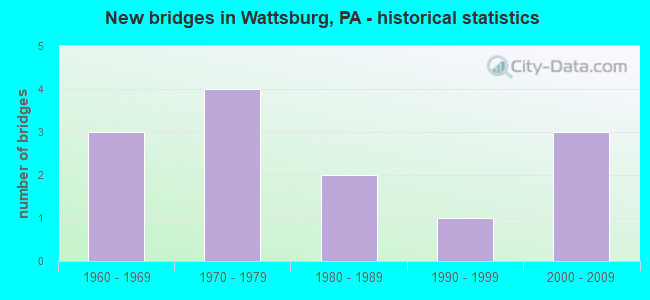
- New bridges - historical statistics
- 31960-1969
- 41970-1979
- 21980-1989
- 11990-1999
- 32000-2009


- Bridge Condition - Deck
- 9.1%Very good
- 36.4%Good
- 18.2%Satisfactory
- 36.4%Fair

- Bridge Condition - Superstructure
- 9.1%Very good
- 54.5%Good
- 9.1%Satisfactory
- 27.3%Fair

- Bridge Condition - Substructure
- 81.8%Good
- 9.1%Satisfactory
- 9.1%Fair

- Bridge Condition - Channel
- 23.1%Very good
- 15.4%Good
- 30.8%Satisfactory
- 30.8%Fair

- Bridge Condition - Culverts
- 50.0%Good
- 50.0%Satisfactory
Find on map >> Show street view
Structure Number: 1585, Location: 500' SW OF INTER./SR 0022 (Lat: 40.426533, Lng: -79.724531), Route carried "on" structure: State highway , Year Built: 1961, Status: Open, Structure Length: 0.88m (2.89ft), Average Daily Traffic: 10,996 (year 2022), Truck Traffic: 3%, Average Future Daily Traffic: 14,849 (year 2032), Design Load: HS 20, Features Intersected: THOMPSON RUN, Facility Carried by Structure: NORTHERN PIKE
Minimum Vertical Clearance: 30+ m (98+ ft), Kilometerpoint: 3.043, Lanes on structure: 2, Owner: State Highway Agency, Approaching Roadway Width: 12.2m (40.0ft), Material/Design: Concrete, Design/Construction: Slab, Number Of Spans In Main Unit: 1, Length of Maximum Span: 7.9m (25.9ft), Curb or Sidewalk Widths: Left: 0.5m (1.6ft), Right: 0.5m (1.6ft), Curb-To-Curb Width: 11.0m (36.1ft), Out-to-Out Width: 12.8m (42.0ft)
Condition: Deck: Good, Superstructure: Good, Substructure: Good, Channel: Fair, Operating Rating: 49.0 metric tons, Method Used To Determine Operating Rating: Load Factor (LF), Inventory Rating: 29.0 metric tons, Method Used To Determine Inventory Rating: Load Factor (LF), Structural Evaluation: Better than present minimum criteria, Deck Geometry: Meets minimum limits, Waterway Adequacy: Equal to present minimum criteria, Approach Roadway Alignment: Equal to present desirable criteria, Length Of Structure Improvement: 0.90m (2.95ft), Designated Inspection Frequency: Every 24 months, Inspection Date: March 2020, Deck Structure Type: Concrete Cast-file-Place, Wearing Surface/Protective System: Wearing Surface: Bituminous
Find on map >> Show street view
Structure Number: 1585, Location: WATTSBURG BOROUGH (Lat: 42.005939, Lng: -79.812186), Route carried "on" structure: State highway 8, Year Built: 1977, Status: Open, Structure Length: 5.64m (18.50ft), Average Daily Traffic: 5,344 (year 2021), Truck Traffic: 10%, Average Future Daily Traffic: 9,284 (year 2032), Design Load: HS 20, Features Intersected: OVER FRENCH CREEK W BR
Minimum Vertical Clearance: 30+ m (98+ ft), Kilometerpoint: 18.549, Lanes on structure: 2, Base Highway Network: Yes, Owner: State Highway Agency, Approaching Roadway Width: 9.8m (32.2ft), Skew: 2 degrees, Material/Design: Prestressed concrete, Design/Construction: Box Beam or Girders - Multiple, Number Of Spans In Main Unit: 2, Length of Maximum Span: 27.7m (90.9ft), Curb or Sidewalk Widths: Left: 0.2m (0.7ft), Right: 1.5m (4.9ft), Curb-To-Curb Width: 14.6m (47.9ft), Out-to-Out Width: 17.5m (57.4ft)
Condition: Deck: Satisfactory, Superstructure: Good, Substructure: Satisfactory, Channel: Satisfactory, Operating Rating: 89.8 metric tons, Method Used To Determine Operating Rating: Load Factor (LF), Inventory Rating: 57.2 metric tons, Method Used To Determine Inventory Rating: Load Factor (LF), Structural Evaluation: Equal to present minimum criteria, Deck Geometry: Superior to present desirable criteria, Waterway Adequacy: Equal to present minimum criteria, Approach Roadway Alignment: Equal to present desirable criteria, Length Of Structure Improvement: 6.60m (21.65ft), Designated Inspection Frequency: Every 48 months, Inspection Date: September 2019, Deck Structure Type: Concrete Cast-file-Place, Wearing Surface/Protective System: Wearing Surface: Bituminous, Membrane: Preformed Fabric
Find on map >> Show street view
Structure Number: 16002, Location: VENANGO TOWNSHIP (Lat: 42.036894, Lng: -79.822194), Route carried "on" structure: State highway 89, Year Built: 1983, Status: Open, Structure Length: 0.64m (2.10ft), Average Daily Traffic: 1,889 (year 2020), Truck Traffic: 12%, Average Future Daily Traffic: 2,367 (year 2032), Design Load: HS 20, Features Intersected: OVER BAILEY BROOK
Minimum Vertical Clearance: 30+ m (98+ ft), Kilometerpoint: 20.715, Lanes on structure: 2, Base Highway Network: Yes, Owner: State Highway Agency, Approaching Roadway Width: 7.6m (24.9ft), Skew: 1 degrees, Material/Design: Concrete, Design/Construction: Culvert, Number Of Spans In Main Unit: 1, Length of Maximum Span: 6.4m (21.0ft), Curb-To-Curb Width: 9.8m (32.2ft), Out-to-Out Width: 11.0m (36.1ft)
Condition: Channel: Fair, Culverts: Satisfactory, Operating Rating: 49.0 metric tons, Method Used To Determine Operating Rating: Allowable Stress (AS), Inventory Rating: 32.7 metric tons, Method Used To Determine Inventory Rating: Allowable Stress (AS), Structural Evaluation: Equal to present minimum criteria, Deck Geometry: Somewhat better than minimum adequacy, Waterway Adequacy: Equal to present minimum criteria, Approach Roadway Alignment: Equal to present desirable criteria, Length Of Structure Improvement: 1.20m (3.94ft), Designated Inspection Frequency: Every 24 months, Inspection Date: November 2021, Wearing Surface/Protective System: Wearing Surface: Bituminous
Find on map >> Show street view
Structure Number: 16178, Location: VENANGO TOWNSHIP (Lat: 42.018892, Lng: -79.763739), Route carried "on" structure: State highway 474, Year Built: 1987, Status: Open, Structure Length: 4.94m (16.21ft), Average Daily Traffic: 1,035 (year 2022), Truck Traffic: 18%, Average Future Daily Traffic: 1,739 (year 2032), Design Load: HS 25 or greater, Features Intersected: OVER FRENCH CREEK E BR
Minimum Vertical Clearance: 30+ m (98+ ft), Kilometerpoint: 4.682, Lanes on structure: 2, Owner: State Highway Agency, Approaching Roadway Width: 8.2m (26.9ft), Skew: 5 degrees, Material/Design: Steel continuous, Design/Construction: Stringer/Multi-beam, Number Of Spans In Main Unit: 2, Length of Maximum Span: 30.5m (100.1ft), Curb or Sidewalk Widths: Left: 0.2m (0.7ft), Right: 0.2m (0.7ft), Curb-To-Curb Width: 8.5m (27.9ft), Out-to-Out Width: 9.4m (30.8ft)
Condition: Deck: Good, Superstructure: Good, Substructure: Good, Channel: Good, Operating Rating: 58.1 metric tons, Method Used To Determine Operating Rating: Load Factor (LF), Inventory Rating: 34.5 metric tons, Method Used To Determine Inventory Rating: Load Factor (LF), Structural Evaluation: Better than present minimum criteria, Deck Geometry: Somewhat better than minimum adequacy, Waterway Adequacy: Equal to present minimum criteria, Approach Roadway Alignment: Equal to present desirable criteria, Length Of Structure Improvement: 5.90m (19.36ft), Designated Inspection Frequency: Every 24 months, Inspection Date: September 2021, Deck Structure Type: Concrete Cast-file-Place, Wearing Surface/Protective System: Wearing Surface: Bituminous, Membrane: Preformed Fabric, Deck Protection: Epoxy Coated Reinforcing
Find on map >> Show street view
Structure Number: 16193, Location: AMITY TOWNSHIP (Lat: 41.970542, Lng: -79.861750), Route carried "on" structure: State highway , Year Built: 1972, Status: Open, Structure Length: 9.42m (30.91ft), Average Daily Traffic: 1,325 (year 2021), Truck Traffic: 5%, Average Future Daily Traffic: 1,072 (year 2032), Design Load: HS 20, Features Intersected: OVER FRENCH CREEK N BR, Facility Carried by Structure: SR 1001,LOGAN ROAD
Minimum Vertical Clearance: 30+ m (98+ ft), Kilometerpoint: 0.974, Lanes on structure: 2, Owner: State Highway Agency, Approaching Roadway Width: 9.8m (32.2ft), Material/Design: Steel continuous, Design/Construction: Stringer/Multi-beam, Number Of Spans In Main Unit: 3, Length of Maximum Span: 36.3m (119.1ft), Curb or Sidewalk Widths: Left: 0.2m (0.7ft), Right: 0.2m (0.7ft), Curb-To-Curb Width: 12.8m (42.0ft), Out-to-Out Width: 14.0m (45.9ft)
Condition: Deck: Fair, Superstructure: Fair, Substructure: Good, Channel: Very good, Operating Rating: 61.7 metric tons, Method Used To Determine Operating Rating: Load Factor (LF), Inventory Rating: 37.2 metric tons, Method Used To Determine Inventory Rating: Load Factor (LF), Structural Evaluation: Somewhat better than minimum adequacy, Deck Geometry: Better than present minimum criteria, Waterway Adequacy: Superior to present desirable criteria, Approach Roadway Alignment: Equal to present desirable criteria, Length Of Structure Improvement: 10.40m (34.12ft), Designated Inspection Frequency: Every 24 months, Other Special Inspection Frequency: Every 6 months, Inspection Date: May 2020, Other Special Inspection Date: November 2021, Bridge Improvement Cost: $23,000, Roadway Improvement Cost: $68,000, Total Project Cost: $311,000, Deck Structure Type: Concrete Cast-file-Place, Wearing Surface/Protective System: Wearing Surface: Bituminous, Membrane: Other
Find on map >> Show street view
Structure Number: 16194, Location: AMITY TOWNSHIP (Lat: 41.982156, Lng: -79.869056), Route carried "on" structure: State highway , Year Built: 1972, Status: Open, Structure Length: 1.19m (3.90ft), Average Daily Traffic: 1,325 (year 2021), Truck Traffic: 5%, Average Future Daily Traffic: 1,072 (year 2032), Design Load: HS 20, Features Intersected: OVER PLEASANT LAKE OUTLT, Facility Carried by Structure: SR 1001,LOGAN ROAD
Minimum Vertical Clearance: 30+ m (98+ ft), Kilometerpoint: 2.477, Lanes on structure: 2, Owner: State Highway Agency, Approaching Roadway Width: 6.7m (22.0ft), Skew: 4 degrees, Material/Design: Prestressed concrete, Design/Construction: Box Beam or Girders - Single/Spread, Number Of Spans In Main Unit: 1, Length of Maximum Span: 11.3m (37.1ft), Curb-To-Curb Width: 13.1m (43.0ft), Out-to-Out Width: 14.0m (45.9ft)
Condition: Deck: Fair, Superstructure: Good, Substructure: Good, Channel: Fair, Operating Rating: 85.3 metric tons, Method Used To Determine Operating Rating: Load Factor (LF), Inventory Rating: 35.4 metric tons, Method Used To Determine Inventory Rating: Load Factor (LF), Structural Evaluation: Better than present minimum criteria, Deck Geometry: Better than present minimum criteria, Waterway Adequacy: Superior to present desirable criteria, Approach Roadway Alignment: Somewhat better than minimum adequacy, Length Of Structure Improvement: 1.80m (5.91ft), Designated Inspection Frequency: Every 24 months, Inspection Date: August 2020, Deck Structure Type: Concrete Cast-file-Place, Wearing Surface/Protective System: Wearing Surface: Bituminous, Membrane: Other
Find on map >> Show street view
Structure Number: 16273, Location: AMITY TOWNSHIP (Lat: 41.981900, Lng: -79.785203), Route carried "on" structure: State highway , Year Built: 1963, Year Reconstructed: 2009, Status: Open, Structure Length: 1.04m (3.41ft), Average Daily Traffic: 81 (year 2021), Truck Traffic: 11%, Average Future Daily Traffic: 148 (year 2032), Design Load: HS 20, Features Intersected: OVER HUBBEL RUN, Facility Carried by Structure: SR 2024,HAYES ROAD
Minimum Vertical Clearance: 30+ m (98+ ft), Kilometerpoint: 0.000, Lanes on structure: 2, Owner: State Highway Agency, Approaching Roadway Width: 8.5m (27.9ft), Skew: 1 degrees, Material/Design: Prestressed concrete, Design/Construction: Box Beam or Girders - Single/Spread, Number Of Spans In Main Unit: 1, Length of Maximum Span: 10.1m (33.1ft), Curb-To-Curb Width: 9.1m (29.9ft), Out-to-Out Width: 10.1m (33.1ft)
Condition: Deck: Very good, Superstructure: Very good, Substructure: Good, Channel: Good, Operating Rating: 51.7 metric tons, Method Used To Determine Operating Rating: Load and Resistance Factor (LRFR), Inventory Rating: 39.9 metric tons, Method Used To Determine Inventory Rating: Load and Resistance Factor (LRFR), Structural Evaluation: Better than present minimum criteria, Deck Geometry: Better than present minimum criteria, Waterway Adequacy: Better than present minimum criteria, Approach Roadway Alignment: Equal to present desirable criteria, Length Of Structure Improvement: 2.50m (8.20ft), Designated Inspection Frequency: Every 48 months, Underwater Inspection Frequency: Every 60 months, Inspection Date: May 2019, Underwater Inspection Date: October 2017, Bridge Improvement Cost: $3,000, Roadway Improvement Cost: $9,000, Total Project Cost: $41,000, Deck Structure Type: Concrete Cast-file-Place, Wearing Surface/Protective System: Wearing Surface: Monolithic Concrete, Deck Protection: Epoxy Coated Reinforcing
Find on map >> Show street view
Structure Number: 16278, Location: AMITY TOWNSHIP (Lat: 41.996817, Lng: -79.804506), Route carried "on" structure: State highway , Year Built: 1962, Status: Open, Structure Length: 1.65m (5.41ft), Average Daily Traffic: 389 (year 2022), Truck Traffic: 18%, Average Future Daily Traffic: 258 (year 2032), Design Load: H 20, Features Intersected: OVER HUBBELL RUN, Facility Carried by Structure: SR 2026,STATE LINE
Minimum Vertical Clearance: 30+ m (98+ ft), Kilometerpoint: 0.465, Lanes on structure: 2, Owner: State Highway Agency, Approaching Roadway Width: 6.4m (21.0ft), Material/Design: Steel, Design/Construction: Stringer/Multi-beam, Number Of Spans In Main Unit: 1, Length of Maximum Span: 15.8m (51.8ft), Curb or Sidewalk Widths: Left: 0.5m (1.6ft), Right: 0.5m (1.6ft), Curb-To-Curb Width: 9.8m (32.2ft), Out-to-Out Width: 11.7m (38.4ft)
Condition: Deck: Satisfactory, Superstructure: Good, Substructure: Good, Channel: Satisfactory, Operating Rating: 47.2 metric tons, Method Used To Determine Operating Rating: Load Factor (LF), Inventory Rating: 28.1 metric tons, Method Used To Determine Inventory Rating: Load Factor (LF), Structural Evaluation: Better than present minimum criteria, Deck Geometry: Better than present minimum criteria, Waterway Adequacy: Equal to present desirable criteria, Approach Roadway Alignment: Somewhat better than minimum adequacy, Length Of Structure Improvement: 2.30m (7.55ft), Designated Inspection Frequency: Every 24 months, Inspection Date: October 2020, Deck Structure Type: Concrete Cast-file-Place, Wearing Surface/Protective System: Wearing Surface: Monolithic Concrete
Find on map >> Show street view
Structure Number: 16403, Location: 1/2 MI NE OF HOPSON HILL (Lat: 41.988797, Lng: -79.858400), Route carried "on" structure: City street , Year Built: 1979, Status: Posted for load, Structure Length: 0.88m (2.89ft), Average Daily Traffic: 130 (year 2013), Truck Traffic: 4%, Average Future Daily Traffic: 141 (year 2033), Design Load: HS 20, Features Intersected: FRENCH CREEK TRIB, Facility Carried by Structure: HASKELL HILL T-559
Minimum Vertical Clearance: 30+ m (98+ ft), Kilometerpoint: 0.000, Lanes on structure: 2, Owner: Town or Township Highway Agency, Approaching Roadway Width: 5.8m (19.0ft), Material/Design: Prestressed concrete, Design/Construction: Box Beam or Girders - Multiple, Number Of Spans In Main Unit: 1, Length of Maximum Span: 8.5m (27.9ft), Curb-To-Curb Width: 7.3m (24.0ft), Out-to-Out Width: 8.5m (27.9ft)
Condition: Deck: Fair, Superstructure: Fair, Substructure: Fair, Channel: Satisfactory, Operating Rating: 47.2 metric tons, Method Used To Determine Operating Rating: Load Factor (LF), Inventory Rating: 20.0 metric tons, Method Used To Determine Inventory Rating: Load Factor (LF), Structural Evaluation: Somewhat better than minimum adequacy, Deck Geometry: Somewhat better than minimum adequacy, Waterway Adequacy: Equal to present desirable criteria, Approach Roadway Alignment: Equal to present desirable criteria, Length Of Structure Improvement: 1.00m (3.28ft), Designated Inspection Frequency: Every 24 months, Other Special Inspection Frequency: Every 12 months, Inspection Date: June 2021, Other Special Inspection Date: June 2021, Total Project Cost: $400,000, Deck Structure Type: Other, Wearing Surface/Protective System: Wearing Surface: Bituminous
Find on map >> Show street view
Structure Number: 39959, Location: 1500' EAST OF SR 0474 (Lat: 42.015392, Lng: -79.782389), Route carried "on" structure: City street , Year Built: 1997, Status: Open, Structure Length: 2.53m (8.30ft), Average Daily Traffic: 30 (year 2013), Truck Traffic: 15%, Average Future Daily Traffic: 33 (year 2033), Design Load: HS 25 or greater, Features Intersected: FRENCH CREEK, Facility Carried by Structure: T-731 TANNER ROAD
Minimum Vertical Clearance: 30+ m (98+ ft), Kilometerpoint: 0.000, Lanes on structure: 2, Owner: Town or Township Highway Agency, Approaching Roadway Width: 6.7m (22.0ft), Material/Design: Prestressed concrete, Design/Construction: Box Beam or Girders - Multiple, Number Of Spans In Main Unit: 1, Length of Maximum Span: 25.0m (82.0ft), Curb-To-Curb Width: 7.7m (25.3ft), Out-to-Out Width: 8.6m (28.2ft)
Condition: Deck: Good, Superstructure: Satisfactory, Substructure: Good, Channel: Fair, Operating Rating: 45.4 metric tons, Method Used To Determine Operating Rating: Field evaluation and documented engineering judgment, Inventory Rating: 32.7 metric tons, Method Used To Determine Inventory Rating: Field evaluation and documented engineering judgment, Structural Evaluation: Equal to present minimum criteria, Deck Geometry: Equal to present minimum criteria, Waterway Adequacy: Equal to present desirable criteria, Approach Roadway Alignment: Equal to present desirable criteria, Length Of Structure Improvement: 3.30m (10.83ft), Designated Inspection Frequency: Every 24 months, Inspection Date: September 2021, Wearing Surface/Protective System: Wearing Surface: Monolithic Concrete, Deck Protection: Epoxy Coated Reinforcing
Find on map >> Show street view
Structure Number: 42294, Location: 1500' WEST OF SR 89 (Lat: 42.033142, Lng: -79.827847), Route carried "on" structure: City street , Year Built: 2003, Status: Open, Structure Length: 2.96m (9.71ft), Average Daily Traffic: 133 (year 2013), Truck Traffic: 1%, Average Future Daily Traffic: 144 (year 2033), Design Load: HS 25 or greater, Features Intersected: W BR FRENCH CREEK, Facility Carried by Structure: T-545 HANNA HALL
Minimum Vertical Clearance: 30+ m (98+ ft), Kilometerpoint: 0.000, Lanes on structure: 2, Owner: Town or Township Highway Agency, Approaching Roadway Width: 7.0m (23.0ft), Material/Design: Prestressed concrete, Design/Construction: Box Beam or Girders - Multiple, Number Of Spans In Main Unit: 1, Length of Maximum Span: 29.0m (95.1ft), Curb or Sidewalk Widths: Left: 0.2m (0.7ft), Right: 0.2m (0.7ft), Curb-To-Curb Width: 7.8m (25.6ft), Out-to-Out Width: 8.7m (28.5ft)
Condition: Deck: Fair, Superstructure: Fair, Substructure: Good, Channel: Satisfactory, Operating Rating: 79.8 metric tons, Method Used To Determine Operating Rating: Assigned rating based on Load Factor Design (LFD) reported in metric tons, Inventory Rating: 40.8 metric tons, Method Used To Determine Inventory Rating: Assigned rating based on Load Factor Design (LFD) reported in metric tons, Structural Evaluation: Somewhat better than minimum adequacy, Deck Geometry: Somewhat better than minimum adequacy, Waterway Adequacy: Equal to present desirable criteria, Approach Roadway Alignment: Equal to present desirable criteria, Length Of Structure Improvement: 4.60m (15.09ft), Designated Inspection Frequency: Every 24 months, Inspection Date: September 2021, Deck Structure Type: Other, Wearing Surface/Protective System: Wearing Surface: Bituminous
Find on map >> Show street view
Structure Number: 44298, Location: VENANGO TOWNSHIP (Lat: 42.018931, Lng: -79.767703), Route carried "on" structure: State highway 474, Year Built: 2007, Status: Open, Structure Length: 0.76m (2.49ft), Average Daily Traffic: 1,035 (year 2022), Truck Traffic: 18%, Average Future Daily Traffic: 1,739 (year 2032), Design Load: HL 93, Features Intersected: OVER DEAN RUN
Minimum Vertical Clearance: 30+ m (98+ ft), Kilometerpoint: 3.573, Lanes on structure: 2, Owner: State Highway Agency, Approaching Roadway Width: 6.1m (20.0ft), Skew: 1 degrees, Material/Design: Concrete, Design/Construction: Culvert, Number Of Spans In Main Unit: 1, Length of Maximum Span: 6.7m (22.0ft), Curb-To-Curb Width: 8.5m (27.9ft), Out-to-Out Width: 11.4m (37.4ft)
Condition: Channel: Very good, Culverts: Good, Operating Rating: 72.6 metric tons, Method Used To Determine Operating Rating: Load and Resistance Factor (LRFR), Inventory Rating: 55.3 metric tons, Method Used To Determine Inventory Rating: Load and Resistance Factor (LRFR), Structural Evaluation: Better than present minimum criteria, Deck Geometry: Somewhat better than minimum adequacy, Waterway Adequacy: Equal to present minimum criteria, Approach Roadway Alignment: Equal to present desirable criteria, Designated Inspection Frequency: Every 48 months, Inspection Date: August 2020
Find on map >> Show street view
Structure Number: 443, Location: AMITY TOWNSHIP_ (Lat: 41.955381, Lng: -79.825844), Route carried "on" structure: State highway , Year Built: 2007, Status: Open, Structure Length: 1.10m (3.61ft), Average Daily Traffic: 165 (year 2022), Truck Traffic: 7%, Average Future Daily Traffic: 248 (year 2032), Design Load: HS 25 or greater, Features Intersected: OVER ALDER RUN, Facility Carried by Structure: SR 2034,HATCH HOLL
Minimum Vertical Clearance: 30+ m (98+ ft), Kilometerpoint: 0.000, Lanes on structure: 2, Owner: State Highway Agency, Approaching Roadway Width: 6.4m (21.0ft), Material/Design: Concrete, Design/Construction: Channel Beam, Number Of Spans In Main Unit: 1, Length of Maximum Span: 10.4m (34.1ft), Curb-To-Curb Width: 7.1m (23.3ft), Out-to-Out Width: 8.4m (27.6ft)
Condition: Deck: Good, Superstructure: Good, Substructure: Good, Channel: Very good, Operating Rating: 90.7 metric tons, Method Used To Determine Operating Rating: Load Factor (LF), Inventory Rating: 54.4 metric tons, Method Used To Determine Inventory Rating: Load Factor (LF), Structural Evaluation: Better than present minimum criteria, Deck Geometry: Meets minimum limits, Waterway Adequacy: Equal to present desirable criteria, Approach Roadway Alignment: Equal to present desirable criteria, Designated Inspection Frequency: Every 48 months, Inspection Date: May 2019, Wearing Surface/Protective System: Wearing Surface: Bituminous, Membrane: Preformed Fabric