Bridge Statistics for Watervliet, Michigan (MI)
Condition, Traffic, Stress, Structural Evaluation, Project Costs
- National Bridge Inventory (NBI) Statistics
- 10Number of bridges
- 79ft / 24.4mTotal length
- $84,000Total costs
- 104,737Total average daily traffic
- 18,686Total average daily truck traffic
- National Bridge Inventory (NBI) Registered Bridges for Watervliet
- No street view available for this location
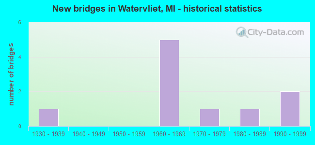
- New bridges - historical statistics
- 11930-1939
- 51960-1969
- 11970-1979
- 11980-1989
- 21990-1999

- Reconstructed bridges - Historical Statistics
- 11980-1989
- 11990-1999


- Bridge Condition - Deck
- 16.7%Good
- 50.0%Satisfactory
- 16.7%Fair
- 16.7%Poor

- Bridge Condition - Superstructure
- 83.3%Satisfactory
- 16.7%Fair

- Bridge Condition - Substructure
- 16.7%Very good
- 16.7%Good
- 50.0%Satisfactory
- 16.7%Fair

- Bridge Condition - Channel
- 20.0%Satisfactory
- 80.0%Fair
Find on map >> Show street view
Structure Number: 91, Location: 1.4 MI W OF OTSEGO (Lat: 42.460033, Lng: -85.722144), Route carried "on" structure: State highway 89, Year Built: 1930, Year Reconstructed: 1992, Status: Open, Structure Length: 6.86m (22.51ft), Average Daily Traffic: 11,469 (year 2007), Truck Traffic: 12%, Average Future Daily Traffic: 15,713 (year 2018), Design Load: HS 25 or greater, Features Intersected: KALAMAZOO RIVER
Minimum Vertical Clearance: 30.48m (100.00ft), Kilometerpoint: 13.844, Lanes on structure: 2, Base Highway Network: Yes (Inventory Route: 78, Subroute: 1), Owner: State Highway Agency, Approaching Roadway Width: 12.5m (41.0ft), Material/Design: Prestressed concrete, Design/Construction: Stringer/Multi-beam, Number Of Spans In Main Unit: 3, Length of Maximum Span: 22.9m (75.1ft), Curb-To-Curb Width: 13.4m (44.0ft), Out-to-Out Width: 14.3m (46.9ft)
Condition: Deck: Satisfactory, Superstructure: Satisfactory, Substructure: Satisfactory, Channel: Satisfactory, Operating Rating: 76.8 metric tons, Method Used To Determine Operating Rating: Load Factor (LF) rating reported by rating factor (RF) method using MS18 loading, Inventory Rating: 33.7 metric tons, Method Used To Determine Inventory Rating: Load Factor (LF) rating reported by rating factor (RF) method using MS18 loading, Structural Evaluation: Equal to present minimum criteria, Deck Geometry: Equal to present minimum criteria, Waterway Adequacy: Equal to present desirable criteria, Approach Roadway Alignment: Equal to present desirable criteria, Length Of Structure Improvement: 6.86m (22.51ft), Designated Inspection Frequency: Every 24 months, Inspection Date: July 2021, Bridge Improvement Cost: $84,000, Total Project Cost: $84,000, Deck Structure Type: Concrete Cast-file-Place, Wearing Surface/Protective System: Wearing Surface: Epoxy Overlay, Deck Protection: Epoxy Coated Reinforcing
Find on map >> Show street view
Structure Number: 852, Location: 6.6 MI E OF I-196 (Lat: 42.178100, Lng: -86.261817), Route carried "on" structure: Interstate 94, Year Built: 1960, Year Reconstructed: 1998, Status: Open, Structure Length: 4.79m (15.72ft), Average Daily Traffic: 15,032 (year 2007), Truck Traffic: 27%, Average Future Daily Traffic: 21,368 (year 2018), Design Load: HS 25 or greater, Features Intersected: M-140
Minimum Vertical Clearance: 30.48m (100.00ft), Kilometerpoint: 3.595, Lanes on structure: 3, Lanes under structure: 3, Base Highway Network: Yes (Inventory Route: 136, Subroute: 5), Owner: State Highway Agency, Approaching Roadway Width: 16.8m (55.1ft), Material/Design: Concrete continuous, Design/Construction: Tee Beam, Number Of Spans In Main Unit: 3, Length of Maximum Span: 19.4m (63.6ft), Curb-To-Curb Width: 17.5m (57.4ft), Out-to-Out Width: 18.8m (61.7ft)
Condition: Deck: Satisfactory, Superstructure: Satisfactory, Substructure: Satisfactory, Operating Rating: 57.7 metric tons, Method Used To Determine Operating Rating: Load Factor (LF) rating reported by rating factor (RF) method using MS18 loading, Inventory Rating: 21.7 metric tons, Method Used To Determine Inventory Rating: Load Factor (LF) rating reported by rating factor (RF) method using MS18 loading, Structural Evaluation: Somewhat better than minimum adequacy, Deck Geometry: Better than present minimum criteria, Underclear: Better than present minimum criteria, Approach Roadway Alignment: Equal to present desirable criteria, Designated Inspection Frequency: Every 24 months, Inspection Date: June 2020, Deck Structure Type: Concrete Cast-file-Place, Wearing Surface/Protective System: Wearing Surface: Latex Concrete
Find on map >> Show street view
Structure Number: 853, Location: 6.6 MI E OF I-196 (Lat: 42.178389, Lng: -86.261814), Route carried "on" structure: Interstate 94, Year Built: 1960, Status: Open, Structure Length: 4.79m (15.72ft), Average Daily Traffic: 15,032 (year 2007), Truck Traffic: 27%, Average Future Daily Traffic: 21,368 (year 2018), Design Load: HS 20+Mod, Features Intersected: M-140
Minimum Vertical Clearance: 30.48m (100.00ft), Kilometerpoint: 3.586, Lanes on structure: 2, Lanes under structure: 3, Base Highway Network: Yes (Inventory Route: 136, Subroute: 6), Owner: State Highway Agency, Approaching Roadway Width: 12.8m (42.0ft), Material/Design: Concrete continuous, Design/Construction: Tee Beam, Number Of Spans In Main Unit: 3, Length of Maximum Span: 19.4m (63.6ft), Curb-To-Curb Width: 12.8m (42.0ft), Out-to-Out Width: 14.6m (47.9ft)
Condition: Deck: Poor, Superstructure: Fair, Substructure: Fair, Operating Rating: 39.2 metric tons, Method Used To Determine Operating Rating: Load and Resistance Factor Rating (LRFR) rating reported by rating factor(RF) method using HL-93 loadings, Inventory Rating: 27.9 metric tons, Method Used To Determine Inventory Rating: Load and Resistance Factor Rating (LRFR) rating reported by rating factor(RF) method using HL-93 loadings, Structural Evaluation: Somewhat better than minimum adequacy, Deck Geometry: Equal to present desirable criteria, Underclear: Superior to present desirable criteria, Approach Roadway Alignment: Equal to present desirable criteria, Designated Inspection Frequency: Every 24 months, Inspection Date: June 2020, Deck Structure Type: Concrete Cast-file-Place, Wearing Surface/Protective System: Wearing Surface: Bituminous, Membrane: Preformed Fabric
Find on map >> Show street view
Structure Number: 91, Location: IN WATERVLIET (Lat: 42.193931, Lng: -86.258686), Route carried "on" structure: State highway 140, Year Built: 1996, Status: Open, Structure Length: 4.17m (13.68ft), Average Daily Traffic: 11,030 (year 2007), Truck Traffic: 3%, Average Future Daily Traffic: 12,981 (year 2018), Design Load: HS 25 or greater, Features Intersected: PAW PAW RIVER
Minimum Vertical Clearance: 30.48m (100.00ft), Kilometerpoint: 23.283, Lanes on structure: 3, Owner: State Highway Agency, Approaching Roadway Width: 14.6m (47.9ft), Skew: 2 degrees, Material/Design: Steel, Design/Construction: Stringer/Multi-beam, Number Of Spans In Main Unit: 2, Length of Maximum Span: 21.0m (68.9ft), Curb or Sidewalk Widths: Left: 1.5m (4.9ft), Right: 1.5m (4.9ft), Curb-To-Curb Width: 14.6m (47.9ft), Out-to-Out Width: 18.5m (60.7ft)
Condition: Deck: Good, Superstructure: Satisfactory, Substructure: Good, Channel: Fair, Operating Rating: 65.1 metric tons, Method Used To Determine Operating Rating: Load Factor (LF) rating reported by rating factor (RF) method using MS18 loading, Inventory Rating: 38.9 metric tons, Method Used To Determine Inventory Rating: Load Factor (LF) rating reported by rating factor (RF) method using MS18 loading, Structural Evaluation: Equal to present minimum criteria, Deck Geometry: Somewhat better than minimum adequacy, Waterway Adequacy: Equal to present minimum criteria, Approach Roadway Alignment: Better than present minimum criteria, Designated Inspection Frequency: Every 24 months, Inspection Date: June 2020, Deck Structure Type: Concrete Cast-file-Place, Wearing Surface/Protective System: Wearing Surface: Epoxy Overlay, Deck Protection: Epoxy Coated Reinforcing
Find on map >> Show street view
Structure Number: 1035, Location: 2 MI SW OF WATERVLIET (Lat: 42.173950, Lng: -86.242472), Route carried "on" structure: County highway , Year Built: 1983, Status: Posted for load, Structure Length: 0.67m (2.20ft), Average Daily Traffic: 59 (year 2007), Truck Traffic: 4%, Average Future Daily Traffic: 70 (year 2027), Design Load: H 15, Features Intersected: MILL CREEK BRANCH, Facility Carried by Structure: JOHN GOFF ROAD
Minimum Vertical Clearance: 30.48m (100.00ft), Kilometerpoint: 0.269, Lanes on structure: 2, Owner: County Highway Agency, Approaching Roadway Width: 9.8m (32.2ft), Material/Design: Wood or Timber, Design/Construction: Culvert, Number Of Spans In Main Unit: 3, Length of Maximum Span: 2.1m (6.9ft), Out-to-Out Width: 14.6m (47.9ft)
Condition: Channel: Fair, Culverts: Satisfactory, Operating Rating: 46.0 metric tons, Method Used To Determine Operating Rating: Allowable Stress (AS) rating reported by rating factor (RF) method using MS18 loading, Inventory Rating: 30.5 metric tons, Method Used To Determine Inventory Rating: Allowable Stress (AS) rating reported by rating factor (RF) method using MS18 loading, Structural Evaluation: Equal to present minimum criteria, Waterway Adequacy: Equal to present minimum criteria, Approach Roadway Alignment: Equal to present minimum criteria, Bridge Posting: Required (Relationship of Operating Rating to Maximum Legal Load: > 39.9% below), Designated Inspection Frequency: Every 24 months, Inspection Date: July 2020
Find on map >> Show street view
Structure Number: 1061, Location: 780 FT EAST OF MAIN ST (Lat: 42.187025, Lng: -86.257911), Route carried "on" structure: City street 1170, Year Built: 1992, Status: Open, Structure Length: 1.52m (4.99ft), Average Daily Traffic: 5,500 (year 1992), Truck Traffic: 4%, Average Future Daily Traffic: 7,700 (year 2012), Design Load: HS 20, Features Intersected: MILL CREEK, Facility Carried by Structure: ST JOSEPH STREET
Minimum Vertical Clearance: 30.48m (100.00ft), Kilometerpoint: 12.531, Lanes on structure: 2, Owner: City or Municipal Highway Agency, Approaching Roadway Width: 9.1m (29.9ft), Skew: 1 degrees, Material/Design: Prestressed concrete, Design/Construction: Box Beam or Girders - Multiple, Number Of Spans In Main Unit: 1, Length of Maximum Span: 14.0m (45.9ft), Curb or Sidewalk Widths: Left: 1.5m (4.9ft), Right: 1.5m (4.9ft), Curb-To-Curb Width: 8.8m (28.9ft), Out-to-Out Width: 12.6m (41.3ft)
Condition: Deck: Satisfactory, Superstructure: Satisfactory, Substructure: Very good, Channel: Fair, Operating Rating: 51.7 metric tons, Method Used To Determine Operating Rating: Allowable Stress (AS), Inventory Rating: 30.8 metric tons, Method Used To Determine Inventory Rating: Allowable Stress (AS), Structural Evaluation: Equal to present minimum criteria, Deck Geometry: High priority of replacement, Waterway Adequacy: Equal to present desirable criteria, Approach Roadway Alignment: Better than present minimum criteria, Designated Inspection Frequency: Every 24 months, Inspection Date: September 2021, Deck Structure Type: Concrete Cast-file-Place, Wearing Surface/Protective System: Wearing Surface: Monolithic Concrete, Deck Protection: Epoxy Coated Reinforcing
Find on map >> Show street view
Structure Number: 1062, Location: 470 FT EAST OF MAIN ST (Lat: 42.190433, Lng: -86.257881), Route carried "on" structure: City street , Year Built: 1976, Status: Open, Structure Length: 1.64m (5.38ft), Average Daily Traffic: 617 (year 2022), Average Future Daily Traffic: 617 (year 2042), Design Load: HS 20+Mod, Features Intersected: MILL CREEK, Facility Carried by Structure: BUTTERNUT STREET
Minimum Vertical Clearance: 30.48m (100.00ft), Kilometerpoint: 0.134, Lanes on structure: 2, Owner: City or Municipal Highway Agency, Approaching Roadway Width: 8.5m (27.9ft), Skew: 2 degrees, Material/Design: Prestressed concrete, Design/Construction: Box Beam or Girders - Multiple, Number Of Spans In Main Unit: 1, Length of Maximum Span: 16.4m (53.8ft), Curb or Sidewalk Widths: Left: 0.0m, Right: 1.6m (5.2ft), Curb-To-Curb Width: 8.5m (27.9ft), Out-to-Out Width: 11.2m (36.7ft)
Condition: Deck: Fair, Superstructure: Satisfactory, Substructure: Satisfactory, Channel: Fair, Operating Rating: 62.7 metric tons, Method Used To Determine Operating Rating: Allowable Stress (AS), Inventory Rating: 30.9 metric tons, Method Used To Determine Inventory Rating: Allowable Stress (AS), Structural Evaluation: Equal to present minimum criteria, Deck Geometry: Somewhat better than minimum adequacy, Waterway Adequacy: Better than present minimum criteria, Approach Roadway Alignment: Better than present minimum criteria, Designated Inspection Frequency: Every 24 months, Inspection Date: September 2021, Deck Structure Type: Concrete Cast-file-Place, Wearing Surface/Protective System: Wearing Surface: Bituminous
Find on map >> Show street view
Structure Number: 852, Location: 6.6 MI E OF I-196 (Lat: 42.178100, Lng: -86.261817), Route carried "under" structure: State highway 140, Year Built: 1960, Structure Length: 0. m, Average Daily Traffic: 4,816 (year 2007), Truck Traffic: 4%, Features Intersected: M-140, Facility Carried by Structure: I-94 EB
Minimum Vertical Clearance: 5.00m (16.40ft), Kilometerpoint: 21.498, Lanes on structure: 3, Lanes under structure: 3, Material/Design: Concrete continuous, Design/Construction: Tee Beam, Length of Maximum Span: 19.4m (63.6ft)
Find on map >> Show street view
Structure Number: 853, Location: 6.6 MI E OF I-196 (Lat: 42.178389, Lng: -86.261814), Route carried "under" structure: State highway 140, Year Built: 1960, Structure Length: 0. m, Average Daily Traffic: 11,118 (year 2007), Truck Traffic: 3%, Features Intersected: M-140, Facility Carried by Structure: I-94 WB
Minimum Vertical Clearance: 5.41m (17.75ft), Kilometerpoint: 21.531, Lanes on structure: 2, Lanes under structure: 3, Material/Design: Concrete continuous, Design/Construction: Tee Beam, Length of Maximum Span: 19.4m (63.6ft)
Find on map >> Show street view
Structure Number: 855, Location: 8.6 MI E OF I-196 (Lat: 42.183403, Lng: -86.223011), Route carried "under" structure: Interstate 94, Year Built: 1960, Structure Length: 0. m, Average Daily Traffic: 30,064 (year 2007), Truck Traffic: 27%, Features Intersected: I-94, Facility Carried by Structure: COUNTY LINE ROAD
Minimum Vertical Clearance: 4.85m (15.91ft), Kilometerpoint: 6.871, Lanes on structure: 2, Lanes under structure: 4, Material/Design: Concrete continuous, Design/Construction: Tee Beam, Length of Maximum Span: 22.4m (73.5ft)