Bridge Statistics for Watertown, New York (NY)
Condition, Traffic, Stress, Structural Evaluation, Project Costs
- National Bridge Inventory (NBI) Statistics
- 26Number of bridges
- 387ft / 118mTotal length
- $59,246,000Total costs
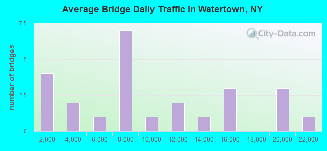
- 228,189Total average daily traffic
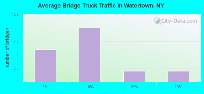
- 13,317Total average daily truck traffic
- National Bridge Inventory (NBI) Registered Bridges for Watertown
- No street view available for this location
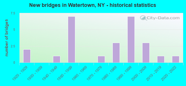
- New bridges - historical statistics
- 21920-1929
- 11940-1949
- 71950-1959
- 11970-1979
- 31980-1989
- 71990-1999
- 32000-2009
- 12010-2019
- 12020-2022
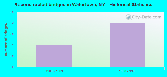
- Reconstructed bridges - Historical Statistics
- 11980-1989
- 21990-1999
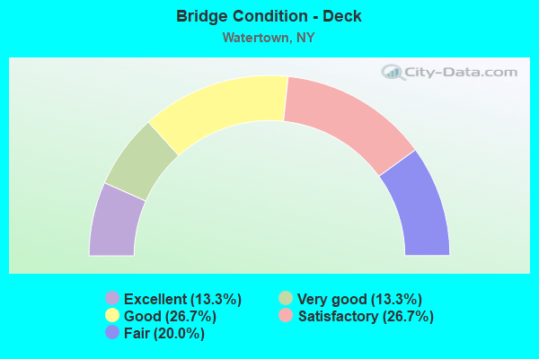
- Bridge Condition - Deck
- 13.3%Excellent
- 13.3%Very good
- 26.7%Good
- 26.7%Satisfactory
- 20.0%Fair
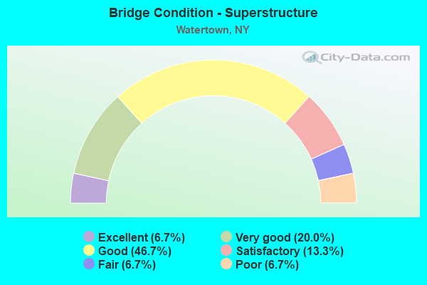
- Bridge Condition - Superstructure
- 6.7%Excellent
- 20.0%Very good
- 46.7%Good
- 13.3%Satisfactory
- 6.7%Fair
- 6.7%Poor
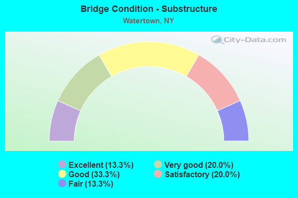
- Bridge Condition - Substructure
- 13.3%Excellent
- 20.0%Very good
- 33.3%Good
- 20.0%Satisfactory
- 13.3%Fair
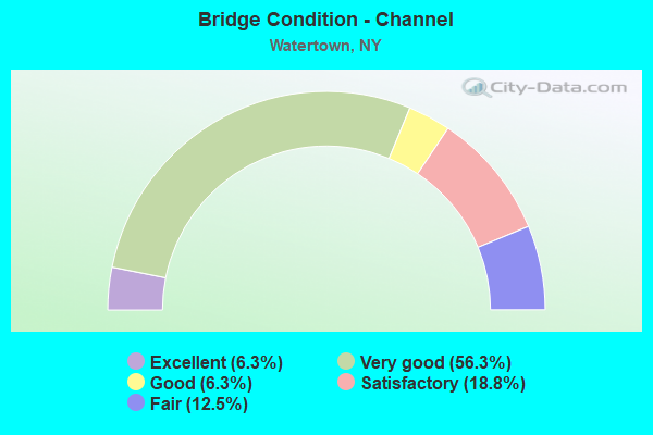
- Bridge Condition - Channel
- 6.3%Excellent
- 56.3%Very good
- 6.3%Good
- 18.8%Satisfactory
- 12.5%Fair
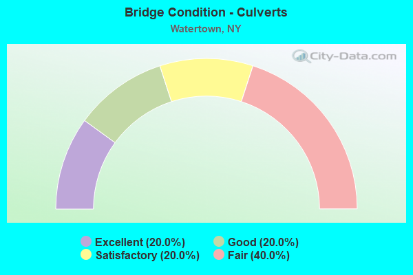
- Bridge Condition - Culverts
- 20.0%Excellent
- 20.0%Good
- 20.0%Satisfactory
- 40.0%Fair
Find on map >> Show street view
Structure Number: 100049, Location: JCT RTE 3 + I-81 (Lat: 43.975747, Lng: -75.948342), Route carried "on" structure: State highway 3, Year Built: 2008, Status: Open, Structure Length: 6.31m (20.70ft), Average Daily Traffic: 19,685 (year 2017), Truck Traffic: 6%, Average Future Daily Traffic: 19,777 (year 2040), Design Load: HL 93, Features Intersected: RTE I81, RTE I81
Minimum Vertical Clearance: 30+ m (98+ ft), Kilometerpoint: 46.918, Lanes on structure: 7, Lanes under structure: 5, Base Highway Network: Yes, Owner: State Highway Agency, Approaching Roadway Width: 27.1m (88.9ft), Skew: 1 degrees, Material/Design: Steel continuous, Design/Construction: Stringer/Multi-beam, Number Of Spans In Main Unit: 2, Length of Maximum Span: 35.4m (116.1ft), Curb or Sidewalk Widths: Left: 1.7m (5.6ft), Right: 1.7m (5.6ft), Curb-To-Curb Width: 27.5m (90.2ft), Out-to-Out Width: 30.9m (101.4ft)
Condition: Deck: Very good, Superstructure: Very good, Substructure: Excellent, Operating Rating: 88.0 metric tons, Method Used To Determine Operating Rating: Load Factor (LF), Inventory Rating: 52.6 metric tons, Method Used To Determine Inventory Rating: Load Factor (LF), Structural Evaluation: Equal to present desirable criteria, Deck Geometry: Somewhat better than minimum adequacy, Underclear: Meets minimum limits, Approach Roadway Alignment: Equal to present desirable criteria, Length Of Structure Improvement: 6.30m (20.67ft), Designated Inspection Frequency: Every 24 months, Inspection Date: September 2020, Bridge Improvement Cost: $3,760,000, Roadway Improvement Cost: $2,202,000, Total Project Cost: $5,962,000 ( Estimate for 2021), Deck Structure Type: Concrete Cast-file-Place, Wearing Surface/Protective System: Wearing Surface: Integral Concrete, Deck Protection: Epoxy Coated Reinforcing
Find on map >> Show street view
Structure Number: 10005, Location: .3 MI W JCT SH 3 & SH 12 (Lat: 43.976344, Lng: -75.923175), Route carried "on" structure: State highway 3, Year Built: 2020, Status: Open, Structure Length: 6.86m (22.51ft), Average Daily Traffic: 18,613 (year 2020), Truck Traffic: 2%, Average Future Daily Traffic: 18,700 (year 2040), Design Load: HL 93, Features Intersected: EXCHANGE STREET, CSX Spu
Minimum Vertical Clearance: 32.69m (107.25ft), Kilometerpoint: 48.946, Lanes on structure: 4, Lanes under structure: 4, Owner: State Highway Agency, Approaching Roadway Width: 15.2m (49.9ft), Skew: 3 degrees, Material/Design: Steel continuous, Design/Construction: Stringer/Multi-beam, Number Of Spans In Main Unit: 2, Length of Maximum Span: 33.5m (109.9ft), Curb or Sidewalk Widths: Left: 1.5m (4.9ft), Right: 1.5m (4.9ft), Curb-To-Curb Width: 15.2m (49.9ft), Out-to-Out Width: 19.6m (64.3ft)
Condition: Deck: Excellent, Superstructure: Excellent, Substructure: Excellent, Operating Rating: 81.6 metric tons, Method Used To Determine Operating Rating: Load Factor (LF), Inventory Rating: 49.0 metric tons, Method Used To Determine Inventory Rating: Load Factor (LF), Structural Evaluation: Superior to present desirable criteria, Deck Geometry: High priority of corrective action, Underclear: Somewhat better than minimum adequacy, Approach Roadway Alignment: Equal to present desirable criteria, Length Of Structure Improvement: 6.85m (22.47ft), Designated Inspection Frequency: Every 24 months, Inspection Date: May 2021, Bridge Improvement Cost: $3,187,000, Roadway Improvement Cost: $1,866,000, Total Project Cost: $5,054,000 ( Estimate for 2021), Deck Structure Type: Concrete Cast-file-Place, Wearing Surface/Protective System: Wearing Surface: Integral Concrete, Deck Protection: Other Coated Reinforcing
Find on map >> Show street view
Structure Number: 100967, Location: 1 MILE SE JCT I81 & SH 12 (Lat: 43.990656, Lng: -75.915528), Route carried "on" structure: State highway 12, Year Built: 1957, Status: Open, Structure Length: 1.01m (3.31ft), Average Daily Traffic: 6,965 (year 2020), Truck Traffic: 7%, Average Future Daily Traffic: 8,461 (year 2040), Design Load: H 20, Features Intersected: KELSEY CREEK
Minimum Vertical Clearance: 30+ m (98+ ft), Kilometerpoint: 22.606, Lanes on structure: 4, Base Highway Network: Yes, Owner: State Highway Agency, Approaching Roadway Width: 13.4m (44.0ft), Material/Design: Concrete continuous, Design/Construction: Frame, Number Of Spans In Main Unit: 2, Length of Maximum Span: 4.5m (14.8ft), Curb or Sidewalk Widths: Left: 2.7m (8.9ft), Right: 2.7m (8.9ft), Curb-To-Curb Width: 13.4m (44.0ft), Out-to-Out Width: 19.5m (64.0ft)
Condition: Deck: Fair, Superstructure: Fair, Substructure: Fair, Channel: Satisfactory, Operating Rating: 60.8 metric tons, Method Used To Determine Operating Rating: Load Factor (LF), Inventory Rating: 36.3 metric tons, Method Used To Determine Inventory Rating: Load Factor (LF), Structural Evaluation: Somewhat better than minimum adequacy, Deck Geometry: High priority of replacement, Waterway Adequacy: Somewhat better than minimum adequacy, Approach Roadway Alignment: Equal to present desirable criteria, Length Of Structure Improvement: 1.00m (3.28ft), Designated Inspection Frequency: Every 24 months, Inspection Date: April 2021, Bridge Improvement Cost: $821,000, Roadway Improvement Cost: $481,000, Total Project Cost: $1,302,000 ( Estimate for 2021), Wearing Surface/Protective System: Wearing Surface: Bituminous
Find on map >> Show street view
Structure Number: 101017, Location: JCT OF RTE 12F & RTE I-81 (Lat: 43.988817, Lng: -75.944272), Route carried "on" structure: Business State highway 12F, Year Built: 1993, Status: Open, Structure Length: 6.83m (22.41ft), Average Daily Traffic: 14,199 (year 2018), Truck Traffic: 5%, Average Future Daily Traffic: 17,248 (year 2040), Design Load: HS 25 or greater, Features Intersected: RTE I81, RTE I81
Minimum Vertical Clearance: 30+ m (98+ ft), Kilometerpoint: 8.479, Lanes on structure: 2, Lanes under structure: 4, Base Highway Network: Yes, Owner: State Highway Agency, Approaching Roadway Width: 15.8m (51.8ft), Skew: 1 degrees, Material/Design: Steel continuous, Design/Construction: Stringer/Multi-beam, Number Of Spans In Main Unit: 2, Length of Maximum Span: 35.9m (117.8ft), Curb-To-Curb Width: 15.8m (51.8ft), Out-to-Out Width: 16.8m (55.1ft)
Condition: Deck: Satisfactory, Superstructure: Good, Substructure: Very good, Operating Rating: 89.8 metric tons, Method Used To Determine Operating Rating: Load Factor (LF), Inventory Rating: 45.4 metric tons, Method Used To Determine Inventory Rating: Load Factor (LF), Structural Evaluation: Better than present minimum criteria, Deck Geometry: Superior to present desirable criteria, Underclear: High priority of corrective action, Approach Roadway Alignment: Equal to present desirable criteria, Length Of Structure Improvement: 6.82m (22.38ft), Designated Inspection Frequency: Every 24 months, Inspection Date: August 2021, Bridge Improvement Cost: $1,955,000, Roadway Improvement Cost: $1,145,000, Total Project Cost: $3,100,000 ( Estimate for 2021), Deck Structure Type: Concrete Cast-file-Place, Wearing Surface/Protective System: Wearing Surface: Integral Concrete, Deck Protection: Epoxy Coated Reinforcing
Find on map >> Show street view
Structure Number: 103216, Location: 1.5 MI S JCT I-81 + 3 (Lat: 43.953222, Lng: -75.954894), Route carried "on" structure: Interstate 81, Year Built: 1957, Status: Open, Structure Length: 0.76m (2.49ft), Average Daily Traffic: 15,952 (year 2019), Truck Traffic: 19%, Average Future Daily Traffic: 20,817 (year 2040), Design Load: HS 20, Features Intersected: BEAVER MEADOW CK
Minimum Vertical Clearance: 30+ m (98+ ft), Kilometerpoint: 33.644, Lanes on structure: 4, Base Highway Network: Yes, Owner: State Highway Agency, Approaching Roadway Width: 21.9m (71.9ft), Skew: 23 degrees, Material/Design: Concrete continuous, Design/Construction: Culvert, Number Of Spans In Main Unit: 2, Length of Maximum Span: 3.7m (12.1ft)
Condition: Channel: Satisfactory, Culverts: Satisfactory, Structural Evaluation: Equal to present minimum criteria, Waterway Adequacy: Superior to present desirable criteria, Approach Roadway Alignment: Equal to present desirable criteria, Length Of Structure Improvement: 0.76m (2.49ft), Designated Inspection Frequency: Every 24 months, Inspection Date: April 2020, Bridge Improvement Cost: $584,000, Roadway Improvement Cost: $342,000, Total Project Cost: $927,000 ( Estimate for 2021), Wearing Surface/Protective System: Wearing Surface: Bituminous
Find on map >> Show street view
Structure Number: 103217, Location: 1 MILE S JCT I81 & SH 3 (Lat: 43.959822, Lng: -75.951722), Route carried "on" structure: County highway , Year Built: 1959, Status: Open, Structure Length: 11.06m (36.29ft), Average Daily Traffic: 676 (year 2018), Truck Traffic: 3%, Average Future Daily Traffic: 830 (year 2040), Design Load: HS 20, Features Intersected: RTE I81, RTE I81, Facility Carried by Structure: COUNTY ROAD 63
Minimum Vertical Clearance: 30+ m (98+ ft), Kilometerpoint: 15.929, Lanes on structure: 2, Lanes under structure: 4, Owner: State Highway Agency, Approaching Roadway Width: 8.2m (26.9ft), Skew: 5 degrees, Material/Design: Steel, Design/Construction: Stringer/Multi-beam, Number Of Spans In Main Unit: 5, Length of Maximum Span: 23.4m (76.8ft), Curb or Sidewalk Widths: Left: 0.5m (1.6ft), Right: 0.5m (1.6ft), Curb-To-Curb Width: 7.9m (25.9ft), Out-to-Out Width: 9.5m (31.2ft)
Condition: Deck: Good, Superstructure: Good, Substructure: Good, Operating Rating: 59.0 metric tons, Method Used To Determine Operating Rating: Load Factor (LF), Inventory Rating: 35.4 metric tons, Method Used To Determine Inventory Rating: Load Factor (LF), Structural Evaluation: Better than present minimum criteria, Deck Geometry: Somewhat better than minimum adequacy, Underclear: High priority of corrective action, Approach Roadway Alignment: Equal to present desirable criteria, Length Of Structure Improvement: 11.06m (36.29ft), Designated Inspection Frequency: Every 24 months, Inspection Date: October 2021, Bridge Improvement Cost: $2,025,000, Roadway Improvement Cost: $1,186,000, Total Project Cost: $3,210,000 ( Estimate for 2021), Deck Structure Type: Concrete Cast-file-Place, Wearing Surface/Protective System: Wearing Surface: Integral Concrete
Find on map >> Show street view
Structure Number: 1032181, Location: JCT RTE I-81 SB + BLACK R (Lat: 43.995831, Lng: -75.933778), Route carried "on" structure: Interstate 81, Year Built: 1959, Year Reconstructed: 2004, Status: Open, Structure Length: 10.91m (35.79ft), Average Daily Traffic: 12,167 (year 2009), Truck Traffic: 16%, Design Load: HS 20, Features Intersected: BLACK RIVER
Minimum Vertical Clearance: 30+ m (98+ ft), Kilometerpoint: 38.890, Lanes on structure: 2, Base Highway Network: Yes, Owner: State Highway Agency, Approaching Roadway Width: 10.4m (34.1ft), Skew: 1 degrees, Material/Design: Steel continuous, Design/Construction: Stringer/Multi-beam, Number Of Spans In Main Unit: 4, Length of Maximum Span: 28.6m (93.8ft), Curb-To-Curb Width: 10.2m (33.5ft), Out-to-Out Width: 11.2m (36.7ft)
Condition: Deck: Satisfactory, Superstructure: Good, Substructure: Satisfactory, Channel: Very good, Operating Rating: 79.8 metric tons, Method Used To Determine Operating Rating: Load Factor (LF), Inventory Rating: 48.1 metric tons, Method Used To Determine Inventory Rating: Load Factor (LF), Structural Evaluation: Equal to present minimum criteria, Deck Geometry: Meets minimum limits, Waterway Adequacy: Equal to present desirable criteria, Approach Roadway Alignment: Equal to present desirable criteria, Length Of Structure Improvement: 10.91m (35.79ft), Designated Inspection Frequency: Every 24 months, Underwater Inspection Frequency: Every 60 months, Inspection Date: October 2021, Underwater Inspection Date: September 2018, Bridge Improvement Cost: $2,849,000, Roadway Improvement Cost: $1,669,000, Total Project Cost: $4,518,000 ( Estimate for 2021), Deck Structure Type: Concrete Cast-file-Place, Wearing Surface/Protective System: Wearing Surface: Integral Concrete
Find on map >> Show street view
Structure Number: 1032182, Location: JCT RTE I-81 NB + BLACK R (Lat: 43.995656, Lng: -75.933689), Route carried "on" structure: Interstate 81, Year Built: 1959, Year Reconstructed: 2003, Status: Open, Structure Length: 10.88m (35.70ft), Average Daily Traffic: 10,843 (year 2019), Truck Traffic: 14%, Average Future Daily Traffic: 14,150 (year 2040), Design Load: HS 20, Features Intersected: BLACK RIVER
Minimum Vertical Clearance: 30+ m (98+ ft), Kilometerpoint: 38.890, Lanes on structure: 2, Base Highway Network: Yes, Owner: State Highway Agency, Approaching Roadway Width: 11.3m (37.1ft), Skew: 1 degrees, Material/Design: Steel continuous, Design/Construction: Stringer/Multi-beam, Number Of Spans In Main Unit: 4, Length of Maximum Span: 28.6m (93.8ft), Curb-To-Curb Width: 10.2m (33.5ft), Out-to-Out Width: 11.2m (36.7ft)
Condition: Deck: Good, Superstructure: Good, Substructure: Satisfactory, Channel: Very good, Operating Rating: 79.8 metric tons, Method Used To Determine Operating Rating: Load Factor (LF), Inventory Rating: 48.1 metric tons, Method Used To Determine Inventory Rating: Load Factor (LF), Structural Evaluation: Equal to present minimum criteria, Deck Geometry: Meets minimum limits, Waterway Adequacy: Equal to present desirable criteria, Approach Roadway Alignment: Equal to present desirable criteria, Length Of Structure Improvement: 10.88m (35.70ft), Designated Inspection Frequency: Every 24 months, Underwater Inspection Frequency: Every 60 months, Inspection Date: October 2021, Underwater Inspection Date: September 2018, Bridge Improvement Cost: $2,844,000, Roadway Improvement Cost: $1,665,000, Total Project Cost: $4,509,000 ( Estimate for 2021), Deck Structure Type: Concrete Cast-file-Place, Wearing Surface/Protective System: Wearing Surface: Integral Concrete, Deck Protection: Epoxy Coated Reinforcing
Find on map >> Show street view
Structure Number: 107448, Location: WATERTOWN STATE&GIFFORD (Lat: 43.964753, Lng: -75.875133), Route carried "on" structure: State highway 12, Year Built: 1990, Status: Open, Structure Length: 1.28m (4.20ft), Average Daily Traffic: 8,632 (year 2020), Truck Traffic: 8%, Average Future Daily Traffic: 8,672 (year 2040), Design Load: HS 20, Features Intersected: COLD CREEK
Minimum Vertical Clearance: 30+ m (98+ ft), Kilometerpoint: 17.377, Lanes on structure: 2, Base Highway Network: Yes, Owner: State Highway Agency, Approaching Roadway Width: 12.2m (40.0ft), Skew: 2 degrees, Material/Design: Concrete, Design/Construction: Culvert, Number Of Spans In Main Unit: 2, Length of Maximum Span: 5.7m (18.7ft), Curb or Sidewalk Widths: Left: 3.2m (10.5ft), Right: 0.4m (1.3ft), Curb-To-Curb Width: 12.2m (40.0ft), Out-to-Out Width: 16.3m (53.5ft)
Condition: Channel: Fair, Culverts: Fair, Operating Rating: 76.7 metric tons, Method Used To Determine Operating Rating: Field evaluation and documented engineering judgment, Inventory Rating: 32.7 metric tons, Method Used To Determine Inventory Rating: Field evaluation and documented engineering judgment, Structural Evaluation: Somewhat better than minimum adequacy, Deck Geometry: Somewhat better than minimum adequacy, Waterway Adequacy: Meets minimum limits, Approach Roadway Alignment: Equal to present desirable criteria, Length Of Structure Improvement: 1.28m (4.20ft), Designated Inspection Frequency: Every 24 months, Inspection Date: April 2021, Bridge Improvement Cost: $418,000, Roadway Improvement Cost: $245,000, Total Project Cost: $663,000 ( Estimate for 2021), Wearing Surface/Protective System: Wearing Surface: Integral Concrete
Find on map >> Show street view
Structure Number: 107449, Location: WATERTOWN JCT STATE&HUNT (Lat: 43.965775, Lng: -75.875756), Route carried "on" structure: State highway 12, Year Built: 1990, Status: Open, Structure Length: 1.04m (3.41ft), Average Daily Traffic: 4,923 (year 2020), Truck Traffic: 10%, Average Future Daily Traffic: 4,946 (year 2040), Design Load: HS 20, Features Intersected: COLD CREEK
Minimum Vertical Clearance: 30+ m (98+ ft), Kilometerpoint: 17.232, Lanes on structure: 3, Base Highway Network: Yes, Owner: State Highway Agency, Approaching Roadway Width: 11.9m (39.0ft), Material/Design: Concrete, Design/Construction: Culvert, Number Of Spans In Main Unit: 2, Length of Maximum Span: 4.6m (15.1ft), Curb or Sidewalk Widths: Left: 2.4m (7.9ft), Right: 2.5m (8.2ft), Curb-To-Curb Width: 11.8m (38.7ft), Out-to-Out Width: 17.3m (56.8ft)
Condition: Channel: Fair, Culverts: Fair, Operating Rating: 75.8 metric tons, Method Used To Determine Operating Rating: Field evaluation and documented engineering judgment, Inventory Rating: 32.7 metric tons, Method Used To Determine Inventory Rating: Field evaluation and documented engineering judgment, Structural Evaluation: Somewhat better than minimum adequacy, Deck Geometry: High priority of corrective action, Waterway Adequacy: Meets minimum limits, Approach Roadway Alignment: Equal to present desirable criteria, Length Of Structure Improvement: 1.03m (3.38ft), Designated Inspection Frequency: Every 24 months, Inspection Date: April 2021, Bridge Improvement Cost: $358,000, Roadway Improvement Cost: $210,000, Total Project Cost: $568,000 ( Estimate for 2021), Wearing Surface/Protective System: Wearing Surface: Integral Concrete
Find on map >> Show street view
Structure Number: 107987, Location: 0.3 MI SOUTH RTE 232 Int. (Lat: 43.927408, Lng: -75.940692), Route carried "on" structure: US 11, Year Built: 2017, Status: Open, Structure Length: 0.82m (2.69ft), Average Daily Traffic: 3,204 (year 2020), Truck Traffic: 9%, Average Future Daily Traffic: 3,964 (year 2040), Design Load: HL 93, Features Intersected: Mill Creek
Minimum Vertical Clearance: 32.69m (107.25ft), Kilometerpoint: 32.019, Lanes on structure: 2, Owner: State Highway Agency, Approaching Roadway Width: 12.2m (40.0ft), Skew: 2 degrees, Material/Design: Concrete, Design/Construction: Culvert, Number Of Spans In Main Unit: 1, Length of Maximum Span: 7.6m (24.9ft)
Condition: Channel: Very good, Culverts: Excellent, Inventory Rating: 67.1 metric tons, Method Used To Determine Inventory Rating: Load Factor (LF), Structural Evaluation: Superior to present desirable criteria, Waterway Adequacy: Equal to present desirable criteria, Approach Roadway Alignment: Equal to present desirable criteria, Length Of Structure Improvement: 0.82m (2.69ft), Designated Inspection Frequency: Every 24 months, Inspection Date: November 2021, Bridge Improvement Cost: $301,000, Roadway Improvement Cost: $176,000, Total Project Cost: $478,000 ( Estimate for 2021)
Find on map >> Show street view
Structure Number: 222021, Location: 0.5MI NW OF RTE11&BLACK R (Lat: 43.984661, Lng: -75.925181), Route carried "on" structure: ServiceCity street , Year Built: 1993, Status: Open, Structure Length: 11.80m (38.71ft), Average Daily Traffic: 3,170 (year 2018), Truck Traffic: 5%, Average Future Daily Traffic: 3,922 (year 2040), Design Load: HS 20, Features Intersected: BLACK RIVER, Facility Carried by Structure: VAN DUZEE STREET
Minimum Vertical Clearance: 30+ m (98+ ft), Kilometerpoint: 0.225, Lanes on structure: 2, Owner: City or Municipal Highway Agency, Approaching Roadway Width: 8.5m (27.9ft), Skew: 4 degrees, Material/Design: Steel continuous, Design/Construction: Stringer/Multi-beam, Number Of Spans In Main Unit: 3, Length of Maximum Span: 44.1m (144.7ft), Curb or Sidewalk Widths: Left: 0.0m, Right: 1.8m (5.9ft), Curb-To-Curb Width: 8.5m (27.9ft), Out-to-Out Width: 10.7m (35.1ft)
Condition: Deck: Fair, Superstructure: Good, Substructure: Good, Channel: Good, Operating Rating: 63.5 metric tons, Method Used To Determine Operating Rating: Load Factor (LF), Inventory Rating: 32.7 metric tons, Method Used To Determine Inventory Rating: Load Factor (LF), Structural Evaluation: Better than present minimum criteria, Deck Geometry: Meets minimum limits, Waterway Adequacy: Equal to present minimum criteria, Approach Roadway Alignment: Equal to present desirable criteria, Length Of Structure Improvement: 11.79m (38.68ft), Designated Inspection Frequency: Every 24 months, Underwater Inspection Frequency: Every 60 months, Inspection Date: May 2021, Underwater Inspection Date: September 2018, Bridge Improvement Cost: $2,368,000, Roadway Improvement Cost: $1,386,000, Total Project Cost: $3,754,000 ( Estimate for 2021), Deck Structure Type: Concrete Cast-file-Place, Wearing Surface/Protective System: Wearing Surface: Integral Concrete, Deck Protection: Epoxy Coated Reinforcing
Find on map >> Show street view
Structure Number: 222022, Location: IN WATERTOWN (Lat: 43.980547, Lng: -75.914250), Route carried "on" structure: City street , Year Built: 1993, Status: Open, Structure Length: 14.75m (48.39ft), Average Daily Traffic: 15,947 (year 2011), Truck Traffic: 6%, Average Future Daily Traffic: 16,021 (year 2040), Design Load: HS 20, Features Intersected: CITY CENTER DRIVE, BLACK, Facility Carried by Structure: U.S. Route 11
Minimum Vertical Clearance: 30+ m (98+ ft), Kilometerpoint: 0.579, Lanes on structure: 4, Lanes under structure: 4, Owner: City or Municipal Highway Agency, Approaching Roadway Width: 15.8m (51.8ft), Material/Design: Steel continuous, Design/Construction: Stringer/Multi-beam, Number Of Spans In Main Unit: 2, Length of Maximum Span: 74.6m (244.8ft), Curb or Sidewalk Widths: Left: 1.5m (4.9ft), Right: 1.5m (4.9ft), Curb-To-Curb Width: 15.8m (51.8ft), Out-to-Out Width: 19.5m (64.0ft)
Condition: Deck: Good, Superstructure: Satisfactory, Substructure: Good, Channel: Very good, Inventory Rating: 43.5 metric tons, Method Used To Determine Inventory Rating: Allowable Stress (AS), Structural Evaluation: Equal to present minimum criteria, Deck Geometry: Meets minimum limits, Underclear: Somewhat better than minimum adequacy, Waterway Adequacy: Equal to present minimum criteria, Approach Roadway Alignment: Equal to present desirable criteria, Length Of Structure Improvement: 14.75m (48.39ft), Designated Inspection Frequency: Every 24 months, Inspection Date: November 2021, Bridge Improvement Cost: $5,649,000, Roadway Improvement Cost: $3,308,000, Total Project Cost: $8,956,000 ( Estimate for 2021), Deck Structure Type: Concrete Cast-file-Place, Wearing Surface/Protective System: Wearing Surface: Integral Concrete, Deck Protection: Epoxy Coated Reinforcing
Find on map >> Show street view
Structure Number: 222023, Location: IN WATERTOWN (Lat: 43.976033, Lng: -75.907603), Route carried "on" structure: US 11, Year Built: 1928, Year Reconstructed: 1989, Status: Open, Structure Length: 1.52m (4.99ft), Average Daily Traffic: 6,848 (year 2018), Truck Traffic: 4%, Average Future Daily Traffic: 6,880 (year 2040), Design Load: HS 20, Features Intersected: BLACK RI OVERFLOW
Minimum Vertical Clearance: 30+ m (98+ ft), Kilometerpoint: 38.584, Lanes on structure: 2, Base Highway Network: Yes, Owner: City or Municipal Highway Agency, Approaching Roadway Width: 12.2m (40.0ft), Material/Design: Prestressed concrete, Design/Construction: Box Beam or Girders - Multiple, Number Of Spans In Main Unit: 1, Length of Maximum Span: 14.3m (46.9ft), Curb or Sidewalk Widths: Left: 1.9m (6.2ft), Right: 1.9m (6.2ft), Curb-To-Curb Width: 12.2m (40.0ft), Out-to-Out Width: 16.5m (54.1ft)
Condition: Deck: Satisfactory, Superstructure: Very good, Substructure: Good, Channel: Very good, Operating Rating: 63.8 metric tons, Method Used To Determine Operating Rating: Load and Resistance Factor Rating (LRFR) rating reported by rating factor(RF) method using HL-93 loadings, Inventory Rating: 39.9 metric tons, Method Used To Determine Inventory Rating: Load and Resistance Factor Rating (LRFR) rating reported by rating factor(RF) method using HL-93 loadings, Structural Evaluation: Better than present minimum criteria, Deck Geometry: Somewhat better than minimum adequacy, Waterway Adequacy: Superior to present desirable criteria, Approach Roadway Alignment: Equal to present desirable criteria, Length Of Structure Improvement: 1.52m (4.99ft), Designated Inspection Frequency: Every 24 months, Inspection Date: May 2020, Bridge Improvement Cost: $978,000, Roadway Improvement Cost: $573,000, Total Project Cost: $1,551,000 ( Estimate for 2021), Deck Structure Type: Concrete Cast-file-Place, Wearing Surface/Protective System: Wearing Surface: Integral Concrete
Find on map >> Show street view
Structure Number: 222024, Location: MILL ST RT11 WATERTOWN (Lat: 43.977181, Lng: -75.907294), Route carried "on" structure: US 11, Year Built: 1989, Status: Open, Structure Length: 4.79m (15.72ft), Average Daily Traffic: 6,848 (year 2018), Truck Traffic: 4%, Average Future Daily Traffic: 6,880 (year 2040), Design Load: HS 20, Features Intersected: BLACK RIVER
Minimum Vertical Clearance: 30+ m (98+ ft), Kilometerpoint: 38.729, Lanes on structure: 2, Base Highway Network: Yes, Owner: City or Municipal Highway Agency, Approaching Roadway Width: 11.6m (38.1ft), Material/Design: Steel, Design/Construction: Stringer/Multi-beam, Number Of Spans In Main Unit: 1, Length of Maximum Span: 47.2m (154.9ft), Curb or Sidewalk Widths: Left: 1.5m (4.9ft), Right: 1.5m (4.9ft), Curb-To-Curb Width: 11.4m (37.4ft), Out-to-Out Width: 15.6m (51.2ft)
Condition: Deck: Satisfactory, Superstructure: Good, Substructure: Satisfactory, Channel: Very good, Operating Rating: 71.6 metric tons, Method Used To Determine Operating Rating: Load and Resistance Factor Rating (LRFR) rating reported by rating factor(RF) method using HL-93 loadings, Inventory Rating: 55.4 metric tons, Method Used To Determine Inventory Rating: Load and Resistance Factor Rating (LRFR) rating reported by rating factor(RF) method using HL-93 loadings, Structural Evaluation: Equal to present minimum criteria, Deck Geometry: Meets minimum limits, Waterway Adequacy: Superior to present desirable criteria, Approach Roadway Alignment: Equal to present desirable criteria, Length Of Structure Improvement: 4.78m (15.68ft), Designated Inspection Frequency: Every 24 months, Inspection Date: May 2020, Bridge Improvement Cost: $2,306,000, Roadway Improvement Cost: $1,351,000, Total Project Cost: $3,657,000 ( Estimate for 2021), Deck Structure Type: Concrete Cast-file-Place, Wearing Surface/Protective System: Wearing Surface: Integral Concrete, Deck Protection: Epoxy Coated Reinforcing
Find on map >> Show street view
Structure Number: 222025, Location: IN WATERTOWN (Lat: 43.978203, Lng: -75.898272), Route carried "on" structure: City street 283, Year Built: 2004, Status: Open, Structure Length: 5.03m (16.50ft), Average Daily Traffic: 7,137 (year 2020), Truck Traffic: 4%, Average Future Daily Traffic: 8,670 (year 2040), Design Load: HS 25 or greater, Features Intersected: S.BR. BLACK RIVER
Minimum Vertical Clearance: 30+ m (98+ ft), Kilometerpoint: 0.837, Lanes on structure: 2, Base Highway Network: Yes, Owner: City or Municipal Highway Agency, Approaching Roadway Width: 9.4m (30.8ft), Material/Design: Steel, Design/Construction: Stringer/Multi-beam, Number Of Spans In Main Unit: 1, Length of Maximum Span: 49.5m (162.4ft), Curb or Sidewalk Widths: Left: 1.8m (5.9ft), Right: 0.0m, Curb-To-Curb Width: 9.3m (30.5ft), Out-to-Out Width: 11.9m (39.0ft)
Condition: Deck: Very good, Superstructure: Good, Substructure: Very good, Channel: Excellent, Inventory Rating: 69.9 metric tons, Method Used To Determine Inventory Rating: Load Factor (LF), Structural Evaluation: Better than present minimum criteria, Deck Geometry: High priority of corrective action, Waterway Adequacy: Equal to present desirable criteria, Approach Roadway Alignment: Equal to present minimum criteria, Length Of Structure Improvement: 5.02m (16.47ft), Designated Inspection Frequency: Every 24 months, Inspection Date: October 2020, Bridge Improvement Cost: $1,352,000, Roadway Improvement Cost: $792,000, Total Project Cost: $2,144,000 ( Estimate for 2021), Deck Structure Type: Concrete Cast-file-Place, Wearing Surface/Protective System: Wearing Surface: Integral Concrete, Deck Protection: Epoxy Coated Reinforcing
Find on map >> Show street view
Structure Number: 222026, Location: IN WATERTOWN (Lat: 43.979347, Lng: -75.896592), Route carried "on" structure: State highway 283, Year Built: 1978, Status: Open, Structure Length: 2.80m (9.19ft), Average Daily Traffic: 7,137 (year 2020), Truck Traffic: 4%, Average Future Daily Traffic: 8,670 (year 2040), Design Load: HS 20, Features Intersected: N BR BLACK RIVER
Minimum Vertical Clearance: 30+ m (98+ ft), Kilometerpoint: 1.014, Lanes on structure: 2, Base Highway Network: Yes, Owner: City or Municipal Highway Agency, Approaching Roadway Width: 9.1m (29.9ft), Skew: 2 degrees, Material/Design: Prestressed concrete, Design/Construction: Box Beam or Girders - Multiple, Number Of Spans In Main Unit: 1, Length of Maximum Span: 25.2m (82.7ft), Curb or Sidewalk Widths: Left: 2.0m (6.6ft), Right: 0.3m (1.0ft), Curb-To-Curb Width: 9.1m (29.9ft), Out-to-Out Width: 12.2m (40.0ft)
Condition: Deck: Excellent, Superstructure: Satisfactory, Substructure: Good, Channel: Very good, Inventory Rating: 45.4 metric tons, Method Used To Determine Inventory Rating: Load Factor (LF), Structural Evaluation: Equal to present minimum criteria, Deck Geometry: High priority of corrective action, Waterway Adequacy: Superior to present desirable criteria, Approach Roadway Alignment: Equal to present minimum criteria, Length Of Structure Improvement: 2.80m (9.19ft), Designated Inspection Frequency: Every 24 months, Inspection Date: May 2020, Bridge Improvement Cost: $720,000, Roadway Improvement Cost: $422,000, Total Project Cost: $1,142,000 ( Estimate for 2021), Wearing Surface/Protective System: Wearing Surface: Monolithic Concrete
Find on map >> Show street view
Structure Number: 222028, Location: 0.7 MI NE INT RTS 12 & 3 (Lat: 43.975508, Lng: -75.874056), Route carried "on" structure: State highway 3, Year Built: 1982, Status: Open, Structure Length: 17.53m (57.51ft), Average Daily Traffic: 6,632 (year 2018), Truck Traffic: 5%, Average Future Daily Traffic: 6,663 (year 2040), Design Load: HS 20, Features Intersected: BLACK RIVER, POWER CANAL
Minimum Vertical Clearance: 30+ m (98+ ft), Kilometerpoint: 53.628, Lanes on structure: 2, Base Highway Network: Yes, Owner: State Highway Agency, Approaching Roadway Width: 14.0m (45.9ft), Material/Design: Steel continuous, Design/Construction: Stringer/Multi-beam, Number Of Spans In Main Unit: 4, Length of Maximum Span: 60.0m (196.9ft), Curb or Sidewalk Widths: Left: 1.5m (4.9ft), Right: 0.0m, Curb-To-Curb Width: 12.2m (40.0ft), Out-to-Out Width: 14.5m (47.6ft)
Condition: Deck: Good, Superstructure: Very good, Substructure: Very good, Channel: Very good, Operating Rating: 89.8 metric tons, Method Used To Determine Operating Rating: Allowable Stress (AS), Inventory Rating: 39.0 metric tons, Method Used To Determine Inventory Rating: Allowable Stress (AS), Structural Evaluation: Equal to present desirable criteria, Deck Geometry: Somewhat better than minimum adequacy, Waterway Adequacy: Equal to present desirable criteria, Approach Roadway Alignment: Equal to present desirable criteria, Length Of Structure Improvement: 17.52m (57.48ft), Designated Inspection Frequency: Every 24 months, Inspection Date: July 2020, Bridge Improvement Cost: $4,657,000, Roadway Improvement Cost: $2,727,000, Total Project Cost: $7,384,000 ( Estimate for 2021), Deck Structure Type: Concrete Cast-file-Place, Wearing Surface/Protective System: Wearing Surface: Monolithic Concrete, Deck Protection: Epoxy Coated Reinforcing
Find on map >> Show street view
Structure Number: 22593, Location: IN WATERTOWN (Lat: 43.990814, Lng: -75.921308), Route carried "on" structure: City street , Year Built: 1947, Status: Posted for load, Structure Length: 1.04m (3.41ft), Average Daily Traffic: 21 (year 2017), Truck Traffic: 5%, Average Future Daily Traffic: 29 (year 2037), Features Intersected: KELSEY CREEK, Facility Carried by Structure: CAYUGA AVENUE
Minimum Vertical Clearance: 30+ m (98+ ft), Kilometerpoint: 0.274, Lanes on structure: 1, Owner: City or Municipal Highway Agency, Approaching Roadway Width: 3.7m (12.1ft), Skew: 3 degrees, Material/Design: Steel, Design/Construction: Stringer/Multi-beam, Number Of Spans In Main Unit: 2, Length of Maximum Span: 4.9m (16.1ft), Curb-To-Curb Width: 4.4m (14.4ft), Out-to-Out Width: 4.7m (15.4ft)
Condition: Deck: Fair, Superstructure: Poor, Substructure: Fair, Channel: Satisfactory, Operating Rating: 41.7 metric tons, Method Used To Determine Operating Rating: Load Factor (LF), Inventory Rating: 24.5 metric tons, Method Used To Determine Inventory Rating: Load Factor (LF), Structural Evaluation: Meets minimum limits, Deck Geometry: Equal to present minimum criteria, Waterway Adequacy: Better than present minimum criteria, Approach Roadway Alignment: Meets minimum limits, Bridge Posting: Required (Relationship of Operating Rating to Maximum Legal Load: > 39.9% below), Length Of Structure Improvement: 1.03m (3.38ft), Designated Inspection Frequency: Every 12 months, Inspection Date: May 2020, Bridge Improvement Cost: $94,000, Roadway Improvement Cost: $55,000, Total Project Cost: $149,000 ( Estimate for 2021), Deck Structure Type: Open Grating, Wearing Surface/Protective System: Wearing Surface: Other
Find on map >> Show street view
Structure Number: 333891, Location: 3.0 MI S OF WATERTOWN (Lat: 43.908156, Lng: -75.895350), Route carried "on" structure: Other road , Year Built: 1980, Status: Open, Structure Length: 1.13m (3.71ft), Average Daily Traffic: 317 (year 2017), Truck Traffic: 7%, Average Future Daily Traffic: 444 (year 2037), Features Intersected: N BR SANDY CREEK, Facility Carried by Structure: LAWTON HILL ROAD
Minimum Vertical Clearance: 30+ m (98+ ft), Kilometerpoint: 0.949, Lanes on structure: 2, Owner: County Highway Agency, Approaching Roadway Width: 6.1m (20.0ft), Skew: 2 degrees, Material/Design: Steel, Design/Construction: Culvert, Number Of Spans In Main Unit: 2, Length of Maximum Span: 5.1m (16.7ft)
Condition: Channel: Very good, Culverts: Good, Operating Rating: 74.5 metric tons, Method Used To Determine Operating Rating: Load Factor (LF), Inventory Rating: 44.8 metric tons, Method Used To Determine Inventory Rating: Load Factor (LF), Structural Evaluation: Better than present minimum criteria, Waterway Adequacy: Somewhat better than minimum adequacy, Approach Roadway Alignment: Meets minimum limits, Length Of Structure Improvement: 1.12m (3.67ft), Designated Inspection Frequency: Every 24 months, Inspection Date: August 2020, Bridge Improvement Cost: $137,000, Roadway Improvement Cost: $80,000, Total Project Cost: $218,000 ( Estimate for 2021), Wearing Surface/Protective System: Wearing Surface: Bituminous
Find on map >> Show street view
Structure Number: 100049, Location: JCT RTE 3 + I-81 (Lat: 43.975747, Lng: -75.948342), Route carried "under" structure: Interstate 81, Year Built: 2008, Structure Length: 0. m, Average Daily Traffic: 11,900 (year 1979), Features Intersected: RTE I81, RTE I81, Facility Carried by Structure: RTE 3
Minimum Vertical Clearance: 5.59m (18.34ft), Kilometerpoint: 36.203, Lanes on structure: 7, Lanes under structure: 2, Material/Design: Steel continuous, Design/Construction: Stringer/Multi-beam, Length of Maximum Span: 35.4m (116.1ft)
Find on map >> Show street view
Structure Number: 101017, Location: JCT OF RTE 12F & RTE I-81 (Lat: 43.988817, Lng: -75.944272), Route carried "under" structure: Interstate 81, Year Built: 1993, Structure Length: 0. m, Average Daily Traffic: 18,887 (year 1999), Features Intersected: RTE I81, RTE I81, Facility Carried by Structure: RTE 12F
Minimum Vertical Clearance: 5.18m (16.99ft), Kilometerpoint: 39.437, Lanes on structure: 2, Lanes under structure: 2, Material/Design: Steel continuous, Design/Construction: Stringer/Multi-beam, Length of Maximum Span: 35.9m (117.8ft)
Find on map >> Show street view
Structure Number: 103217, Location: 1 MILE S JCT I81 & SH 3 (Lat: 43.959822, Lng: -75.951722), Route carried "under" structure: Interstate 81, Year Built: 1959, Structure Length: 0. m, Average Daily Traffic: 21,337 (year 1999), Features Intersected: RTE I81, RTE I81, Facility Carried by Structure: COUNTY ROAD 63
Minimum Vertical Clearance: 4.95m (16.24ft), Kilometerpoint: 34.352, Lanes on structure: 2, Lanes under structure: 2, Material/Design: Steel, Design/Construction: Stringer/Multi-beam, Length of Maximum Span: 23.4m (76.8ft)
Find on map >> Show street view
Structure Number: 222022, Location: IN WATERTOWN (Lat: 43.980547, Lng: -75.914250), Route carried "under" structure: Bypass City street , Year Built: 1993, Structure Length: 0. m, Average Daily Traffic: 49 (year 2021), Features Intersected: CITY CENTER DRIVE, BLACK, Facility Carried by Structure: U.S. Route 11
Minimum Vertical Clearance: 4.88m (16.01ft), Kilometerpoint: 0.000, Lanes on structure: 4, Lanes under structure: 2, Material/Design: Steel continuous, Design/Construction: Stringer/Multi-beam, Length of Maximum Span: 74.6m (244.8ft)
Find on map >> Show street view
Structure Number: 771445, Location: 1.5 M9 SW OF WATERTOWN (Lat: 43.965197, Lng: -75.935264), Route carried "under" structure: City street , Year Built: 1925, Structure Length: 0. m, Features Intersected: MASSEY STREET, Facility Carried by Structure: CSX TRANSPRTATION
Minimum Vertical Clearance: 3.86m (12.66ft), Kilometerpoint: 0.000, Lanes under structure: 2, Material/Design: Steel, Design/Construction: Stringer/Multi-beam, Length of Maximum Span: 14.3m (46.9ft)
Find on map >> Show street view
Structure Number: 771511, Location: WATERTOWN OUTER W MAIN ST (Lat: 43.988294, Lng: -75.923597), Route carried "under" structure: Alternate State highway 12E, Year Built: 1951, Structure Length: 0. m, Average Daily Traffic: 6,100 (year 1981), Features Intersected: RTE 12E, Facility Carried by Structure: CSX TRANSPRTATION
Minimum Vertical Clearance: 4.19m (13.75ft), Kilometerpoint: 0.000, Lanes under structure: 4, Material/Design: Steel, Design/Construction: Stringer/Multi-beam, Length of Maximum Span: 9.7m (31.8ft)