Bridge Statistics for Waterloo, Wisconsin (WI)
Condition, Traffic, Stress, Structural Evaluation, Project Costs
- National Bridge Inventory (NBI) Statistics
- 10Number of bridges
- 85ft / 26.3mTotal length
- 103,543Total average daily traffic
- 11,237Total average daily truck traffic
- National Bridge Inventory (NBI) Registered Bridges for Waterloo
- No street view available for this location
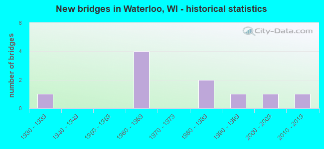
- New bridges - historical statistics
- 11930-1939
- 41960-1969
- 21980-1989
- 11990-1999
- 12000-2009
- 12010-2019

- Reconstructed bridges - Historical Statistics
- 12000-2009
- 12010-2019


- Bridge Condition - Deck
- 71.4%Good
- 14.3%Satisfactory
- 14.3%Fair

- Bridge Condition - Superstructure
- 28.6%Very good
- 42.9%Good
- 28.6%Satisfactory

- Bridge Condition - Substructure
- 28.6%Very good
- 42.9%Good
- 28.6%Satisfactory

- Bridge Condition - Channel
- 80.0%Very good
- 20.0%Good
Find on map >> Show street view
Structure Number: B280034, Location: 2.1M N JCT CTH B (Lat: 43.110547, Lng: -89.008300), Route carried "on" structure: County highway , Year Built: 1964, Year Reconstructed: 2009, Status: Open, Structure Length: 6.56m (21.52ft), Average Daily Traffic: 610 (year 2019), Average Future Daily Traffic: 730 (year 2041), Design Load: H 15, Features Intersected: IH 94, Facility Carried by Structure: CTH O
Minimum Vertical Clearance: 30+ m (98+ ft), Kilometerpoint: 0.000, Lanes on structure: 2, Lanes under structure: 4, Owner: State Highway Agency, Approaching Roadway Width: 9.1m (29.9ft), Skew: 1 degrees, Material/Design: Prestressed concrete, Design/Construction: Stringer/Multi-beam, Number Of Spans In Main Unit: 4, Length of Maximum Span: 21.0m (68.9ft), Curb-To-Curb Width: 7.3m (24.0ft), Out-to-Out Width: 8.7m (28.5ft)
Condition: Deck: Fair, Superstructure: Satisfactory, Substructure: Satisfactory, Operating Rating: 45.7 metric tons, Method Used To Determine Operating Rating: Load Factor (LF), Inventory Rating: 16.2 metric tons, Method Used To Determine Inventory Rating: Load Factor (LF), Structural Evaluation: Meets minimum limits, Deck Geometry: Meets minimum limits, Underclear: Somewhat better than minimum adequacy, Approach Roadway Alignment: Equal to present desirable criteria, Designated Inspection Frequency: Every 24 months, Inspection Date: Febuary 2022, Deck Structure Type: Concrete Cast-file-Place, Wearing Surface/Protective System: Wearing Surface: Low Slump Concrete
Find on map >> Show street view
Structure Number: B280035, Location: 1.7M N JCT CTH B (Lat: 43.110675, Lng: -88.981686), Route carried "on" structure: City street , Year Built: 1964, Year Reconstructed: 2010, Status: Open, Structure Length: 8.24m (27.03ft), Average Daily Traffic: 110 (year 2018), Average Future Daily Traffic: 110 (year 2038), Design Load: H 15, Features Intersected: IH 94, Facility Carried by Structure: LRD AIRPORT RD
Minimum Vertical Clearance: 30+ m (98+ ft), Kilometerpoint: 0.000, Lanes on structure: 2, Lanes under structure: 4, Owner: State Highway Agency, Approaching Roadway Width: 9.8m (32.2ft), Skew: 4 degrees, Material/Design: Steel, Design/Construction: Stringer/Multi-beam, Number Of Spans In Main Unit: 4, Length of Maximum Span: 27.6m (90.6ft), Curb-To-Curb Width: 7.3m (24.0ft), Out-to-Out Width: 8.5m (27.9ft)
Condition: Deck: Satisfactory, Superstructure: Satisfactory, Substructure: Satisfactory, Operating Rating: 42.5 metric tons, Method Used To Determine Operating Rating: Load Factor (LF), Inventory Rating: 24.3 metric tons, Method Used To Determine Inventory Rating: Load Factor (LF), Structural Evaluation: Equal to present minimum criteria, Deck Geometry: Somewhat better than minimum adequacy, Underclear: Somewhat better than minimum adequacy, Approach Roadway Alignment: Equal to present minimum criteria, Designated Inspection Frequency: Every 24 months, Inspection Date: June 2021, Deck Structure Type: Concrete Cast-file-Place, Wearing Surface/Protective System: Wearing Surface: Epoxy Overlay
Find on map >> Show street view
Structure Number: B280072, Location: 3.4M E JCT STH 73 TO N (Lat: 43.180703, Lng: -89.002869), Route carried "on" structure: State highway 19, Year Built: 1989, Status: Open, Structure Length: 3.30m (10.83ft), Average Daily Traffic: 5,500 (year 2019), Truck Traffic: 5%, Average Future Daily Traffic: 9,280 (year 2039), Design Load: HS 20, Features Intersected: MAUNESHA RIVER
Minimum Vertical Clearance: 30+ m (98+ ft), Kilometerpoint: 0.000, Lanes on structure: 2, Owner: State Highway Agency, Approaching Roadway Width: 11.0m (36.1ft), Skew: 5 degrees, Material/Design: Steel continuous, Design/Construction: Stringer/Multi-beam, Number Of Spans In Main Unit: 3, Length of Maximum Span: 11.6m (38.1ft), Curb or Sidewalk Widths: Left: 2.0m (6.6ft), Right: 0.0m, Curb-To-Curb Width: 11.0m (36.1ft), Out-to-Out Width: 13.1m (43.0ft)
Condition: Deck: Good, Superstructure: Good, Substructure: Good, Channel: Good, Operating Rating: 71.8 metric tons, Method Used To Determine Operating Rating: Load Factor (LF), Inventory Rating: 42.1 metric tons, Method Used To Determine Inventory Rating: Load Factor (LF), Structural Evaluation: Better than present minimum criteria, Deck Geometry: Meets minimum limits, Waterway Adequacy: Better than present minimum criteria, Approach Roadway Alignment: Equal to present desirable criteria, Designated Inspection Frequency: Every 48 months, Inspection Date: May 2020, Deck Structure Type: Concrete Cast-file-Place, Wearing Surface/Protective System: Wearing Surface: Monolithic Concrete, Deck Protection: Epoxy Coated Reinforcing
Find on map >> Show street view
Structure Number: B280073, Location: 0.3M N JCT STH 89 (Lat: 43.189500, Lng: -88.982861), Route carried "on" structure: City street , Year Built: 1989, Status: Open, Structure Length: 2.44m (8.01ft), Average Daily Traffic: 170 (year 2019), Average Future Daily Traffic: 187 (year 2039), Design Load: HS 20, Features Intersected: MAUNESHA RIVER, Facility Carried by Structure: LRD N HENDRICKS ST
Minimum Vertical Clearance: 30+ m (98+ ft), Kilometerpoint: 0.000, Lanes on structure: 2, Owner: City or Municipal Highway Agency, Approaching Roadway Width: 11.0m (36.1ft), Skew: 2 degrees, Material/Design: Prestressed concrete, Design/Construction: Stringer/Multi-beam, Number Of Spans In Main Unit: 1, Length of Maximum Span: 23.6m (77.4ft), Curb-To-Curb Width: 9.1m (29.9ft), Out-to-Out Width: 9.7m (31.8ft)
Condition: Deck: Good, Superstructure: Good, Substructure: Very good, Channel: Very good, Operating Rating: 73.0 metric tons, Method Used To Determine Operating Rating: Load Factor (LF), Inventory Rating: 37.3 metric tons, Method Used To Determine Inventory Rating: Load Factor (LF), Structural Evaluation: Better than present minimum criteria, Deck Geometry: Equal to present minimum criteria, Waterway Adequacy: Equal to present desirable criteria, Approach Roadway Alignment: Equal to present desirable criteria, Designated Inspection Frequency: Every 48 months, Inspection Date: July 2020, Deck Structure Type: Concrete Cast-file-Place, Wearing Surface/Protective System: Wearing Surface: Monolithic Concrete, Deck Protection: Epoxy Coated Reinforcing
Find on map >> Show street view
Structure Number: B280077, Location: 0.1M E JCT STH 89 TO N (Lat: 43.183781, Lng: -88.989456), Route carried "on" structure: State highway 19, Year Built: 1993, Status: Open, Structure Length: 1.49m (4.89ft), Average Daily Traffic: 7,300 (year 2019), Truck Traffic: 5%, Average Future Daily Traffic: 16,940 (year 2040), Design Load: HS 20, Features Intersected: MAUNESHA RIVER
Minimum Vertical Clearance: 30+ m (98+ ft), Kilometerpoint: 0.000, Lanes on structure: 2, Owner: State Highway Agency, Approaching Roadway Width: 18.0m (59.1ft), Material/Design: Prestressed concrete, Design/Construction: Stringer/Multi-beam, Number Of Spans In Main Unit: 1, Length of Maximum Span: 14.3m (46.9ft), Curb or Sidewalk Widths: Left: 2.0m (6.6ft), Right: 2.0m (6.6ft), Curb-To-Curb Width: 13.7m (44.9ft), Out-to-Out Width: 18.1m (59.4ft)
Condition: Deck: Good, Superstructure: Very good, Substructure: Good, Channel: Very good, Operating Rating: 52.3 metric tons, Method Used To Determine Operating Rating: Load Factor (LF), Inventory Rating: 37.3 metric tons, Method Used To Determine Inventory Rating: Load Factor (LF), Structural Evaluation: Better than present minimum criteria, Deck Geometry: Superior to present desirable criteria, Waterway Adequacy: Equal to present desirable criteria, Approach Roadway Alignment: Equal to present desirable criteria, Designated Inspection Frequency: Every 48 months, Inspection Date: July 2021, Deck Structure Type: Concrete Cast-file-Place, Wearing Surface/Protective System: Wearing Surface: Monolithic Concrete, Deck Protection: Epoxy Coated Reinforcing
Find on map >> Show street view
Structure Number: B280104, Location: 4.1M E JCT STH 73 TO N (Lat: 43.183714, Lng: -88.991714), Route carried "on" structure: State highway 19, Year Built: 2001, Status: Open, Structure Length: 1.82m (5.97ft), Average Daily Traffic: 7,700 (year 2019), Truck Traffic: 5%, Average Future Daily Traffic: 9,280 (year 2039), Design Load: HS 20, Features Intersected: MAUNESHA RIVER
Minimum Vertical Clearance: 30+ m (98+ ft), Kilometerpoint: 0.000, Lanes on structure: 2, Owner: State Highway Agency, Approaching Roadway Width: 15.2m (49.9ft), Material/Design: Prestressed concrete, Design/Construction: Box Beam or Girders - Multiple, Number Of Spans In Main Unit: 1, Length of Maximum Span: 17.4m (57.1ft), Curb or Sidewalk Widths: Left: 2.4m (7.9ft), Right: 2.4m (7.9ft), Curb-To-Curb Width: 13.4m (44.0ft), Out-to-Out Width: 18.9m (62.0ft)
Condition: Deck: Good, Superstructure: Good, Substructure: Good, Channel: Very good, Operating Rating: 62.1 metric tons, Method Used To Determine Operating Rating: Load Factor (LF), Inventory Rating: 37.3 metric tons, Method Used To Determine Inventory Rating: Load Factor (LF), Structural Evaluation: Better than present minimum criteria, Deck Geometry: Equal to present minimum criteria, Waterway Adequacy: Equal to present desirable criteria, Approach Roadway Alignment: Equal to present desirable criteria, Designated Inspection Frequency: Every 48 months, Inspection Date: May 2020, Deck Structure Type: Concrete Cast-file-Place, Wearing Surface/Protective System: Wearing Surface: Low Slump Concrete, Deck Protection: Epoxy Coated Reinforcing
Find on map >> Show street view
Structure Number: B280175, Location: 0.3 MI W JCT STH 89 (Lat: 43.183597, Lng: -88.996450), Route carried "on" structure: State highway 19, Year Built: 2017, Status: Open, Structure Length: 2.45m (8.04ft), Average Daily Traffic: 5,165 (year 2019), Average Future Daily Traffic: 6,250 (year 2037), Design Load: HL 93, Features Intersected: MAUNESHA RIVER
Minimum Vertical Clearance: 30+ m (98+ ft), Kilometerpoint: 0.000, Lanes on structure: 2, Base Highway Network: Yes, Owner: State Highway Agency, Approaching Roadway Width: 11.3m (37.1ft), Material/Design: Prestressed concrete, Design/Construction: Stringer/Multi-beam, Number Of Spans In Main Unit: 1, Length of Maximum Span: 23.2m (76.1ft), Curb or Sidewalk Widths: Left: 2.0m (6.6ft), Right: 2.0m (6.6ft), Curb-To-Curb Width: 11.0m (36.1ft), Out-to-Out Width: 14.7m (48.2ft)
Condition: Deck: Good, Superstructure: Very good, Substructure: Very good, Channel: Very good, Operating Rating: 49.9 metric tons, Method Used To Determine Operating Rating: Load and Resistance Factor Rating (LRFR) rating reported by rating factor(RF) method using HL-93 loadings, Inventory Rating: 38.6 metric tons, Method Used To Determine Inventory Rating: Load and Resistance Factor Rating (LRFR) rating reported by rating factor(RF) method using HL-93 loadings, Structural Evaluation: Equal to present desirable criteria, Deck Geometry: Meets minimum limits, Waterway Adequacy: Equal to present desirable criteria, Approach Roadway Alignment: Equal to present desirable criteria, Designated Inspection Frequency: Every 48 months, Inspection Date: August 2021, Deck Structure Type: Concrete Cast-file-Place, Wearing Surface/Protective System: Wearing Surface: Monolithic Concrete, Deck Protection: Epoxy Coated Reinforcing
Find on map >> Show street view
Structure Number: B280034, Location: 3.9M E JCT STH 73 TO N (Lat: 43.110547, Lng: -89.008300), Route carried "under" structure: Interstate 94, Year Built: 1964, Structure Length: 0. m, Average Daily Traffic: 34,600 (year 2019), Truck Traffic: 14%, Features Intersected: IH 94, Facility Carried by Structure: CTH O
Minimum Vertical Clearance: 4.91m (16.11ft), Kilometerpoint: 0.000, Lanes on structure: 2, Lanes under structure: 4, Material/Design: Prestressed concrete, Design/Construction: Stringer/Multi-beam, Length of Maximum Span: 21.0m (68.9ft)
Find on map >> Show street view
Structure Number: B280035, Location: 5.2M E JCT STH 73 TO N (Lat: 43.110675, Lng: -88.981686), Route carried "under" structure: Interstate 94, Year Built: 1964, Structure Length: 0. m, Average Daily Traffic: 36,100 (year 2018), Truck Traffic: 14%, Features Intersected: IH 94, Facility Carried by Structure: LRD AIRPORT RD
Minimum Vertical Clearance: 4.98m (16.34ft), Kilometerpoint: 0.000, Lanes on structure: 2, Lanes under structure: 4, Material/Design: Steel, Design/Construction: Stringer/Multi-beam, Length of Maximum Span: 27.6m (90.6ft)
Find on map >> Show street view
Structure Number: B280341, Location: 3.4M E JCT STH 73 TO N (Lat: 43.180000, Lng: -89.003333), Route carried "under" structure: State highway 19, Year Built: 1938, Structure Length: 0. m, Average Daily Traffic: 6,288 (year 2019), Truck Traffic: 5%, Features Intersected: STH 19-W MADISON ST, Facility Carried by Structure: CMSTPP RR
Minimum Vertical Clearance: 4.67m (15.32ft), Kilometerpoint: 0.000, Lanes under structure: 2, Material/Design: Steel, Design/Construction: Girder and Floorbeam System, Length of Maximum Span: 30.1m (98.8ft)