Bridge Statistics for Warren, Illinois (IL)
Condition, Traffic, Stress, Structural Evaluation, Project Costs
- National Bridge Inventory (NBI) Statistics
- 12Number of bridges
- 62ft / 18.7mTotal length
- $125,000Total costs
- 3,425Total average daily traffic
- 541Total average daily truck traffic
- National Bridge Inventory (NBI) Registered Bridges for Warren
- No street view available for this location
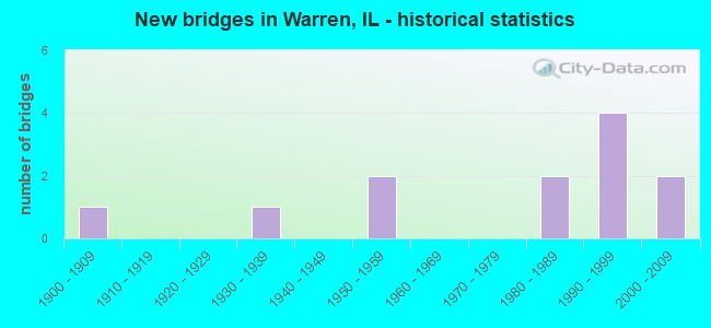
- New bridges - historical statistics
- 11900-1909
- 11930-1939
- 21950-1959
- 21980-1989
- 41990-1999
- 22000-2009

- Reconstructed bridges - Historical Statistics
- 11990-1999
- 02000-2009
- 12010-2019


- Bridge Condition - Deck
- 11.1%Excellent
- 11.1%Very good
- 33.3%Good
- 33.3%Satisfactory
- 11.1%Serious

- Bridge Condition - Superstructure
- 11.1%Excellent
- 22.2%Very good
- 33.3%Good
- 11.1%Satisfactory
- 11.1%Fair
- 11.1%Serious

- Bridge Condition - Substructure
- 11.1%Excellent
- 22.2%Very good
- 33.3%Good
- 22.2%Satisfactory
- 11.1%Fair

- Bridge Condition - Channel
- 27.3%Excellent
- 36.4%Very good
- 18.2%Good
- 18.2%Satisfactory
Find on map >> Show street view
Structure Number: 43003, Location: 3.4 MI WEST RT 78 (Lat: 42.449328, Lng: -90.046178), Route carried "on" structure: County highway , Year Built: 1935, Year Reconstructed: 1990, Status: Open, Structure Length: 5.15m (16.90ft), Average Daily Traffic: 125 (year 2021), Truck Traffic: 14%, Average Future Daily Traffic: 250 (year 2040), Design Load: HS 20, Features Intersected: CLEAR CREEK, Facility Carried by Structure: CANYON RD
Minimum Vertical Clearance: 30+ m (98+ ft), Kilometerpoint: 0.499, Lanes on structure: 2, Owner: State Highway Agency, Approaching Roadway Width: 7.2m (23.6ft), Skew: 2 degrees, Material/Design: Steel continuous, Design/Construction: Stringer/Multi-beam, Number Of Spans In Main Unit: 3, Length of Maximum Span: 17.9m (58.7ft), Curb-To-Curb Width: 9.1m (29.9ft), Out-to-Out Width: 10.1m (33.1ft)
Condition: Deck: Good, Superstructure: Good, Substructure: Satisfactory, Channel: Good, Operating Rating: 76.5 metric tons, Method Used To Determine Operating Rating: Load Factor (LF) rating reported by rating factor (RF) method using MS18 loading, Inventory Rating: 46.0 metric tons, Method Used To Determine Inventory Rating: Load Factor (LF) rating reported by rating factor (RF) method using MS18 loading, Structural Evaluation: Equal to present minimum criteria, Deck Geometry: Equal to present minimum criteria, Waterway Adequacy: Superior to present desirable criteria, Approach Roadway Alignment: Equal to present desirable criteria, Designated Inspection Frequency: Every 24 months, Other Special Inspection Frequency: Every 48 months, Inspection Date: June 2021, Other Special Inspection Date: June 2018, Deck Structure Type: Concrete Cast-file-Place, Wearing Surface/Protective System: Deck Protection: Epoxy Coated Reinforcing
Find on map >> Show street view
Structure Number: 430044, Location: 1.4 MI W OF IL 78 (Lat: 42.444647, Lng: -90.012953), Route carried "on" structure: County highway , Year Built: 1990, Status: Open, Structure Length: 1.91m (6.27ft), Average Daily Traffic: 275 (year 2021), Truck Traffic: 21%, Average Future Daily Traffic: 300 (year 2040), Design Load: HS 20, Features Intersected: WOLF CREEK, Facility Carried by Structure: CANYON ROAD
Minimum Vertical Clearance: 30+ m (98+ ft), Kilometerpoint: 3.412, Lanes on structure: 2, Owner: State Highway Agency, Approaching Roadway Width: 7.9m (25.9ft), Material/Design: Prestressed concrete, Design/Construction: Box Beam or Girders - Multiple, Number Of Spans In Main Unit: 1, Length of Maximum Span: 18.0m (59.1ft), Curb-To-Curb Width: 8.5m (27.9ft), Out-to-Out Width: 8.5m (27.9ft)
Condition: Deck: Satisfactory, Superstructure: Satisfactory, Substructure: Good, Channel: Very good, Operating Rating: 63.8 metric tons, Method Used To Determine Operating Rating: Load Factor (LF) rating reported by rating factor (RF) method using MS18 loading, Inventory Rating: 39.5 metric tons, Method Used To Determine Inventory Rating: Load Factor (LF) rating reported by rating factor (RF) method using MS18 loading, Structural Evaluation: Equal to present minimum criteria, Deck Geometry: Equal to present minimum criteria, Waterway Adequacy: Equal to present desirable criteria, Approach Roadway Alignment: Equal to present desirable criteria, Designated Inspection Frequency: Every 24 months, Inspection Date: November 2021, Deck Structure Type: Concrete Precast Panels, Wearing Surface/Protective System: Wearing Surface: Bituminous, Membrane: Built-up
Find on map >> Show street view
Structure Number: 43005, Location: 4 MI. W. OF NORA (Lat: 42.445022, Lng: -90.035214), Route carried "on" structure: County highway , Year Built: 1994, Status: Open, Structure Length: 2.96m (9.71ft), Average Daily Traffic: 125 (year 2021), Truck Traffic: 14%, Average Future Daily Traffic: 200 (year 2040), Design Load: HS 20, Features Intersected: BIRCH CREEK, Facility Carried by Structure: CANYON ROAD
Minimum Vertical Clearance: 30+ m (98+ ft), Kilometerpoint: 1.561, Lanes on structure: 2, Owner: State Highway Agency, Approaching Roadway Width: 8.4m (27.6ft), Skew: 3 degrees, Material/Design: Prestressed concrete, Design/Construction: Stringer/Multi-beam, Number Of Spans In Main Unit: 1, Length of Maximum Span: 28.7m (94.2ft), Curb-To-Curb Width: 9.5m (31.2ft), Out-to-Out Width: 10.3m (33.8ft)
Condition: Deck: Satisfactory, Superstructure: Very good, Substructure: Very good, Channel: Very good, Operating Rating: 73.9 metric tons, Method Used To Determine Operating Rating: Load Factor (LF) rating reported by rating factor (RF) method using MS18 loading, Inventory Rating: 38.9 metric tons, Method Used To Determine Inventory Rating: Load Factor (LF) rating reported by rating factor (RF) method using MS18 loading, Structural Evaluation: Equal to present desirable criteria, Deck Geometry: Equal to present minimum criteria, Waterway Adequacy: Equal to present desirable criteria, Approach Roadway Alignment: Equal to present minimum criteria, Designated Inspection Frequency: Every 48 months, Inspection Date: June 2019, Deck Structure Type: Concrete Cast-file-Place, Wearing Surface/Protective System: Deck Protection: Epoxy Coated Reinforcing
Find on map >> Show street view
Structure Number: 433005, Location: 1 MILE WEST WARREN (Lat: 42.495792, Lng: -90.027061), Route carried "on" structure: County highway , Year Built: 1953, Status: Temporarily open, Structure Length: 1.16m (3.81ft), Average Daily Traffic: 850 (year 2021), Truck Traffic: 7%, Average Future Daily Traffic: 1,300 (year 2040), Design Load: H 15, Features Intersected: CLEAR CREEK, Facility Carried by Structure: EAST STAGECOACH RO
Minimum Vertical Clearance: 30+ m (98+ ft), Kilometerpoint: 39.315, Lanes on structure: 2, Owner: County Highway Agency, Approaching Roadway Width: 9.8m (32.2ft), Material/Design: Steel, Design/Construction: Stringer/Multi-beam, Number Of Spans In Main Unit: 1, Length of Maximum Span: 11.3m (37.1ft), Curb-To-Curb Width: 7.3m (24.0ft), Out-to-Out Width: 8.0m (26.2ft)
Condition: Deck: Serious, Superstructure: Serious, Substructure: Fair, Channel: Excellent, Structural Evaluation: High priority of corrective action, Deck Geometry: Meets minimum limits, Waterway Adequacy: Better than present minimum criteria, Approach Roadway Alignment: Equal to present desirable criteria, Length Of Structure Improvement: 1.16m (3.81ft), Designated Inspection Frequency: Every 24 months, Inspection Date: June 2020, Bridge Improvement Cost: $48,000, Roadway Improvement Cost: $5,000, Total Project Cost: $72,000, Deck Structure Type: Concrete Cast-file-Place
Find on map >> Show street view
Structure Number: 433026, Location: SW CORNER OF WARREN (Lat: 42.484756, Lng: -90.002278), Route carried "on" structure: County highway , Year Built: 1956, Year Reconstructed: 2017, Status: Open, Structure Length: 0.95m (3.12ft), Average Daily Traffic: 250 (year 2021), Truck Traffic: 33%, Average Future Daily Traffic: 350 (year 2040), Design Load: HS 25 or greater, Features Intersected: Wolf Creek, Facility Carried by Structure: CH-10 (N Fiedler R
Minimum Vertical Clearance: 30+ m (98+ ft), Kilometerpoint: 1.239, Lanes on structure: 2, Owner: County Highway Agency, Approaching Roadway Width: 7.9m (25.9ft), Skew: 4 degrees, Material/Design: Steel, Design/Construction: Stringer/Multi-beam, Number Of Spans In Main Unit: 1, Length of Maximum Span: 9.2m (30.2ft), Curb-To-Curb Width: 7.9m (25.9ft), Out-to-Out Width: 7.9m (25.9ft)
Condition: Deck: Excellent, Superstructure: Excellent, Substructure: Excellent, Channel: Excellent, Operating Rating: 51.2 metric tons, Method Used To Determine Operating Rating: Load and Resistance Factor Rating (LRFR) rating reported by rating factor(RF) method using HL-93 loadings, Inventory Rating: 39.5 metric tons, Method Used To Determine Inventory Rating: Load and Resistance Factor Rating (LRFR) rating reported by rating factor(RF) method using HL-93 loadings, Structural Evaluation: Superior to present desirable criteria, Deck Geometry: Somewhat better than minimum adequacy, Waterway Adequacy: Equal to present desirable criteria, Approach Roadway Alignment: Equal to present minimum criteria, Designated Inspection Frequency: Every 48 months, Inspection Date: March 2019, Deck Structure Type: Concrete Cast-file-Place, Wearing Surface/Protective System: Membrane: Built-up, Deck Protection: Epoxy Coated Reinforcing
Find on map >> Show street view
Structure Number: 433177, Location: 2.5 MI N OF NORA (Lat: 42.501178, Lng: -89.946364), Route carried "on" structure: County highway , Year Built: 1901, Status: Open, Structure Length: 0.76m (2.49ft), Average Daily Traffic: 50 (year 2021), Average Future Daily Traffic: 50 (year 2040), Features Intersected: UNNAMED CREEK, Facility Carried by Structure: TOWNSHIP ROAD 290
Minimum Vertical Clearance: 30+ m (98+ ft), Kilometerpoint: 0.499, Lanes on structure: 1, Owner: Town or Township Highway Agency, Approaching Roadway Width: 5.5m (18.0ft), Material/Design: Steel, Design/Construction: Stringer/Multi-beam, Number Of Spans In Main Unit: 1, Length of Maximum Span: 7.0m (23.0ft), Curb-To-Curb Width: 4.8m (15.7ft), Out-to-Out Width: 4.9m (16.1ft)
Condition: Deck: Satisfactory, Superstructure: Fair, Substructure: Satisfactory, Channel: Satisfactory, Operating Rating: 33.4 metric tons, Method Used To Determine Operating Rating: Load Factor (LF) rating reported by rating factor (RF) method using MS18 loading, Inventory Rating: 20.1 metric tons, Method Used To Determine Inventory Rating: Load Factor (LF) rating reported by rating factor (RF) method using MS18 loading, Structural Evaluation: Somewhat better than minimum adequacy, Deck Geometry: Equal to present desirable criteria, Waterway Adequacy: Equal to present minimum criteria, Approach Roadway Alignment: Better than present minimum criteria, Length Of Structure Improvement: 1.37m (4.49ft), Designated Inspection Frequency: Every 24 months, Other Special Inspection Frequency: Every 12 months, Inspection Date: March 2021, Other Special Inspection Date: Febuary 2022, Bridge Improvement Cost: $35,000, Roadway Improvement Cost: $4,000, Total Project Cost: $53,000, Deck Structure Type: Wood or Timber, Wearing Surface/Protective System: Wearing Surface: Wood or Timber
Find on map >> Show street view
Structure Number: 433235, Location: 2 MI S OF WARREN (Lat: 42.459161, Lng: -90.001456), Route carried "on" structure: County highway , Year Built: 1989, Status: Open, Structure Length: 1.70m (5.58ft), Average Daily Traffic: 50 (year 2021), Truck Traffic: 4%, Average Future Daily Traffic: 50 (year 2040), Design Load: HS 20, Features Intersected: WOLF CREEK, Facility Carried by Structure: MAHONEY ROAD
Minimum Vertical Clearance: 30+ m (98+ ft), Kilometerpoint: 1.159, Lanes on structure: 2, Owner: Town or Township Highway Agency, Approaching Roadway Width: 7.3m (24.0ft), Material/Design: Concrete, Design/Construction: Channel Beam, Number Of Spans In Main Unit: 3, Length of Maximum Span: 5.5m (18.0ft), Curb-To-Curb Width: 8.0m (26.2ft), Out-to-Out Width: 8.0m (26.2ft)
Condition: Deck: Good, Superstructure: Good, Substructure: Good, Channel: Good, Operating Rating: 44.4 metric tons, Method Used To Determine Operating Rating: Assigned rating based on Load Factor Design (LFD) reported by rating factor (RF) using MS18 loading, Inventory Rating: 32.4 metric tons, Method Used To Determine Inventory Rating: Assigned rating based on Load Factor Design (LFD) reported by rating factor (RF) using MS18 loading, Structural Evaluation: Better than present minimum criteria, Deck Geometry: Equal to present minimum criteria, Waterway Adequacy: Better than present minimum criteria, Approach Roadway Alignment: Better than present minimum criteria, Designated Inspection Frequency: Every 48 months, Inspection Date: March 2019, Deck Structure Type: Concrete Precast Panels
Find on map >> Show street view
Structure Number: 433236, Location: 2 MI E OF WARREN (Lat: 42.505642, Lng: -89.954653), Route carried "on" structure: County highway , Year Built: 1986, Status: Open, Structure Length: 0.70m (2.30ft), Average Daily Traffic: 50 (year 2021), Truck Traffic: 6%, Average Future Daily Traffic: 100 (year 2040), Design Load: HS 20, Features Intersected: BR OF SPAFFORD CR, Facility Carried by Structure: TR 17A
Minimum Vertical Clearance: 30+ m (98+ ft), Kilometerpoint: 2.494, Lanes on structure: 2, Owner: Town or Township Highway Agency, Approaching Roadway Width: 7.3m (24.0ft), Material/Design: Concrete, Design/Construction: Slab, Number Of Spans In Main Unit: 1, Length of Maximum Span: 6.4m (21.0ft), Curb-To-Curb Width: 7.3m (24.0ft), Out-to-Out Width: 7.9m (25.9ft)
Condition: Deck: Good, Superstructure: Good, Substructure: Good, Channel: Satisfactory, Operating Rating: 44.4 metric tons, Method Used To Determine Operating Rating: Assigned rating based on Load Factor Design (LFD) reported by rating factor (RF) using MS18 loading, Inventory Rating: 32.4 metric tons, Method Used To Determine Inventory Rating: Assigned rating based on Load Factor Design (LFD) reported by rating factor (RF) using MS18 loading, Structural Evaluation: Better than present minimum criteria, Deck Geometry: Equal to present minimum criteria, Waterway Adequacy: Better than present minimum criteria, Approach Roadway Alignment: Better than present minimum criteria, Designated Inspection Frequency: Every 48 months, Inspection Date: March 2019, Deck Structure Type: Concrete Cast-file-Place
Find on map >> Show street view
Structure Number: 433259, Location: .25 MI. W. OF IL78 (Lat: 42.474350, Lng: -89.991897), Route carried "on" structure: County highway , Year Built: 1999, Status: Open, Structure Length: 1.87m (6.14ft), Average Daily Traffic: 50 (year 2021), Average Future Daily Traffic: 50 (year 2040), Design Load: HS 20, Features Intersected: WOLF CREEK, Facility Carried by Structure: HICKS ROAD
Minimum Vertical Clearance: 30+ m (98+ ft), Kilometerpoint: 1.352, Lanes on structure: 2, Owner: Town or Township Highway Agency, Approaching Roadway Width: 5.5m (18.0ft), Material/Design: Prestressed concrete, Design/Construction: Box Beam or Girders - Multiple, Number Of Spans In Main Unit: 1, Length of Maximum Span: 18.0m (59.1ft), Curb-To-Curb Width: 7.3m (24.0ft), Out-to-Out Width: 7.3m (24.0ft)
Condition: Deck: Very good, Superstructure: Very good, Substructure: Very good, Channel: Excellent, Operating Rating: 44.1 metric tons, Method Used To Determine Operating Rating: Assigned rating based on Load Factor Design (LFD) reported by rating factor (RF) using MS18 loading, Inventory Rating: 32.4 metric tons, Method Used To Determine Inventory Rating: Assigned rating based on Load Factor Design (LFD) reported by rating factor (RF) using MS18 loading, Structural Evaluation: Equal to present desirable criteria, Deck Geometry: Equal to present minimum criteria, Waterway Adequacy: Superior to present desirable criteria, Approach Roadway Alignment: Equal to present desirable criteria, Designated Inspection Frequency: Every 48 months, Inspection Date: March 2019, Deck Structure Type: Concrete Precast Panels
Find on map >> Show street view
Structure Number: 433272, Location: 1.5MI SW WARREN (Lat: 42.481106, Lng: -90.034733), Route carried "on" structure: County highway , Year Built: 2008, Status: Open, Structure Length: 0.72m (2.36ft), Average Daily Traffic: 75 (year 2021), Average Future Daily Traffic: 76 (year 2032), Design Load: HS 20, Features Intersected: CLEAR CREEK, Facility Carried by Structure: E. TWIN BRIDGES RD
Minimum Vertical Clearance: 30+ m (98+ ft), Kilometerpoint: 4.506, Lanes on structure: 2, Owner: Town or Township Highway Agency, Approaching Roadway Width: 6.1m (20.0ft), Material/Design: Concrete, Design/Construction: Culvert, Number Of Spans In Main Unit: 2, Length of Maximum Span: 3.4m (11.2ft)
Condition: Channel: Very good, Culverts: Very good, Operating Rating: 44.1 metric tons, Method Used To Determine Operating Rating: Assigned rating based on Load Factor Design (LFD) reported by rating factor (RF) using MS18 loading, Inventory Rating: 32.4 metric tons, Method Used To Determine Inventory Rating: Assigned rating based on Load Factor Design (LFD) reported by rating factor (RF) using MS18 loading, Structural Evaluation: Equal to present desirable criteria, Waterway Adequacy: Superior to present desirable criteria, Approach Roadway Alignment: Superior to present desirable criteria, Designated Inspection Frequency: Every 48 months, Inspection Date: March 2019
Find on map >> Show street view
Structure Number: 433273, Location: 1.5 M SW WARREN (Lat: 42.481097, Lng: -90.035911), Route carried "on" structure: County highway , Year Built: 2008, Status: Open, Structure Length: 0.84m (2.76ft), Average Daily Traffic: 75 (year 2021), Average Future Daily Traffic: 76 (year 2032), Design Load: HS 20, Features Intersected: CLEAR CREEK, Facility Carried by Structure: E TWIN BRIDGES ROA
Minimum Vertical Clearance: 30+ m (98+ ft), Kilometerpoint: 4.409, Lanes on structure: 2, Owner: Town or Township Highway Agency, Approaching Roadway Width: 6.1m (20.0ft), Material/Design: Concrete, Design/Construction: Culvert, Number Of Spans In Main Unit: 2, Length of Maximum Span: 4.0m (13.1ft)
Condition: Channel: Very good, Culverts: Very good, Operating Rating: 44.1 metric tons, Method Used To Determine Operating Rating: Assigned rating based on Load Factor Design (LFD) reported by rating factor (RF) using MS18 loading, Inventory Rating: 32.4 metric tons, Method Used To Determine Inventory Rating: Assigned rating based on Load Factor Design (LFD) reported by rating factor (RF) using MS18 loading, Structural Evaluation: Equal to present desirable criteria, Waterway Adequacy: Superior to present desirable criteria, Approach Roadway Alignment: Superior to present desirable criteria, Designated Inspection Frequency: Every 48 months, Inspection Date: March 2019
Find on map >> Show street view
Structure Number: 439914, Location: .1 MI S WISC ST LN (Lat: 42.506575, Lng: -90.016747), Route carried "under" structure: State highway 78, Year Built: 1995, Structure Length: 0. m, Average Daily Traffic: 1,450 (year 2021), Truck Traffic: 21%, Features Intersected: IL 78, Facility Carried by Structure: CN RR
Minimum Vertical Clearance: 4.72m (15.49ft), Kilometerpoint: 344.567, Lanes under structure: 2, Material/Design: Steel, Length of Maximum Span: 45.7m (149.9ft)