Bridge Statistics for Warren AFB, Wyoming (WY)
Condition, Traffic, Stress, Structural Evaluation, Project Costs
- National Bridge Inventory (NBI) Statistics
- 12Number of bridges
- 85ft / 26.0mTotal length
- $2,310,000Total costs
- 42,464Total average daily traffic
- 14,103Total average daily truck traffic
- National Bridge Inventory (NBI) Registered Bridges for Warren AFB
- No street view available for this location
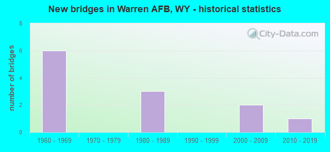
- New bridges - historical statistics
- 61960-1969
- 31980-1989
- 22000-2009
- 12010-2019


- Bridge Condition - Deck
- 14.3%Good
- 42.9%Satisfactory
- 28.6%Fair
- 14.3%Poor

- Bridge Condition - Superstructure
- 14.3%Very good
- 14.3%Good
- 28.6%Satisfactory
- 42.9%Fair

- Bridge Condition - Channel
- 66.7%Good
- 16.7%Satisfactory
- 16.7%Fair

- Bridge Condition - Culverts
- 66.7%Good
- 33.3%Fair
Find on map >> Show street view
Structure Number: AFWYGHLN00505, Location: 0.15 miles north of Missi (Lat: 41.146133, Lng: -104.856111), Route carried "on" structure: Other road , Year Built: 1983, Year Reconstructed: 1995, Status: Open, Structure Length: 0.77m (2.53ft), Average Daily Traffic: 1,870 (year 2013), Average Future Daily Traffic: 2,000 (year 2033), Design Load: HS 20, Features Intersected: CROW CREEK, Facility Carried by Structure: OLD GLORY ROAD
Minimum Vertical Clearance: 30+ m (98+ ft), Kilometerpoint: 0.000, Lanes on structure: 4, Owner: Air Force, Approaching Roadway Width: 15.9m (52.2ft), Skew: 3 degrees, Material/Design: Concrete, Design/Construction: Culvert, Number Of Spans In Main Unit: 2, Length of Maximum Span: 3.9m (12.8ft), Curb or Sidewalk Widths: Left: 0.0m, Right: 1.4m (4.6ft)
Condition: Channel: Fair, Culverts: Fair, Operating Rating: 74.4 metric tons, Method Used To Determine Operating Rating: Load Factor (LF), Inventory Rating: 44.4 metric tons, Method Used To Determine Inventory Rating: Load Factor (LF), Structural Evaluation: Somewhat better than minimum adequacy, Waterway Adequacy: Equal to present desirable criteria, Approach Roadway Alignment: Equal to present desirable criteria, Designated Inspection Frequency: Every 24 months, Inspection Date: September 2020
Find on map >> Show street view
Structure Number: AFWYGHLN0052, Location: 0.17 miles west of Gate 2 (Lat: 41.141972, Lng: -104.851156), Route carried "on" structure: Other road , Year Built: 2015, Status: Open, Structure Length: 5.11m (16.77ft), Average Daily Traffic: 5 (year 2016), Average Future Daily Traffic: 6 (year 2036), Design Load: HL 93, Features Intersected: CROW CREEK, Facility Carried by Structure: MISSILE DRIVE
Minimum Vertical Clearance: 30+ m (98+ ft), Kilometerpoint: 0.000, Lanes on structure: 2, Owner: Air Force, Approaching Roadway Width: 9.8m (32.2ft), Material/Design: Prestressed concrete, Design/Construction: Slab, Number Of Spans In Main Unit: 3, Length of Maximum Span: 16.8m (55.1ft), Curb-To-Curb Width: 11.0m (36.1ft), Out-to-Out Width: 12.1m (39.7ft)
Condition: Deck: Satisfactory, Superstructure: Very good, Substructure: Satisfactory, Channel: Good, Operating Rating: 44.0 metric tons, Method Used To Determine Operating Rating: Load and Resistance Factor (LRFR), Inventory Rating: 26.3 metric tons, Method Used To Determine Inventory Rating: Load and Resistance Factor (LRFR), Structural Evaluation: Equal to present minimum criteria, Deck Geometry: Superior to present desirable criteria, Waterway Adequacy: Equal to present desirable criteria, Approach Roadway Alignment: Equal to present desirable criteria, Designated Inspection Frequency: Every 24 months, Inspection Date: September 2020, Bridge Improvement Cost: $40,000, Roadway Improvement Cost: $4,000, Total Project Cost: $60,000, Deck Structure Type: Concrete Cast-file-Place
Find on map >> Show street view
Structure Number: AFWYGHLN0067, Location: 0.10 miles north of Missi (Lat: 41.148769, Lng: -104.865939), Route carried "on" structure: Other road , Year Built: 1985, Status: Open, Structure Length: 4.18m (13.71ft), Average Daily Traffic: 410 (year 2013), Average Future Daily Traffic: 492 (year 2033), Design Load: HS 20, Features Intersected: CROW CREEK, Facility Carried by Structure: S FRONTIER ROAD
Minimum Vertical Clearance: 30+ m (98+ ft), Kilometerpoint: 0.000, Lanes on structure: 2, Owner: Air Force, Approaching Roadway Width: 8.5m (27.9ft), Skew: 3 degrees, Material/Design: Prestressed concrete, Design/Construction: Stringer/Multi-beam, Number Of Spans In Main Unit: 1, Length of Maximum Span: 40.8m (133.9ft), Curb-To-Curb Width: 11.6m (38.1ft), Out-to-Out Width: 12.5m (41.0ft)
Condition: Deck: Poor, Superstructure: Fair, Substructure: Satisfactory, Channel: Good, Operating Rating: 85.3 metric tons, Method Used To Determine Operating Rating: Load Factor (LF), Inventory Rating: 29.9 metric tons, Method Used To Determine Inventory Rating: Load Factor (LF), Structural Evaluation: Somewhat better than minimum adequacy, Deck Geometry: Better than present minimum criteria, Waterway Adequacy: Equal to present desirable criteria, Approach Roadway Alignment: Equal to present desirable criteria, Designated Inspection Frequency: Every 24 months, Inspection Date: September 2020, Bridge Improvement Cost: $1,500,000, Roadway Improvement Cost: $150,000, Total Project Cost: $2,250,000, Deck Structure Type: Concrete Cast-file-Place, Wearing Surface/Protective System: Wearing Surface: Monolithic Concrete, Deck Protection: Epoxy Coated Reinforcing
Find on map >> Show street view
Structure Number: AFWYGHLN01431, Location: 0.30 miles south of Randa (Lat: 41.158728, Lng: -104.879433), Route carried "on" structure: Other road , Year Built: 1987, Status: Open, Structure Length: 3.40m (11.15ft), Average Daily Traffic: 700 (year 2013), Average Future Daily Traffic: 840 (year 2033), Features Intersected: CROW CREEK, Facility Carried by Structure: MISSILE DRIVE WEST
Minimum Vertical Clearance: 30+ m (98+ ft), Kilometerpoint: 0.000, Lanes on structure: 2, Owner: Air Force, Approaching Roadway Width: 12.2m (40.0ft), Skew: 3 degrees, Material/Design: Prestressed concrete, Design/Construction: Stringer/Multi-beam, Number Of Spans In Main Unit: 1, Length of Maximum Span: 33.1m (108.6ft), Curb-To-Curb Width: 12.3m (40.4ft), Out-to-Out Width: 13.2m (43.3ft)
Condition: Deck: Good, Superstructure: Good, Substructure: Satisfactory, Channel: Good, Operating Rating: 57.1 metric tons, Method Used To Determine Operating Rating: Load Factor (LF), Inventory Rating: 33.6 metric tons, Method Used To Determine Inventory Rating: Load Factor (LF), Structural Evaluation: Equal to present minimum criteria, Deck Geometry: Superior to present desirable criteria, Waterway Adequacy: Equal to present desirable criteria, Approach Roadway Alignment: Equal to present desirable criteria, Designated Inspection Frequency: Every 24 months, Inspection Date: September 2020, Deck Structure Type: Concrete Cast-file-Place, Wearing Surface/Protective System: Wearing Surface: Bituminous, Deck Protection: Epoxy Coated Reinforcing
Find on map >> Show street view
Structure Number: AFWYGHLN02116, Location: At southeast corner of th (Lat: 41.155114, Lng: -104.853194), Route carried "on" structure: Other road , Year Built: 2002, Status: Open, Structure Length: 0.90m (2.95ft), Average Future Daily Traffic: 2 (year 2036), Design Load: HS 20, Features Intersected: AFWYGHLN02116, Facility Carried by Structure: GOLF COURSE ROAD
Minimum Vertical Clearance: 30+ m (98+ ft), Kilometerpoint: 0.000, Lanes on structure: 2, Owner: Air Force, Approaching Roadway Width: 4.9m (16.1ft), Skew: 3 degrees, Material/Design: Concrete, Design/Construction: Culvert, Number Of Spans In Main Unit: 3, Length of Maximum Span: 2.7m (8.9ft)
Condition: Channel: Good, Culverts: Good, Operating Rating: 39.9 metric tons, Method Used To Determine Operating Rating: Load Factor (LF), Inventory Rating: 23.6 metric tons, Method Used To Determine Inventory Rating: Load Factor (LF), Structural Evaluation: Equal to present minimum criteria, Waterway Adequacy: Equal to present desirable criteria, Approach Roadway Alignment: Equal to present desirable criteria, Designated Inspection Frequency: Every 24 months, Inspection Date: September 2020
Find on map >> Show street view
Structure Number: AYP, Location: Laramie - Cheyenne (Lat: 41.112828, Lng: -104.933361), Route carried "on" structure: Interstate 80, Year Built: 1961, Status: Open, Structure Length: 2.14m (7.02ft), Average Daily Traffic: 6,886 (year 2021), Truck Traffic: 50%, Average Future Daily Traffic: 9,640 (year 2041), Design Load: HS 20+Mod, Features Intersected: Machinery Pass
Minimum Vertical Clearance: 30+ m (98+ ft), Kilometerpoint: 571.304, Lanes on structure: 2, Base Highway Network: Yes (Inventory Route: ML8, Subroute: 3), Owner: State Highway Agency, Approaching Roadway Width: 11.6m (38.1ft), Skew: 10 degrees, Material/Design: Concrete continuous, Design/Construction: Slab, Number Of Spans In Main Unit: 3, Length of Maximum Span: 8.0m (26.2ft), Curb-To-Curb Width: 11.6m (38.1ft), Out-to-Out Width: 12.5m (41.0ft)
Condition: Deck: Fair, Superstructure: Fair, Substructure: Satisfactory, Operating Rating: 46.1 metric tons, Method Used To Determine Operating Rating: Load Factor (LF), Inventory Rating: 27.4 metric tons, Method Used To Determine Inventory Rating: Load Factor (LF), Structural Evaluation: Somewhat better than minimum adequacy, Deck Geometry: Equal to present minimum criteria, Approach Roadway Alignment: Equal to present desirable criteria, Designated Inspection Frequency: Every 24 months, Inspection Date: March 2020, Deck Structure Type: Concrete Cast-file-Place, Wearing Surface/Protective System: Wearing Surface: Bituminous, Membrane: Preformed Fabric
Find on map >> Show street view
Structure Number: AYQ, Location: Laramie - Cheyenne (Lat: 41.113242, Lng: -104.933433), Route carried "on" structure: Interstate 80, Year Built: 1961, Status: Open, Structure Length: 2.14m (7.02ft), Average Daily Traffic: 6,902 (year 2021), Truck Traffic: 44%, Average Future Daily Traffic: 9,663 (year 2041), Design Load: HS 20+Mod, Features Intersected: Machinery Pass
Minimum Vertical Clearance: 30+ m (98+ ft), Kilometerpoint: 571.019, Lanes on structure: 2, Base Highway Network: Yes (Inventory Route: ML8, Subroute: 3), Owner: State Highway Agency, Approaching Roadway Width: 11.6m (38.1ft), Skew: 10 degrees, Material/Design: Concrete continuous, Design/Construction: Slab, Number Of Spans In Main Unit: 3, Length of Maximum Span: 8.0m (26.2ft), Curb-To-Curb Width: 11.6m (38.1ft), Out-to-Out Width: 12.5m (41.0ft)
Condition: Deck: Fair, Superstructure: Fair, Substructure: Satisfactory, Operating Rating: 46.1 metric tons, Method Used To Determine Operating Rating: Load Factor (LF), Inventory Rating: 27.4 metric tons, Method Used To Determine Inventory Rating: Load Factor (LF), Structural Evaluation: Somewhat better than minimum adequacy, Deck Geometry: Equal to present minimum criteria, Approach Roadway Alignment: Equal to present desirable criteria, Designated Inspection Frequency: Every 24 months, Inspection Date: March 2020, Deck Structure Type: Concrete Cast-file-Place, Wearing Surface/Protective System: Wearing Surface: Bituminous, Membrane: Preformed Fabric
Find on map >> Show street view
Structure Number: AYR, Location: Laramie - Cheyenne (Lat: 41.116506, Lng: -104.886675), Route carried "on" structure: Interstate 80, Year Built: 1961, Status: Open, Structure Length: 3.35m (10.99ft), Average Daily Traffic: 7,971 (year 2021), Truck Traffic: 44%, Average Future Daily Traffic: 11,159 (year 2041), Design Load: HS 20+Mod, Features Intersected: WYO 222
Minimum Vertical Clearance: 30+ m (98+ ft), Kilometerpoint: 575.263, Lanes on structure: 2, Lanes under structure: 3, Base Highway Network: Yes (Inventory Route: ML8, Subroute: 3), Owner: State Highway Agency, Approaching Roadway Width: 11.6m (38.1ft), Skew: 10 degrees, Material/Design: Concrete continuous, Design/Construction: Slab, Number Of Spans In Main Unit: 3, Length of Maximum Span: 13.4m (44.0ft), Curb-To-Curb Width: 11.6m (38.1ft), Out-to-Out Width: 12.2m (40.0ft)
Condition: Deck: Satisfactory, Superstructure: Satisfactory, Substructure: Satisfactory, Operating Rating: 60.8 metric tons, Method Used To Determine Operating Rating: Load Factor (LF), Inventory Rating: 36.3 metric tons, Method Used To Determine Inventory Rating: Load Factor (LF), Structural Evaluation: Equal to present minimum criteria, Deck Geometry: Equal to present minimum criteria, Underclear: High priority of corrective action, Approach Roadway Alignment: Equal to present desirable criteria, Designated Inspection Frequency: Every 24 months, Inspection Date: March 2020, Deck Structure Type: Concrete Cast-file-Place
Find on map >> Show street view
Structure Number: AYS, Location: Laramie - Cheyenne (Lat: 41.116925, Lng: -104.886672), Route carried "on" structure: Interstate 80, Year Built: 1961, Status: Open, Structure Length: 3.35m (10.99ft), Average Daily Traffic: 7,311 (year 2021), Truck Traffic: 44%, Average Future Daily Traffic: 10,235 (year 2041), Design Load: HS 20+Mod, Features Intersected: WYO 222
Minimum Vertical Clearance: 30+ m (98+ ft), Kilometerpoint: 574.986, Lanes on structure: 2, Lanes under structure: 3, Base Highway Network: Yes (Inventory Route: ML8, Subroute: 3), Owner: State Highway Agency, Approaching Roadway Width: 11.6m (38.1ft), Skew: 10 degrees, Material/Design: Concrete continuous, Design/Construction: Slab, Number Of Spans In Main Unit: 3, Length of Maximum Span: 13.4m (44.0ft), Curb-To-Curb Width: 11.6m (38.1ft), Out-to-Out Width: 12.2m (40.0ft)
Condition: Deck: Satisfactory, Superstructure: Satisfactory, Substructure: Satisfactory, Operating Rating: 60.8 metric tons, Method Used To Determine Operating Rating: Load Factor (LF), Inventory Rating: 36.3 metric tons, Method Used To Determine Inventory Rating: Load Factor (LF), Structural Evaluation: Equal to present minimum criteria, Deck Geometry: Equal to present minimum criteria, Underclear: High priority of corrective action, Approach Roadway Alignment: Equal to present desirable criteria, Designated Inspection Frequency: Every 24 months, Inspection Date: March 2020, Deck Structure Type: Concrete Cast-file-Place
Find on map >> Show street view
Structure Number: LMQ, Location: Happy Jack Road (Lat: 41.130036, Lng: -104.912336), Route carried "on" structure: Alternate State highway 107, Year Built: 2004, Status: Open, Structure Length: 0.67m (2.20ft), Average Daily Traffic: 2,329 (year 2021), Truck Traffic: 4%, Average Future Daily Traffic: 3,261 (year 2041), Design Load: HS 25 or greater, Features Intersected: Diamond Creek, Facility Carried by Structure: WYO 210
Minimum Vertical Clearance: 30+ m (98+ ft), Kilometerpoint: 6.244, Lanes on structure: 2, Owner: State Highway Agency, Approaching Roadway Width: 13.1m (43.0ft), Skew: 2 degrees, Material/Design: Concrete, Design/Construction: Culvert, Number Of Spans In Main Unit: 2, Length of Maximum Span: 3.0m (9.8ft)
Condition: Channel: Satisfactory, Culverts: Good, Operating Rating: 32.7 metric tons, Method Used To Determine Operating Rating: Field evaluation and documented engineering judgment, Inventory Rating: 32.7 metric tons, Method Used To Determine Inventory Rating: Field evaluation and documented engineering judgment, Structural Evaluation: Better than present minimum criteria, Waterway Adequacy: Equal to present desirable criteria, Approach Roadway Alignment: Equal to present desirable criteria, Designated Inspection Frequency: Every 24 months, Inspection Date: March 2020
Find on map >> Show street view
Structure Number: AYR, Location: Laramie - Cheyenne (Lat: 41.116506, Lng: -104.886675), Route carried "under" structure: State highway 222, Year Built: 1961, Structure Length: 0. m, Average Daily Traffic: 4,040 (year 2021), Truck Traffic: 10%, Features Intersected: WYO 222, Facility Carried by Structure: I-80 EBL
Minimum Vertical Clearance: 4.61m (15.12ft), Kilometerpoint: 1.242, Lanes on structure: 2, Lanes under structure: 3, Material/Design: Concrete continuous, Design/Construction: Slab, Length of Maximum Span: 13.4m (44.0ft)
Find on map >> Show street view
Structure Number: AYS, Location: Laramie - Cheyenne (Lat: 41.116925, Lng: -104.886672), Route carried "under" structure: State highway 222, Year Built: 1961, Structure Length: 0. m, Average Daily Traffic: 4,040 (year 2021), Truck Traffic: 10%, Features Intersected: WYO 222, Facility Carried by Structure: I-80 WBL
Minimum Vertical Clearance: 4.88m (16.01ft), Kilometerpoint: 1.289, Lanes on structure: 2, Lanes under structure: 3, Material/Design: Concrete continuous, Design/Construction: Slab, Length of Maximum Span: 13.4m (44.0ft)