Bridge Statistics for Walton, Kentucky (KY)
Condition, Traffic, Stress, Structural Evaluation, Project Costs
- National Bridge Inventory (NBI) Statistics
- 31Number of bridges
- 249ft / 76.4mTotal length
- $4,312,000Total costs
- 554,760Total average daily traffic
- 109,034Total average daily truck traffic
- National Bridge Inventory (NBI) Registered Bridges for Walton
- No street view available for this location
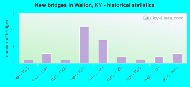
- New bridges - historical statistics
- 11930-1939
- 31940-1949
- 11950-1959
- 111960-1969
- 71970-1979
- 21980-1989
- 11990-1999
- 22000-2009
- 32010-2019


- Bridge Condition - Deck
- 6.3%Very good
- 43.8%Good
- 37.5%Satisfactory
- 12.5%Fair

- Bridge Condition - Superstructure
- 12.5%Very good
- 18.8%Good
- 43.8%Satisfactory
- 25.0%Fair

- Bridge Condition - Substructure
- 43.8%Good
- 18.8%Satisfactory
- 37.5%Fair

- Bridge Condition - Channel
- 8.3%Very good
- 66.7%Good
- 25.0%Satisfactory

- Bridge Condition - Culverts
- 50.0%Very good
- 25.0%Satisfactory
- 25.0%Fair
Find on map >> Show street view
Structure Number: 8B00003N, Location: .70 MI S.W. OF I-75 NTRCH (Lat: 38.848056, Lng: -84.628333), Route carried "on" structure: State highway 14, Year Built: 1931, Status: Posted for load, Structure Length: 2.01m (6.59ft), Average Daily Traffic: 2,232 (year 2018), Truck Traffic: 12%, Average Future Daily Traffic: 1,964 (year 2038), Design Load: H 15, Features Intersected: MCCOYS FORK
Minimum Vertical Clearance: 30+ m (98+ ft), Kilometerpoint: 11.658, Lanes on structure: 2, Owner: State Highway Agency, Approaching Roadway Width: 5.5m (18.0ft), Skew: 4 degrees, Material/Design: Concrete, Design/Construction: Tee Beam, Number Of Spans In Main Unit: 2, Length of Maximum Span: 9.1m (29.9ft), Curb-To-Curb Width: 7.3m (24.0ft), Out-to-Out Width: 8.4m (27.6ft)
Condition: Deck: Fair, Superstructure: Fair, Substructure: Fair, Channel: Good, Operating Rating: 47.7 metric tons, Method Used To Determine Operating Rating: Load Factor (LF), Inventory Rating: 28.6 metric tons, Method Used To Determine Inventory Rating: Load Factor (LF), Structural Evaluation: Somewhat better than minimum adequacy, Deck Geometry: High priority of replacement, Waterway Adequacy: Equal to present minimum criteria, Approach Roadway Alignment: Equal to present minimum criteria, Bridge Posting: Required (Relationship of Operating Rating to Maximum Legal Load: 30.0 - 39.9% below), Designated Inspection Frequency: Every 24 months, Inspection Date: June 2021, Deck Structure Type: Concrete Cast-file-Place, Wearing Surface/Protective System: Wearing Surface: Bituminous
Find on map >> Show street view
Structure Number: 8B00032N, Location: 1 MI N + W OF JCT KY 14-1 (Lat: 38.872222, Lng: -84.632778), Route carried "on" structure: State highway 1292, Year Built: 1967, Status: Open, Structure Length: 8.50m (27.89ft), Average Daily Traffic: 950 (year 2020), Average Future Daily Traffic: 836 (year 2040), Design Load: H 20, Features Intersected: I-71 @ 76.156
Minimum Vertical Clearance: 30+ m (98+ ft), Kilometerpoint: 6.013, Lanes on structure: 2, Lanes under structure: 4, Owner: State Highway Agency, Approaching Roadway Width: 6.4m (21.0ft), Skew: 22 degrees, Material/Design: Concrete continuous, Design/Construction: Tee Beam, Number Of Spans In Main Unit: 4, Number Of Approach Spans: 1, Length of Maximum Span: 21.9m (71.9ft), Curb or Sidewalk Widths: Left: 0.5m (1.6ft), Right: 0.5m (1.6ft), Curb-To-Curb Width: 7.9m (25.9ft), Out-to-Out Width: 9.7m (31.8ft)
Condition: Deck: Satisfactory, Superstructure: Fair, Substructure: Fair, Operating Rating: 53.6 metric tons, Method Used To Determine Operating Rating: Load Factor (LF), Inventory Rating: 32.2 metric tons, Method Used To Determine Inventory Rating: Load Factor (LF), Structural Evaluation: Somewhat better than minimum adequacy, Deck Geometry: Somewhat better than minimum adequacy, Underclear: Equal to present minimum criteria, Approach Roadway Alignment: Equal to present minimum criteria, Designated Inspection Frequency: Every 24 months, Inspection Date: June 2021, Deck Structure Type: Concrete Cast-file-Place, Wearing Surface/Protective System: Wearing Surface: Monolithic Concrete
Find on map >> Show street view
Structure Number: 8B00033N, Location: .50 MI WEST OF I-71 OP (Lat: 38.875556, Lng: -84.645278), Route carried "on" structure: State highway 1292, Year Built: 1952, Status: Posted for load, Structure Length: 1.01m (3.31ft), Average Daily Traffic: 950 (year 2020), Average Future Daily Traffic: 836 (year 2040), Design Load: H 15, Features Intersected: FULLER'S BRANCH
Minimum Vertical Clearance: 30+ m (98+ ft), Kilometerpoint: 4.833, Lanes on structure: 2, Owner: State Highway Agency, Approaching Roadway Width: 6.4m (21.0ft), Skew: 2 degrees, Material/Design: Concrete, Design/Construction: Culvert, Number Of Spans In Main Unit: 2, Length of Maximum Span: 4.3m (14.1ft)
Condition: Channel: Satisfactory, Culverts: Satisfactory, Operating Rating: 22.7 metric tons, Method Used To Determine Operating Rating: Field evaluation and documented engineering judgment, Inventory Rating: 13.6 metric tons, Method Used To Determine Inventory Rating: Field evaluation and documented engineering judgment, Structural Evaluation: Meets minimum limits, Waterway Adequacy: Better than present minimum criteria, Approach Roadway Alignment: Equal to present minimum criteria, Bridge Posting: Required (Relationship of Operating Rating to Maximum Legal Load: > 39.9% below), Designated Inspection Frequency: Every 24 months, Inspection Date: June 2021
Find on map >> Show street view
Structure Number: 8B00034N, Location: 1.1 MI WEST OF I-71 OP (Lat: 38.875556, Lng: -84.656111), Route carried "on" structure: State highway 1292, Year Built: 1969, Status: Open, Structure Length: 1.62m (5.31ft), Average Daily Traffic: 950 (year 2020), Average Future Daily Traffic: 836 (year 2040), Design Load: H 20, Features Intersected: MUD LICK CREEK
Minimum Vertical Clearance: 30+ m (98+ ft), Kilometerpoint: 3.862, Lanes on structure: 2, Owner: State Highway Agency, Approaching Roadway Width: 6.1m (20.0ft), Material/Design: Concrete, Design/Construction: Tee Beam, Number Of Spans In Main Unit: 1, Length of Maximum Span: 15.2m (49.9ft), Curb or Sidewalk Widths: Left: 0.6m (2.0ft), Right: 0.6m (2.0ft), Curb-To-Curb Width: 7.9m (25.9ft), Out-to-Out Width: 9.1m (29.9ft)
Condition: Deck: Fair, Superstructure: Satisfactory, Substructure: Satisfactory, Channel: Satisfactory, Operating Rating: 99.8 metric tons, Method Used To Determine Operating Rating: Load Factor (LF), Inventory Rating: 63.2 metric tons, Method Used To Determine Inventory Rating: Load Factor (LF), Structural Evaluation: Equal to present minimum criteria, Deck Geometry: Somewhat better than minimum adequacy, Waterway Adequacy: Better than present minimum criteria, Approach Roadway Alignment: Equal to present minimum criteria, Designated Inspection Frequency: Every 24 months, Inspection Date: June 2021, Deck Structure Type: Concrete Cast-file-Place, Wearing Surface/Protective System: Wearing Surface: Monolithic Concrete
Find on map >> Show street view
Structure Number: 8B00041N, Location: .7 MI NOR OF I-75 OP (Lat: 38.889722, Lng: -84.626389), Route carried "on" structure: Interstate 75, Year Built: 1960, Status: Open, Structure Length: 1.04m (3.41ft), Average Daily Traffic: 92,823 (year 2020), Truck Traffic: 24%, Average Future Daily Traffic: 99,320 (year 2040), Design Load: HS 20, Features Intersected: CHAMBERS LANE
Minimum Vertical Clearance: 30+ m (98+ ft), Kilometerpoint: 279.224, Lanes on structure: 8, Lanes under structure: 2, Base Highway Network: Yes, Owner: State Highway Agency, Approaching Roadway Width: 17.1m (56.1ft), Skew: 31 degrees, Material/Design: Concrete, Design/Construction: Culvert, Number Of Spans In Main Unit: 1, Length of Maximum Span: 9.1m (29.9ft)
Condition: Culverts: Fair, Operating Rating: 99.8 metric tons, Method Used To Determine Operating Rating: Load Factor (LF), Inventory Rating: 99.8 metric tons, Method Used To Determine Inventory Rating: Load Factor (LF), Structural Evaluation: Somewhat better than minimum adequacy, Underclear: High priority of corrective action, Approach Roadway Alignment: Equal to present minimum criteria, Length Of Structure Improvement: 0.10m (0.33ft), Designated Inspection Frequency: Every 24 months, Inspection Date: June 2021, Bridge Improvement Cost: $85,000, Total Project Cost: $85,000
Find on map >> Show street view
Structure Number: 8B00042L, Location: SBL OVER I-75 INTERCHANGE (Lat: 38.876667, Lng: -84.625000), Route carried "on" structure: Interstate 71, Year Built: 1967, Status: Open, Structure Length: 9.36m (30.71ft), Average Daily Traffic: 21,702 (year 2020), Truck Traffic: 30%, Average Future Daily Traffic: 26,476 (year 2040), Design Load: HS 20, Features Intersected: I-75
Minimum Vertical Clearance: 30+ m (98+ ft), Kilometerpoint: 123.372, Lanes on structure: 1, Lanes under structure: 6, Base Highway Network: Yes, Owner: State Highway Agency, Approaching Roadway Width: 9.1m (29.9ft), Skew: 13 degrees, Material/Design: Steel, Design/Construction: Stringer/Multi-beam, Number Of Spans In Main Unit: 4, Length of Maximum Span: 25.0m (82.0ft), Curb or Sidewalk Widths: Left: 0.8m (2.6ft), Right: 0.8m (2.6ft), Curb-To-Curb Width: 6.7m (22.0ft), Out-to-Out Width: 8.2m (26.9ft)
Condition: Deck: Satisfactory, Superstructure: Satisfactory, Substructure: Fair, Operating Rating: 58.2 metric tons, Method Used To Determine Operating Rating: Load Factor (LF), Inventory Rating: 34.9 metric tons, Method Used To Determine Inventory Rating: Load Factor (LF), Structural Evaluation: Somewhat better than minimum adequacy, Deck Geometry: High priority of replacement, Underclear: Somewhat better than minimum adequacy, Approach Roadway Alignment: Better than present minimum criteria, Length Of Structure Improvement: 0.94m (3.08ft), Designated Inspection Frequency: Every 24 months, Inspection Date: June 2021, Bridge Improvement Cost: $1,009,000, Total Project Cost: $1,009,000, Deck Structure Type: Concrete Cast-file-Place, Wearing Surface/Protective System: Wearing Surface: Low Slump Concrete
Find on map >> Show street view
Structure Number: 8B00042R, Location: NBL OVER I-75 INTERCHANGE (Lat: 38.876389, Lng: -84.625000), Route carried "on" structure: Interstate 71, Year Built: 1967, Status: Open, Structure Length: 9.36m (30.71ft), Average Daily Traffic: 21,702 (year 2020), Truck Traffic: 30%, Average Future Daily Traffic: 26,476 (year 2040), Design Load: HS 20, Features Intersected: I-75
Minimum Vertical Clearance: 30+ m (98+ ft), Kilometerpoint: 123.380, Lanes on structure: 2, Lanes under structure: 6, Base Highway Network: Yes, Owner: State Highway Agency, Approaching Roadway Width: 7.6m (24.9ft), Skew: 13 degrees, Material/Design: Steel, Design/Construction: Stringer/Multi-beam, Number Of Spans In Main Unit: 4, Length of Maximum Span: 25.0m (82.0ft), Curb or Sidewalk Widths: Left: 0.8m (2.6ft), Right: 0.8m (2.6ft), Curb-To-Curb Width: 8.8m (28.9ft), Out-to-Out Width: 10.3m (33.8ft)
Condition: Deck: Satisfactory, Superstructure: Satisfactory, Substructure: Fair, Operating Rating: 64.9 metric tons, Method Used To Determine Operating Rating: Load Factor (LF), Inventory Rating: 38.9 metric tons, Method Used To Determine Inventory Rating: Load Factor (LF), Structural Evaluation: Somewhat better than minimum adequacy, Deck Geometry: Meets minimum limits, Underclear: Meets minimum limits, Approach Roadway Alignment: Better than present minimum criteria, Length Of Structure Improvement: 0.94m (3.08ft), Designated Inspection Frequency: Every 24 months, Inspection Date: June 2021, Bridge Improvement Cost: $1,259,000, Total Project Cost: $1,258,000, Deck Structure Type: Concrete Cast-file-Place, Wearing Surface/Protective System: Wearing Surface: Low Slump Concrete
Find on map >> Show street view
Structure Number: 8B00060N, Location: .5 MI E OF KENTON CO LINE (Lat: 38.886667, Lng: -84.607778), Route carried "on" structure: State highway 16, Year Built: 1979, Status: Open, Structure Length: 12.01m (39.40ft), Average Daily Traffic: 7,046 (year 2019), Truck Traffic: 6%, Average Future Daily Traffic: 6,552 (year 2039), Design Load: HS 20, Features Intersected: CSX RR-US 25-NS(CNO&TP)R
Minimum Vertical Clearance: 30+ m (98+ ft), Kilometerpoint: 4.580, Lanes on structure: 2, Lanes under structure: 2, Owner: State Highway Agency, Approaching Roadway Width: 11.0m (36.1ft), Material/Design: Prestressed concrete continuous, Design/Construction: Stringer/Multi-beam, Number Of Spans In Main Unit: 5, Length of Maximum Span: 29.0m (95.1ft), Curb or Sidewalk Widths: Left: 0.2m (0.7ft), Right: 0.2m (0.7ft), Curb-To-Curb Width: 13.4m (44.0ft), Out-to-Out Width: 14.4m (47.2ft)
Condition: Deck: Good, Superstructure: Satisfactory, Substructure: Good, Operating Rating: 52.0 metric tons, Method Used To Determine Operating Rating: Load Factor (LF), Inventory Rating: 31.2 metric tons, Method Used To Determine Inventory Rating: Load Factor (LF), Structural Evaluation: Equal to present minimum criteria, Deck Geometry: Equal to present minimum criteria, Underclear: Better than present minimum criteria, Approach Roadway Alignment: Better than present minimum criteria, Designated Inspection Frequency: Every 24 months, Inspection Date: June 2021, Deck Structure Type: Concrete Cast-file-Place, Wearing Surface/Protective System: Wearing Surface: Low Slump Concrete, Deck Protection: Epoxy Coated Reinforcing
Find on map >> Show street view
Structure Number: 8B00061L, Location: WBL .05 MI W OF JCT US25- (Lat: 38.859167, Lng: -84.611389), Route carried "on" structure: State highway 14, Year Built: 1979, Status: Open, Structure Length: 6.00m (19.69ft), Average Daily Traffic: 5,370 (year 2019), Truck Traffic: 12%, Average Future Daily Traffic: 4,994 (year 2039), Design Load: HS 20, Features Intersected: CSX RAILROAD, Facility Carried by Structure: MARY GRUBBS HWY NC
Minimum Vertical Clearance: 30+ m (98+ ft), Kilometerpoint: 14.095, Lanes on structure: 2, Owner: State Highway Agency, Approaching Roadway Width: 11.0m (36.1ft), Skew: 12 degrees, Material/Design: Prestressed concrete continuous, Design/Construction: Stringer/Multi-beam, Number Of Spans In Main Unit: 3, Length of Maximum Span: 20.7m (67.9ft), Curb or Sidewalk Widths: Left: 0.2m (0.7ft), Right: 0.2m (0.7ft), Curb-To-Curb Width: 11.0m (36.1ft), Out-to-Out Width: 12.1m (39.7ft)
Condition: Deck: Good, Superstructure: Good, Substructure: Good, Operating Rating: 76.2 metric tons, Method Used To Determine Operating Rating: Load Factor (LF), Inventory Rating: 45.7 metric tons, Method Used To Determine Inventory Rating: Load Factor (LF), Structural Evaluation: Better than present minimum criteria, Deck Geometry: Equal to present minimum criteria, Underclear: Better than present minimum criteria, Approach Roadway Alignment: Better than present minimum criteria, Length Of Structure Improvement: 0.60m (1.97ft), Designated Inspection Frequency: Every 24 months, Inspection Date: June 2021, Bridge Improvement Cost: $980,000, Total Project Cost: $980,000, Deck Structure Type: Concrete Cast-file-Place, Wearing Surface/Protective System: Wearing Surface: Monolithic Concrete, Deck Protection: Epoxy Coated Reinforcing
Find on map >> Show street view
Structure Number: 8B00061R, Location: EBL .05 MI W OF JCT US25- (Lat: 38.859167, Lng: -84.611389), Route carried "on" structure: State highway 14, Year Built: 1979, Status: Open, Structure Length: 6.00m (19.69ft), Average Daily Traffic: 5,370 (year 2019), Truck Traffic: 12%, Average Future Daily Traffic: 4,994 (year 2039), Design Load: HS 20, Features Intersected: CSX RAILROAD
Minimum Vertical Clearance: 30+ m (98+ ft), Kilometerpoint: 14.090, Lanes on structure: 2, Owner: State Highway Agency, Approaching Roadway Width: 11.0m (36.1ft), Skew: 12 degrees, Material/Design: Prestressed concrete continuous, Design/Construction: Stringer/Multi-beam, Number Of Spans In Main Unit: 3, Length of Maximum Span: 20.7m (67.9ft), Curb or Sidewalk Widths: Left: 0.2m (0.7ft), Right: 0.2m (0.7ft), Curb-To-Curb Width: 11.0m (36.1ft), Out-to-Out Width: 12.1m (39.7ft)
Condition: Deck: Good, Superstructure: Good, Substructure: Good, Operating Rating: 76.2 metric tons, Method Used To Determine Operating Rating: Load Factor (LF), Inventory Rating: 45.7 metric tons, Method Used To Determine Inventory Rating: Load Factor (LF), Structural Evaluation: Better than present minimum criteria, Deck Geometry: Equal to present minimum criteria, Underclear: Superior to present desirable criteria, Approach Roadway Alignment: Better than present minimum criteria, Length Of Structure Improvement: 0.60m (1.97ft), Designated Inspection Frequency: Every 24 months, Inspection Date: June 2021, Bridge Improvement Cost: $980,000, Total Project Cost: $980,000, Deck Structure Type: Concrete Cast-file-Place, Wearing Surface/Protective System: Wearing Surface: Monolithic Concrete, Deck Protection: Epoxy Coated Reinforcing
Find on map >> Show street view
Structure Number: 8B00077N, Location: 100'WEST JCT KY 338 (Lat: 38.898333, Lng: -84.651111), Route carried "on" structure: State highway 2951, Year Built: 1968, Status: Posted for load, Structure Length: 0.76m (2.49ft), Average Daily Traffic: 1,264 (year 2020), Average Future Daily Traffic: 1,175 (year 2040), Design Load: HS 20, Features Intersected: MUD LICK CREEK
Minimum Vertical Clearance: 30+ m (98+ ft), Kilometerpoint: 0.035, Lanes on structure: 2, Owner: State Highway Agency, Approaching Roadway Width: 8.8m (28.9ft), Skew: 1 degrees, Material/Design: Prestressed concrete, Design/Construction: Box Beam or Girders - Multiple, Number Of Spans In Main Unit: 1, Length of Maximum Span: 7.3m (24.0ft), Curb-To-Curb Width: 8.9m (29.2ft), Out-to-Out Width: 9.2m (30.2ft)
Condition: Deck: Satisfactory, Superstructure: Satisfactory, Substructure: Satisfactory, Channel: Good, Operating Rating: 53.4 metric tons, Method Used To Determine Operating Rating: Load Factor (LF), Inventory Rating: 32.1 metric tons, Method Used To Determine Inventory Rating: Load Factor (LF), Structural Evaluation: Equal to present minimum criteria, Deck Geometry: Somewhat better than minimum adequacy, Waterway Adequacy: Equal to present minimum criteria, Approach Roadway Alignment: Equal to present minimum criteria, Bridge Posting: Required (Relationship of Operating Rating to Maximum Legal Load: 20.0 - 29.9% below), Designated Inspection Frequency: Every 24 months, Inspection Date: June 2021, Deck Structure Type: Concrete Precast Panels, Wearing Surface/Protective System: Wearing Surface: Bituminous
Find on map >> Show street view
Structure Number: 8B00085N, Location: .75 MI. W JCT US 25 (Lat: 38.858889, Lng: -84.623056), Route carried "on" structure: State highway 14, Year Built: 1979, Year Reconstructed: 1999, Status: Open, Structure Length: 4.97m (16.31ft), Average Daily Traffic: 3,440 (year 2019), Truck Traffic: 12%, Average Future Daily Traffic: 3,199 (year 2039), Design Load: HS 20, Features Intersected: I-75 @ 171.65
Minimum Vertical Clearance: 30+ m (98+ ft), Kilometerpoint: 13.119, Lanes on structure: 4, Lanes under structure: 6, Owner: State Highway Agency, Approaching Roadway Width: 31.1m (102.0ft), Skew: 10 degrees, Material/Design: Prestressed concrete continuous, Design/Construction: Box Beam or Girders - Single/Spread, Number Of Spans In Main Unit: 2, Length of Maximum Span: 23.8m (78.1ft), Curb or Sidewalk Widths: Left: 0.5m (1.6ft), Right: 1.2m (3.9ft), Curb-To-Curb Width: 26.8m (87.9ft), Out-to-Out Width: 29.1m (95.5ft)
Condition: Deck: Good, Superstructure: Satisfactory, Substructure: Satisfactory, Operating Rating: 93.8 metric tons, Method Used To Determine Operating Rating: Load Factor (LF), Inventory Rating: 56.2 metric tons, Method Used To Determine Inventory Rating: Load Factor (LF), Structural Evaluation: Equal to present minimum criteria, Deck Geometry: Superior to present desirable criteria, Underclear: Equal to present minimum criteria, Approach Roadway Alignment: Better than present minimum criteria, Designated Inspection Frequency: Every 24 months, Inspection Date: June 2021, Deck Structure Type: Concrete Cast-file-Place, Wearing Surface/Protective System: Wearing Surface: Monolithic Concrete
Find on map >> Show street view
Structure Number: 8C00033N, Location: 1.1 MI. S.E. OF KY 14& 16 (Lat: 38.837500, Lng: -84.613333), Route carried "on" structure: County highway 1128, Year Built: 1982, Status: Posted for load, Structure Length: 0.88m (2.89ft), Average Daily Traffic: 422 (year 2006), Average Future Daily Traffic: 2,026 (year 2026), Features Intersected: MCCOYS FORK
Minimum Vertical Clearance: 30+ m (98+ ft), Kilometerpoint: 1.870, Lanes on structure: 2, Owner: County Highway Agency, Approaching Roadway Width: 6.1m (20.0ft), Skew: 3 degrees, Material/Design: Steel continuous, Design/Construction: Stringer/Multi-beam, Number Of Spans In Main Unit: 2, Length of Maximum Span: 4.0m (13.1ft), Curb or Sidewalk Widths: Left: 0.2m (0.7ft), Right: 0.2m (0.7ft), Curb-To-Curb Width: 6.7m (22.0ft), Out-to-Out Width: 7.0m (23.0ft)
Condition: Deck: Satisfactory, Superstructure: Fair, Substructure: Fair, Channel: Satisfactory, Operating Rating: 42.4 metric tons, Method Used To Determine Operating Rating: Load Factor (LF), Inventory Rating: 25.4 metric tons, Method Used To Determine Inventory Rating: Load Factor (LF), Structural Evaluation: Somewhat better than minimum adequacy, Deck Geometry: Meets minimum limits, Waterway Adequacy: Somewhat better than minimum adequacy, Approach Roadway Alignment: Equal to present minimum criteria, Bridge Posting: Required (Relationship of Operating Rating to Maximum Legal Load: > 39.9% below), Designated Inspection Frequency: Every 24 months, Inspection Date: September 2020, Deck Structure Type: Concrete Cast-file-Place, Wearing Surface/Protective System: Wearing Surface: Bituminous
Find on map >> Show street view
Structure Number: 8C00038N, Location: JCT CHAMBERS RD (Lat: 38.887778, Lng: -84.636944), Route carried "on" structure: County highway 1125, Year Built: 1987, Status: Posted for load, Structure Length: 1.01m (3.31ft), Average Daily Traffic: 468 (year 2009), Average Future Daily Traffic: 407 (year 2029), Design Load: HS 20, Features Intersected: TRIB. TO MUDLICK CRK., Facility Carried by Structure: GAINES WAY
Minimum Vertical Clearance: 30+ m (98+ ft), Kilometerpoint: 0.016, Lanes on structure: 2, Owner: County Highway Agency, Approaching Roadway Width: 7.9m (25.9ft), Material/Design: Prestressed concrete, Design/Construction: Box Beam or Girders - Multiple, Number Of Spans In Main Unit: 1, Length of Maximum Span: 8.8m (28.9ft), Curb or Sidewalk Widths: Left: 0.2m (0.7ft), Right: 0.2m (0.7ft), Curb-To-Curb Width: 7.8m (25.6ft), Out-to-Out Width: 8.3m (27.2ft)
Condition: Deck: Good, Superstructure: Satisfactory, Substructure: Good, Channel: Good, Operating Rating: 30.9 metric tons, Method Used To Determine Operating Rating: Load Factor (LF), Inventory Rating: 18.6 metric tons, Method Used To Determine Inventory Rating: Load Factor (LF), Structural Evaluation: Somewhat better than minimum adequacy, Deck Geometry: Meets minimum limits, Waterway Adequacy: Better than present minimum criteria, Approach Roadway Alignment: Equal to present minimum criteria, Bridge Posting: Required (Relationship of Operating Rating to Maximum Legal Load: > 39.9% below), Designated Inspection Frequency: Every 24 months, Inspection Date: September 2020, Deck Structure Type: Concrete Precast Panels, Wearing Surface/Protective System: Wearing Surface: Bituminous, Deck Protection: Epoxy Coated Reinforcing
Find on map >> Show street view
Structure Number: 8C00070N, Location: .1 MI S OF JCT KY 338 (Lat: 38.882778, Lng: -84.734167), Route carried "on" structure: County highway 1205, Year Built: 2004, Status: Open, Structure Length: 1.14m (3.74ft), Average Daily Traffic: 53 (year 2009), Average Future Daily Traffic: 46 (year 2029), Design Load: HS 25 or greater, Features Intersected: ASHBYS FORK
Minimum Vertical Clearance: 30+ m (98+ ft), Kilometerpoint: 0.130, Lanes on structure: 2, Owner: County Highway Agency, Approaching Roadway Width: 9.8m (32.2ft), Skew: 3 degrees, Material/Design: Prestressed concrete, Design/Construction: Box Beam or Girders - Multiple, Number Of Spans In Main Unit: 1, Length of Maximum Span: 10.1m (33.1ft), Curb or Sidewalk Widths: Left: 0.2m (0.7ft), Right: 0.2m (0.7ft), Curb-To-Curb Width: 6.9m (22.6ft), Out-to-Out Width: 7.3m (24.0ft)
Condition: Deck: Very good, Superstructure: Very good, Substructure: Good, Channel: Good, Operating Rating: 73.8 metric tons, Method Used To Determine Operating Rating: Load Factor (LF), Inventory Rating: 44.4 metric tons, Method Used To Determine Inventory Rating: Load Factor (LF), Structural Evaluation: Better than present minimum criteria, Deck Geometry: Somewhat better than minimum adequacy, Waterway Adequacy: Equal to present desirable criteria, Approach Roadway Alignment: Equal to present desirable criteria, Designated Inspection Frequency: Every 24 months, Inspection Date: September 2020, Deck Structure Type: Concrete Precast Panels, Wearing Surface/Protective System: Wearing Surface: Bituminous, Membrane: Preformed Fabric, Deck Protection: Epoxy Coated Reinforcing
Find on map >> Show street view
Structure Number: 8C00075N, Location: .1 MI S OF KY-338 (Lat: 38.900278, Lng: -84.649722), Route carried "on" structure: County highway 1281, Year Built: 2010, Status: Open, Structure Length: 0.96m (3.15ft), Average Daily Traffic: 20 (year 2012), Average Future Daily Traffic: 2,032 (year 2032), Design Load: HS 25 or greater, Features Intersected: MUD LICK CREEK, Facility Carried by Structure: AGARWOOD DR.
Minimum Vertical Clearance: 30+ m (98+ ft), Kilometerpoint: 0.032, Lanes on structure: 2, Owner: County Highway Agency, Approaching Roadway Width: 7.0m (23.0ft), Material/Design: Prestressed concrete, Design/Construction: Box Beam or Girders - Multiple, Number Of Spans In Main Unit: 1, Length of Maximum Span: 8.8m (28.9ft), Curb or Sidewalk Widths: Left: 1.7m (5.6ft), Right: 0.2m (0.7ft), Curb-To-Curb Width: 7.8m (25.6ft), Out-to-Out Width: 9.7m (31.8ft)
Condition: Deck: Good, Superstructure: Very good, Substructure: Good, Channel: Good, Operating Rating: 78.7 metric tons, Method Used To Determine Operating Rating: Load Factor (LF), Inventory Rating: 47.2 metric tons, Method Used To Determine Inventory Rating: Load Factor (LF), Structural Evaluation: Better than present minimum criteria, Deck Geometry: Equal to present minimum criteria, Waterway Adequacy: Equal to present desirable criteria, Approach Roadway Alignment: Better than present minimum criteria, Designated Inspection Frequency: Every 24 months, Inspection Date: September 2020, Deck Structure Type: Concrete Precast Panels, Wearing Surface/Protective System: Wearing Surface: Monolithic Concrete
Find on map >> Show street view
Structure Number: 8C00081N, Location: 0.35 MI E of JCT US 25 (Lat: 38.861667, Lng: -84.603889), Route carried "on" structure: City street 3094, Year Built: 2019, Status: Open, Structure Length: 0.67m (2.20ft), Average Daily Traffic: 100 (year 2020), Average Future Daily Traffic: 2,040 (year 2040), Design Load: Greater than HL93, Features Intersected: Unnamed Stream, Facility Carried by Structure: Mary Grubbs HWY
Minimum Vertical Clearance: 30+ m (98+ ft), Kilometerpoint: 0.138, Lanes on structure: 1, Owner: City or Municipal Highway Agency, Approaching Roadway Width: 11.9m (39.0ft), Skew: 6 degrees, Material/Design: Concrete, Design/Construction: Culvert, Number Of Spans In Main Unit: 1, Length of Maximum Span: 6.7m (22.0ft), Curb or Sidewalk Widths: Left: 1.2m (3.9ft), Right: 0.2m (0.7ft)
Condition: Channel: Very good, Culverts: Very good, Operating Rating: 59.3 metric tons, Method Used To Determine Operating Rating: Load and Resistance Factor Rating (LRFR) rating reported by rating factor(RF) method using HL-93 loadings, Inventory Rating: 45.7 metric tons, Method Used To Determine Inventory Rating: Load and Resistance Factor Rating (LRFR) rating reported by rating factor(RF) method using HL-93 loadings, Structural Evaluation: Equal to present desirable criteria, Waterway Adequacy: Equal to present desirable criteria, Approach Roadway Alignment: Equal to present desirable criteria, Designated Inspection Frequency: Every 24 months, Inspection Date: September 2020
Find on map >> Show street view
Structure Number: 59B00023N, Location: 2.0 MI SOU. OF JCT KY 16 (Lat: 38.863611, Lng: -84.560556), Route carried "on" structure: State highway 2043, Year Built: 1965, Status: Open, Structure Length: 2.13m (6.99ft), Average Daily Traffic: 563 (year 2019), Average Future Daily Traffic: 495 (year 2039), Design Load: HS 20, Features Intersected: CRUISES CREEK
Minimum Vertical Clearance: 30+ m (98+ ft), Kilometerpoint: 5.308, Lanes on structure: 2, Owner: State Highway Agency, Approaching Roadway Width: 5.8m (19.0ft), Material/Design: Prestressed concrete, Design/Construction: Box Beam or Girders - Multiple, Number Of Spans In Main Unit: 1, Length of Maximum Span: 20.4m (66.9ft), Curb or Sidewalk Widths: Left: 0.3m (1.0ft), Right: 0.3m (1.0ft), Curb-To-Curb Width: 6.7m (22.0ft), Out-to-Out Width: 7.3m (24.0ft)
Condition: Deck: Satisfactory, Superstructure: Fair, Substructure: Fair, Channel: Good, Operating Rating: 47.3 metric tons, Method Used To Determine Operating Rating: Load Factor (LF), Inventory Rating: 28.4 metric tons, Method Used To Determine Inventory Rating: Load Factor (LF), Structural Evaluation: Somewhat better than minimum adequacy, Deck Geometry: Meets minimum limits, Waterway Adequacy: Better than present minimum criteria, Approach Roadway Alignment: Somewhat better than minimum adequacy, Designated Inspection Frequency: Every 24 months, Inspection Date: October 2021, Deck Structure Type: Concrete Precast Panels, Wearing Surface/Protective System: Wearing Surface: Bituminous, Membrane: Preformed Fabric
Find on map >> Show street view
Structure Number: 59B00073N, Location: .70 MI NOR. OF JCT KY 14 (Lat: 38.844722, Lng: -84.532500), Route carried "on" structure: State highway 17, Year Built: 1978, Status: Open, Structure Length: 6.31m (20.70ft), Average Daily Traffic: 3,024 (year 2020), Truck Traffic: 9%, Average Future Daily Traffic: 2,661 (year 2040), Design Load: HS 20, Features Intersected: CRUISES CREEK
Minimum Vertical Clearance: 30+ m (98+ ft), Kilometerpoint: 7.920, Lanes on structure: 2, Owner: State Highway Agency, Approaching Roadway Width: 13.4m (44.0ft), Skew: 4 degrees, Material/Design: Prestressed concrete continuous, Design/Construction: Stringer/Multi-beam, Number Of Spans In Main Unit: 3, Length of Maximum Span: 24.4m (80.1ft), Curb or Sidewalk Widths: Left: 0.2m (0.7ft), Right: 0.2m (0.7ft), Curb-To-Curb Width: 12.2m (40.0ft), Out-to-Out Width: 13.2m (43.3ft)
Condition: Deck: Good, Superstructure: Good, Substructure: Good, Channel: Good, Operating Rating: 99.8 metric tons, Method Used To Determine Operating Rating: Load Factor (LF), Inventory Rating: 71.4 metric tons, Method Used To Determine Inventory Rating: Load Factor (LF), Structural Evaluation: Better than present minimum criteria, Deck Geometry: Equal to present minimum criteria, Waterway Adequacy: Equal to present desirable criteria, Approach Roadway Alignment: Better than present minimum criteria, Designated Inspection Frequency: Every 24 months, Inspection Date: October 2021, Deck Structure Type: Concrete Cast-file-Place, Wearing Surface/Protective System: Wearing Surface: Latex Concrete, Deck Protection: Epoxy Coated Reinforcing
Find on map >> Show street view
Structure Number: 59C00077N, Location: .4 MI EAST OF US-25 (Lat: 38.862500, Lng: -84.600833), Route carried "on" structure: City street 8509, Year Built: 2019, Status: Open, Structure Length: 0.68m (2.23ft), Average Daily Traffic: 100 (year 2020), Average Future Daily Traffic: 2,040 (year 2040), Design Load: Greater than HL93, Features Intersected: UNNAMED STREAM, Facility Carried by Structure: RICHARD KNOCK HWY
Minimum Vertical Clearance: 30+ m (98+ ft), Kilometerpoint: 0.167, Lanes on structure: 1, Owner: City or Municipal Highway Agency, Approaching Roadway Width: 11.9m (39.0ft), Material/Design: Concrete, Design/Construction: Culvert, Number Of Spans In Main Unit: 1, Length of Maximum Span: 6.8m (22.3ft), Curb or Sidewalk Widths: Left: 1.2m (3.9ft), Right: 0.2m (0.7ft)
Condition: Channel: Good, Culverts: Very good, Operating Rating: 97.2 metric tons, Method Used To Determine Operating Rating: Load and Resistance Factor Rating (LRFR) rating reported by rating factor(RF) method using HL-93 loadings, Inventory Rating: 97.2 metric tons, Method Used To Determine Inventory Rating: Load and Resistance Factor Rating (LRFR) rating reported by rating factor(RF) method using HL-93 loadings, Structural Evaluation: Equal to present desirable criteria, Waterway Adequacy: Better than present minimum criteria, Approach Roadway Alignment: Equal to present desirable criteria, Designated Inspection Frequency: Every 24 months, Inspection Date: June 2020
Find on map >> Show street view
Structure Number: 8B00032N, Location: 1 MI N + W OF JCT KY 14-1 (Lat: 38.872222, Lng: -84.632778), Route carried "under" structure: Interstate 71, Year Built: 1967, Structure Length: 0. m, Average Daily Traffic: 43,403 (year 2020), Truck Traffic: 30%, Features Intersected: I-71 @ 76.156, Facility Carried by Structure: KY-1292
Minimum Vertical Clearance: 7.24m (23.75ft), Kilometerpoint: 122.564, Lanes on structure: 2, Lanes under structure: 4, Material/Design: Concrete continuous, Design/Construction: Tee Beam, Length of Maximum Span: 21.9m (71.9ft)
Find on map >> Show street view
Structure Number: 8B00041N, Location: .7 MI NOR OF I-75 OP (Lat: 38.889722, Lng: -84.626389), Route carried "under" structure: State highway 2951, Year Built: 1960, Structure Length: 0. m, Average Daily Traffic: 1,264 (year 2020), Features Intersected: CHAMBERS LANE, Facility Carried by Structure: I-75
Minimum Vertical Clearance: 5.79m (19.00ft), Kilometerpoint: 2.742, Lanes on structure: 8, Lanes under structure: 2, Material/Design: Concrete, Design/Construction: Culvert, Length of Maximum Span: 9.1m (29.9ft)
Find on map >> Show street view
Structure Number: 8B00042L, Location: SBL OVER I-75 INTERCHANGE (Lat: 38.876667, Lng: -84.625000), Route carried "under" structure: Interstate 75, Year Built: 1967, Structure Length: 0. m, Average Daily Traffic: 92,823 (year 2020), Truck Traffic: 24%, Features Intersected: I-75, Facility Carried by Structure: I-71 NC
Minimum Vertical Clearance: 5.11m (16.77ft), Kilometerpoint: 277.792, Lanes on structure: 1, Lanes under structure: 6, Material/Design: Steel, Design/Construction: Stringer/Multi-beam, Length of Maximum Span: 25.0m (82.0ft)
Find on map >> Show street view
Structure Number: 8B00042R, Location: NBL OVER I-75 INTERCHANGE (Lat: 38.876389, Lng: -84.625000), Route carried "under" structure: Interstate 75, Year Built: 1967, Structure Length: 0. m, Average Daily Traffic: 59,093 (year 2020), Truck Traffic: 21%, Features Intersected: I-75, Facility Carried by Structure: I-71
Minimum Vertical Clearance: 5.11m (16.77ft), Kilometerpoint: 277.757, Lanes on structure: 2, Lanes under structure: 6, Material/Design: Steel, Design/Construction: Stringer/Multi-beam, Length of Maximum Span: 25.0m (82.0ft)
Find on map >> Show street view
Structure Number: 8B00060N, Location: .5 MI E OF KENTON CO LINE (Lat: 38.886667, Lng: -84.607778), Route carried "under" structure: US 25, Year Built: 1979, Structure Length: 0. m, Average Daily Traffic: 6,706 (year 2020), Truck Traffic: 11%, Features Intersected: CSX RR-US 25-NS(CNO&TP)R, Facility Carried by Structure: KY-16
Minimum Vertical Clearance: 30+ m (98+ ft), Kilometerpoint: 3.883, Lanes on structure: 2, Lanes under structure: 2, Material/Design: Prestressed concrete continuous, Design/Construction: Stringer/Multi-beam, Length of Maximum Span: 29.0m (95.1ft)
Find on map >> Show street view
Structure Number: 8B00082N, Location: .02 MI NW JCT KENTON CO. (Lat: 38.857222, Lng: -84.606111), Route carried "under" structure: US 25, Year Built: 1996, Structure Length: 0. m, Average Daily Traffic: 5,693 (year 2018), Truck Traffic: 14%, Features Intersected: US-25, Facility Carried by Structure: NS RR
Minimum Vertical Clearance: 5.43m (17.81ft), Kilometerpoint: 0.259, Lanes under structure: 2, Material/Design: Steel, Design/Construction: Stringer/Multi-beam, Length of Maximum Span: 20.4m (66.9ft)
Find on map >> Show street view
Structure Number: 8B00085N, Location: .75 MI. W JCT US 25 (Lat: 38.858889, Lng: -84.623056), Route carried "under" structure: Interstate 75, Year Built: 1979, Structure Length: 0. m, Average Daily Traffic: 59,093 (year 2020), Truck Traffic: 21%, Features Intersected: I-75 @ 171.65, Facility Carried by Structure: KY-14
Minimum Vertical Clearance: 5.39m (17.68ft), Kilometerpoint: 275.816, Lanes on structure: 4, Lanes under structure: 6, Material/Design: Prestressed concrete continuous, Design/Construction: Box Beam or Girders - Single/Spread, Length of Maximum Span: 23.8m (78.1ft)
Find on map >> Show street view
Structure Number: 8C00073N, Location: 0.2 MI EAST OF JCT US-25 (Lat: 38.860556, Lng: -84.608056), Route carried "under" structure: City street 3020, Year Built: 2009, Structure Length: 0. m, Features Intersected: MARRY C GRUBBS ROAD, Facility Carried by Structure: NORTH FOLK RR
Minimum Vertical Clearance: 5.66m (18.57ft), Kilometerpoint: 0.182, Lanes under structure: 2, Material/Design: Steel, Design/Construction: Stringer/Multi-beam, Length of Maximum Span: 24.5m (80.4ft)
Find on map >> Show street view
Structure Number: 8R00603N, Location: OVR I75-.5 MI NW KNTN CL (Lat: 38.841389, Lng: -84.616667), Route carried "under" structure: Interstate 75, Year Built: 1940, Structure Length: 0. m, Average Daily Traffic: 49,621 (year 2020), Truck Traffic: 19%, Features Intersected: CSX RR OVER I 75, Facility Carried by Structure: CR-1128
Minimum Vertical Clearance: 30+ m (98+ ft), Kilometerpoint: 273.722, Lanes under structure: 6, Material/Design: Steel, Design/Construction: Stringer/Multi-beam, Length of Maximum Span: 27.4m (89.9ft)
Find on map >> Show street view
Structure Number: 8R00603N, Location: OVR I75-.5 MI NW KNTN CL (Lat: 38.841389, Lng: -84.616667), Route carried "under" structure: County highway 1277, Year Built: 1940, Structure Length: 0. m, Average Daily Traffic: 434 (year 2015), Features Intersected: CSX RR OVER I 75, Facility Carried by Structure: CR-1128
Minimum Vertical Clearance: 7.52m (24.67ft), Kilometerpoint: 0.674, Lanes under structure: 2, Material/Design: Steel, Design/Construction: Stringer/Multi-beam, Length of Maximum Span: 27.4m (89.9ft)
Find on map >> Show street view
Structure Number: 8R00603N, Location: OVR I75-.5 MI NW KNTN CL (Lat: 38.841389, Lng: -84.616667), Route carried "under" structure: County highway 1128, Year Built: 1940, Structure Length: 0. m, Average Daily Traffic: 68,081 (year 2006), Features Intersected: CSX RR OVER I 75
Minimum Vertical Clearance: 19.15m (62.83ft), Kilometerpoint: 2.377, Lanes under structure: 2, Material/Design: Steel, Design/Construction: Stringer/Multi-beam, Length of Maximum Span: 27.4m (89.9ft)