Bridge Statistics for Wallenpaupack Lake Estates, Pennsylvania (PA)
Condition, Traffic, Stress, Structural Evaluation, Project Costs
- National Bridge Inventory (NBI) Statistics
- 24Number of bridges
- 167ft / 51.4mTotal length
- $3,534,000Total costs
- 121,064Total average daily traffic
- 27,136Total average daily truck traffic
- National Bridge Inventory (NBI) Registered Bridges for Wallenpaupack Lake Estates
- No street view available for this location
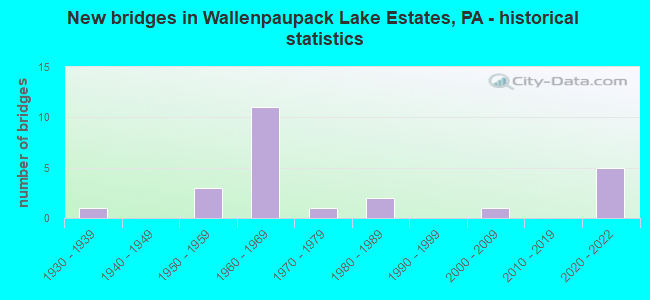
- New bridges - historical statistics
- 11930-1939
- 31950-1959
- 111960-1969
- 11970-1979
- 21980-1989
- 12000-2009
- 52020-2022


- Bridge Condition - Deck
- 6.7%Excellent
- 26.7%Very good
- 33.3%Good
- 6.7%Satisfactory
- 20.0%Fair
- 6.7%Poor

- Bridge Condition - Superstructure
- 6.7%Excellent
- 33.3%Very good
- 13.3%Good
- 13.3%Satisfactory
- 26.7%Fair
- 6.7%Poor

- Bridge Condition - Substructure
- 6.7%Excellent
- 20.0%Very good
- 33.3%Good
- 26.7%Satisfactory
- 13.3%Fair

- Bridge Condition - Channel
- 20.0%Very good
- 30.0%Good
- 40.0%Satisfactory
- 10.0%Poor
Find on map >> Show street view
Structure Number: 29811, Location: GREENE TWP 1.5 M W TR 507 (Lat: 41.346981, Lng: -75.338644), Route carried "on" structure: Interstate 84, Year Built: 1968, Year Reconstructed: 2006, Status: Open, Structure Length: 8.60m (28.22ft), Average Daily Traffic: 10,978 (year 2022), Truck Traffic: 30%, Average Future Daily Traffic: 11,872 (year 2032), Design Load: HS 20+Mod, Features Intersected: WALLENPAUPACK CREEK
Minimum Vertical Clearance: 30+ m (98+ ft), Kilometerpoint: 0.000, Lanes on structure: 2, Base Highway Network: Yes, Owner: State Highway Agency, Approaching Roadway Width: 11.6m (38.1ft), Skew: 13 degrees, Material/Design: Prestressed concrete, Design/Construction: Stringer/Multi-beam, Number Of Spans In Main Unit: 3, Length of Maximum Span: 31.7m (104.0ft), Curb or Sidewalk Widths: Left: 0.2m (0.7ft), Right: 0.2m (0.7ft), Curb-To-Curb Width: 12.0m (39.4ft), Out-to-Out Width: 13.3m (43.6ft)
Condition: Deck: Fair, Superstructure: Fair, Substructure: Fair, Channel: Good, Operating Rating: 80.7 metric tons, Method Used To Determine Operating Rating: Load Factor (LF), Inventory Rating: 20.0 metric tons, Method Used To Determine Inventory Rating: Load Factor (LF), Structural Evaluation: Somewhat better than minimum adequacy, Deck Geometry: Equal to present minimum criteria, Waterway Adequacy: Superior to present desirable criteria, Approach Roadway Alignment: Equal to present desirable criteria, Length Of Structure Improvement: 8.50m (27.89ft), Designated Inspection Frequency: Every 24 months, Inspection Date: Febuary 2021, Bridge Improvement Cost: $69,000, Roadway Improvement Cost: $203,000, Total Project Cost: $932,000, Deck Structure Type: Concrete Cast-file-Place, Wearing Surface/Protective System: Wearing Surface: Latex Concrete
Find on map >> Show street view
Structure Number: 29813, Location: GREENE TWP 1.2 M W TR 507 (Lat: 41.344553, Lng: -75.333964), Route carried "on" structure: Interstate 84, Year Built: 1968, Year Reconstructed: 2006, Status: Open, Structure Length: 3.14m (10.30ft), Average Daily Traffic: 10,978 (year 2022), Truck Traffic: 30%, Average Future Daily Traffic: 11,872 (year 2032), Design Load: HS 20+Mod, Features Intersected: TWO ROAD 357 (KUHN HILL)
Minimum Vertical Clearance: 30+ m (98+ ft), Kilometerpoint: 0.109, Lanes on structure: 2, Lanes under structure: 2, Base Highway Network: Yes, Owner: State Highway Agency, Approaching Roadway Width: 11.6m (38.1ft), Skew: 10 degrees, Material/Design: Prestressed concrete, Design/Construction: Box Beam or Girders - Single/Spread, Number Of Spans In Main Unit: 3, Length of Maximum Span: 12.5m (41.0ft), Curb or Sidewalk Widths: Left: 0.2m (0.7ft), Right: 0.2m (0.7ft), Curb-To-Curb Width: 12.0m (39.4ft), Out-to-Out Width: 13.3m (43.6ft)
Condition: Deck: Good, Superstructure: Fair, Substructure: Satisfactory, Operating Rating: 51.7 metric tons, Method Used To Determine Operating Rating: Load Factor (LF), Inventory Rating: 22.7 metric tons, Method Used To Determine Inventory Rating: Load Factor (LF), Structural Evaluation: Somewhat better than minimum adequacy, Deck Geometry: Equal to present minimum criteria, Underclear: High priority of corrective action, Approach Roadway Alignment: Equal to present desirable criteria, Length Of Structure Improvement: 3.10m (10.17ft), Designated Inspection Frequency: Every 24 months, Inspection Date: Febuary 2021, Bridge Improvement Cost: $49,000, Roadway Improvement Cost: $143,000, Total Project Cost: $656,000, Deck Structure Type: Concrete Cast-file-Place, Wearing Surface/Protective System: Wearing Surface: Latex Concrete
Find on map >> Show street view
Structure Number: 29816, Location: GREENE TWP OVER TR 507 (Lat: 41.341667, Lng: -75.316667), Route carried "on" structure: Interstate 84, Year Built: 1968, Status: Open, Structure Length: 3.41m (11.19ft), Average Daily Traffic: 8,807 (year 2021), Truck Traffic: 21%, Average Future Daily Traffic: 11,872 (year 2032), Design Load: HS 20+Mod, Features Intersected: SR 0507 TR 507
Minimum Vertical Clearance: 30+ m (98+ ft), Kilometerpoint: 1.719, Lanes on structure: 2, Lanes under structure: 2, Base Highway Network: Yes, Owner: State Highway Agency, Approaching Roadway Width: 11.6m (38.1ft), Skew: 10 degrees, Material/Design: Prestressed concrete, Design/Construction: Box Beam or Girders - Single/Spread, Number Of Spans In Main Unit: 3, Length of Maximum Span: 14.6m (47.9ft), Curb or Sidewalk Widths: Left: 0.2m (0.7ft), Right: 0.2m (0.7ft), Curb-To-Curb Width: 12.0m (39.4ft), Out-to-Out Width: 13.2m (43.3ft)
Condition: Deck: Good, Superstructure: Fair, Substructure: Satisfactory, Operating Rating: 56.2 metric tons, Method Used To Determine Operating Rating: Load Factor (LF), Inventory Rating: 30.8 metric tons, Method Used To Determine Inventory Rating: Load Factor (LF), Structural Evaluation: Somewhat better than minimum adequacy, Deck Geometry: Equal to present minimum criteria, Underclear: Meets minimum limits, Approach Roadway Alignment: Equal to present desirable criteria, Length Of Structure Improvement: 3.40m (11.15ft), Designated Inspection Frequency: Every 24 months, Inspection Date: Febuary 2021, Bridge Improvement Cost: $38,000, Roadway Improvement Cost: $113,000, Total Project Cost: $518,000, Deck Structure Type: Concrete Cast-file-Place, Wearing Surface/Protective System: Wearing Surface: Latex Concrete
Find on map >> Show street view
Structure Number: 29827, Location: PALMYRA TWP OVER TR 390 (Lat: 41.360819, Lng: -75.202444), Route carried "on" structure: Interstate 84, Year Built: 1968, Year Reconstructed: 2006, Status: Open, Structure Length: 3.60m (11.81ft), Average Daily Traffic: 11,243 (year 2021), Truck Traffic: 21%, Average Future Daily Traffic: 12,559 (year 2032), Design Load: HS 20+Mod, Features Intersected: SR 0390 TR 390
Minimum Vertical Clearance: 30+ m (98+ ft), Kilometerpoint: 11.312, Lanes on structure: 2, Lanes under structure: 2, Base Highway Network: Yes, Owner: State Highway Agency, Approaching Roadway Width: 11.6m (38.1ft), Skew: 12 degrees, Material/Design: Prestressed concrete, Design/Construction: Box Beam or Girders - Single/Spread, Number Of Spans In Main Unit: 3, Length of Maximum Span: 15.2m (49.9ft), Curb or Sidewalk Widths: Left: 0.2m (0.7ft), Right: 0.2m (0.7ft), Curb-To-Curb Width: 12.0m (39.4ft), Out-to-Out Width: 13.2m (43.3ft)
Condition: Deck: Fair, Superstructure: Fair, Substructure: Satisfactory, Operating Rating: 65.3 metric tons, Method Used To Determine Operating Rating: Load Factor (LF), Inventory Rating: 29.9 metric tons, Method Used To Determine Inventory Rating: Load Factor (LF), Structural Evaluation: Somewhat better than minimum adequacy, Deck Geometry: Equal to present minimum criteria, Underclear: Meets minimum limits, Approach Roadway Alignment: Equal to present desirable criteria, Length Of Structure Improvement: 3.60m (11.81ft), Designated Inspection Frequency: Every 24 months, Inspection Date: Febuary 2021, Bridge Improvement Cost: $39,000, Roadway Improvement Cost: $115,000, Total Project Cost: $528,000, Deck Structure Type: Concrete Cast-file-Place, Wearing Surface/Protective System: Wearing Surface: Latex Concrete
Find on map >> Show street view
Structure Number: 29914, Location: PALMYRA TWP 3.9M N SR4001 (Lat: 41.371053, Lng: -75.252242), Route carried "on" structure: State highway 507, Year Built: 1957, Status: Open, Structure Length: 0.64m (2.10ft), Average Daily Traffic: 2,986 (year 2021), Truck Traffic: 4%, Average Future Daily Traffic: 3,171 (year 2032), Design Load: HS 20, Features Intersected: KLEINHANS CREEK
Minimum Vertical Clearance: 30+ m (98+ ft), Kilometerpoint: 10.775, Lanes on structure: 2, Base Highway Network: Yes, Owner: State Highway Agency, Approaching Roadway Width: 10.7m (35.1ft), Skew: 1 degrees, Material/Design: Concrete, Design/Construction: Culvert, Number Of Spans In Main Unit: 1, Length of Maximum Span: 6.4m (21.0ft)
Condition: Channel: Satisfactory, Culverts: Good, Operating Rating: 49.0 metric tons, Method Used To Determine Operating Rating: Field evaluation and documented engineering judgment, Inventory Rating: 32.7 metric tons, Method Used To Determine Inventory Rating: Field evaluation and documented engineering judgment, Structural Evaluation: Better than present minimum criteria, Waterway Adequacy: Equal to present desirable criteria, Approach Roadway Alignment: Equal to present desirable criteria, Length Of Structure Improvement: 0.60m (1.97ft), Designated Inspection Frequency: Every 48 months, Inspection Date: June 2019, Bridge Improvement Cost: $16,000, Roadway Improvement Cost: $100,000, Total Project Cost: $210,000
Find on map >> Show street view
Structure Number: 30002, Location: GREENE TWP 150' S SR 3006 (Lat: 41.367989, Lng: -75.319767), Route carried "on" structure: State highway , Year Built: 1975, Status: Open, Structure Length: 7.77m (25.49ft), Average Daily Traffic: 2,554 (year 2021), Truck Traffic: 4%, Average Future Daily Traffic: 2,998 (year 2032), Design Load: HS 20, Features Intersected: WALLENPAUPACK CREEK, Facility Carried by Structure: SR4001 LEDGEDLE RD
Minimum Vertical Clearance: 30+ m (98+ ft), Kilometerpoint: 2.285, Lanes on structure: 2, Owner: State Highway Agency, Approaching Roadway Width: 8.8m (28.9ft), Material/Design: Steel continuous, Design/Construction: Stringer/Multi-beam, Number Of Spans In Main Unit: 2, Length of Maximum Span: 38.1m (125.0ft), Curb or Sidewalk Widths: Left: 0.2m (0.7ft), Right: 1.5m (4.9ft), Curb-To-Curb Width: 9.1m (29.9ft), Out-to-Out Width: 11.6m (38.1ft)
Condition: Deck: Satisfactory, Superstructure: Satisfactory, Substructure: Satisfactory, Channel: Very good, Operating Rating: 64.4 metric tons, Method Used To Determine Operating Rating: Load Factor (LF), Inventory Rating: 39.0 metric tons, Method Used To Determine Inventory Rating: Load Factor (LF), Structural Evaluation: Equal to present minimum criteria, Deck Geometry: Meets minimum limits, Waterway Adequacy: Superior to present desirable criteria, Approach Roadway Alignment: Equal to present desirable criteria, Length Of Structure Improvement: 7.80m (25.59ft), Designated Inspection Frequency: Every 24 months, Underwater Inspection Frequency: Every 24 months, Inspection Date: May 2021, Underwater Inspection Date: August 2017, Bridge Improvement Cost: $27,000, Roadway Improvement Cost: $100,000, Total Project Cost: $365,000, Deck Structure Type: Concrete Cast-file-Place, Wearing Surface/Protective System: Wearing Surface: Bituminous, Membrane: Preformed Fabric
Find on map >> Show street view
Structure Number: 30059, Location: 1.5 MI WEST OF SR 390 (Lat: 41.349556, Lng: -75.229158), Route carried "on" structure: City street , Year Built: 1958, Status: Open, Structure Length: 0.88m (2.89ft), Average Daily Traffic: 50 (year 2013), Average Future Daily Traffic: 70 (year 2033), Design Load: HS 20, Features Intersected: KLEINHANS CREEK, Facility Carried by Structure: T351 OLD GREENTOWN
Minimum Vertical Clearance: 30+ m (98+ ft), Kilometerpoint: 0.000, Lanes on structure: 2, Owner: Town or Township Highway Agency, Approaching Roadway Width: 6.1m (20.0ft), Skew: 3 degrees, Material/Design: Prestressed concrete, Design/Construction: Box Beam or Girders - Multiple, Number Of Spans In Main Unit: 1, Length of Maximum Span: 7.9m (25.9ft), Curb or Sidewalk Widths: Left: 0.2m (0.7ft), Right: 0.2m (0.7ft), Curb-To-Curb Width: 6.9m (22.6ft), Out-to-Out Width: 7.3m (24.0ft)
Condition: Deck: Poor, Superstructure: Poor, Substructure: Good, Channel: Satisfactory, Operating Rating: 73.5 metric tons, Method Used To Determine Operating Rating: Load Factor (LF), Inventory Rating: 44.5 metric tons, Method Used To Determine Inventory Rating: Load Factor (LF), Structural Evaluation: Meets minimum limits, Deck Geometry: Somewhat better than minimum adequacy, Waterway Adequacy: Better than present minimum criteria, Approach Roadway Alignment: Equal to present desirable criteria, Length Of Structure Improvement: 1.60m (5.25ft), Designated Inspection Frequency: Every 24 months, Inspection Date: September 2019, Deck Structure Type: Other, Wearing Surface/Protective System: Wearing Surface: Bituminous
Find on map >> Show street view
Structure Number: 35674, Location: SALEM TWP .8 M S SR 3008 (Lat: 41.388956, Lng: -75.323694), Route carried "on" structure: State highway , Year Built: 1956, Year Reconstructed: 2011, Status: Open, Structure Length: 2.26m (7.41ft), Average Daily Traffic: 529 (year 2020), Truck Traffic: 6%, Average Future Daily Traffic: 579 (year 2032), Design Load: HS 20, Features Intersected: ARIEL CREEK, Facility Carried by Structure: SR 3006 LEDGDLE RD
Minimum Vertical Clearance: 30+ m (98+ ft), Kilometerpoint: 9.345, Lanes on structure: 2, Owner: State Highway Agency, Approaching Roadway Width: 7.9m (25.9ft), Skew: 4 degrees, Material/Design: Prestressed concrete, Design/Construction: Box Beam or Girders - Multiple, Number Of Spans In Main Unit: 1, Length of Maximum Span: 21.9m (71.9ft), Curb-To-Curb Width: 8.1m (26.6ft), Out-to-Out Width: 8.6m (28.2ft)
Condition: Deck: Very good, Superstructure: Very good, Substructure: Good, Channel: Satisfactory, Operating Rating: 70.8 metric tons, Method Used To Determine Operating Rating: Load and Resistance Factor (LRFR), Inventory Rating: 43.5 metric tons, Method Used To Determine Inventory Rating: Load and Resistance Factor (LRFR), Structural Evaluation: Better than present minimum criteria, Deck Geometry: Somewhat better than minimum adequacy, Waterway Adequacy: Better than present minimum criteria, Approach Roadway Alignment: Equal to present desirable criteria, Length Of Structure Improvement: 2.20m (7.22ft), Designated Inspection Frequency: Every 48 months, Inspection Date: April 2021, Bridge Improvement Cost: $24,000, Roadway Improvement Cost: $100,000, Total Project Cost: $325,000, Wearing Surface/Protective System: Wearing Surface: Monolithic Concrete, Deck Protection: Epoxy Coated Reinforcing
Find on map >> Show street view
Structure Number: 35681, Location: SALEM TWP 358' E SR 3006 (Lat: 41.379539, Lng: -75.317306), Route carried "on" structure: State highway , Year Built: 1989, Status: Open, Structure Length: 2.71m (8.89ft), Average Daily Traffic: 953 (year 2021), Truck Traffic: 4%, Average Future Daily Traffic: 1,438 (year 2032), Design Load: HS 25 or greater, Features Intersected: ARIEL CREEK, Facility Carried by Structure: SR3013 S MRY CH RD
Minimum Vertical Clearance: 30+ m (98+ ft), Kilometerpoint: 0.000, Lanes on structure: 2, Owner: State Highway Agency, Approaching Roadway Width: 7.3m (24.0ft), Skew: 1 degrees, Material/Design: Prestressed concrete, Design/Construction: Box Beam or Girders - Single/Spread, Number Of Spans In Main Unit: 1, Length of Maximum Span: 26.8m (87.9ft), Curb or Sidewalk Widths: Left: 0.2m (0.7ft), Right: 0.2m (0.7ft), Curb-To-Curb Width: 9.8m (32.2ft), Out-to-Out Width: 10.6m (34.8ft)
Condition: Deck: Good, Superstructure: Good, Substructure: Good, Channel: Good, Operating Rating: 95.3 metric tons, Method Used To Determine Operating Rating: Load Factor (LF), Inventory Rating: 32.7 metric tons, Method Used To Determine Inventory Rating: Load Factor (LF), Structural Evaluation: Better than present minimum criteria, Deck Geometry: Equal to present minimum criteria, Waterway Adequacy: Superior to present desirable criteria, Approach Roadway Alignment: Somewhat better than minimum adequacy, Length Of Structure Improvement: 3.50m (11.48ft), Designated Inspection Frequency: Every 24 months, Inspection Date: April 2021, Deck Structure Type: Concrete Cast-file-Place, Wearing Surface/Protective System: Wearing Surface: Monolithic Concrete, Deck Protection: Epoxy Coated Reinforcing
Find on map >> Show street view
Structure Number: 35683, Location: PAUPACK TWP .5M S SR 2002 (Lat: 41.399861, Lng: -75.288639), Route carried "on" structure: State highway , Year Built: 1988, Status: Open, Structure Length: 1.52m (4.99ft), Average Daily Traffic: 512 (year 2021), Truck Traffic: 5%, Average Future Daily Traffic: 888 (year 2032), Design Load: H 20, Features Intersected: PURDY CREEK, Facility Carried by Structure: SR 3015 FINN SWAMP
Minimum Vertical Clearance: 30+ m (98+ ft), Kilometerpoint: 3.734, Lanes on structure: 2, Owner: State Highway Agency, Approaching Roadway Width: 7.3m (24.0ft), Skew: 3 degrees, Material/Design: Prestressed concrete, Design/Construction: Box Beam or Girders - Single/Spread, Number Of Spans In Main Unit: 1, Length of Maximum Span: 14.9m (48.9ft), Curb or Sidewalk Widths: Left: 0.2m (0.7ft), Right: 0.2m (0.7ft), Curb-To-Curb Width: 8.5m (27.9ft), Out-to-Out Width: 9.4m (30.8ft)
Condition: Deck: Good, Superstructure: Good, Substructure: Good, Channel: Satisfactory, Inventory Rating: 60.8 metric tons, Method Used To Determine Inventory Rating: Load Factor (LF), Structural Evaluation: Better than present minimum criteria, Deck Geometry: Somewhat better than minimum adequacy, Waterway Adequacy: Better than present minimum criteria, Approach Roadway Alignment: Somewhat better than minimum adequacy, Length Of Structure Improvement: 2.20m (7.22ft), Designated Inspection Frequency: Every 48 months, Inspection Date: April 2021, Deck Structure Type: Concrete Cast-file-Place, Wearing Surface/Protective System: Wearing Surface: Monolithic Concrete, Deck Protection: Epoxy Coated Reinforcing
Find on map >> Show street view
Structure Number: 35727, Location: PAUPACK TWP .3 M W TR 590 (Lat: 41.437133, Lng: -75.281389), Route carried "on" structure: State highway , Year Built: 1934, Status: Open, Structure Length: 1.04m (3.41ft), Average Daily Traffic: 367 (year 2021), Truck Traffic: 6%, Average Future Daily Traffic: 525 (year 2032), Design Load: HS 20, Features Intersected: ALPHA CREEK, Facility Carried by Structure: SR 3040 AVOY RD
Minimum Vertical Clearance: 30+ m (98+ ft), Kilometerpoint: 8.269, Lanes on structure: 2, Owner: State Highway Agency, Approaching Roadway Width: 6.4m (21.0ft), Skew: 3 degrees, Material/Design: Concrete, Design/Construction: Tee Beam, Number Of Spans In Main Unit: 1, Length of Maximum Span: 9.8m (32.2ft), Curb or Sidewalk Widths: Left: 0.2m (0.7ft), Right: 0.2m (0.7ft), Curb-To-Curb Width: 7.2m (23.6ft), Out-to-Out Width: 7.9m (25.9ft)
Condition: Deck: Fair, Superstructure: Satisfactory, Substructure: Fair, Channel: Poor, Operating Rating: 51.7 metric tons, Method Used To Determine Operating Rating: Load Factor (LF), Inventory Rating: 30.8 metric tons, Method Used To Determine Inventory Rating: Load Factor (LF), Structural Evaluation: Somewhat better than minimum adequacy, Deck Geometry: Meets minimum limits, Waterway Adequacy: Better than present minimum criteria, Approach Roadway Alignment: Equal to present desirable criteria, Length Of Structure Improvement: 1.00m (3.28ft), Designated Inspection Frequency: Every 24 months, Inspection Date: March 2021, Deck Structure Type: Concrete Cast-file-Place, Wearing Surface/Protective System: Wearing Surface: Bituminous
Find on map >> Show street view
Structure Number: 4571, Location: SALEM TWP. .2 M N SR 3013 (Lat: 41.381797, Lng: -75.320611), Route carried "on" structure: State highway , Year Built: 2009, Status: Open, Structure Length: 1.71m (5.61ft), Average Daily Traffic: 529 (year 2020), Truck Traffic: 6%, Average Future Daily Traffic: 579 (year 2032), Design Load: HS 25 or greater, Features Intersected: ARIEL CREEK, Facility Carried by Structure: SR 3006
Minimum Vertical Clearance: 30.18m (99.02ft), Kilometerpoint: 8.641, Lanes on structure: 2, Owner: State Highway Agency, Approaching Roadway Width: 9.8m (32.2ft), Skew: 1 degrees, Material/Design: Prestressed concrete, Design/Construction: Box Beam or Girders - Single/Spread, Number Of Spans In Main Unit: 1, Length of Maximum Span: 16.5m (54.1ft), Curb or Sidewalk Widths: Left: 0.2m (0.7ft), Right: 0.2m (0.7ft), Curb-To-Curb Width: 9.8m (32.2ft), Out-to-Out Width: 10.9m (35.8ft)
Condition: Deck: Good, Superstructure: Very good, Substructure: Good, Channel: Good, Operating Rating: 93.4 metric tons, Method Used To Determine Operating Rating: Load Factor (LF), Inventory Rating: 56.2 metric tons, Method Used To Determine Inventory Rating: Load Factor (LF), Structural Evaluation: Better than present minimum criteria, Deck Geometry: Equal to present minimum criteria, Waterway Adequacy: Better than present minimum criteria, Approach Roadway Alignment: Better than present minimum criteria, Designated Inspection Frequency: Every 48 months, Inspection Date: May 2021, Deck Structure Type: Concrete Cast-file-Place, Wearing Surface/Protective System: Wearing Surface: Monolithic Concrete, Deck Protection: Epoxy Coated Reinforcing
Find on map >> Show street view
Structure Number: 67988, Location: GREENE TWP 1.5 M W TR 507 (Lat: 41.347317, Lng: -75.338583), Route carried "on" structure: Interstate 84, Year Built: 2021, Status: Open, Structure Length: 8.60m (28.22ft), Average Daily Traffic: 9,827 (year 2022), Truck Traffic: 31%, Average Future Daily Traffic: 11,989 (year 2041), Design Load: HL 93, Features Intersected: WALLENPAUPACK CREEK
Minimum Vertical Clearance: 30+ m (98+ ft), Kilometerpoint: 0.000, Lanes on structure: 2, Base Highway Network: Yes, Owner: State Highway Agency, Approaching Roadway Width: 13.4m (44.0ft), Skew: 3 degrees, Material/Design: Prestressed concrete, Design/Construction: Tee Beam, Number Of Spans In Main Unit: 3, Length of Maximum Span: 33.5m (109.9ft), Curb or Sidewalk Widths: Left: 0.2m (0.7ft), Right: 0.2m (0.7ft), Curb-To-Curb Width: 13.4m (44.0ft), Out-to-Out Width: 14.4m (47.2ft)
Condition: Deck: Excellent, Superstructure: Excellent, Substructure: Excellent, Channel: Very good, Operating Rating: 48.3 metric tons, Method Used To Determine Operating Rating: Assigned ratings based on Load and Resistance Factor Design (LRFD) reported by rating factor (RF) using HL93 loadings, Inventory Rating: 37.3 metric tons, Method Used To Determine Inventory Rating: Assigned ratings based on Load and Resistance Factor Design (LRFD) reported by rating factor (RF) using HL93 loadings, Structural Evaluation: Superior to present desirable criteria, Deck Geometry: Superior to present desirable criteria, Waterway Adequacy: Superior to present desirable criteria, Approach Roadway Alignment: Equal to present desirable criteria, Designated Inspection Frequency: Every 24 months, Inspection Date: Febuary 2021, Deck Structure Type: Concrete Cast-file-Place, Wearing Surface/Protective System: Wearing Surface: Latex Concrete, Deck Protection: Epoxy Coated Reinforcing
Find on map >> Show street view
Structure Number: 68022, Location: GREENE TWP OVER TR 507 (Lat: 41.341667, Lng: -75.316667), Route carried "on" structure: Interstate 84, Year Built: 2021, Status: Open, Structure Length: 1.86m (6.10ft), Average Daily Traffic: 9,322 (year 2021), Truck Traffic: 29%, Average Future Daily Traffic: 7,429 (year 2040), Design Load: HL 93, Features Intersected: SR 0507 TR 507
Minimum Vertical Clearance: 30+ m (98+ ft), Kilometerpoint: 1.708, Lanes on structure: 2, Lanes under structure: 2, Base Highway Network: Yes, Owner: State Highway Agency, Approaching Roadway Width: 13.4m (44.0ft), Material/Design: Prestressed concrete, Design/Construction: Box Beam or Girders - Single/Spread, Number Of Spans In Main Unit: 1, Length of Maximum Span: 17.7m (58.1ft), Curb or Sidewalk Widths: Left: 0.2m (0.7ft), Right: 0.2m (0.7ft), Curb-To-Curb Width: 13.4m (44.0ft), Out-to-Out Width: 14.4m (47.2ft)
Condition: Deck: Very good, Superstructure: Very good, Substructure: Very good, Operating Rating: 48.0 metric tons, Method Used To Determine Operating Rating: Assigned ratings based on Load and Resistance Factor Design (LRFD) reported by rating factor (RF) using HL93 loadings, Inventory Rating: 35.3 metric tons, Method Used To Determine Inventory Rating: Assigned ratings based on Load and Resistance Factor Design (LRFD) reported by rating factor (RF) using HL93 loadings, Structural Evaluation: Equal to present desirable criteria, Deck Geometry: Superior to present desirable criteria, Underclear: High priority of corrective action, Approach Roadway Alignment: Equal to present desirable criteria, Designated Inspection Frequency: Every 24 months, Inspection Date: Febuary 2021, Deck Structure Type: Concrete Cast-file-Place, Wearing Surface/Protective System: Wearing Surface: Latex Concrete, Deck Protection: Epoxy Coated Reinforcing
Find on map >> Show street view
Structure Number: 68034, Location: PALMYRA TWP .6 M W TR 390 (Lat: 41.359278, Lng: -75.215194), Route carried "on" structure: Interstate 84, Year Built: 2021, Status: Open, Structure Length: 1.86m (6.10ft), Average Daily Traffic: 8,807 (year 2021), Truck Traffic: 21%, Average Future Daily Traffic: 7,374 (year 2040), Design Load: HL 93, Features Intersected: T-390 (SHINY MT RD)
Minimum Vertical Clearance: 30+ m (98+ ft), Kilometerpoint: 10.569, Lanes on structure: 2, Lanes under structure: 2, Base Highway Network: Yes, Owner: State Highway Agency, Approaching Roadway Width: 13.4m (44.0ft), Skew: 1 degrees, Material/Design: Prestressed concrete, Design/Construction: Box Beam or Girders - Single/Spread, Number Of Spans In Main Unit: 1, Length of Maximum Span: 17.7m (58.1ft), Curb or Sidewalk Widths: Left: 0.2m (0.7ft), Right: 0.2m (0.7ft), Curb-To-Curb Width: 13.4m (44.0ft), Out-to-Out Width: 14.4m (47.2ft)
Condition: Deck: Very good, Superstructure: Very good, Substructure: Very good, Operating Rating: 58.6 metric tons, Method Used To Determine Operating Rating: Assigned ratings based on Load and Resistance Factor Design (LRFD) reported by rating factor (RF) using HL93 loadings, Inventory Rating: 43.4 metric tons, Method Used To Determine Inventory Rating: Assigned ratings based on Load and Resistance Factor Design (LRFD) reported by rating factor (RF) using HL93 loadings, Structural Evaluation: Equal to present desirable criteria, Deck Geometry: Superior to present desirable criteria, Underclear: Equal to present minimum criteria, Approach Roadway Alignment: Equal to present desirable criteria, Designated Inspection Frequency: Every 24 months, Inspection Date: Febuary 2021, Deck Structure Type: Concrete Cast-file-Place, Wearing Surface/Protective System: Wearing Surface: Latex Concrete, Deck Protection: Epoxy Coated Reinforcing
Find on map >> Show street view
Structure Number: 68058, Location: GREENE TWP 1.2 M W TR 507 (Lat: 41.344878, Lng: -75.333906), Route carried "on" structure: Interstate 84, Year Built: 2021, Status: Open, Structure Length: 1.83m (6.00ft), Average Daily Traffic: 9,827 (year 2022), Truck Traffic: 31%, Average Future Daily Traffic: 11,989 (year 2041), Design Load: HL 93, Features Intersected: TWP ROAD 357 (KUHN HILL)
Minimum Vertical Clearance: 30+ m (98+ ft), Kilometerpoint: 0.103, Lanes on structure: 2, Lanes under structure: 2, Base Highway Network: Yes, Owner: State Highway Agency, Approaching Roadway Width: 13.4m (44.0ft), Skew: 1 degrees, Material/Design: Prestressed concrete, Design/Construction: Box Beam or Girders - Single/Spread, Number Of Spans In Main Unit: 1, Length of Maximum Span: 17.7m (58.1ft), Curb or Sidewalk Widths: Left: 0.2m (0.7ft), Right: 0.2m (0.7ft), Curb-To-Curb Width: 13.5m (44.3ft), Out-to-Out Width: 14.5m (47.6ft)
Condition: Deck: Very good, Superstructure: Very good, Substructure: Very good, Operating Rating: 51.5 metric tons, Method Used To Determine Operating Rating: Assigned ratings based on Load and Resistance Factor Design (LRFD) reported by rating factor (RF) using HL93 loadings, Inventory Rating: 39.9 metric tons, Method Used To Determine Inventory Rating: Assigned ratings based on Load and Resistance Factor Design (LRFD) reported by rating factor (RF) using HL93 loadings, Structural Evaluation: Equal to present desirable criteria, Deck Geometry: Superior to present desirable criteria, Underclear: Superior to present desirable criteria, Approach Roadway Alignment: Equal to present desirable criteria, Designated Inspection Frequency: Every 24 months, Inspection Date: Febuary 2021, Deck Structure Type: Concrete Cast-file-Place, Wearing Surface/Protective System: Wearing Surface: Latex Concrete, Deck Protection: Epoxy Coated Reinforcing
Find on map >> Show street view
Structure Number: 29813, Location: GREENE TWP 1.2 M W TR 507 (Lat: 41.344553, Lng: -75.333964), Route carried "under" structure: City street , Year Built: 1968, Structure Length: 0. m, Average Daily Traffic: 200 (year 1992), Features Intersected: TWO ROAD 357 (KUHN HILL), Facility Carried by Structure: SR 0084 I-84 EB
Minimum Vertical Clearance: 4.14m (13.58ft), Kilometerpoint: 0.000, Lanes on structure: 2, Lanes under structure: 2, Material/Design: Prestressed concrete, Design/Construction: Box Beam or Girders - Single/Spread, Length of Maximum Span: 12.5m (41.0ft)
Find on map >> Show street view
Structure Number: 29816, Location: GREENE TWP OVER TR 507 (Lat: 41.341667, Lng: -75.316667), Route carried "under" structure: State highway 507, Year Built: 1968, Structure Length: 0. m, Average Daily Traffic: 5,150 (year 2020), Truck Traffic: 6%, Features Intersected: SR 0507 TR 507, Facility Carried by Structure: SR 0084 I-84 EB
Minimum Vertical Clearance: 5.08m (16.67ft), Kilometerpoint: 2.829, Lanes on structure: 2, Lanes under structure: 2, Material/Design: Prestressed concrete, Design/Construction: Box Beam or Girders - Single/Spread, Length of Maximum Span: 14.6m (47.9ft)
Find on map >> Show street view
Structure Number: 29819, Location: GREENE TWP 1 M E TR 507 (Lat: 41.341181, Lng: -75.296822), Route carried "under" structure: Interstate 84, Year Built: 1968, Structure Length: 0. m, Average Daily Traffic: 8,807 (year 2021), Truck Traffic: 21%, Features Intersected: SR 0084 I-84, Facility Carried by Structure: T-389 BEAVR RUN RD
Minimum Vertical Clearance: 9.39m (30.81ft), Kilometerpoint: 3.330, Lanes on structure: 2, Lanes under structure: 2, Material/Design: Prestressed concrete, Design/Construction: Box Beam or Girders - Single/Spread, Length of Maximum Span: 20.1m (65.9ft)
Find on map >> Show street view
Structure Number: 29819, Location: GREENE TWP 1 M E TR 507 (Lat: 41.341181, Lng: -75.296822), Route carried "under" structure: Interstate 84, Year Built: 1968, Structure Length: 0. m, Average Daily Traffic: 9,322 (year 2021), Truck Traffic: 29%, Features Intersected: SR 0084 I-84, Facility Carried by Structure: T-389 BEAVR RUN RD
Minimum Vertical Clearance: 5.43m (17.81ft), Kilometerpoint: 3.302, Lanes on structure: 2, Lanes under structure: 2, Material/Design: Prestressed concrete, Design/Construction: Box Beam or Girders - Single/Spread, Length of Maximum Span: 20.1m (65.9ft)
Find on map >> Show street view
Structure Number: 29825, Location: PALMYRA TWP .6 M W TR 390 (Lat: 41.359986, Lng: -75.215289), Route carried "under" structure: City street , Year Built: 1968, Structure Length: 0. m, Average Daily Traffic: 200 (year 1992), Features Intersected: TWP ROAD 390 (SHINY MT), Facility Carried by Structure: SR 0084 I-84 WB
Minimum Vertical Clearance: 4.34m (14.24ft), Kilometerpoint: 0.000, Lanes on structure: 2, Lanes under structure: 2, Material/Design: Prestressed concrete, Design/Construction: Box Beam or Girders - Single/Spread, Length of Maximum Span: 11.3m (37.1ft)
Find on map >> Show street view
Structure Number: 29826, Location: PALMYRA TWP OVER TR 390 (Lat: 41.360533, Lng: -75.202764), Route carried "under" structure: State highway 390, Year Built: 1968, Structure Length: 0. m, Average Daily Traffic: 1,983 (year 2021), Truck Traffic: 4%, Features Intersected: SR 0390 TR 390, Facility Carried by Structure: SR 0084 I-84 EB
Minimum Vertical Clearance: 4.34m (14.24ft), Kilometerpoint: 16.179, Lanes on structure: 2, Lanes under structure: 2, Material/Design: Prestressed concrete, Design/Construction: Box Beam or Girders - Single/Spread, Length of Maximum Span: 15.2m (49.9ft)
Find on map >> Show street view
Structure Number: 29827, Location: PALMYRA TWP OVER TR 390 (Lat: 41.360819, Lng: -75.202444), Route carried "under" structure: State highway 390, Year Built: 1968, Structure Length: 0. m, Average Daily Traffic: 1,983 (year 2021), Truck Traffic: 4%, Features Intersected: SR 0390 TR 390, Facility Carried by Structure: SR 0084 I-84 WB
Minimum Vertical Clearance: 4.47m (14.67ft), Kilometerpoint: 16.179, Lanes on structure: 2, Lanes under structure: 2, Material/Design: Prestressed concrete, Design/Construction: Box Beam or Girders - Single/Spread, Length of Maximum Span: 15.2m (49.9ft)
Find on map >> Show street view
Structure Number: 68022, Location: GREENE TWP OVER TR 507 (Lat: 41.341667, Lng: -75.316667), Route carried "under" structure: State highway 507, Year Built: 2021, Structure Length: 0. m, Average Daily Traffic: 5,150 (year 2020), Truck Traffic: 6%, Features Intersected: SR 0507 TR 507, Facility Carried by Structure: SR 0084 I-84 WB
Minimum Vertical Clearance: 5.23m (17.16ft), Kilometerpoint: 2.829, Lanes on structure: 2, Lanes under structure: 2, Material/Design: Prestressed concrete, Design/Construction: Box Beam or Girders - Single/Spread, Length of Maximum Span: 17.7m (58.1ft)