Bridge Statistics for Wakefield, Michigan (MI)
Condition, Traffic, Stress, Structural Evaluation, Project Costs
- National Bridge Inventory (NBI) Statistics
- 20Number of bridges
- 118ft / 36.0mTotal length
- $3,025,000Total costs
- 23,273Total average daily traffic
- 2,101Total average daily truck traffic
- 848,394Total future (year 2007) average daily traffic
- National Bridge Inventory (NBI) Registered Bridges for Wakefield
- No street view available for this location
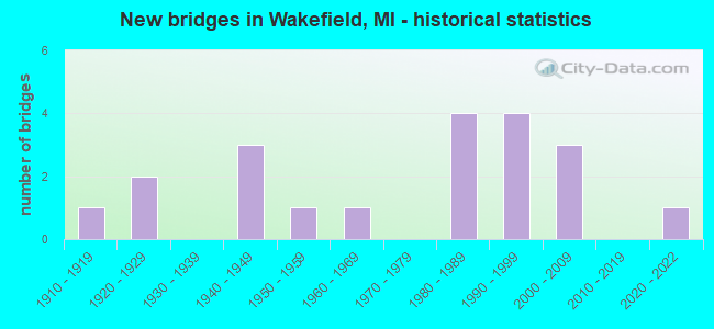
- New bridges - historical statistics
- 11910-1919
- 21920-1929
- 31940-1949
- 11950-1959
- 11960-1969
- 41980-1989
- 41990-1999
- 32000-2009
- 12020-2022

- Reconstructed bridges - Historical Statistics
- 11990-1999
- 32000-2009


- Bridge Condition - Deck
- 6.3%Excellent
- 6.3%Very good
- 37.5%Good
- 18.8%Satisfactory
- 18.8%Fair
- 12.5%Poor

- Bridge Condition - Superstructure
- 6.3%Excellent
- 12.5%Very good
- 37.5%Good
- 12.5%Satisfactory
- 18.8%Fair
- 12.5%Serious

- Bridge Condition - Substructure
- 6.3%Excellent
- 18.8%Very good
- 25.0%Good
- 18.8%Satisfactory
- 18.8%Fair
- 12.5%Poor

- Bridge Condition - Channel
- 5.0%Excellent
- 20.0%Very good
- 55.0%Good
- 10.0%Satisfactory
- 10.0%Fair

- Bridge Condition - Culverts
- 75.0%Good
- 25.0%Fair
Find on map >> Show street view
Structure Number: 1363, Location: 6 MI N OF BURLINGTON (Lat: 42.192525, Lng: -85.060328), Route carried "on" structure: County highway , Year Built: 1919, Status: Posted for load, Structure Length: 0.64m (2.10ft), Average Daily Traffic: 439 (year 1994), Truck Traffic: 5%, Average Future Daily Traffic: 819 (year 2024), Design Load: H 15, Features Intersected: NOTTAWASSEPEE CREEK, Facility Carried by Structure: 12 MILE ROAD
Minimum Vertical Clearance: 30.48m (100.00ft), Kilometerpoint: 3.228, Lanes on structure: 2, Owner: County Highway Agency, Approaching Roadway Width: 9.1m (29.9ft), Material/Design: Steel, Design/Construction: Stringer/Multi-beam, Number Of Spans In Main Unit: 1, Length of Maximum Span: 6.4m (21.0ft), Curb-To-Curb Width: 7.0m (23.0ft), Out-to-Out Width: 7.6m (24.9ft)
Condition: Deck: Poor, Superstructure: Serious, Substructure: Poor, Channel: Fair, Operating Rating: 30.5 metric tons, Method Used To Determine Operating Rating: Load Factor (LF) rating reported by rating factor (RF) method using MS18 loading, Inventory Rating: 18.1 metric tons, Method Used To Determine Inventory Rating: Load Factor (LF) rating reported by rating factor (RF) method using MS18 loading, Structural Evaluation: High priority of corrective action, Deck Geometry: Meets minimum limits, Waterway Adequacy: Equal to present desirable criteria, Approach Roadway Alignment: Equal to present desirable criteria, Bridge Posting: Required (Relationship of Operating Rating to Maximum Legal Load: 30.0 - 39.9% below), Length Of Structure Improvement: 1.28m (4.20ft), Designated Inspection Frequency: Every 12 months, Inspection Date: September 2021, Bridge Improvement Cost: $117,000, Roadway Improvement Cost: $95,000, Total Project Cost: $212,000, Deck Structure Type: Concrete Cast-file-Place, Wearing Surface/Protective System: Wearing Surface: Bituminous
Find on map >> Show street view
Structure Number: 2946, Location: 2.0 MI E OF BESSEMER (Lat: 46.482597, Lng: -89.999547), Route carried "on" structure: US 2, Year Built: 1947, Year Reconstructed: 2005, Status: Open, Structure Length: 5.49m (18.01ft), Average Daily Traffic: 5,286 (year 2007), Truck Traffic: 11%, Average Future Daily Traffic: 820,000 (year 2026), Design Load: HS 20, Features Intersected: BLACK RIVER
Minimum Vertical Clearance: 30.48m (100.00ft), Kilometerpoint: 15.577, Lanes on structure: 5, Base Highway Network: Yes (Inventory Route: 147, Subroute: 1), Owner: State Highway Agency, Approaching Roadway Width: 25.5m (83.7ft), Material/Design: Steel, Design/Construction: Stringer/Multi-beam, Number Of Spans In Main Unit: 3, Length of Maximum Span: 18.3m (60.0ft), Curb-To-Curb Width: 25.5m (83.7ft), Out-to-Out Width: 26.2m (86.0ft)
Condition: Deck: Satisfactory, Superstructure: Good, Substructure: Satisfactory, Channel: Good, Operating Rating: 76.5 metric tons, Method Used To Determine Operating Rating: Load Factor (LF) rating reported by rating factor (RF) method using MS18 loading, Inventory Rating: 51.2 metric tons, Method Used To Determine Inventory Rating: Load Factor (LF) rating reported by rating factor (RF) method using MS18 loading, Structural Evaluation: Equal to present minimum criteria, Deck Geometry: Superior to present desirable criteria, Waterway Adequacy: Better than present minimum criteria, Approach Roadway Alignment: Equal to present minimum criteria, Length Of Structure Improvement: 5.49m (18.01ft), Designated Inspection Frequency: Every 24 months, Inspection Date: August 2021, Bridge Improvement Cost: $181,000, Deck Structure Type: Concrete Cast-file-Place, Wearing Surface/Protective System: Wearing Surface: Bituminous, Membrane: Preformed Fabric, Deck Protection: Epoxy Coated Reinforcing
Find on map >> Show street view
Structure Number: 2948, Location: IN WAKEFIELD (Lat: 46.477300, Lng: -89.963978), Route carried "on" structure: US 2, Year Built: 1947, Year Reconstructed: 2005, Status: Open, Structure Length: 0.91m (2.99ft), Average Daily Traffic: 5,387 (year 2007), Truck Traffic: 9%, Average Future Daily Traffic: 9,300 (year 2025), Design Load: HS 20, Features Intersected: SUNDAY LAKE OUTLET
Minimum Vertical Clearance: 30.48m (100.00ft), Kilometerpoint: 18.420, Lanes on structure: 4, Base Highway Network: Yes (Inventory Route: 147, Subroute: 1), Owner: State Highway Agency, Approaching Roadway Width: 23.8m (78.1ft), Material/Design: Steel, Design/Construction: Stringer/Multi-beam, Number Of Spans In Main Unit: 1, Length of Maximum Span: 8.4m (27.6ft), Curb-To-Curb Width: 25.5m (83.7ft), Out-to-Out Width: 26.2m (86.0ft)
Condition: Deck: Good, Superstructure: Good, Substructure: Satisfactory, Channel: Good, Operating Rating: 97.2 metric tons, Method Used To Determine Operating Rating: Load Factor (LF) rating reported by rating factor (RF) method using MS18 loading, Inventory Rating: 64.5 metric tons, Method Used To Determine Inventory Rating: Load Factor (LF) rating reported by rating factor (RF) method using MS18 loading, Structural Evaluation: Equal to present minimum criteria, Deck Geometry: Superior to present desirable criteria, Waterway Adequacy: Better than present minimum criteria, Approach Roadway Alignment: Equal to present minimum criteria, Designated Inspection Frequency: Every 24 months, Inspection Date: August 2021, Bridge Improvement Cost: $44,000, Deck Structure Type: Concrete Cast-file-Place, Wearing Surface/Protective System: Wearing Surface: Monolithic Concrete, Deck Protection: Epoxy Coated Reinforcing
Find on map >> Show street view
Structure Number: 2949, Location: IN WAKEFIELD (Lat: 46.476925, Lng: -89.948883), Route carried "on" structure: US 2, Year Built: 1947, Year Reconstructed: 2005, Status: Open, Structure Length: 1.22m (4.00ft), Average Daily Traffic: 5,281 (year 2007), Truck Traffic: 9%, Average Future Daily Traffic: 9,300 (year 2025), Design Load: HS 20+Mod, Features Intersected: LITTLE BLACK RIVER
Minimum Vertical Clearance: 30.48m (100.00ft), Kilometerpoint: 19.580, Lanes on structure: 4, Base Highway Network: Yes (Inventory Route: 147, Subroute: 1), Owner: State Highway Agency, Approaching Roadway Width: 21.8m (71.5ft), Material/Design: Steel, Design/Construction: Stringer/Multi-beam, Number Of Spans In Main Unit: 1, Length of Maximum Span: 11.7m (38.4ft), Curb-To-Curb Width: 21.8m (71.5ft), Out-to-Out Width: 22.5m (73.8ft)
Condition: Deck: Good, Superstructure: Good, Substructure: Fair, Channel: Good, Operating Rating: 84.6 metric tons, Method Used To Determine Operating Rating: Load Factor (LF) rating reported by rating factor (RF) method using MS18 loading, Inventory Rating: 50.5 metric tons, Method Used To Determine Inventory Rating: Load Factor (LF) rating reported by rating factor (RF) method using MS18 loading, Structural Evaluation: Somewhat better than minimum adequacy, Deck Geometry: Superior to present desirable criteria, Waterway Adequacy: Equal to present desirable criteria, Approach Roadway Alignment: Equal to present minimum criteria, Designated Inspection Frequency: Every 24 months, Inspection Date: August 2021, Bridge Improvement Cost: $3,000, Deck Structure Type: Concrete Cast-file-Place, Wearing Surface/Protective System: Wearing Surface: Monolithic Concrete, Deck Protection: Epoxy Coated Reinforcing
Find on map >> Show street view
Structure Number: 2975, Location: SEC 13 BESSEMER TWP (Lat: 46.470722, Lng: -90.000614), Route carried "on" structure: County highway 2752, Year Built: 1991, Status: Open, Structure Length: 1.98m (6.50ft), Average Daily Traffic: 1,111 (year 1998), Truck Traffic: 40%, Average Future Daily Traffic: 1,300 (year 2018), Design Load: HS 20+Mod, Features Intersected: BLACK RIVER, Facility Carried by Structure: OLD US-2
Minimum Vertical Clearance: 30.48m (100.00ft), Kilometerpoint: 0.420, Lanes on structure: 2, Owner: County Highway Agency, Approaching Roadway Width: 9.8m (32.2ft), Material/Design: Prestressed concrete, Design/Construction: Box Beam or Girders - Multiple, Number Of Spans In Main Unit: 1, Length of Maximum Span: 19.2m (63.0ft), Curb or Sidewalk Widths: Left: 1.5m (4.9ft), Right: 0.0m, Curb-To-Curb Width: 9.1m (29.9ft), Out-to-Out Width: 11.3m (37.1ft)
Condition: Deck: Good, Superstructure: Good, Substructure: Good, Channel: Good, Operating Rating: 77.8 metric tons, Method Used To Determine Operating Rating: Load Factor (LF) rating reported by rating factor (RF) method using MS18 loading, Inventory Rating: 46.7 metric tons, Method Used To Determine Inventory Rating: Load Factor (LF) rating reported by rating factor (RF) method using MS18 loading, Structural Evaluation: Better than present minimum criteria, Deck Geometry: Somewhat better than minimum adequacy, Waterway Adequacy: Superior to present desirable criteria, Approach Roadway Alignment: Somewhat better than minimum adequacy, Designated Inspection Frequency: Every 24 months, Inspection Date: September 2020, Deck Structure Type: Concrete Precast Panels, Wearing Surface/Protective System: Wearing Surface: Bituminous, Membrane: Preformed Fabric, Deck Protection: Epoxy Coated Reinforcing
Find on map >> Show street view
Structure Number: 2976, Location: SEC 13 BESSEMER TWP (Lat: 46.473961, Lng: -90.001636), Route carried "on" structure: County highway 2752, Year Built: 1922, Status: Posted for load, Structure Length: 3.96m (12.99ft), Average Daily Traffic: 391 (year 1998), Average Future Daily Traffic: 391 (year 2018), Design Load: H 20, Features Intersected: BLACK RIVER, Facility Carried by Structure: OLD COUNTY ROAD
Minimum Vertical Clearance: 30.48m (100.00ft), Kilometerpoint: 0.114, Lanes on structure: 2, Owner: County Highway Agency, Approaching Roadway Width: 7.3m (24.0ft), Material/Design: Concrete, Design/Construction: Girder and Floorbeam System, Number Of Spans In Main Unit: 3, Length of Maximum Span: 15.2m (49.9ft), Curb-To-Curb Width: 6.7m (22.0ft), Out-to-Out Width: 8.2m (26.9ft)
Condition: Deck: Fair, Superstructure: Serious, Substructure: Fair, Channel: Good, Operating Rating: 21.3 metric tons, Method Used To Determine Operating Rating: Field evaluation and documented engineering judgment, Inventory Rating: 16.4 metric tons, Method Used To Determine Inventory Rating: Field evaluation and documented engineering judgment, Structural Evaluation: High priority of corrective action, Deck Geometry: Meets minimum limits, Waterway Adequacy: Superior to present desirable criteria, Approach Roadway Alignment: Equal to present minimum criteria, Bridge Posting: Required (Relationship of Operating Rating to Maximum Legal Load: > 39.9% below), Length Of Structure Improvement: 4.75m (15.58ft), Designated Inspection Frequency: Every 12 months, Inspection Date: September 2021, Bridge Improvement Cost: $666,000, Roadway Improvement Cost: $67,000, Total Project Cost: $916,000, Deck Structure Type: Concrete Cast-file-Place, Wearing Surface/Protective System: Wearing Surface: Bituminous
Find on map >> Show street view
Structure Number: 2989, Location: SEC 33 WAKEFIELD TWP (Lat: 46.507294, Lng: -89.934944), Route carried "on" structure: County highway 2741, Year Built: 1986, Status: Open, Structure Length: 0.73m (2.40ft), Average Daily Traffic: 544 (year 1990), Truck Traffic: 2%, Average Future Daily Traffic: 544 (year 2018), Design Load: HS 20, Features Intersected: NORTH BR PLANTERS CREEK, Facility Carried by Structure: PRESQUE ISLE ROAD
Minimum Vertical Clearance: 30.48m (100.00ft), Kilometerpoint: 2.454, Lanes on structure: 2, Owner: County Highway Agency, Approaching Roadway Width: 9.1m (29.9ft), Skew: 1 degrees, Material/Design: Concrete, Design/Construction: Culvert, Number Of Spans In Main Unit: 2, Length of Maximum Span: 2.4m (7.9ft)
Condition: Channel: Good, Culverts: Good, Operating Rating: 43.7 metric tons, Method Used To Determine Operating Rating: Allowable Stress (AS), Inventory Rating: 26.2 metric tons, Method Used To Determine Inventory Rating: Allowable Stress (AS), Structural Evaluation: Equal to present minimum criteria, Waterway Adequacy: Superior to present desirable criteria, Approach Roadway Alignment: Equal to present desirable criteria, Designated Inspection Frequency: Every 24 months, Inspection Date: September 2020
Find on map >> Show street view
Structure Number: 299, Location: SEC 27-28 WAKEFIELD TWP (Lat: 46.535522, Lng: -89.928908), Route carried "on" structure: County highway 2727, Year Built: 1986, Status: Open, Structure Length: 3.05m (10.01ft), Average Daily Traffic: 264 (year 2012), Truck Traffic: 3%, Average Future Daily Traffic: 654 (year 2032), Design Load: HS 20+Mod, Features Intersected: JACKSON CREEK, Facility Carried by Structure: PRESQUE ISLE ROAD
Minimum Vertical Clearance: 30.48m (100.00ft), Kilometerpoint: 5.818, Lanes on structure: 2, Owner: County Highway Agency, Approaching Roadway Width: 9.1m (29.9ft), Skew: 1 degrees, Material/Design: Prestressed concrete, Design/Construction: Box Beam or Girders - Multiple, Number Of Spans In Main Unit: 2, Length of Maximum Span: 14.6m (47.9ft), Curb-To-Curb Width: 10.4m (34.1ft), Out-to-Out Width: 10.5m (34.4ft)
Condition: Deck: Very good, Superstructure: Very good, Substructure: Good, Channel: Good, Operating Rating: 62.9 metric tons, Method Used To Determine Operating Rating: Load Factor (LF) rating reported by rating factor (RF) method using MS18 loading, Inventory Rating: 37.6 metric tons, Method Used To Determine Inventory Rating: Load Factor (LF) rating reported by rating factor (RF) method using MS18 loading, Structural Evaluation: Better than present minimum criteria, Deck Geometry: Better than present minimum criteria, Waterway Adequacy: Equal to present desirable criteria, Approach Roadway Alignment: Better than present minimum criteria, Designated Inspection Frequency: Every 24 months, Inspection Date: September 2020, Deck Structure Type: Concrete Precast Panels, Wearing Surface/Protective System: Wearing Surface: Bituminous, Membrane: Preformed Fabric, Deck Protection: Epoxy Coated Reinforcing
Find on map >> Show street view
Structure Number: 3002, Location: SEC 12 BESSEMER TWP (Lat: 46.480997, Lng: -90.000358), Route carried "on" structure: County highway , Year Built: 1993, Status: Open, Structure Length: 2.13m (6.99ft), Average Daily Traffic: 135 (year 1998), Average Future Daily Traffic: 160 (year 2018), Design Load: HS 20+Mod, Features Intersected: BLACK RIVER, Facility Carried by Structure: SANDERS ROAD
Minimum Vertical Clearance: 30.48m (100.00ft), Kilometerpoint: 0.444, Lanes on structure: 2, Owner: County Highway Agency, Approaching Roadway Width: 7.9m (25.9ft), Skew: 2 degrees, Material/Design: Prestressed concrete, Design/Construction: Box Beam or Girders - Multiple, Number Of Spans In Main Unit: 1, Length of Maximum Span: 20.7m (67.9ft), Curb-To-Curb Width: 8.2m (26.9ft), Out-to-Out Width: 8.6m (28.2ft)
Condition: Deck: Fair, Superstructure: Satisfactory, Substructure: Good, Channel: Satisfactory, Operating Rating: 67.8 metric tons, Method Used To Determine Operating Rating: Allowable Stress (AS), Inventory Rating: 40.6 metric tons, Method Used To Determine Inventory Rating: Allowable Stress (AS), Structural Evaluation: Equal to present minimum criteria, Deck Geometry: Somewhat better than minimum adequacy, Waterway Adequacy: Somewhat better than minimum adequacy, Approach Roadway Alignment: Equal to present minimum criteria, Length Of Structure Improvement: 2.56m (8.40ft), Designated Inspection Frequency: Every 24 months, Inspection Date: September 2020, Bridge Improvement Cost: $359,000, Roadway Improvement Cost: $36,000, Total Project Cost: $494,000, Deck Structure Type: Concrete Precast Panels, Wearing Surface/Protective System: Wearing Surface: Bituminous, Membrane: Preformed Fabric, Deck Protection: Epoxy Coated Reinforcing
Find on map >> Show street view
Structure Number: 3003, Location: SEC 12 BESSEMER TWP (Lat: 46.485211, Lng: -89.989556), Route carried "on" structure: County highway , Year Built: 2002, Status: Open, Structure Length: 1.37m (4.49ft), Average Daily Traffic: 620 (year 2000), Truck Traffic: 1%, Average Future Daily Traffic: 660 (year 2020), Design Load: HS 20, Features Intersected: LITTLE BLACK RIVER, Facility Carried by Structure: BLACKJACK ROAD
Minimum Vertical Clearance: 30.48m (100.00ft), Kilometerpoint: 1.664, Lanes on structure: 2, Owner: County Highway Agency, Approaching Roadway Width: 9.1m (29.9ft), Skew: 3 degrees, Material/Design: Prestressed concrete, Design/Construction: Box Beam or Girders - Multiple, Number Of Spans In Main Unit: 1, Length of Maximum Span: 12.2m (40.0ft), Curb-To-Curb Width: 9.1m (29.9ft), Out-to-Out Width: 9.5m (31.2ft)
Condition: Deck: Fair, Superstructure: Good, Substructure: Good, Channel: Good, Operating Rating: 66.2 metric tons, Method Used To Determine Operating Rating: Load Factor (LF), Inventory Rating: 39.9 metric tons, Method Used To Determine Inventory Rating: Load Factor (LF), Structural Evaluation: Better than present minimum criteria, Deck Geometry: Equal to present minimum criteria, Waterway Adequacy: Equal to present desirable criteria, Approach Roadway Alignment: Better than present minimum criteria, Designated Inspection Frequency: Every 24 months, Inspection Date: September 2020, Deck Structure Type: Concrete Precast Panels, Wearing Surface/Protective System: Wearing Surface: Bituminous, Membrane: Preformed Fabric, Deck Protection: Epoxy Coated Reinforcing
Find on map >> Show street view
Structure Number: 3004, Location: SEC 1 BESSEMER TWP (Lat: 46.505367, Lng: -89.995936), Route carried "on" structure: County highway , Year Built: 2020, Status: Open, Structure Length: 2.44m (8.01ft), Average Daily Traffic: 126 (year 2019), Average Future Daily Traffic: 145 (year 2039), Design Load: HL 93, Features Intersected: BLACK RIVER, Facility Carried by Structure: BLACKJACK SERV DR
Minimum Vertical Clearance: 30.48m (100.00ft), Kilometerpoint: 1.308, Lanes on structure: 2, Owner: County Highway Agency, Approaching Roadway Width: 9.6m (31.5ft), Material/Design: Prestressed concrete, Design/Construction: Box Beam or Girders - Multiple, Number Of Spans In Main Unit: 1, Length of Maximum Span: 23.2m (76.1ft), Curb-To-Curb Width: 9.5m (31.2ft), Out-to-Out Width: 10.4m (34.1ft)
Condition: Deck: Excellent, Superstructure: Excellent, Substructure: Excellent, Channel: Excellent, Operating Rating: 68.0 metric tons, Method Used To Determine Operating Rating: Load and Resistance Factor Rating (LRFR) rating reported by rating factor(RF) method using HL-93 loadings, Inventory Rating: 52.5 metric tons, Method Used To Determine Inventory Rating: Load and Resistance Factor Rating (LRFR) rating reported by rating factor(RF) method using HL-93 loadings, Structural Evaluation: Superior to present desirable criteria, Deck Geometry: Equal to present minimum criteria, Waterway Adequacy: Superior to present desirable criteria, Approach Roadway Alignment: Equal to present minimum criteria, Length Of Structure Improvement: 2.18m (7.15ft), Designated Inspection Frequency: Every 24 months, Inspection Date: November 2020, Bridge Improvement Cost: $306,000, Roadway Improvement Cost: $31,000, Total Project Cost: $421,000, Deck Structure Type: Concrete Cast-file-Place, Wearing Surface/Protective System: Wearing Surface: Integral Concrete
Find on map >> Show street view
Structure Number: 3022, Location: SEC 12 WAKEFIELD TWP (Lat: 46.480039, Lng: -89.878067), Route carried "on" structure: County highway , Year Built: 1960, Year Reconstructed: 2002, Status: Open, Structure Length: 1.09m (3.58ft), Average Daily Traffic: 2 (year 1998), Average Future Daily Traffic: 2 (year 2018), Design Load: H 15, Features Intersected: JACKSON CREEK, Facility Carried by Structure: MORGAN MINE ROAD
Minimum Vertical Clearance: 30.48m (100.00ft), Kilometerpoint: 1.645, Lanes on structure: 1, Owner: County Highway Agency, Approaching Roadway Width: 3.7m (12.1ft), Material/Design: Steel, Design/Construction: Stringer/Multi-beam, Number Of Spans In Main Unit: 1, Length of Maximum Span: 9.1m (29.9ft), Curb-To-Curb Width: 4.3m (14.1ft), Out-to-Out Width: 4.8m (15.7ft)
Condition: Deck: Good, Superstructure: Fair, Substructure: Satisfactory, Channel: Good, Operating Rating: 53.5 metric tons, Method Used To Determine Operating Rating: Load Factor (LF) rating reported by rating factor (RF) method using MS18 loading, Inventory Rating: 32.4 metric tons, Method Used To Determine Inventory Rating: Load Factor (LF) rating reported by rating factor (RF) method using MS18 loading, Structural Evaluation: Somewhat better than minimum adequacy, Deck Geometry: Equal to present minimum criteria, Waterway Adequacy: Equal to present minimum criteria, Approach Roadway Alignment: Somewhat better than minimum adequacy, Length Of Structure Improvement: 1.30m (4.27ft), Designated Inspection Frequency: Every 24 months, Inspection Date: September 2020, Bridge Improvement Cost: $182,000, Roadway Improvement Cost: $18,000, Total Project Cost: $250,000, Deck Structure Type: Wood or Timber, Wearing Surface/Protective System: Wearing Surface: Wood or Timber
Find on map >> Show street view
Structure Number: 3023, Location: SEC 24 WAKEFIELD TWP (Lat: 46.449697, Lng: -89.875369), Route carried "on" structure: County highway , Year Built: 2008, Status: Open, Structure Length: 1.34m (4.40ft), Average Daily Traffic: 25 (year 2007), Average Future Daily Traffic: 30 (year 2027), Design Load: HS 20, Features Intersected: MCVICHIE CREEK, Facility Carried by Structure: SAMPSON ROAD
Minimum Vertical Clearance: 30.48m (100.00ft), Kilometerpoint: 0.724, Lanes on structure: 2, Owner: County Highway Agency, Approaching Roadway Width: 7.9m (25.9ft), Material/Design: Prestressed concrete, Design/Construction: Box Beam or Girders - Multiple, Number Of Spans In Main Unit: 1, Length of Maximum Span: 13.0m (42.7ft), Curb-To-Curb Width: 7.6m (24.9ft), Out-to-Out Width: 7.6m (24.9ft)
Condition: Deck: Good, Superstructure: Very good, Substructure: Very good, Channel: Good, Operating Rating: 79.4 metric tons, Method Used To Determine Operating Rating: Load Factor (LF), Inventory Rating: 47.6 metric tons, Method Used To Determine Inventory Rating: Load Factor (LF), Structural Evaluation: Equal to present desirable criteria, Waterway Adequacy: Equal to present desirable criteria, Approach Roadway Alignment: Equal to present desirable criteria, Designated Inspection Frequency: Every 24 months, Inspection Date: September 2020, Deck Structure Type: Concrete Cast-file-Place, Wearing Surface/Protective System: Wearing Surface: Monolithic Concrete, Deck Protection: Epoxy Coated Reinforcing
Find on map >> Show street view
Structure Number: 3024, Location: SEC 31 WAKEFIELD TWP (Lat: 46.513281, Lng: -89.970431), Route carried "on" structure: County highway , Year Built: 1923, Status: Posted for load, Structure Length: 1.58m (5.18ft), Average Daily Traffic: 34 (year 1998), Average Future Daily Traffic: 34 (year 2018), Design Load: H 15, Features Intersected: JACKSON CREEK, Facility Carried by Structure: PLANTER ROAD
Minimum Vertical Clearance: 30.48m (100.00ft), Kilometerpoint: 0.838, Lanes on structure: 2, Owner: County Highway Agency, Approaching Roadway Width: 6.1m (20.0ft), Material/Design: Steel, Design/Construction: Girder and Floorbeam System, Number Of Spans In Main Unit: 1, Length of Maximum Span: 14.9m (48.9ft), Curb-To-Curb Width: 6.1m (20.0ft), Out-to-Out Width: 6.6m (21.7ft)
Condition: Deck: Poor, Superstructure: Fair, Substructure: Poor, Channel: Good, Operating Rating: 33.0 metric tons, Method Used To Determine Operating Rating: Load Factor (LF) rating reported by rating factor (RF) method using MS18 loading, Inventory Rating: 19.8 metric tons, Method Used To Determine Inventory Rating: Load Factor (LF) rating reported by rating factor (RF) method using MS18 loading, Structural Evaluation: Meets minimum limits, Deck Geometry: Somewhat better than minimum adequacy, Waterway Adequacy: Equal to present minimum criteria, Approach Roadway Alignment: Equal to present minimum criteria, Bridge Posting: Required (Relationship of Operating Rating to Maximum Legal Load: > 39.9% below), Length Of Structure Improvement: 1.90m (6.23ft), Designated Inspection Frequency: Every 24 months, Critical Feature Inspection Frequency: Every 24 months, Inspection Date: September 2020, Critical Feature Inspection Date: September 2020, Bridge Improvement Cost: $266,000, Roadway Improvement Cost: $27,000, Total Project Cost: $366,000, Deck Structure Type: Concrete Cast-file-Place, Wearing Surface/Protective System: Wearing Surface: Monolithic Concrete
Find on map >> Show street view
Structure Number: 3025, Location: SEC 31 WAKEFIELD TWP (Lat: 46.509411, Lng: -89.979742), Route carried "on" structure: County highway , Year Built: 1984, Status: Open, Structure Length: 1.58m (5.18ft), Average Daily Traffic: 23 (year 1998), Average Future Daily Traffic: 23 (year 2018), Features Intersected: JACKSON CREEK, Facility Carried by Structure: INDIANHEAD VALLEY
Minimum Vertical Clearance: 30.48m (100.00ft), Kilometerpoint: 0.026, Lanes on structure: 2, Owner: County Highway Agency, Approaching Roadway Width: 7.3m (24.0ft), Material/Design: Steel, Design/Construction: Stringer/Multi-beam, Number Of Spans In Main Unit: 1, Length of Maximum Span: 15.5m (50.9ft), Curb-To-Curb Width: 6.7m (22.0ft), Out-to-Out Width: 7.1m (23.3ft)
Condition: Deck: Satisfactory, Superstructure: Fair, Substructure: Fair, Channel: Fair, Operating Rating: 48.4 metric tons, Method Used To Determine Operating Rating: Load Factor (LF), Inventory Rating: 36.4 metric tons, Method Used To Determine Inventory Rating: Load Factor (LF), Structural Evaluation: Somewhat better than minimum adequacy, Deck Geometry: Somewhat better than minimum adequacy, Waterway Adequacy: Better than present minimum criteria, Approach Roadway Alignment: Equal to present minimum criteria, Length Of Structure Improvement: 1.90m (6.23ft), Designated Inspection Frequency: Every 24 months, Inspection Date: September 2020, Bridge Improvement Cost: $266,000, Roadway Improvement Cost: $27,000, Total Project Cost: $366,000, Deck Structure Type: Wood or Timber, Wearing Surface/Protective System: Wearing Surface: Wood or Timber
Find on map >> Show street view
Structure Number: 3042, Location: IN WAKEFIELD (Lat: 46.466417, Lng: -89.944500), Route carried "on" structure: Alternate City street 1048, Year Built: 1987, Status: Open, Structure Length: 1.76m (5.77ft), Average Daily Traffic: 500 (year 1987), Truck Traffic: 3%, Average Future Daily Traffic: 550 (year 2007), Design Load: HS 20, Features Intersected: S BR LITTLE BLACK RIVER, Facility Carried by Structure: OLD US-2
Minimum Vertical Clearance: 30.48m (100.00ft), Kilometerpoint: 5.113, Lanes on structure: 2, Owner: City or Municipal Highway Agency, Approaching Roadway Width: 9.1m (29.9ft), Material/Design: Prestressed concrete, Design/Construction: Box Beam or Girders - Multiple, Number Of Spans In Main Unit: 1, Length of Maximum Span: 16.1m (52.8ft), Curb-To-Curb Width: 9.1m (29.9ft), Out-to-Out Width: 9.4m (30.8ft)
Condition: Deck: Satisfactory, Superstructure: Satisfactory, Substructure: Very good, Channel: Very good, Operating Rating: 65.4 metric tons, Method Used To Determine Operating Rating: Load Factor (LF), Inventory Rating: 39.2 metric tons, Method Used To Determine Inventory Rating: Load Factor (LF), Structural Evaluation: Equal to present minimum criteria, Deck Geometry: Equal to present minimum criteria, Waterway Adequacy: Equal to present desirable criteria, Approach Roadway Alignment: Somewhat better than minimum adequacy, Designated Inspection Frequency: Every 24 months, Inspection Date: August 2021, Deck Structure Type: Concrete Precast Panels, Wearing Surface/Protective System: Wearing Surface: Bituminous, Membrane: Built-up, Deck Protection: Epoxy Coated Reinforcing
Find on map >> Show street view
Structure Number: 3043, Location: W SHORE OF SUNDAY LAKE (Lat: 46.481489, Lng: -89.954967), Route carried "on" structure: County highway , Year Built: 1992, Status: Open, Structure Length: 1.40m (4.59ft), Average Daily Traffic: 1,130 (year 1991), Truck Traffic: 5%, Average Future Daily Traffic: 2,000 (year 2010), Design Load: HS 20, Features Intersected: BLACK RIVER, Facility Carried by Structure: LAKE SHORE DRIVE
Minimum Vertical Clearance: 30.48m (100.00ft), Kilometerpoint: 0.525, Lanes on structure: 2, Owner: City or Municipal Highway Agency, Approaching Roadway Width: 9.1m (29.9ft), Material/Design: Concrete, Design/Construction: Culvert, Number Of Spans In Main Unit: 4, Length of Maximum Span: 3.0m (9.8ft), Curb-To-Curb Width: 9.1m (29.9ft), Out-to-Out Width: 11.5m (37.7ft)
Condition: Channel: Very good, Culverts: Fair, Operating Rating: 41.0 metric tons, Method Used To Determine Operating Rating: Field evaluation and documented engineering judgment, Inventory Rating: 32.7 metric tons, Method Used To Determine Inventory Rating: Field evaluation and documented engineering judgment, Structural Evaluation: Somewhat better than minimum adequacy, Deck Geometry: Somewhat better than minimum adequacy, Waterway Adequacy: Equal to present desirable criteria, Approach Roadway Alignment: Equal to present desirable criteria, Designated Inspection Frequency: Every 24 months, Inspection Date: August 2021, Wearing Surface/Protective System: Wearing Surface: Bituminous, Membrane: Built-up
Find on map >> Show street view
Structure Number: 3044, Location: 0.25 MI S OF SUNDAY LAKE (Lat: 46.473161, Lng: -89.946247), Route carried "on" structure: City street , Year Built: 1992, Status: Open, Structure Length: 1.73m (5.68ft), Average Daily Traffic: 30 (year 0000), Average Future Daily Traffic: 250 (year 2010), Design Load: HS 20, Features Intersected: SO BR LITTLE BLACK RIVER, Facility Carried by Structure: NUNNEMACHER ST
Minimum Vertical Clearance: 30.48m (100.00ft), Kilometerpoint: 0.174, Lanes on structure: 2, Owner: City or Municipal Highway Agency, Approaching Roadway Width: 9.1m (29.9ft), Material/Design: Prestressed concrete, Design/Construction: Box Beam or Girders - Multiple, Number Of Spans In Main Unit: 1, Length of Maximum Span: 15.8m (51.8ft), Curb-To-Curb Width: 9.4m (30.8ft), Out-to-Out Width: 10.6m (34.8ft)
Condition: Deck: Good, Superstructure: Good, Substructure: Very good, Channel: Very good, Operating Rating: 64.4 metric tons, Method Used To Determine Operating Rating: Load Factor (LF), Inventory Rating: 38.6 metric tons, Method Used To Determine Inventory Rating: Load Factor (LF), Structural Evaluation: Better than present minimum criteria, Deck Geometry: Better than present minimum criteria, Waterway Adequacy: Equal to present desirable criteria, Approach Roadway Alignment: Equal to present desirable criteria, Designated Inspection Frequency: Every 24 months, Inspection Date: August 2021, Deck Structure Type: Concrete Precast Panels, Wearing Surface/Protective System: Wearing Surface: Bituminous, Membrane: Built-up, Deck Protection: Epoxy Coated Reinforcing
Find on map >> Show street view
Structure Number: 13125, Location: 1.3 MI N OF US-2 (Lat: 46.488017, Lng: -89.930864), Route carried "on" structure: State highway 28, Year Built: 1954, Status: Open, Structure Length: 0.81m (2.66ft), Average Daily Traffic: 1,845 (year 2007), Average Future Daily Traffic: 2,122 (year 2027), Design Load: HS 20, Features Intersected: PLANTER CREEK
Minimum Vertical Clearance: 30.48m (100.00ft), Kilometerpoint: 24.035, Lanes on structure: 2, Base Highway Network: Yes (Inventory Route: 147, Subroute: 5), Owner: State Highway Agency, Approaching Roadway Width: 12.2m (40.0ft), Skew: 4 degrees, Material/Design: Concrete, Design/Construction: Culvert, Number Of Spans In Main Unit: 2, Length of Maximum Span: 4.1m (13.5ft), Curb-To-Curb Width: 9.1m (29.9ft), Out-to-Out Width: 12.2m (40.0ft)
Condition: Channel: Satisfactory, Culverts: Good, Operating Rating: 97.2 metric tons, Method Used To Determine Operating Rating: Load Factor (LF) rating reported by rating factor (RF) method using MS18 loading, Inventory Rating: 97.2 metric tons, Method Used To Determine Inventory Rating: Load Factor (LF) rating reported by rating factor (RF) method using MS18 loading, Structural Evaluation: Better than present minimum criteria, Deck Geometry: Somewhat better than minimum adequacy, Waterway Adequacy: Equal to present minimum criteria, Approach Roadway Alignment: Better than present minimum criteria, Designated Inspection Frequency: Every 24 months, Inspection Date: August 2021, Deck Structure Type: Concrete Cast-file-Place, Wearing Surface/Protective System: Wearing Surface: Bituminous
Find on map >> Show street view
Structure Number: 1363, Location: 0.2 MI W OF US-2 (Lat: 46.476000, Lng: -89.974800), Route carried "on" structure: City street , Year Built: 2003, Status: Open, Structure Length: 0.80m (2.62ft), Average Daily Traffic: 100 (year 2002), Truck Traffic: 2%, Average Future Daily Traffic: 110 (year 2022), Design Load: HS 20+Mod, Features Intersected: LITTLE BLACK RIVER, Facility Carried by Structure: VERONA RD
Minimum Vertical Clearance: 30.48m (100.00ft), Kilometerpoint: 0.158, Lanes on structure: 2, Owner: City or Municipal Highway Agency, Approaching Roadway Width: 9.1m (29.9ft), Material/Design: Concrete, Design/Construction: Culvert, Number Of Spans In Main Unit: 1, Length of Maximum Span: 7.4m (24.3ft), Curb-To-Curb Width: 9.1m (29.9ft), Out-to-Out Width: 12.2m (40.0ft)
Condition: Channel: Very good, Culverts: Good, Operating Rating: 42.1 metric tons, Method Used To Determine Operating Rating: Load and Resistance Factor (LRFR), Inventory Rating: 33.5 metric tons, Method Used To Determine Inventory Rating: Load and Resistance Factor (LRFR), Structural Evaluation: Better than present minimum criteria, Deck Geometry: Better than present minimum criteria, Waterway Adequacy: Equal to present desirable criteria, Approach Roadway Alignment: Equal to present desirable criteria, Designated Inspection Frequency: Every 24 months, Inspection Date: August 2021, Wearing Surface/Protective System: Wearing Surface: Bituminous