Bridge Statistics for Waitsfield, Vermont (VT)
Condition, Traffic, Stress, Structural Evaluation, Project Costs
- National Bridge Inventory (NBI) Statistics
- 12Number of bridges
- 92ft / 28.0mTotal length
- $5,680,000Total costs
- 31,540Total average daily traffic
- 2,324Total average daily truck traffic
- 33,118Total future (year 2028) average daily traffic
- National Bridge Inventory (NBI) Registered Bridges for Waitsfield
- No street view available for this location
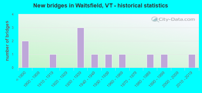
- New bridges - historical statistics
- 2Before 1900
- 11910-1919
- 31930-1939
- 11940-1949
- 11950-1959
- 11960-1969
- 11980-1989
- 11990-1999
- 12010-2019

- Reconstructed bridges - Historical Statistics
- 21960-1969
- 21970-1979
- 01980-1989
- 01990-1999
- 12000-2009


- Bridge Condition - Deck
- 33.3%Very good
- 16.7%Good
- 33.3%Satisfactory
- 16.7%Fair

- Bridge Condition - Superstructure
- 25.0%Very good
- 25.0%Good
- 33.3%Satisfactory
- 16.7%Fair

- Bridge Condition - Substructure
- 25.0%Very good
- 16.7%Good
- 50.0%Satisfactory
- 8.3%Fair

- Bridge Condition - Channel
- 50.0%Very good
- 8.3%Good
- 33.3%Satisfactory
- 8.3%Fair
Find on map >> Show street view
Structure Number: 101216000412161, Location: 0.08 MI TO JCT W VT100 (Lat: 44.189397, Lng: -72.823486), Route carried "on" structure: Other road C2001, Year Built: 1833, Year Reconstructed: 1973, Status: Posted for load, Structure Length: 3.38m (11.09ft), Average Daily Traffic: 1,900 (year 2019), Truck Traffic: 3%, Average Future Daily Traffic: 1,995 (year 2029), Design Load: H 10, Features Intersected: MAD RIVER
Minimum Vertical Clearance: 3.22m (10.56ft), Kilometerpoint: 0.000, Lanes on structure: 1, Owner: Town or Township Highway Agency, Approaching Roadway Width: 9.1m (29.9ft), Material/Design: Wood or Timber, Design/Construction: Arch - Thru, Number Of Spans In Main Unit: 1, Length of Maximum Span: 30.2m (99.1ft), Curb or Sidewalk Widths: Left: 0.0m, Right: 1.3m (4.3ft), Curb-To-Curb Width: 4.5m (14.8ft), Out-to-Out Width: 4.5m (14.8ft)
Condition: Deck: Good, Superstructure: Satisfactory, Substructure: Satisfactory, Channel: Very good, Operating Rating: 2.7 metric tons, Method Used To Determine Operating Rating: Field evaluation and documented engineering judgment, Inventory Rating: 2.7 metric tons, Method Used To Determine Inventory Rating: Field evaluation and documented engineering judgment, Structural Evaluation: High priority of replacement, Deck Geometry: High priority of replacement, Waterway Adequacy: Better than present minimum criteria, Approach Roadway Alignment: Equal to present minimum criteria, Bridge Posting: Required (Relationship of Operating Rating to Maximum Legal Load: 0.1 - 9.9% below), Length Of Structure Improvement: 4.05m (13.29ft), Designated Inspection Frequency: Every 24 months, Inspection Date: July 2020, Bridge Improvement Cost: $656,000, Roadway Improvement Cost: $150,000, Total Project Cost: $806,000 ( Estimate for 2020), Deck Structure Type: Wood or Timber, Wearing Surface/Protective System: Wearing Surface: Wood or Timber
Find on map >> Show street view
Structure Number: 101216002012161, Location: 0.15 MI TO JCT W C3 TH15 (Lat: 44.205672, Lng: -72.792058), Route carried "on" structure: Other road C2003, Year Built: 1872, Year Reconstructed: 1977, Status: Posted for load, Structure Length: 1.58m (5.18ft), Average Daily Traffic: 250 (year 2019), Truck Traffic: 3%, Average Future Daily Traffic: 263 (year 2029), Design Load: H 20, Features Intersected: PINE BROOK
Minimum Vertical Clearance: 3.32m (10.89ft), Kilometerpoint: 0.000, Lanes on structure: 1, Owner: Town or Township Highway Agency, Approaching Roadway Width: 7.0m (23.0ft), Material/Design: Steel, Design/Construction: Girder and Floorbeam System, Number Of Spans In Main Unit: 1, Length of Maximum Span: 14.6m (47.9ft), Curb-To-Curb Width: 4.1m (13.5ft), Out-to-Out Width: 4.3m (14.1ft)
Condition: Deck: Satisfactory, Superstructure: Satisfactory, Substructure: Satisfactory, Channel: Satisfactory, Operating Rating: 20.9 metric tons, Method Used To Determine Operating Rating: Allowable Stress (AS), Inventory Rating: 14.5 metric tons, Method Used To Determine Inventory Rating: Allowable Stress (AS), Structural Evaluation: Meets minimum limits, Deck Geometry: High priority of replacement, Waterway Adequacy: Equal to present minimum criteria, Approach Roadway Alignment: Equal to present minimum criteria, Length Of Structure Improvement: 2.23m (7.32ft), Designated Inspection Frequency: Every 24 months, Critical Feature Inspection Frequency: Every 24 months, Inspection Date: July 2020, Critical Feature Inspection Date: July 2020, Bridge Improvement Cost: $341,000, Roadway Improvement Cost: $150,000, Total Project Cost: $491,000 ( Estimate for 2020), Deck Structure Type: Wood or Timber, Wearing Surface/Protective System: Wearing Surface: Wood or Timber, Deck Protection: Internally Sealed
Find on map >> Show street view
Structure Number: 101216002112161, Location: 0.10 MI E TO JCT W TH16 (Lat: 44.189397, Lng: -72.823486), Route carried "on" structure: Other road C3010, Year Built: 1919, Year Reconstructed: 2011, Status: Posted for load, Structure Length: 0.82m (2.69ft), Average Daily Traffic: 10 (year 2019), Truck Traffic: 1%, Average Future Daily Traffic: 11 (year 2029), Features Intersected: PINE BROOK
Minimum Vertical Clearance: 30+ m (98+ ft), Kilometerpoint: 0.000, Lanes on structure: 1, Owner: Town or Township Highway Agency, Approaching Roadway Width: 5.5m (18.0ft), Skew: 1 degrees, Material/Design: Steel, Design/Construction: Stringer/Multi-beam, Number Of Spans In Main Unit: 1, Length of Maximum Span: 7.6m (24.9ft), Curb-To-Curb Width: 4.1m (13.5ft), Out-to-Out Width: 4.9m (16.1ft)
Condition: Deck: Very good, Superstructure: Good, Substructure: Good, Channel: Satisfactory, Operating Rating: 18.1 metric tons, Method Used To Determine Operating Rating: Allowable Stress (AS), Inventory Rating: 13.6 metric tons, Method Used To Determine Inventory Rating: Allowable Stress (AS), Structural Evaluation: Meets minimum limits, Deck Geometry: Somewhat better than minimum adequacy, Waterway Adequacy: Better than present minimum criteria, Approach Roadway Alignment: Equal to present desirable criteria, Length Of Structure Improvement: 1.49m (4.89ft), Designated Inspection Frequency: Every 24 months, Inspection Date: July 2020, Bridge Improvement Cost: $260,000, Roadway Improvement Cost: $150,000, Total Project Cost: $410,000 ( Estimate for 2020), Deck Structure Type: Wood or Timber, Wearing Surface/Protective System: Wearing Surface: Wood or Timber, Deck Protection: Internally Sealed
Find on map >> Show street view
Structure Number: 101216002212161, Location: 0.1 MI TO JCT W VT100 (Lat: 44.151392, Lng: -72.839867), Route carried "on" structure: Other road C3029, Year Built: 1999, Status: Open, Structure Length: 1.89m (6.20ft), Average Daily Traffic: 180 (year 2019), Truck Traffic: 2%, Average Future Daily Traffic: 189 (year 2029), Design Load: HS 25 or greater, Features Intersected: MAD RIVER
Minimum Vertical Clearance: 30+ m (98+ ft), Kilometerpoint: 0.000, Lanes on structure: 1, Owner: Town or Township Highway Agency, Approaching Roadway Width: 4.9m (16.1ft), Material/Design: Steel, Design/Construction: Truss - Thru, Number Of Spans In Main Unit: 1, Length of Maximum Span: 17.4m (57.1ft), Curb-To-Curb Width: 4.3m (14.1ft), Out-to-Out Width: 4.6m (15.1ft)
Condition: Deck: Very good, Superstructure: Very good, Substructure: Very good, Channel: Very good, Operating Rating: 57.2 metric tons, Method Used To Determine Operating Rating: Allowable Stress (AS), Inventory Rating: 42.6 metric tons, Method Used To Determine Inventory Rating: Allowable Stress (AS), Structural Evaluation: Equal to present desirable criteria, Deck Geometry: High priority of replacement, Waterway Adequacy: Better than present minimum criteria, Approach Roadway Alignment: Meets minimum limits, Length Of Structure Improvement: 1.89m (6.20ft), Designated Inspection Frequency: Every 24 months, Critical Feature Inspection Frequency: Every 24 months, Inspection Date: July 2020, Critical Feature Inspection Date: July 2020, Bridge Improvement Cost: $330,000, Roadway Improvement Cost: $50,000, Total Project Cost: $380,000 ( Estimate for 2020), Deck Structure Type: Wood or Timber, Wearing Surface/Protective System: Wearing Surface: Wood or Timber, Deck Protection: Internally Sealed
Find on map >> Show street view
Structure Number: 101216002412161, Location: 0.1 MI TO JCT W VT100 (Lat: 44.220233, Lng: -72.789092), Route carried "on" structure: Other road C3008, Year Built: 1955, Status: Open, Structure Length: 2.53m (8.30ft), Average Daily Traffic: 300 (year 2019), Truck Traffic: 2%, Average Future Daily Traffic: 315 (year 2029), Features Intersected: MAD RIVER
Minimum Vertical Clearance: 30+ m (98+ ft), Kilometerpoint: 0.000, Lanes on structure: 1, Owner: Town or Township Highway Agency, Approaching Roadway Width: 6.4m (21.0ft), Material/Design: Steel, Design/Construction: Girder and Floorbeam System, Number Of Spans In Main Unit: 1, Length of Maximum Span: 23.8m (78.1ft), Curb or Sidewalk Widths: Left: 0.1m (0.3ft), Right: 0.2m (0.7ft), Curb-To-Curb Width: 4.0m (13.1ft), Out-to-Out Width: 4.0m (13.1ft)
Condition: Deck: Satisfactory, Superstructure: Fair, Substructure: Satisfactory, Channel: Very good, Operating Rating: 23.6 metric tons, Method Used To Determine Operating Rating: Allowable Stress (AS), Inventory Rating: 11.8 metric tons, Method Used To Determine Inventory Rating: Allowable Stress (AS), Structural Evaluation: Meets minimum limits, Deck Geometry: High priority of replacement, Waterway Adequacy: Better than present minimum criteria, Approach Roadway Alignment: Equal to present minimum criteria, Length Of Structure Improvement: 3.29m (10.79ft), Designated Inspection Frequency: Every 24 months, Critical Feature Inspection Frequency: Every 24 months, Inspection Date: July 2020, Critical Feature Inspection Date: July 2020, Bridge Improvement Cost: $470,000, Roadway Improvement Cost: $150,000, Total Project Cost: $620,000 ( Estimate for 2020), Deck Structure Type: Concrete Cast-file-Place
Find on map >> Show street view
Structure Number: 101216002512161, Location: 0.1 MI TO JCT W VT100 (Lat: 44.204222, Lng: -72.807089), Route carried "on" structure: Other road C3015, Year Built: 1983, Status: Open, Structure Length: 3.90m (12.80ft), Average Daily Traffic: 800 (year 2019), Truck Traffic: 2%, Average Future Daily Traffic: 840 (year 2029), Design Load: HS 20, Features Intersected: MAD RIVER
Minimum Vertical Clearance: 30+ m (98+ ft), Kilometerpoint: 0.000, Lanes on structure: 2, Owner: Town or Township Highway Agency, Approaching Roadway Width: 10.4m (34.1ft), Material/Design: Steel continuous, Design/Construction: Stringer/Multi-beam, Number Of Spans In Main Unit: 3, Length of Maximum Span: 27.4m (89.9ft), Curb or Sidewalk Widths: Left: 0.1m (0.3ft), Right: 0.1m (0.3ft), Curb-To-Curb Width: 8.8m (28.9ft), Out-to-Out Width: 9.6m (31.5ft)
Condition: Deck: Very good, Superstructure: Very good, Substructure: Very good, Channel: Very good, Operating Rating: 63.5 metric tons, Method Used To Determine Operating Rating: Allowable Stress (AS), Inventory Rating: 37.2 metric tons, Method Used To Determine Inventory Rating: Allowable Stress (AS), Structural Evaluation: Equal to present desirable criteria, Deck Geometry: Somewhat better than minimum adequacy, Waterway Adequacy: Better than present minimum criteria, Approach Roadway Alignment: Equal to present desirable criteria, Designated Inspection Frequency: Every 24 months, Inspection Date: July 2020, Deck Structure Type: Concrete Cast-file-Place, Wearing Surface/Protective System: Wearing Surface: Bituminous, Membrane: Preformed Fabric
Find on map >> Show street view
Structure Number: 200013017712162, Location: 0.8 MI S JCT. VT.17 (Lat: 44.173078, Lng: -72.832725), Route carried "on" structure: State highway 100, Year Built: 2016, Status: Open, Structure Length: 5.49m (18.01ft), Average Daily Traffic: 5,500 (year 2018), Truck Traffic: 6%, Average Future Daily Traffic: 5,775 (year 2028), Design Load: HL 93, Features Intersected: MAD RIVER
Minimum Vertical Clearance: 30+ m (98+ ft), Kilometerpoint: 207.770, Lanes on structure: 2, Base Highway Network: Yes (Inventory Route: 2300001, Subroute: 1), Owner: State Highway Agency, Approaching Roadway Width: 10.4m (34.1ft), Skew: 5 degrees, Material/Design: Steel, Design/Construction: Stringer/Multi-beam, Number Of Spans In Main Unit: 2, Length of Maximum Span: 52.4m (171.9ft), Curb or Sidewalk Widths: Left: 0.2m (0.7ft), Right: 0.2m (0.7ft), Curb-To-Curb Width: 9.8m (32.2ft), Out-to-Out Width: 10.7m (35.1ft)
Condition: Deck: Very good, Superstructure: Very good, Substructure: Very good, Channel: Very good, Operating Rating: 74.4 metric tons, Method Used To Determine Operating Rating: Load and Resistance Factor (LRFR), Inventory Rating: 50.8 metric tons, Method Used To Determine Inventory Rating: Load and Resistance Factor (LRFR), Structural Evaluation: Equal to present desirable criteria, Deck Geometry: Meets minimum limits, Waterway Adequacy: Better than present minimum criteria, Approach Roadway Alignment: Equal to present desirable criteria, Designated Inspection Frequency: Every 24 months, Inspection Date: August 2021, Deck Structure Type: Concrete Cast-file-Place, Wearing Surface/Protective System: Wearing Surface: Bituminous, Membrane: Preformed Fabric, Deck Protection: Other Coated Reinforcing
Find on map >> Show street view
Structure Number: 200013017812162, Location: 0.3 MI S JCT. VT.17 (Lat: 44.178386, Lng: -72.836217), Route carried "on" structure: State highway 100, Year Built: 1938, Year Reconstructed: 1973, Status: Open, Structure Length: 2.10m (6.89ft), Average Daily Traffic: 5,500 (year 2018), Truck Traffic: 9%, Average Future Daily Traffic: 5,775 (year 2028), Design Load: H 15, Features Intersected: MILL BROOK
Minimum Vertical Clearance: 30+ m (98+ ft), Kilometerpoint: 208.446, Lanes on structure: 2, Base Highway Network: Yes (Inventory Route: 2300001, Subroute: 1), Owner: State Highway Agency, Approaching Roadway Width: 9.8m (32.2ft), Material/Design: Steel, Design/Construction: Stringer/Multi-beam, Number Of Spans In Main Unit: 1, Length of Maximum Span: 20.4m (66.9ft), Curb or Sidewalk Widths: Left: 0.2m (0.7ft), Right: 0.2m (0.7ft), Curb-To-Curb Width: 9.2m (30.2ft), Out-to-Out Width: 9.9m (32.5ft)
Condition: Deck: Satisfactory, Superstructure: Good, Substructure: Satisfactory, Channel: Satisfactory, Operating Rating: 34.5 metric tons, Method Used To Determine Operating Rating: Load Factor (LF), Inventory Rating: 20.0 metric tons, Method Used To Determine Inventory Rating: Load Factor (LF), Structural Evaluation: Somewhat better than minimum adequacy, Deck Geometry: High priority of corrective action, Waterway Adequacy: Equal to present minimum criteria, Approach Roadway Alignment: Equal to present desirable criteria, Length Of Structure Improvement: 2.10m (6.89ft), Designated Inspection Frequency: Every 24 months, Inspection Date: August 2021, Bridge Improvement Cost: $785,000, Roadway Improvement Cost: $50,000, Total Project Cost: $835,000 ( Estimate for 2020), Deck Structure Type: Concrete Cast-file-Place, Wearing Surface/Protective System: Wearing Surface: Bituminous, Membrane: Preformed Fabric
Find on map >> Show street view
Structure Number: 200013018112162, Location: 2.5 MI N JCT. VT.17 (Lat: 44.204233, Lng: -72.808947), Route carried "on" structure: State highway 100, Year Built: 1940, Status: Open, Structure Length: 0.76m (2.49ft), Average Daily Traffic: 6,400 (year 2018), Truck Traffic: 9%, Average Future Daily Traffic: 6,720 (year 2028), Design Load: H 15, Features Intersected: BROOK
Minimum Vertical Clearance: 30+ m (98+ ft), Kilometerpoint: 212.549, Lanes on structure: 2, Base Highway Network: Yes (Inventory Route: 2300001, Subroute: 1), Owner: State Highway Agency, Approaching Roadway Width: 7.3m (24.0ft), Material/Design: Concrete, Design/Construction: Slab, Number Of Spans In Main Unit: 1, Length of Maximum Span: 7.0m (23.0ft), Curb-To-Curb Width: 8.0m (26.2ft), Out-to-Out Width: 8.3m (27.2ft)
Condition: Deck: Fair, Superstructure: Fair, Substructure: Satisfactory, Channel: Fair, Operating Rating: 42.6 metric tons, Method Used To Determine Operating Rating: Load Factor (LF), Inventory Rating: 25.4 metric tons, Method Used To Determine Inventory Rating: Load Factor (LF), Structural Evaluation: Somewhat better than minimum adequacy, Deck Geometry: High priority of replacement, Waterway Adequacy: Somewhat better than minimum adequacy, Approach Roadway Alignment: Equal to present desirable criteria, Length Of Structure Improvement: 1.37m (4.49ft), Designated Inspection Frequency: Every 24 months, Inspection Date: August 2021, Bridge Improvement Cost: $459,000, Roadway Improvement Cost: $150,000, Total Project Cost: $609,000 ( Estimate for 2020), Deck Structure Type: Concrete Cast-file-Place, Wearing Surface/Protective System: Wearing Surface: Bituminous
Find on map >> Show street view
Structure Number: 200013018612162, Location: 0.9 MI S JCT. VT.100B (Lat: 44.228803, Lng: -72.783997), Route carried "on" structure: State highway 100, Year Built: 1938, Year Reconstructed: 1977, Status: Open, Structure Length: 2.56m (8.40ft), Average Daily Traffic: 6,400 (year 2018), Truck Traffic: 9%, Average Future Daily Traffic: 6,720 (year 2028), Design Load: H 15, Features Intersected: SHEPARD BROOK
Minimum Vertical Clearance: 30+ m (98+ ft), Kilometerpoint: 216.105, Lanes on structure: 2, Base Highway Network: Yes (Inventory Route: 2300001, Subroute: 1), Owner: State Highway Agency, Approaching Roadway Width: 7.9m (25.9ft), Skew: 1 degrees, Material/Design: Steel, Design/Construction: Stringer/Multi-beam, Number Of Spans In Main Unit: 1, Length of Maximum Span: 25.0m (82.0ft), Curb-To-Curb Width: 8.4m (27.6ft), Out-to-Out Width: 8.8m (28.9ft)
Condition: Deck: Fair, Superstructure: Satisfactory, Substructure: Satisfactory, Channel: Good, Operating Rating: 40.8 metric tons, Method Used To Determine Operating Rating: Load Factor (LF), Inventory Rating: 24.5 metric tons, Method Used To Determine Inventory Rating: Load Factor (LF), Structural Evaluation: Equal to present minimum criteria, Deck Geometry: High priority of replacement, Waterway Adequacy: Better than present minimum criteria, Approach Roadway Alignment: Equal to present minimum criteria, Length Of Structure Improvement: 2.56m (8.40ft), Designated Inspection Frequency: Every 24 months, Inspection Date: August 2021, Bridge Improvement Cost: $853,000, Roadway Improvement Cost: $50,000, Total Project Cost: $903,000 ( Estimate for 2020), Deck Structure Type: Concrete Cast-file-Place, Wearing Surface/Protective System: Wearing Surface: Bituminous, Membrane: Preformed Fabric
Find on map >> Show street view
Structure Number: 200200001301032, Location: 1.0 MI E JCT. VT.116 N (Lat: 44.161233, Lng: -73.030086), Route carried "on" structure: State highway 17, Year Built: 1964, Status: Open, Structure Length: 1.01m (3.31ft), Average Daily Traffic: 1,500 (year 2018), Truck Traffic: 6%, Average Future Daily Traffic: 1,575 (year 2028), Design Load: H 20, Features Intersected: BALDWIN CREEK
Minimum Vertical Clearance: 30+ m (98+ ft), Kilometerpoint: 0.000, Lanes on structure: 2, Owner: State Highway Agency, Approaching Roadway Width: 8.2m (26.9ft), Skew: 4 degrees, Material/Design: Concrete, Design/Construction: Slab, Number Of Spans In Main Unit: 1, Length of Maximum Span: 8.5m (27.9ft), Curb-To-Curb Width: 8.7m (28.5ft), Out-to-Out Width: 10.4m (34.1ft)
Condition: Deck: Good, Superstructure: Good, Substructure: Good, Channel: Satisfactory, Operating Rating: 74.4 metric tons, Method Used To Determine Operating Rating: Allowable Stress (AS), Inventory Rating: 40.8 metric tons, Method Used To Determine Inventory Rating: Allowable Stress (AS), Structural Evaluation: Better than present minimum criteria, Deck Geometry: Somewhat better than minimum adequacy, Waterway Adequacy: Equal to present minimum criteria, Approach Roadway Alignment: Equal to present desirable criteria, Designated Inspection Frequency: Every 24 months, Inspection Date: May 2021, Deck Structure Type: Concrete Cast-file-Place, Wearing Surface/Protective System: Wearing Surface: Bituminous, Membrane: Preformed Fabric
Find on map >> Show street view
Structure Number: 200200003812162, Location: 0.1 MI W JCT. VT.100 (Lat: 44.180775, Lng: -72.842533), Route carried "on" structure: State highway 17, Year Built: 1939, Status: Open, Structure Length: 1.95m (6.40ft), Average Daily Traffic: 2,800 (year 2018), Truck Traffic: 6%, Average Future Daily Traffic: 2,940 (year 2028), Design Load: H 15, Features Intersected: MILL BROOK
Minimum Vertical Clearance: 30+ m (98+ ft), Kilometerpoint: 0.000, Lanes on structure: 2, Owner: State Highway Agency, Approaching Roadway Width: 7.3m (24.0ft), Material/Design: Steel, Design/Construction: Stringer/Multi-beam, Number Of Spans In Main Unit: 1, Length of Maximum Span: 18.0m (59.1ft), Curb-To-Curb Width: 7.7m (25.3ft), Out-to-Out Width: 7.8m (25.6ft)
Condition: Deck: Satisfactory, Superstructure: Satisfactory, Substructure: Fair, Channel: Very good, Operating Rating: 56.2 metric tons, Method Used To Determine Operating Rating: Load Factor (LF), Inventory Rating: 33.6 metric tons, Method Used To Determine Inventory Rating: Load Factor (LF), Structural Evaluation: Somewhat better than minimum adequacy, Deck Geometry: High priority of replacement, Waterway Adequacy: Better than present minimum criteria, Approach Roadway Alignment: High priority of corrective action, Length Of Structure Improvement: 1.95m (6.40ft), Designated Inspection Frequency: Every 24 months, Inspection Date: July 2021, Bridge Improvement Cost: $576,000, Roadway Improvement Cost: $50,000, Total Project Cost: $626,000 ( Estimate for 2020), Deck Structure Type: Concrete Cast-file-Place