Bridge Statistics for Wadsworth, Nevada (NV)
Condition, Traffic, Stress, Structural Evaluation, Project Costs
- National Bridge Inventory (NBI) Statistics
- 10Number of bridges
- 131ft / 39.9mTotal length
- 67,960Total average daily traffic
- 16,160Total average daily truck traffic
- National Bridge Inventory (NBI) Registered Bridges for Wadsworth
- No street view available for this location
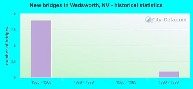
- New bridges - historical statistics
- 91960-1969
- 11990-1999


- Bridge Condition - Deck
- 33.3%Good
- 50.0%Satisfactory
- 16.7%Fair

- Bridge Condition - Superstructure
- 83.3%Good
- 16.7%Satisfactory

- Bridge Condition - Substructure
- 66.7%Good
- 33.3%Fair

- Bridge Condition - Channel
- 50.0%Good
- 50.0%Satisfactory
Find on map >> Show street view
Structure Number: B 16, Location: WADSWORTH (Lat: 39.632025, Lng: -119.283028), Route carried "on" structure: State highway 427, Year Built: 1993, Status: Open, Structure Length: 8.23m (27.00ft), Average Daily Traffic: 2,600 (year 2017), Truck Traffic: 12%, Average Future Daily Traffic: 4,500 (year 2040), Design Load: HS 20+Mod, Features Intersected: TRUCKEE RVR
Minimum Vertical Clearance: 30+ m (98+ ft), Kilometerpoint: 3.109, Lanes on structure: 2, Owner: State Highway Agency, Approaching Roadway Width: 7.9m (25.9ft), Material/Design: Prestressed concrete continuous, Design/Construction: Box Beam or Girders - Multiple, Number Of Spans In Main Unit: 2, Length of Maximum Span: 40.8m (133.9ft), Curb or Sidewalk Widths: Left: 0.0m, Right: 1.5m (4.9ft), Curb-To-Curb Width: 13.4m (44.0ft), Out-to-Out Width: 15.7m (51.5ft)
Condition: Deck: Satisfactory, Superstructure: Good, Substructure: Good, Channel: Good, Inventory Rating: 48.6 metric tons, Method Used To Determine Inventory Rating: Load Factor (LF), Structural Evaluation: Better than present minimum criteria, Deck Geometry: Better than present minimum criteria, Waterway Adequacy: Superior to present desirable criteria, Approach Roadway Alignment: Equal to present desirable criteria, Designated Inspection Frequency: Every 24 months, Inspection Date: May 2021, Deck Structure Type: Concrete Cast-file-Place, Wearing Surface/Protective System: Wearing Surface: Monolithic Concrete, Deck Protection: Epoxy Coated Reinforcing
Find on map >> Show street view
Structure Number: B 716W, Location: WEST OF FERNLEY (Lat: 39.617947, Lng: -119.293489), Route carried "on" structure: Interstate 80, Year Built: 1961, Status: Open, Structure Length: 9.54m (31.30ft), Average Daily Traffic: 13,500 (year 2017), Truck Traffic: 26%, Average Future Daily Traffic: 33,506 (year 2040), Design Load: HS 20+Mod, Features Intersected: TRUCKEE RVR
Minimum Vertical Clearance: 30+ m (98+ ft), Kilometerpoint: 71.897, Lanes on structure: 2, Base Highway Network: Yes, Owner: State Highway Agency, Approaching Roadway Width: 11.6m (38.1ft), Skew: 3 degrees, Material/Design: Prestressed concrete, Design/Construction: Tee Beam, Number Of Spans In Main Unit: 4, Length of Maximum Span: 23.8m (78.1ft), Curb-To-Curb Width: 11.6m (38.1ft), Out-to-Out Width: 13.1m (43.0ft)
Condition: Deck: Fair, Superstructure: Satisfactory, Substructure: Good, Channel: Satisfactory, Operating Rating: 41.1 metric tons, Method Used To Determine Operating Rating: Load Factor (LF), Inventory Rating: 24.8 metric tons, Method Used To Determine Inventory Rating: Load Factor (LF), Structural Evaluation: Equal to present minimum criteria, Deck Geometry: Equal to present minimum criteria, Waterway Adequacy: Superior to present desirable criteria, Approach Roadway Alignment: Equal to present desirable criteria, Designated Inspection Frequency: Every 24 months, Underwater Inspection Frequency: Every 48 months, Inspection Date: May 2021, Underwater Inspection Date: August 2019, Deck Structure Type: Concrete Cast-file-Place, Wearing Surface/Protective System: Wearing Surface: Bituminous, Membrane: Preformed Fabric
Find on map >> Show street view
Structure Number: I 700E, Location: WEST OF WADSWORTH (Lat: 39.615892, Lng: -119.308967), Route carried "on" structure: Interstate 80, Year Built: 1963, Status: Open, Structure Length: 4.08m (13.39ft), Average Daily Traffic: 13,500 (year 2017), Truck Traffic: 26%, Average Future Daily Traffic: 33,506 (year 2040), Design Load: HS 20+Mod, Features Intersected: SR427 OLD US 40
Minimum Vertical Clearance: 30+ m (98+ ft), Kilometerpoint: 70.599, Lanes on structure: 2, Lanes under structure: 2, Base Highway Network: Yes, Owner: State Highway Agency, Approaching Roadway Width: 11.6m (38.1ft), Skew: 3 degrees, Material/Design: Concrete continuous, Design/Construction: Box Beam or Girders - Single/Spread, Number Of Spans In Main Unit: 3, Length of Maximum Span: 15.8m (51.8ft), Curb-To-Curb Width: 11.6m (38.1ft), Out-to-Out Width: 13.1m (43.0ft)
Condition: Deck: Good, Superstructure: Good, Substructure: Good, Operating Rating: 63.9 metric tons, Method Used To Determine Operating Rating: Load Factor (LF), Inventory Rating: 38.2 metric tons, Method Used To Determine Inventory Rating: Load Factor (LF), Structural Evaluation: Better than present minimum criteria, Deck Geometry: Equal to present minimum criteria, Underclear: Meets minimum limits, Approach Roadway Alignment: Equal to present desirable criteria, Designated Inspection Frequency: Every 48 months, Inspection Date: May 2021, Deck Structure Type: Concrete Cast-file-Place, Wearing Surface/Protective System: Wearing Surface: Bituminous, Membrane: Other
Find on map >> Show street view
Structure Number: I 700W, Location: WEST OF WADSWORTH (Lat: 39.616297, Lng: -119.308919), Route carried "on" structure: Interstate 80, Year Built: 1963, Status: Open, Structure Length: 4.08m (13.39ft), Average Daily Traffic: 13,500 (year 2017), Truck Traffic: 26%, Average Future Daily Traffic: 33,506 (year 2040), Design Load: HS 20+Mod, Features Intersected: SR427 OLD US 40
Minimum Vertical Clearance: 30+ m (98+ ft), Kilometerpoint: 70.599, Lanes on structure: 2, Lanes under structure: 2, Base Highway Network: Yes, Owner: State Highway Agency, Approaching Roadway Width: 11.6m (38.1ft), Skew: 3 degrees, Material/Design: Concrete continuous, Design/Construction: Box Beam or Girders - Single/Spread, Number Of Spans In Main Unit: 3, Length of Maximum Span: 18.3m (60.0ft), Curb-To-Curb Width: 11.6m (38.1ft), Out-to-Out Width: 13.1m (43.0ft)
Condition: Deck: Good, Superstructure: Good, Substructure: Good, Operating Rating: 63.9 metric tons, Method Used To Determine Operating Rating: Load Factor (LF), Inventory Rating: 38.2 metric tons, Method Used To Determine Inventory Rating: Load Factor (LF), Structural Evaluation: Better than present minimum criteria, Deck Geometry: Equal to present minimum criteria, Underclear: Meets minimum limits, Approach Roadway Alignment: Equal to present desirable criteria, Designated Inspection Frequency: Every 48 months, Inspection Date: May 2021, Deck Structure Type: Concrete Cast-file-Place, Wearing Surface/Protective System: Wearing Surface: Bituminous, Membrane: Other
Find on map >> Show street view
Structure Number: I 717E, Location: WADSWORTH - FERNLEY (Lat: 39.615978, Lng: -119.265092), Route carried "on" structure: Interstate 80, Year Built: 1963, Status: Open, Structure Length: 6.98m (22.90ft), Average Daily Traffic: 5,500 (year 2017), Truck Traffic: 36%, Average Future Daily Traffic: 13,650 (year 2040), Design Load: HS 20+Mod, Features Intersected: SR427 MAIN ST
Minimum Vertical Clearance: 30+ m (98+ ft), Kilometerpoint: 74.411, Lanes on structure: 2, Lanes under structure: 4, Base Highway Network: Yes, Owner: State Highway Agency, Approaching Roadway Width: 11.6m (38.1ft), Skew: 1 degrees, Material/Design: Prestressed concrete, Design/Construction: Stringer/Multi-beam, Number Of Spans In Main Unit: 4, Length of Maximum Span: 18.3m (60.0ft), Curb or Sidewalk Widths: Left: 0.5m (1.6ft), Right: 0.5m (1.6ft), Curb-To-Curb Width: 11.6m (38.1ft), Out-to-Out Width: 13.1m (43.0ft)
Condition: Deck: Satisfactory, Superstructure: Good, Substructure: Fair, Operating Rating: 49.9 metric tons, Method Used To Determine Operating Rating: Load Factor (LF), Inventory Rating: 30.0 metric tons, Method Used To Determine Inventory Rating: Load Factor (LF), Structural Evaluation: Somewhat better than minimum adequacy, Deck Geometry: Equal to present minimum criteria, Underclear: Meets minimum limits, Approach Roadway Alignment: Equal to present desirable criteria, Designated Inspection Frequency: Every 24 months, Inspection Date: May 2021, Deck Structure Type: Concrete Cast-file-Place, Wearing Surface/Protective System: Wearing Surface: Bituminous
Find on map >> Show street view
Structure Number: I 717W, Location: WADSWORTH - FERNLEY (Lat: 39.616344, Lng: -119.265097), Route carried "on" structure: Interstate 80, Year Built: 1963, Status: Open, Structure Length: 6.98m (22.90ft), Average Daily Traffic: 5,500 (year 2017), Truck Traffic: 36%, Average Future Daily Traffic: 13,650 (year 2040), Design Load: HS 20+Mod, Features Intersected: SR427 MAIN ST
Minimum Vertical Clearance: 30+ m (98+ ft), Kilometerpoint: 74.411, Lanes on structure: 2, Lanes under structure: 4, Base Highway Network: Yes, Owner: State Highway Agency, Approaching Roadway Width: 11.6m (38.1ft), Skew: 1 degrees, Material/Design: Prestressed concrete, Design/Construction: Stringer/Multi-beam, Number Of Spans In Main Unit: 4, Length of Maximum Span: 18.3m (60.0ft), Curb or Sidewalk Widths: Left: 0.5m (1.6ft), Right: 0.5m (1.6ft), Curb-To-Curb Width: 11.6m (38.1ft), Out-to-Out Width: 13.1m (43.0ft)
Condition: Deck: Satisfactory, Superstructure: Good, Substructure: Fair, Operating Rating: 49.9 metric tons, Method Used To Determine Operating Rating: Load Factor (LF), Inventory Rating: 30.0 metric tons, Method Used To Determine Inventory Rating: Load Factor (LF), Structural Evaluation: Somewhat better than minimum adequacy, Deck Geometry: Equal to present minimum criteria, Underclear: Meets minimum limits, Approach Roadway Alignment: Equal to present desirable criteria, Designated Inspection Frequency: Every 24 months, Inspection Date: May 2021, Deck Structure Type: Concrete Cast-file-Place, Wearing Surface/Protective System: Wearing Surface: Bituminous
Find on map >> Show street view
Structure Number: I 700E, Location: WEST OF WADSWORTH (Lat: 39.615892, Lng: -119.308967), Route carried "under" structure: State highway 427, Year Built: 1963, Structure Length: 0. m, Average Daily Traffic: 1,650 (year 2009), Truck Traffic: 6%, Features Intersected: SR427 OLD US 40, Facility Carried by Structure: I 80E
Minimum Vertical Clearance: 4.88m (16.01ft), Kilometerpoint: 70.599, Lanes on structure: 2, Lanes under structure: 2, Material/Design: Concrete continuous, Design/Construction: Box Beam or Girders - Single/Spread, Length of Maximum Span: 15.8m (51.8ft)
Find on map >> Show street view
Structure Number: I 700W, Location: WEST OF WADSWORTH (Lat: 39.616297, Lng: -119.308919), Route carried "under" structure: State highway 427, Year Built: 1963, Structure Length: 0. m, Average Daily Traffic: 1,650 (year 2009), Truck Traffic: 6%, Features Intersected: SR427 OLD US 40, Facility Carried by Structure: I 80W
Minimum Vertical Clearance: 4.88m (16.01ft), Kilometerpoint: 70.599, Lanes on structure: 2, Lanes under structure: 2, Material/Design: Concrete continuous, Design/Construction: Box Beam or Girders - Single/Spread, Length of Maximum Span: 18.3m (60.0ft)
Find on map >> Show street view
Structure Number: I 717E, Location: WADSWORTH - FERNLEY (Lat: 39.615978, Lng: -119.265092), Route carried "under" structure: State highway 427, Year Built: 1963, Structure Length: 0. m, Average Daily Traffic: 5,280 (year 2009), Truck Traffic: 11%, Features Intersected: SR427 MAIN ST, Facility Carried by Structure: I 80E
Minimum Vertical Clearance: 5.70m (18.70ft), Kilometerpoint: 74.411, Lanes on structure: 2, Lanes under structure: 4, Material/Design: Prestressed concrete, Design/Construction: Stringer/Multi-beam, Length of Maximum Span: 18.3m (60.0ft)
Find on map >> Show street view
Structure Number: I 717W, Location: WADSWORTH - FERNLEY (Lat: 39.616344, Lng: -119.265097), Route carried "under" structure: State highway 427, Year Built: 1963, Structure Length: 0. m, Average Daily Traffic: 5,280 (year 2009), Truck Traffic: 11%, Features Intersected: SR427 MAIN ST, Facility Carried by Structure: I 80W
Minimum Vertical Clearance: 5.70m (18.70ft), Kilometerpoint: 74.411, Lanes on structure: 2, Lanes under structure: 4, Material/Design: Prestressed concrete, Design/Construction: Stringer/Multi-beam, Length of Maximum Span: 18.3m (60.0ft)