Bridge Statistics for Wacousta, Michigan (MI)
Condition, Traffic, Stress, Structural Evaluation, Project Costs
- National Bridge Inventory (NBI) Statistics
- 25Number of bridges
- 262ft / 79.9mTotal length
- 328,932Total average daily traffic
- 45,929Total average daily truck traffic
- National Bridge Inventory (NBI) Registered Bridges for Wacousta
- No street view available for this location
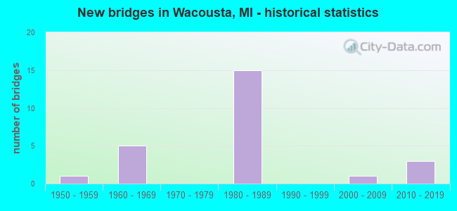
- New bridges - historical statistics
- 11950-1959
- 51960-1969
- 151980-1989
- 12000-2009
- 32010-2019


- Bridge Condition - Deck
- 8.3%Very good
- 41.7%Good
- 33.3%Satisfactory
- 8.3%Fair
- 8.3%Critical

- Bridge Condition - Superstructure
- 8.3%Very good
- 16.7%Good
- 33.3%Satisfactory
- 33.3%Fair
- 8.3%Critical

- Bridge Condition - Substructure
- 16.7%Very good
- 33.3%Good
- 41.7%Satisfactory
- 8.3%Fair

- Bridge Condition - Channel
- 16.7%Very good
- 33.3%Good
- 33.3%Satisfactory
- 16.7%Fair
Find on map >> Show street view
Structure Number: 1791, Location: AT M-100 (Lat: 42.800322, Lng: -84.739411), Route carried "on" structure: State highway 100, Year Built: 2011, Status: Open, Structure Length: 6.44m (21.13ft), Average Daily Traffic: 6,725 (year 2010), Truck Traffic: 7%, Average Future Daily Traffic: 7,800 (year 2030), Design Load: HL 93, Features Intersected: I-96
Minimum Vertical Clearance: 30.48m (100.00ft), Kilometerpoint: 3.307, Lanes on structure: 3, Lanes under structure: 4, Base Highway Network: Yes (Inventory Route: 20, Subroute: 1), Owner: State Highway Agency, Approaching Roadway Width: 17.1m (56.1ft), Skew: 1 degrees, Material/Design: Prestressed concrete, Design/Construction: Box Beam or Girders - Single/Spread, Number Of Spans In Main Unit: 2, Length of Maximum Span: 31.5m (103.3ft), Curb-To-Curb Width: 17.1m (56.1ft), Out-to-Out Width: 18.1m (59.4ft)
Condition: Deck: Good, Superstructure: Satisfactory, Substructure: Satisfactory, Operating Rating: 96.1 metric tons, Method Used To Determine Operating Rating: Load Factor (LF), Inventory Rating: 41.8 metric tons, Method Used To Determine Inventory Rating: Load Factor (LF), Structural Evaluation: Equal to present minimum criteria, Deck Geometry: Superior to present desirable criteria, Underclear: Somewhat better than minimum adequacy, Approach Roadway Alignment: Equal to present desirable criteria, Designated Inspection Frequency: Every 24 months, Inspection Date: April 2020, Deck Structure Type: Concrete Cast-file-Place, Wearing Surface/Protective System: Wearing Surface: Monolithic Concrete, Deck Protection: Epoxy Coated Reinforcing
Find on map >> Show street view
Structure Number: 1792, Location: 2.0 MI E OF M-100 (Lat: 42.798258, Lng: -84.700933), Route carried "on" structure: County highway , Year Built: 1962, Year Reconstructed: 2009, Status: Open, Structure Length: 6.52m (21.39ft), Average Daily Traffic: 1,250 (year 0000), Truck Traffic: 3%, Average Future Daily Traffic: 4,000 (year 2015), Design Load: H 15, Features Intersected: I-96, Facility Carried by Structure: WACOUSTA RD
Minimum Vertical Clearance: 30.48m (100.00ft), Kilometerpoint: 3.146, Lanes on structure: 2, Lanes under structure: 5, Owner: State Highway Agency, Approaching Roadway Width: 10.3m (33.8ft), Material/Design: Prestressed concrete, Design/Construction: Stringer/Multi-beam, Number Of Spans In Main Unit: 4, Length of Maximum Span: 21.2m (69.6ft), Curb-To-Curb Width: 8.8m (28.9ft), Out-to-Out Width: 10.0m (32.8ft)
Condition: Deck: Good, Superstructure: Satisfactory, Substructure: Satisfactory, Operating Rating: 59.3 metric tons, Method Used To Determine Operating Rating: Load Factor (LF) rating reported by rating factor (RF) method using MS18 loading, Inventory Rating: 33.7 metric tons, Method Used To Determine Inventory Rating: Load Factor (LF) rating reported by rating factor (RF) method using MS18 loading, Structural Evaluation: Equal to present minimum criteria, Deck Geometry: Somewhat better than minimum adequacy, Underclear: Meets minimum limits, Approach Roadway Alignment: Equal to present minimum criteria, Designated Inspection Frequency: Every 24 months, Inspection Date: April 2020, Deck Structure Type: Concrete Cast-file-Place, Wearing Surface/Protective System: Wearing Surface: Latex Concrete
Find on map >> Show street view
Structure Number: 1794, Location: AT I-96 BL (Lat: 42.785311, Lng: -84.671678), Route carried "on" structure: Interstate 96, Year Built: 1962, Year Reconstructed: 2009, Status: Open, Structure Length: 7.10m (23.29ft), Average Daily Traffic: 18,210 (year 2007), Truck Traffic: 18%, Average Future Daily Traffic: 16,114 (year 2018), Design Load: HS 20+Mod, Features Intersected: I-96 BL
Minimum Vertical Clearance: 30.48m (100.00ft), Kilometerpoint: 14.650, Lanes on structure: 3, Lanes under structure: 4, Base Highway Network: Yes (Inventory Route: 20, Subroute: 2), Owner: State Highway Agency, Approaching Roadway Width: 18.9m (62.0ft), Skew: 13 degrees, Material/Design: Steel, Design/Construction: Stringer/Multi-beam, Number Of Spans In Main Unit: 4, Length of Maximum Span: 21.2m (69.6ft), Curb-To-Curb Width: 19.1m (62.7ft), Out-to-Out Width: 20.3m (66.6ft)
Condition: Deck: Satisfactory, Superstructure: Fair, Substructure: Satisfactory, Operating Rating: 69.7 metric tons, Method Used To Determine Operating Rating: Load Factor (LF) rating reported by rating factor (RF) method using MS18 loading, Inventory Rating: 41.8 metric tons, Method Used To Determine Inventory Rating: Load Factor (LF) rating reported by rating factor (RF) method using MS18 loading, Structural Evaluation: Somewhat better than minimum adequacy, Deck Geometry: Superior to present desirable criteria, Underclear: Equal to present minimum criteria, Approach Roadway Alignment: Equal to present desirable criteria, Designated Inspection Frequency: Every 24 months, Inspection Date: April 2020, Deck Structure Type: Concrete Cast-file-Place, Wearing Surface/Protective System: Wearing Surface: Latex Concrete
Find on map >> Show street view
Structure Number: 1862, Location: 0.2 MI WEST OF LOWELL RD (Lat: 42.797553, Lng: -84.644006), Route carried "on" structure: Interstate 69, Year Built: 1980, Status: Open, Structure Length: 0.83m (2.72ft), Average Daily Traffic: 28,930 (year 2007), Truck Traffic: 20%, Average Future Daily Traffic: 41,737 (year 2018), Design Load: HS 20+Mod, Features Intersected: WATSON & SUMMERS DRAIN
Minimum Vertical Clearance: 30.48m (100.00ft), Kilometerpoint: 3.381, Lanes on structure: 4, Base Highway Network: Yes (Inventory Route: 36, Subroute: 5), Owner: State Highway Agency, Approaching Roadway Width: 21.9m (71.9ft), Material/Design: Concrete, Design/Construction: Culvert, Number Of Spans In Main Unit: 2, Length of Maximum Span: 3.7m (12.1ft), Out-to-Out Width: 71.6m (234.9ft)
Condition: Channel: Fair, Culverts: Satisfactory, Operating Rating: 97.2 metric tons, Method Used To Determine Operating Rating: Load Factor (LF) rating reported by rating factor (RF) method using MS18 loading, Inventory Rating: 97.2 metric tons, Method Used To Determine Inventory Rating: Load Factor (LF) rating reported by rating factor (RF) method using MS18 loading, Structural Evaluation: Equal to present minimum criteria, Waterway Adequacy: Equal to present minimum criteria, Approach Roadway Alignment: Equal to present desirable criteria, Designated Inspection Frequency: Every 24 months, Inspection Date: April 2020
Find on map >> Show street view
Structure Number: 1875, Location: 5 MI NW OF LANSING (Lat: 42.784047, Lng: -84.665278), Route carried "on" structure: Interstate 69, Year Built: 1981, Status: Open, Structure Length: 6.82m (22.38ft), Average Daily Traffic: 10,507 (year 2007), Truck Traffic: 16%, Average Future Daily Traffic: 23,290 (year 2018), Design Load: HS 25 or greater, Features Intersected: I-96BL GRAND RIVER AVE
Minimum Vertical Clearance: 30.48m (100.00ft), Kilometerpoint: 1.761, Lanes on structure: 2, Lanes under structure: 5, Base Highway Network: Yes (Inventory Route: 36, Subroute: 2), Owner: State Highway Agency, Approaching Roadway Width: 14.0m (45.9ft), Skew: 2 degrees, Material/Design: Steel, Design/Construction: Stringer/Multi-beam, Number Of Spans In Main Unit: 3, Length of Maximum Span: 46.0m (150.9ft), Curb-To-Curb Width: 13.3m (43.6ft), Out-to-Out Width: 13.9m (45.6ft)
Condition: Deck: Satisfactory, Superstructure: Satisfactory, Substructure: Good, Operating Rating: 97.2 metric tons, Method Used To Determine Operating Rating: Load Factor (LF) rating reported by rating factor (RF) method using MS18 loading, Inventory Rating: 57.7 metric tons, Method Used To Determine Inventory Rating: Load Factor (LF) rating reported by rating factor (RF) method using MS18 loading, Structural Evaluation: Equal to present minimum criteria, Deck Geometry: Superior to present desirable criteria, Underclear: Equal to present minimum criteria, Approach Roadway Alignment: Meets minimum limits, Designated Inspection Frequency: Every 24 months, Other Special Inspection Frequency: Every 4 months, Inspection Date: April 2020, Other Special Inspection Date: December 2021, Deck Structure Type: Concrete Cast-file-Place, Wearing Surface/Protective System: Wearing Surface: Epoxy Overlay, Membrane: Epoxy, Deck Protection: Epoxy Coated Reinforcing
Find on map >> Show street view
Structure Number: 1876, Location: 5 MI NW OF LANSING (Lat: 42.783950, Lng: -84.664764), Route carried "on" structure: Interstate 69, Year Built: 1981, Status: Open, Structure Length: 6.92m (22.70ft), Average Daily Traffic: 10,507 (year 2007), Truck Traffic: 16%, Average Future Daily Traffic: 23,290 (year 2018), Design Load: HS 25 or greater, Features Intersected: I-96BL GRAND RIVER AVE
Minimum Vertical Clearance: 30.48m (100.00ft), Kilometerpoint: 1.152, Lanes on structure: 2, Lanes under structure: 5, Base Highway Network: Yes (Inventory Route: 36, Subroute: 5), Owner: State Highway Agency, Approaching Roadway Width: 14.0m (45.9ft), Skew: 2 degrees, Material/Design: Steel, Design/Construction: Stringer/Multi-beam, Number Of Spans In Main Unit: 3, Length of Maximum Span: 46.0m (150.9ft), Curb-To-Curb Width: 13.3m (43.6ft), Out-to-Out Width: 13.9m (45.6ft)
Condition: Deck: Fair, Superstructure: Fair, Substructure: Satisfactory, Operating Rating: 97.2 metric tons, Method Used To Determine Operating Rating: Load Factor (LF) rating reported by rating factor (RF) method using MS18 loading, Inventory Rating: 56.4 metric tons, Method Used To Determine Inventory Rating: Load Factor (LF) rating reported by rating factor (RF) method using MS18 loading, Structural Evaluation: Somewhat better than minimum adequacy, Deck Geometry: Superior to present desirable criteria, Underclear: Equal to present minimum criteria, Approach Roadway Alignment: Equal to present desirable criteria, Designated Inspection Frequency: Every 24 months, Other Special Inspection Frequency: Every 4 months, Inspection Date: April 2020, Other Special Inspection Date: December 2021, Deck Structure Type: Concrete Cast-file-Place, Wearing Surface/Protective System: Wearing Surface: Epoxy Overlay, Deck Protection: Epoxy Coated Reinforcing
Find on map >> Show street view
Structure Number: 1877, Location: 7 MI NW OF LANSING (Lat: 42.779736, Lng: -84.670147), Route carried "on" structure: Interstate 69, Year Built: 1981, Status: Open, Structure Length: 14.43m (47.34ft), Average Daily Traffic: 10,507 (year 2007), Truck Traffic: 16%, Average Future Daily Traffic: 23,290 (year 2018), Design Load: HS 25 or greater, Features Intersected: I-96
Minimum Vertical Clearance: 30.48m (100.00ft), Kilometerpoint: 1.091, Lanes on structure: 2, Lanes under structure: 5, Base Highway Network: Yes (Inventory Route: 36, Subroute: 2), Owner: State Highway Agency, Approaching Roadway Width: 15.8m (51.8ft), Skew: 5 degrees, Material/Design: Steel continuous, Design/Construction: Stringer/Multi-beam, Number Of Spans In Main Unit: 4, Length of Maximum Span: 52.4m (171.9ft), Curb-To-Curb Width: 12.8m (42.0ft), Out-to-Out Width: 14.0m (45.9ft)
Condition: Deck: Satisfactory, Superstructure: Satisfactory, Substructure: Satisfactory, Operating Rating: 84.9 metric tons, Method Used To Determine Operating Rating: Load Factor (LF) rating reported by rating factor (RF) method using MS18 loading, Inventory Rating: 50.9 metric tons, Method Used To Determine Inventory Rating: Load Factor (LF) rating reported by rating factor (RF) method using MS18 loading, Structural Evaluation: Equal to present minimum criteria, Deck Geometry: Equal to present desirable criteria, Underclear: Somewhat better than minimum adequacy, Approach Roadway Alignment: Equal to present desirable criteria, Designated Inspection Frequency: Every 24 months, Inspection Date: April 2020, Deck Structure Type: Concrete Cast-file-Place, Wearing Surface/Protective System: Wearing Surface: Latex Concrete, Deck Protection: Epoxy Coated Reinforcing
Find on map >> Show street view
Structure Number: 1878, Location: 6.0 MI NW OF LANSING (Lat: 42.788325, Lng: -84.663928), Route carried "on" structure: County highway 1937, Year Built: 1981, Status: Open, Structure Length: 15.09m (49.51ft), Average Daily Traffic: 2,830 (year 1989), Truck Traffic: 3%, Average Future Daily Traffic: 9,000 (year 2015), Design Load: HS 20, Features Intersected: EB & WB TURNING RD, Facility Carried by Structure: FRANCIS ROAD
Minimum Vertical Clearance: 30.48m (100.00ft), Kilometerpoint: 0.407, Lanes on structure: 2, Lanes under structure: 4, Owner: State Highway Agency, Approaching Roadway Width: 12.2m (40.0ft), Skew: 2 degrees, Material/Design: Steel, Design/Construction: Stringer/Multi-beam, Number Of Spans In Main Unit: 6, Length of Maximum Span: 33.5m (109.9ft), Curb-To-Curb Width: 13.2m (43.3ft), Out-to-Out Width: 13.9m (45.6ft)
Condition: Deck: Satisfactory, Superstructure: Fair, Substructure: Fair, Operating Rating: 65.8 metric tons, Method Used To Determine Operating Rating: Load Factor (LF) rating reported by rating factor (RF) method using MS18 loading, Inventory Rating: 39.5 metric tons, Method Used To Determine Inventory Rating: Load Factor (LF) rating reported by rating factor (RF) method using MS18 loading, Structural Evaluation: Somewhat better than minimum adequacy, Deck Geometry: Equal to present minimum criteria, Underclear: Meets minimum limits, Approach Roadway Alignment: Equal to present desirable criteria, Designated Inspection Frequency: Every 24 months, Inspection Date: April 2020, Deck Structure Type: Concrete Cast-file-Place, Wearing Surface/Protective System: Wearing Surface: Monolithic Concrete, Deck Protection: Epoxy Coated Reinforcing
Find on map >> Show street view
Structure Number: 1921, Location: 1/4 MI N OF CORRISON RD (Lat: 42.823250, Lng: -84.700864), Route carried "on" structure: County highway , Year Built: 1955, Status: Open, Structure Length: 2.74m (8.99ft), Average Daily Traffic: 1,821 (year 2014), Truck Traffic: 5%, Average Future Daily Traffic: 3,290 (year 2033), Design Load: HS 20, Features Intersected: LOOKING GLASS RIVER, Facility Carried by Structure: WACOUSTA ROAD
Minimum Vertical Clearance: 30.48m (100.00ft), Kilometerpoint: 5.921, Lanes on structure: 2, Owner: County Highway Agency, Approaching Roadway Width: 10.4m (34.1ft), Material/Design: Steel, Design/Construction: Stringer/Multi-beam, Number Of Spans In Main Unit: 2, Length of Maximum Span: 13.1m (43.0ft), Curb-To-Curb Width: 9.4m (30.8ft), Out-to-Out Width: 10.4m (34.1ft)
Condition: Deck: Good, Superstructure: Fair, Substructure: Good, Channel: Satisfactory, Operating Rating: 40.4 metric tons, Method Used To Determine Operating Rating: Load Factor (LF), Inventory Rating: 24.3 metric tons, Method Used To Determine Inventory Rating: Load Factor (LF), Structural Evaluation: Somewhat better than minimum adequacy, Deck Geometry: Somewhat better than minimum adequacy, Waterway Adequacy: Equal to present desirable criteria, Approach Roadway Alignment: Equal to present desirable criteria, Designated Inspection Frequency: Every 24 months, Inspection Date: October 2020, Deck Structure Type: Concrete Cast-file-Place, Wearing Surface/Protective System: Wearing Surface: Bituminous
Find on map >> Show street view
Structure Number: 1926, Location: 1/4 MI S OF HERBISON RD (Lat: 42.824158, Lng: -84.661653), Route carried "on" structure: County highway 1937, Year Built: 1986, Status: Posted for load, Structure Length: 2.43m (7.97ft), Average Daily Traffic: 3,149 (year 2011), Truck Traffic: 2%, Average Future Daily Traffic: 5,687 (year 2031), Design Load: HS 20, Features Intersected: LOOKING GLASS RIVER, Facility Carried by Structure: FRANCIS ROAD
Minimum Vertical Clearance: 30.48m (100.00ft), Kilometerpoint: 4.540, Lanes on structure: 2, Owner: County Highway Agency, Approaching Roadway Width: 9.1m (29.9ft), Material/Design: Prestressed concrete, Design/Construction: Box Beam or Girders - Multiple, Number Of Spans In Main Unit: 1, Length of Maximum Span: 24.3m (79.7ft), Curb-To-Curb Width: 12.5m (41.0ft), Out-to-Out Width: 13.3m (43.6ft)
Condition: Deck: Good, Superstructure: Good, Substructure: Good, Channel: Good, Operating Rating: 43.4 metric tons, Method Used To Determine Operating Rating: Load Factor (LF) rating reported by rating factor (RF) method using MS18 loading, Inventory Rating: 26.2 metric tons, Method Used To Determine Inventory Rating: Load Factor (LF) rating reported by rating factor (RF) method using MS18 loading, Structural Evaluation: Equal to present minimum criteria, Deck Geometry: Equal to present minimum criteria, Waterway Adequacy: Equal to present minimum criteria, Approach Roadway Alignment: Equal to present minimum criteria, Bridge Posting: Required (Relationship of Operating Rating to Maximum Legal Load: 20.0 - 29.9% below), Designated Inspection Frequency: Every 24 months, Inspection Date: October 2020, Deck Structure Type: Other, Wearing Surface/Protective System: Wearing Surface: Bituminous, Membrane: Other, Deck Protection: Epoxy Coated Reinforcing
Find on map >> Show street view
Structure Number: 2019, Location: BETWEEN THE FOREST HILLS (Lat: 42.827778, Lng: -84.681428), Route carried "on" structure: County highway , Year Built: 2011, Status: Open, Structure Length: 3.51m (11.52ft), Average Daily Traffic: 449 (year 2009), Truck Traffic: 1%, Average Future Daily Traffic: 550 (year 2029), Design Load: Greater than HL93, Features Intersected: LOOKING GLASS RIVER, Facility Carried by Structure: HERBISON ROAD
Minimum Vertical Clearance: 30.48m (100.00ft), Kilometerpoint: 8.876, Lanes on structure: 2, Owner: County Highway Agency, Approaching Roadway Width: 9.1m (29.9ft), Material/Design: Prestressed concrete, Design/Construction: Box Beam or Girders - Multiple, Number Of Spans In Main Unit: 1, Length of Maximum Span: 34.3m (112.5ft), Curb-To-Curb Width: 9.1m (29.9ft), Out-to-Out Width: 10.1m (33.1ft)
Condition: Deck: Very good, Superstructure: Very good, Substructure: Very good, Channel: Very good, Operating Rating: 67.1 metric tons, Method Used To Determine Operating Rating: Load and Resistance Factor Rating (LRFR) rating reported by rating factor(RF) method using HL-93 loadings, Inventory Rating: 39.9 metric tons, Method Used To Determine Inventory Rating: Load and Resistance Factor Rating (LRFR) rating reported by rating factor(RF) method using HL-93 loadings, Structural Evaluation: Equal to present desirable criteria, Deck Geometry: Equal to present minimum criteria, Waterway Adequacy: Equal to present minimum criteria, Approach Roadway Alignment: Equal to present minimum criteria, Designated Inspection Frequency: Every 24 months, Inspection Date: October 2020, Deck Structure Type: Concrete Cast-file-Place, Wearing Surface/Protective System: Wearing Surface: Monolithic Concrete, Deck Protection: Epoxy Coated Reinforcing
Find on map >> Show street view
Structure Number: 202, Location: 0.2 MI E OF WACOUSTA RD (Lat: 42.827744, Lng: -84.694678), Route carried "on" structure: County highway , Year Built: 1985, Status: Posted for load, Structure Length: 3.17m (10.40ft), Average Daily Traffic: 767 (year 2004), Average Future Daily Traffic: 1,385 (year 2024), Design Load: HS 20, Features Intersected: LOOKING GLASS RIVER, Facility Carried by Structure: HERBISON ROAD
Minimum Vertical Clearance: 30.48m (100.00ft), Kilometerpoint: 7.793, Lanes on structure: 2, Owner: County Highway Agency, Approaching Roadway Width: 8.5m (27.9ft), Skew: 2 degrees, Material/Design: Prestressed concrete, Design/Construction: Box Beam or Girders - Multiple, Number Of Spans In Main Unit: 2, Length of Maximum Span: 15.5m (50.9ft), Curb-To-Curb Width: 10.7m (35.1ft), Out-to-Out Width: 11.3m (37.1ft)
Condition: Deck: Critical, Superstructure: Critical, Substructure: Good, Channel: Satisfactory, Operating Rating: 18.8 metric tons, Method Used To Determine Operating Rating: Load and Resistance Factor Rating (LRFR) rating reported by rating factor(RF) method using HL-93 loadings, Inventory Rating: 14.6 metric tons, Method Used To Determine Inventory Rating: Load and Resistance Factor Rating (LRFR) rating reported by rating factor(RF) method using HL-93 loadings, Structural Evaluation: High priority of replacement, Deck Geometry: Equal to present minimum criteria, Waterway Adequacy: Equal to present minimum criteria, Approach Roadway Alignment: Equal to present minimum criteria, Bridge Posting: Required (Relationship of Operating Rating to Maximum Legal Load: > 39.9% below), Designated Inspection Frequency: Every 12 months, Inspection Date: October 2021, Deck Structure Type: Concrete Precast Panels, Wearing Surface/Protective System: Wearing Surface: Bituminous, Membrane: Built-up
Find on map >> Show street view
Structure Number: 2022, Location: 0.3 MI N OF CLARK RD (Lat: 42.818033, Lng: -84.641903), Route carried "on" structure: County highway , Year Built: 2006, Status: Open, Structure Length: 3.90m (12.80ft), Average Daily Traffic: 100 (year 2006), Average Future Daily Traffic: 300 (year 2026), Design Load: HS 20, Features Intersected: LOOKING GLASS RIVER, Facility Carried by Structure: LOWELL ROAD
Minimum Vertical Clearance: 4.27m (14.01ft), Kilometerpoint: 4.297, Lanes on structure: 2, Owner: County Highway Agency, Approaching Roadway Width: 9.1m (29.9ft), Material/Design: Steel, Design/Construction: Truss - Thru, Number Of Spans In Main Unit: 1, Length of Maximum Span: 38.7m (127.0ft), Curb-To-Curb Width: 9.1m (29.9ft), Out-to-Out Width: 10.0m (32.8ft)
Condition: Deck: Good, Superstructure: Good, Substructure: Very good, Channel: Good, Operating Rating: 34.0 metric tons, Method Used To Determine Operating Rating: Load and Resistance Factor Rating (LRFR) rating reported by rating factor(RF) method using HL-93 loadings, Inventory Rating: 26.2 metric tons, Method Used To Determine Inventory Rating: Load and Resistance Factor Rating (LRFR) rating reported by rating factor(RF) method using HL-93 loadings, Structural Evaluation: Equal to present minimum criteria, Deck Geometry: Better than present minimum criteria, Waterway Adequacy: Better than present minimum criteria, Approach Roadway Alignment: Better than present minimum criteria, Designated Inspection Frequency: Every 24 months, Critical Feature Inspection Frequency: Every 24 months, Inspection Date: October 2021, Critical Feature Inspection Date: October 2021, Deck Structure Type: Corrugated Steel, Wearing Surface/Protective System: Wearing Surface: Bituminous
Find on map >> Show street view
Structure Number: 1791, Location: AT M-100 (Lat: 42.800322, Lng: -84.739411), Route carried "under" structure: Interstate 96, Year Built: 2011, Structure Length: 0. m, Average Daily Traffic: 39,154 (year 2007), Truck Traffic: 12%, Features Intersected: I-96, Facility Carried by Structure: M-100
Minimum Vertical Clearance: 30+ m (98+ ft), Kilometerpoint: 8.531, Lanes on structure: 3, Lanes under structure: 4, Material/Design: Prestressed concrete, Design/Construction: Box Beam or Girders - Single/Spread, Length of Maximum Span: 31.5m (103.3ft)
Find on map >> Show street view
Structure Number: 1792, Location: 2.0 MI E OF M-100 (Lat: 42.798258, Lng: -84.700933), Route carried "under" structure: Interstate 96, Year Built: 1962, Structure Length: 0. m, Average Daily Traffic: 39,154 (year 2007), Truck Traffic: 12%, Features Intersected: I-96, Facility Carried by Structure: WACOUSTA RD
Minimum Vertical Clearance: 5.00m (16.40ft), Kilometerpoint: 11.700, Lanes on structure: 2, Lanes under structure: 5, Material/Design: Prestressed concrete, Design/Construction: Stringer/Multi-beam, Length of Maximum Span: 21.2m (69.6ft)
Find on map >> Show street view
Structure Number: 1793, Location: AT I-96 BL (Lat: 42.785394, Lng: -84.672078), Route carried "under" structure: Business Interstate 96, Year Built: 1962, Structure Length: 0. m, Average Daily Traffic: 11,957 (year 2007), Truck Traffic: 9%, Features Intersected: I-96 BL
Minimum Vertical Clearance: 4.52m (14.83ft), Kilometerpoint: 14.151, Lanes on structure: 2, Lanes under structure: 4, Material/Design: Steel, Design/Construction: Stringer/Multi-beam, Length of Maximum Span: 21.2m (69.6ft)
Find on map >> Show street view
Structure Number: 1794, Location: AT I-96 BL (Lat: 42.785311, Lng: -84.671678), Route carried "under" structure: Business Interstate 96, Year Built: 1962, Structure Length: 0. m, Average Daily Traffic: 11,957 (year 2007), Truck Traffic: 9%, Features Intersected: I-96 BL
Minimum Vertical Clearance: 4.95m (16.24ft), Kilometerpoint: 14.185, Lanes on structure: 3, Lanes under structure: 4, Material/Design: Steel, Design/Construction: Stringer/Multi-beam, Length of Maximum Span: 21.2m (69.6ft)
Find on map >> Show street view
Structure Number: 1872, Location: 5.5 MI NW OF LANSING (Lat: 42.798267, Lng: -84.641953), Route carried "under" structure: Interstate 69, Year Built: 1981, Structure Length: 0. m, Average Daily Traffic: 28,930 (year 2007), Truck Traffic: 20%, Features Intersected: I-69, Facility Carried by Structure: LOWELL RD
Minimum Vertical Clearance: 5.05m (16.57ft), Kilometerpoint: 3.610, Lanes on structure: 2, Lanes under structure: 4, Material/Design: Steel, Design/Construction: Stringer/Multi-beam, Length of Maximum Span: 40.2m (131.9ft)
Find on map >> Show street view
Structure Number: 1873, Location: 6.0 M NW OF LANSING (Lat: 42.787653, Lng: -84.660778), Route carried "under" structure: Ramp Interstate 69, Year Built: 1981, Structure Length: 0. m, Average Daily Traffic: 4,012 (year 2007), Truck Traffic: 11%, Features Intersected: EB TURNING ROADWAY
Minimum Vertical Clearance: 5.16m (16.93ft), Kilometerpoint: 2.815, Lanes on structure: 2, Lanes under structure: 2, Material/Design: Steel, Design/Construction: Stringer/Multi-beam, Length of Maximum Span: 49.0m (160.8ft)
Find on map >> Show street view
Structure Number: 1874, Location: 6.0 MI NW OF LANSING (Lat: 42.787792, Lng: -84.659944), Route carried "under" structure: Ramp Interstate 69, Year Built: 1981, Structure Length: 0. m, Average Daily Traffic: 4,012 (year 2007), Truck Traffic: 11%, Features Intersected: EB TURNING ROADWAY
Minimum Vertical Clearance: 5.16m (16.93ft), Kilometerpoint: 2.886, Lanes on structure: 2, Lanes under structure: 2, Material/Design: Steel, Design/Construction: Stringer/Multi-beam, Length of Maximum Span: 57.9m (190.0ft)
Find on map >> Show street view
Structure Number: 1875, Location: 5 MI NW OF LANSING (Lat: 42.784047, Lng: -84.665278), Route carried "under" structure: Business Interstate 96, Year Built: 1981, Structure Length: 0. m, Average Daily Traffic: 11,957 (year 2007), Truck Traffic: 9%, Features Intersected: I-96BL GRAND RIVER AVE, Facility Carried by Structure: I-69 SB
Minimum Vertical Clearance: 4.70m (15.42ft), Kilometerpoint: 14.726, Lanes on structure: 2, Lanes under structure: 5, Material/Design: Steel, Design/Construction: Stringer/Multi-beam, Length of Maximum Span: 46.0m (150.9ft)
Find on map >> Show street view
Structure Number: 1876, Location: 5 MI NW OF LANSING (Lat: 42.783950, Lng: -84.664764), Route carried "under" structure: Business Interstate 96, Year Built: 1981, Structure Length: 0. m, Average Daily Traffic: 11,957 (year 2007), Truck Traffic: 9%, Features Intersected: I-96BL GRAND RIVER AVE, Facility Carried by Structure: I-69 NB
Minimum Vertical Clearance: 4.70m (15.42ft), Kilometerpoint: 14.769, Lanes on structure: 2, Lanes under structure: 5, Material/Design: Steel, Design/Construction: Stringer/Multi-beam, Length of Maximum Span: 46.0m (150.9ft)
Find on map >> Show street view
Structure Number: 1877, Location: 7 MI NW OF LANSING (Lat: 42.779736, Lng: -84.670147), Route carried "under" structure: Interstate 96, Year Built: 1981, Structure Length: 0. m, Average Daily Traffic: 36,420 (year 2007), Truck Traffic: 18%, Features Intersected: I-96, Facility Carried by Structure: I-69 SB
Minimum Vertical Clearance: 5.08m (16.67ft), Kilometerpoint: 15.280, Lanes on structure: 2, Lanes under structure: 5, Material/Design: Steel continuous, Design/Construction: Stringer/Multi-beam, Length of Maximum Span: 52.4m (171.9ft)
Find on map >> Show street view
Structure Number: 1878, Location: 6.0 MI NW OF LANSING (Lat: 42.788325, Lng: -84.663928), Route carried "under" structure: Ramp Interstate 69, Year Built: 1981, Structure Length: 0. m, Average Daily Traffic: 4,012 (year 2007), Features Intersected: EB & WB TURNING RD, Facility Carried by Structure: FRANCIS ROAD
Minimum Vertical Clearance: 5.23m (17.16ft), Kilometerpoint: 2.506, Lanes on structure: 2, Lanes under structure: 4, Material/Design: Steel, Design/Construction: Stringer/Multi-beam, Length of Maximum Span: 33.5m (109.9ft)
Find on map >> Show street view
Structure Number: 1879, Location: 7 MI NW OF LANSING (Lat: 42.789400, Lng: -84.675869), Route carried "under" structure: Interstate 96, Year Built: 1981, Structure Length: 0. m, Average Daily Traffic: 29,658 (year 2007), Truck Traffic: 14%, Features Intersected: I-96, Facility Carried by Structure: EB TURNING RDWY
Minimum Vertical Clearance: 5.87m (19.26ft), Kilometerpoint: 13.999, Lanes on structure: 2, Lanes under structure: 7, Material/Design: Steel continuous, Design/Construction: Stringer/Multi-beam, Length of Maximum Span: 66.3m (217.5ft)