Bridge Statistics for Vintondale, Pennsylvania (PA)
Condition, Traffic, Stress, Structural Evaluation, Project Costs
- National Bridge Inventory (NBI) Statistics
- 10Number of bridges
- 102ft / 30.9mTotal length
- $1,406,000Total costs
- 13,610Total average daily traffic
- 2,656Total average daily truck traffic
- National Bridge Inventory (NBI) Registered Bridges for Vintondale
- No street view available for this location
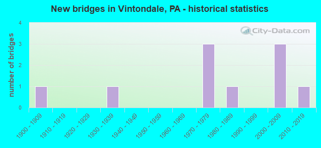
- New bridges - historical statistics
- 11900-1909
- 11930-1939
- 31970-1979
- 11980-1989
- 32000-2009
- 12010-2019

- Reconstructed bridges - Historical Statistics
- 11980-1989
- 01990-1999
- 02000-2009
- 12010-2019


- Bridge Condition - Deck
- 37.5%Very good
- 25.0%Good
- 12.5%Fair
- 25.0%Poor

- Bridge Condition - Superstructure
- 12.5%Excellent
- 25.0%Good
- 12.5%Satisfactory
- 37.5%Fair
- 12.5%Failed

- Bridge Condition - Substructure
- 25.0%Very good
- 12.5%Good
- 25.0%Satisfactory
- 12.5%Fair
- 12.5%Poor
- 12.5%Imminent failure

- Bridge Condition - Channel
- 28.6%Good
- 14.3%Satisfactory
- 42.9%Fair
- 14.3%Critical
Find on map >> Show street view
Structure Number: 8672, Location: VINTONDALE BORO. (Lat: 40.481011, Lng: -78.917692), Route carried "on" structure: State highway , Year Built: 1987, Status: Open, Structure Length: 3.90m (12.80ft), Average Daily Traffic: 429 (year 2022), Truck Traffic: 9%, Average Future Daily Traffic: 659 (year 2032), Design Load: HS 25 or greater, Features Intersected: S.BR.BLACKLICK CREEK, Facility Carried by Structure: SR 3045
Minimum Vertical Clearance: 30+ m (98+ ft), Kilometerpoint: 5.264, Lanes on structure: 2, Owner: State Highway Agency, Approaching Roadway Width: 8.5m (27.9ft), Material/Design: Prestressed concrete, Design/Construction: Box Beam or Girders - Multiple, Number Of Spans In Main Unit: 2, Length of Maximum Span: 19.2m (63.0ft), Curb or Sidewalk Widths: Left: 1.5m (4.9ft), Right: 0.2m (0.7ft), Curb-To-Curb Width: 8.5m (27.9ft), Out-to-Out Width: 10.9m (35.8ft)
Condition: Deck: Good, Superstructure: Good, Substructure: Good, Channel: Good, Inventory Rating: 59.0 metric tons, Method Used To Determine Inventory Rating: Load Factor (LF), Structural Evaluation: Better than present minimum criteria, Deck Geometry: Somewhat better than minimum adequacy, Waterway Adequacy: Superior to present desirable criteria, Approach Roadway Alignment: Equal to present desirable criteria, Length Of Structure Improvement: 4.70m (15.42ft), Designated Inspection Frequency: Every 48 months, Inspection Date: March 2019, Deck Structure Type: Concrete Cast-file-Place, Wearing Surface/Protective System: Wearing Surface: Epoxy Overlay, Deck Protection: Epoxy Coated Reinforcing
Find on map >> Show street view
Structure Number: 8736, Location: 2 MI.W.OF BELSANO (Lat: 40.515856, Lng: -78.903128), Route carried "on" structure: City street , Year Built: 1902, Year Reconstructed: 1988, Status: Closed, Structure Length: 2.74m (8.99ft), Average Daily Traffic: 200 (year 2021), Truck Traffic: 1%, Average Future Daily Traffic: 250 (year 2041), Design Load: H 10, Features Intersected: NORTH BR.BLACKLICK CREEK, Facility Carried by Structure: T-459, Red Mill Rd
Minimum Vertical Clearance: 4.98m (16.34ft), Kilometerpoint: 0.000, Lanes on structure: 1, Owner: County Highway Agency, Approaching Roadway Width: 4.3m (14.1ft), Material/Design: Steel, Design/Construction: Truss - Thru, Number Of Spans In Main Unit: 1, Length of Maximum Span: 26.8m (87.9ft), Curb-To-Curb Width: 4.1m (13.5ft), Out-to-Out Width: 4.4m (14.4ft)
Condition: Deck: Good, Superstructure: Failed, Substructure: Imminent failure, Channel: Critical, Operating Rating: 0.9 metric tons, Method Used To Determine Operating Rating: Load Factor (LF), Waterway Adequacy: Better than present minimum criteria, Approach Roadway Alignment: Meets minimum limits, Bridge Posting: Required (Relationship of Operating Rating to Maximum Legal Load: > 39.9% below), Length Of Structure Improvement: 3.40m (11.15ft), Designated Inspection Frequency: Every 24 months, Critical Feature Inspection Frequency: Every 24 months, Other Special Inspection Frequency: Every 6 months, Inspection Date: April 2021, Critical Feature Inspection Date: October 2021, Other Special Inspection Date: October 2021, Bridge Improvement Cost: $85,000, Roadway Improvement Cost: $264,000, Total Project Cost: $1,151,000, Deck Structure Type: Open Grating
Find on map >> Show street view
Structure Number: 8737, Location: 1 MI.NW.OF BELSANO (Lat: 40.528733, Lng: -78.887750), Route carried "on" structure: City street , Year Built: 1978, Year Reconstructed: 2019, Status: Open, Structure Length: 1.86m (6.10ft), Average Daily Traffic: 56 (year 2020), Average Future Daily Traffic: 77 (year 2040), Design Load: HS 20, Features Intersected: ELK CREEK, Facility Carried by Structure: T476,VIC MILLER RD
Minimum Vertical Clearance: 30+ m (98+ ft), Kilometerpoint: 0.000, Lanes on structure: 2, Owner: Town or Township Highway Agency, Approaching Roadway Width: 6.1m (20.0ft), Skew: 4 degrees, Material/Design: Prestressed concrete, Design/Construction: Box Beam or Girders - Multiple, Number Of Spans In Main Unit: 1, Length of Maximum Span: 18.0m (59.1ft), Curb-To-Curb Width: 7.6m (24.9ft), Out-to-Out Width: 8.0m (26.2ft)
Condition: Deck: Very good, Superstructure: Satisfactory, Substructure: Satisfactory, Channel: Good, Operating Rating: 74.4 metric tons, Method Used To Determine Operating Rating: Load Factor (LF), Inventory Rating: 31.8 metric tons, Method Used To Determine Inventory Rating: Load Factor (LF), Structural Evaluation: Equal to present minimum criteria, Deck Geometry: Equal to present minimum criteria, Waterway Adequacy: Equal to present desirable criteria, Approach Roadway Alignment: Equal to present desirable criteria, Length Of Structure Improvement: 2.50m (8.20ft), Designated Inspection Frequency: Every 24 months, Inspection Date: January 2020, Wearing Surface/Protective System: Wearing Surface: Monolithic Concrete, Deck Protection: Epoxy Coated Reinforcing
Find on map >> Show street view
Structure Number: 1929, Location: CLARKE RUN (Lat: 40.467294, Lng: -78.974650), Route carried "on" structure: State highway , Year Built: 1933, Status: Open, Structure Length: 0.85m (2.79ft), Average Daily Traffic: 142 (year 2020), Truck Traffic: 1%, Average Future Daily Traffic: 197 (year 2032), Design Load: H 20, Features Intersected: CLARKE RUN, Facility Carried by Structure: SR2012
Minimum Vertical Clearance: 30+ m (98+ ft), Kilometerpoint: 2.153, Lanes on structure: 2, Owner: State Highway Agency, Approaching Roadway Width: 4.9m (16.1ft), Material/Design: Concrete, Design/Construction: Tee Beam, Number Of Spans In Main Unit: 1, Length of Maximum Span: 7.9m (25.9ft), Curb or Sidewalk Widths: Left: 0.2m (0.7ft), Right: 0.2m (0.7ft), Curb-To-Curb Width: 6.9m (22.6ft), Out-to-Out Width: 7.9m (25.9ft)
Condition: Deck: Fair, Superstructure: Fair, Substructure: Fair, Channel: Fair, Operating Rating: 55.3 metric tons, Method Used To Determine Operating Rating: Load Factor (LF), Inventory Rating: 33.6 metric tons, Method Used To Determine Inventory Rating: Load Factor (LF), Structural Evaluation: Somewhat better than minimum adequacy, Deck Geometry: Meets minimum limits, Waterway Adequacy: Equal to present minimum criteria, Approach Roadway Alignment: Equal to present desirable criteria, Length Of Structure Improvement: 1.40m (4.59ft), Designated Inspection Frequency: Every 24 months, Inspection Date: October 2020, Deck Structure Type: Concrete Cast-file-Place, Wearing Surface/Protective System: Wearing Surface: Bituminous
Find on map >> Show street view
Structure Number: 19291, Location: PLEASANT VALLEY (Lat: 40.458669, Lng: -78.962828), Route carried "on" structure: State highway , Year Built: 1977, Status: Open, Structure Length: 3.14m (10.30ft), Average Daily Traffic: 142 (year 2020), Truck Traffic: 1%, Average Future Daily Traffic: 197 (year 2032), Design Load: HS 20, Features Intersected: BLACKLICK CREEK, Facility Carried by Structure: SR2012
Minimum Vertical Clearance: 30+ m (98+ ft), Kilometerpoint: 3.095, Lanes on structure: 1, Owner: State Highway Agency, Approaching Roadway Width: 5.5m (18.0ft), Material/Design: Steel continuous, Design/Construction: Stringer/Multi-beam, Number Of Spans In Main Unit: 2, Length of Maximum Span: 15.2m (49.9ft), Curb or Sidewalk Widths: Left: 0.2m (0.7ft), Right: 0.2m (0.7ft), Curb-To-Curb Width: 4.3m (14.1ft), Out-to-Out Width: 5.0m (16.4ft)
Condition: Deck: Poor, Superstructure: Fair, Substructure: Poor, Channel: Fair, Inventory Rating: 68.9 metric tons, Method Used To Determine Inventory Rating: Load Factor (LF), Structural Evaluation: Meets minimum limits, Deck Geometry: High priority of replacement, Waterway Adequacy: Equal to present desirable criteria, Approach Roadway Alignment: Somewhat better than minimum adequacy, Length Of Structure Improvement: 3.90m (12.80ft), Designated Inspection Frequency: Every 24 months, Other Special Inspection Frequency: Every 12 months, Inspection Date: September 2020, Other Special Inspection Date: September 2021, Bridge Improvement Cost: $7,000, Roadway Improvement Cost: $41,000, Total Project Cost: $99,000, Deck Structure Type: Open Grating
Find on map >> Show street view
Structure Number: 19307, Location: WEST OF VINTONDALE (Lat: 40.484253, Lng: -78.923086), Route carried "on" structure: State highway , Year Built: 1971, Status: Open, Structure Length: 2.74m (8.99ft), Average Daily Traffic: 423 (year 2022), Truck Traffic: 9%, Average Future Daily Traffic: 667 (year 2032), Design Load: HS 20, Features Intersected: N BR OF BLACKLICK CR, Facility Carried by Structure: SR2026
Minimum Vertical Clearance: 30+ m (98+ ft), Kilometerpoint: 0.000, Lanes on structure: 2, Owner: State Highway Agency, Approaching Roadway Width: 7.6m (24.9ft), Skew: 1 degrees, Material/Design: Prestressed concrete, Design/Construction: Box Beam or Girders - Multiple, Number Of Spans In Main Unit: 1, Length of Maximum Span: 26.8m (87.9ft), Curb or Sidewalk Widths: Left: 0.2m (0.7ft), Right: 0.2m (0.7ft), Curb-To-Curb Width: 13.4m (44.0ft), Out-to-Out Width: 14.6m (47.9ft)
Condition: Deck: Poor, Superstructure: Fair, Substructure: Satisfactory, Channel: Fair, Operating Rating: 86.2 metric tons, Method Used To Determine Operating Rating: Load Factor (LF), Inventory Rating: 11.8 metric tons, Method Used To Determine Inventory Rating: Load Factor (LF), Structural Evaluation: Meets minimum limits, Deck Geometry: Superior to present desirable criteria, Waterway Adequacy: Equal to present desirable criteria, Approach Roadway Alignment: Equal to present desirable criteria, Length Of Structure Improvement: 3.50m (11.48ft), Designated Inspection Frequency: Every 24 months, Inspection Date: May 2020, Bridge Improvement Cost: $12,000, Roadway Improvement Cost: $55,000, Total Project Cost: $156,000, Deck Structure Type: Concrete Cast-file-Place, Wearing Surface/Protective System: Wearing Surface: Monolithic Concrete
Find on map >> Show street view
Structure Number: 43267, Location: SR 3041 OVER US 22 (Lat: 40.434194, Lng: -78.911861), Route carried "on" structure: State highway , Year Built: 2006, Status: Open, Structure Length: 7.13m (23.39ft), Average Daily Traffic: 800 (year 2022), Truck Traffic: 4%, Average Future Daily Traffic: 1,150 (year 2032), Design Load: HL 93, Features Intersected: US 22, Facility Carried by Structure: SR 3041
Minimum Vertical Clearance: 30+ m (98+ ft), Kilometerpoint: 8.637, Lanes on structure: 2, Lanes under structure: 5, Owner: State Highway Agency, Approaching Roadway Width: 11.9m (39.0ft), Material/Design: Prestressed concrete, Design/Construction: Stringer/Multi-beam, Number Of Spans In Main Unit: 2, Length of Maximum Span: 34.4m (112.9ft), Curb or Sidewalk Widths: Left: 0.2m (0.7ft), Right: 0.2m (0.7ft), Curb-To-Curb Width: 12.0m (39.4ft), Out-to-Out Width: 12.9m (42.3ft)
Condition: Deck: Very good, Superstructure: Good, Substructure: Very good, Operating Rating: 71.7 metric tons, Method Used To Determine Operating Rating: Load Factor (LF), Inventory Rating: 38.1 metric tons, Method Used To Determine Inventory Rating: Load Factor (LF), Structural Evaluation: Better than present minimum criteria, Deck Geometry: Better than present minimum criteria, Underclear: Better than present minimum criteria, Approach Roadway Alignment: Equal to present desirable criteria, Designated Inspection Frequency: Every 48 months, Inspection Date: April 2019, Deck Structure Type: Concrete Cast-file-Place, Wearing Surface/Protective System: Wearing Surface: Monolithic Concrete, Deck Protection: Epoxy Coated Reinforcing
Find on map >> Show street view
Structure Number: 53412, Location: 2.4 Mi N SR 22 Inter. (Lat: 40.470733, Lng: -78.950203), Route carried "on" structure: State highway , Year Built: 2016, Status: Open, Structure Length: 8.50m (27.89ft), Average Daily Traffic: 134 (year 2022), Truck Traffic: 8%, Average Future Daily Traffic: 189 (year 2032), Design Load: HL 93, Features Intersected: BLACKLICK CREEK, Facility Carried by Structure: SR 2013
Minimum Vertical Clearance: 30+ m (98+ ft), Kilometerpoint: 10.881, Lanes on structure: 2, Owner: State Highway Agency, Approaching Roadway Width: 6.7m (22.0ft), Skew: 2 degrees, Material/Design: Steel continuous, Design/Construction: Stringer/Multi-beam, Number Of Spans In Main Unit: 3, Length of Maximum Span: 31.1m (102.0ft), Curb or Sidewalk Widths: Left: 0.2m (0.7ft), Right: 0.2m (0.7ft), Curb-To-Curb Width: 8.5m (27.9ft), Out-to-Out Width: 9.6m (31.5ft)
Condition: Deck: Very good, Superstructure: Excellent, Substructure: Very good, Channel: Satisfactory, Operating Rating: 48.3 metric tons, Method Used To Determine Operating Rating: Assigned ratings based on Load and Resistance Factor Design (LRFD) reported by rating factor (RF) using HL93 loadings, Inventory Rating: 37.3 metric tons, Method Used To Determine Inventory Rating: Assigned ratings based on Load and Resistance Factor Design (LRFD) reported by rating factor (RF) using HL93 loadings, Structural Evaluation: Equal to present desirable criteria, Deck Geometry: Equal to present minimum criteria, Waterway Adequacy: Better than present minimum criteria, Approach Roadway Alignment: Better than present minimum criteria, Designated Inspection Frequency: Every 48 months, Inspection Date: May 2020, Deck Structure Type: Concrete Cast-file-Place, Wearing Surface/Protective System: Wearing Surface: Monolithic Concrete, Deck Protection: Epoxy Coated Reinforcing
Find on map >> Show street view
Structure Number: 43267, Location: SR 3041 OVER US 22 (Lat: 40.434194, Lng: -78.911861), Route carried "under" structure: US 22, Year Built: 2006, Structure Length: 0. m, Average Daily Traffic: 5,528 (year 2020), Truck Traffic: 24%, Features Intersected: US 22, Facility Carried by Structure: SR 3041
Minimum Vertical Clearance: 5.59m (18.34ft), Kilometerpoint: 2.795, Lanes on structure: 2, Lanes under structure: 2, Material/Design: Prestressed concrete, Design/Construction: Stringer/Multi-beam, Length of Maximum Span: 34.4m (112.9ft)
Find on map >> Show street view
Structure Number: 43267, Location: SR 3041 OVER US 22 (Lat: 40.434194, Lng: -78.911861), Route carried "under" structure: US 22, Year Built: 2006, Structure Length: 0. m, Average Daily Traffic: 5,756 (year 2022), Truck Traffic: 21%, Features Intersected: US 22, Facility Carried by Structure: SR 3041
Minimum Vertical Clearance: 6.04m (19.82ft), Kilometerpoint: 2.821, Lanes on structure: 2, Lanes under structure: 3, Material/Design: Prestressed concrete, Design/Construction: Stringer/Multi-beam, Length of Maximum Span: 34.4m (112.9ft)