Bridge Statistics for Vienna, Wisconsin (WI)
Condition, Traffic, Stress, Structural Evaluation, Project Costs
- National Bridge Inventory (NBI) Statistics
- 13Number of bridges
- 108ft / 33.4mTotal length
- 264,910Total average daily traffic
- 17,975Total average daily truck traffic
- National Bridge Inventory (NBI) Registered Bridges for Vienna
- No street view available for this location
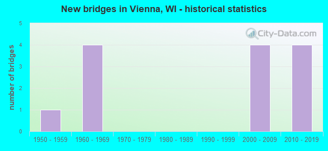
- New bridges - historical statistics
- 11950-1959
- 41960-1969
- 42000-2009
- 42010-2019

- Reconstructed bridges - Historical Statistics
- 21970-1979
- 01980-1989
- 01990-1999
- 12000-2009


- Bridge Condition - Deck
- 50.0%Good
- 16.7%Satisfactory
- 33.3%Fair

- Bridge Condition - Superstructure
- 33.3%Very good
- 16.7%Good
- 16.7%Satisfactory
- 33.3%Fair

- Bridge Condition - Substructure
- 33.3%Very good
- 16.7%Good
- 50.0%Satisfactory

- Bridge Condition - Channel
- 66.7%Very good
- 33.3%Good
Find on map >> Show street view
Structure Number: B13008, Location: 3.4M S JCT CTH V (S) (Lat: 43.234300, Lng: -89.153683), Route carried "on" structure: US 151, Year Built: 1959, Year Reconstructed: 2009, Status: Open, Structure Length: 1.36m (4.46ft), Average Daily Traffic: 11,540 (year 2019), Truck Traffic: 8%, Average Future Daily Traffic: 30,100 (year 2040), Design Load: HL 93, Features Intersected: MAUNESHA RIVER
Minimum Vertical Clearance: 30+ m (98+ ft), Kilometerpoint: 0.000, Lanes on structure: 2, Base Highway Network: Yes, Owner: State Highway Agency, Approaching Roadway Width: 12.2m (40.0ft), Skew: 3 degrees, Material/Design: Concrete, Design/Construction: Slab, Number Of Spans In Main Unit: 1, Length of Maximum Span: 13.6m (44.6ft), Curb-To-Curb Width: 13.4m (44.0ft), Out-to-Out Width: 14.3m (46.9ft)
Condition: Deck: Good, Superstructure: Good, Substructure: Satisfactory, Channel: Very good, Operating Rating: 44.1 metric tons, Method Used To Determine Operating Rating: Load and Resistance Factor Rating (LRFR) rating reported by rating factor(RF) method using HL-93 loadings, Inventory Rating: 34.0 metric tons, Method Used To Determine Inventory Rating: Load and Resistance Factor Rating (LRFR) rating reported by rating factor(RF) method using HL-93 loadings, Structural Evaluation: Equal to present minimum criteria, Deck Geometry: Superior to present desirable criteria, Waterway Adequacy: Equal to present desirable criteria, Approach Roadway Alignment: Equal to present desirable criteria, Designated Inspection Frequency: Every 24 months, Inspection Date: March 2021, Deck Structure Type: Concrete Cast-file-Place, Wearing Surface/Protective System: Wearing Surface: Monolithic Concrete, Deck Protection: Epoxy Coated Reinforcing
Find on map >> Show street view
Structure Number: B130087, Location: 1.9M S JCT CTH V (Lat: 43.221436, Lng: -89.363886), Route carried "on" structure: Interstate 90, Year Built: 1960, Year Reconstructed: 1984, Status: Open, Structure Length: 3.36m (11.02ft), Average Daily Traffic: 27,800 (year 2019), Truck Traffic: 16%, Average Future Daily Traffic: 51,527 (year 2039), Design Load: H 20, Features Intersected: LRD CUBA VALLEY RD
Minimum Vertical Clearance: 30+ m (98+ ft), Kilometerpoint: 0.000, Lanes on structure: 3, Lanes under structure: 2, Base Highway Network: Yes, Owner: State Highway Agency, Approaching Roadway Width: 18.9m (62.0ft), Skew: 1 degrees, Material/Design: Concrete continuous, Design/Construction: Slab, Number Of Spans In Main Unit: 3, Length of Maximum Span: 13.1m (43.0ft), Curb-To-Curb Width: 17.1m (56.1ft), Out-to-Out Width: 17.8m (58.4ft)
Condition: Deck: Fair, Superstructure: Fair, Substructure: Satisfactory, Operating Rating: 55.5 metric tons, Method Used To Determine Operating Rating: Load Factor (LF), Inventory Rating: 21.1 metric tons, Method Used To Determine Inventory Rating: Load Factor (LF), Structural Evaluation: Somewhat better than minimum adequacy, Deck Geometry: Equal to present minimum criteria, Underclear: Meets minimum limits, Approach Roadway Alignment: Equal to present desirable criteria, Designated Inspection Frequency: Every 24 months, Inspection Date: June 2020, Deck Structure Type: Concrete Cast-file-Place, Wearing Surface/Protective System: Wearing Surface: Low Slump Concrete
Find on map >> Show street view
Structure Number: B130088, Location: 2.4M W JCT STH 19 TO E (Lat: 43.221147, Lng: -89.363258), Route carried "on" structure: Interstate 90, Year Built: 1960, Year Reconstructed: 1984, Status: Open, Structure Length: 3.31m (10.86ft), Average Daily Traffic: 28,500 (year 2019), Truck Traffic: 16%, Average Future Daily Traffic: 51,527 (year 2039), Design Load: HS 20, Features Intersected: LRD CUBA VALLEY RD
Minimum Vertical Clearance: 30+ m (98+ ft), Kilometerpoint: 0.000, Lanes on structure: 3, Lanes under structure: 2, Base Highway Network: Yes, Owner: State Highway Agency, Approaching Roadway Width: 18.9m (62.0ft), Skew: 1 degrees, Material/Design: Concrete continuous, Design/Construction: Slab, Number Of Spans In Main Unit: 3, Length of Maximum Span: 13.1m (43.0ft), Curb-To-Curb Width: 17.1m (56.1ft), Out-to-Out Width: 17.8m (58.4ft)
Condition: Deck: Fair, Superstructure: Fair, Substructure: Satisfactory, Operating Rating: 55.5 metric tons, Method Used To Determine Operating Rating: Load Factor (LF), Inventory Rating: 21.1 metric tons, Method Used To Determine Inventory Rating: Load Factor (LF), Structural Evaluation: Somewhat better than minimum adequacy, Deck Geometry: Equal to present minimum criteria, Underclear: Somewhat better than minimum adequacy, Approach Roadway Alignment: Equal to present desirable criteria, Designated Inspection Frequency: Every 24 months, Inspection Date: June 2020, Deck Structure Type: Concrete Cast-file-Place, Wearing Surface/Protective System: Wearing Surface: Low Slump Concrete
Find on map >> Show street view
Structure Number: B130511, Location: CITY OF MADISON (Lat: 43.121000, Lng: -89.302772), Route carried "on" structure: City street , Year Built: 2000, Status: Open, Structure Length: 0.68m (2.23ft), Average Daily Traffic: 12,941 (year 2019), Truck Traffic: 8%, Average Future Daily Traffic: 14,235 (year 2039), Design Load: HS 20, Features Intersected: E BR STARKWEATHER CREEK, Facility Carried by Structure: LRD LIEN ROAD
Minimum Vertical Clearance: 30+ m (98+ ft), Kilometerpoint: 0.000, Lanes on structure: 4, Owner: City or Municipal Highway Agency, Approaching Roadway Width: 16.8m (55.1ft), Skew: 3 degrees, Material/Design: Concrete, Design/Construction: Culvert, Number Of Spans In Main Unit: 2, Length of Maximum Span: 2.4m (7.9ft), Curb-To-Curb Width: 16.8m (55.1ft), Out-to-Out Width: 37.3m (122.4ft)
Condition: Channel: Good, Culverts: Good, Operating Rating: 53.9 metric tons, Method Used To Determine Operating Rating: Field evaluation and documented engineering judgment, Inventory Rating: 32.4 metric tons, Method Used To Determine Inventory Rating: Field evaluation and documented engineering judgment, Structural Evaluation: Better than present minimum criteria, Deck Geometry: Somewhat better than minimum adequacy, Waterway Adequacy: Better than present minimum criteria, Approach Roadway Alignment: Equal to present desirable criteria, Designated Inspection Frequency: Every 48 months, Inspection Date: October 2020, Deck Structure Type: Concrete Cast-file-Place, Wearing Surface/Protective System: Wearing Surface: Bituminous
Find on map >> Show street view
Structure Number: B130517, Location: TOWN OF VIENNA (Lat: 43.250333, Lng: -89.378161), Route carried "on" structure: County highway , Year Built: 2002, Status: Open, Structure Length: 7.08m (23.23ft), Average Daily Traffic: 7,200 (year 2019), Truck Traffic: 4%, Average Future Daily Traffic: 14,000 (year 2040), Design Load: HS 20, Features Intersected: IH 90/94, Facility Carried by Structure: CTH V
Minimum Vertical Clearance: 30+ m (98+ ft), Kilometerpoint: 0.000, Lanes on structure: 6, Lanes under structure: 6, Owner: State Highway Agency, Approaching Roadway Width: 26.5m (86.9ft), Skew: 32 degrees, Material/Design: Prestressed concrete continuous, Design/Construction: Stringer/Multi-beam, Number Of Spans In Main Unit: 2, Length of Maximum Span: 34.8m (114.2ft), Curb or Sidewalk Widths: Left: 1.5m (4.9ft), Right: 1.0m (3.3ft), Curb-To-Curb Width: 26.6m (87.3ft), Out-to-Out Width: 30.2m (99.1ft)
Condition: Deck: Satisfactory, Superstructure: Satisfactory, Substructure: Good, Inventory Rating: 35.6 metric tons, Method Used To Determine Inventory Rating: Load Factor (LF), Structural Evaluation: Equal to present minimum criteria, Deck Geometry: Equal to present minimum criteria, Underclear: Better than present minimum criteria, Approach Roadway Alignment: Equal to present desirable criteria, Designated Inspection Frequency: Every 24 months, Inspection Date: July 2021, Deck Structure Type: Concrete Cast-file-Place, Wearing Surface/Protective System: Wearing Surface: Monolithic Concrete, Deck Protection: Epoxy Coated Reinforcing
Find on map >> Show street view
Structure Number: B130631, Location: 0.1 MI. WEST OF DEMING WA (Lat: 43.101667, Lng: -89.521389), Route carried "on" structure: City street , Year Built: 2007, Status: Open, Structure Length: 1.12m (3.67ft), Average Daily Traffic: 257 (year 2019), Average Future Daily Traffic: 282 (year 2039), Design Load: HS 20, Features Intersected: PHEASANT BRANCH CREEK, Facility Carried by Structure: LRD U.W. HEALTH CT
Minimum Vertical Clearance: 30+ m (98+ ft), Kilometerpoint: 0.000, Lanes on structure: 2, Owner: City or Municipal Highway Agency, Approaching Roadway Width: 7.3m (24.0ft), Material/Design: Concrete continuous, Design/Construction: Culvert, Number Of Spans In Main Unit: 4, Length of Maximum Span: 1.2m (3.9ft)
Condition: Channel: Very good, Culverts: Good, Operating Rating: 53.9 metric tons, Method Used To Determine Operating Rating: Field evaluation and documented engineering judgment, Inventory Rating: 32.4 metric tons, Method Used To Determine Inventory Rating: Field evaluation and documented engineering judgment, Structural Evaluation: Better than present minimum criteria, Waterway Adequacy: Equal to present desirable criteria, Approach Roadway Alignment: Equal to present desirable criteria, Designated Inspection Frequency: Every 48 months, Inspection Date: September 2020, Deck Structure Type: Concrete Cast-file-Place, Wearing Surface/Protective System: Wearing Surface: Bituminous
Find on map >> Show street view
Structure Number: B130639, Location: 0.5M N JCT CTH V (Lat: 43.257600, Lng: -89.383022), Route carried "on" structure: County highway , Year Built: 2013, Status: Open, Structure Length: 8.38m (27.49ft), Average Daily Traffic: 2,200 (year 2019), Truck Traffic: 5%, Average Future Daily Traffic: 2,900 (year 2040), Design Load: HL 93, Features Intersected: IH 39 NB, Facility Carried by Structure: CTH I
Minimum Vertical Clearance: 30+ m (98+ ft), Kilometerpoint: 0.000, Lanes on structure: 2, Lanes under structure: 6, Owner: State Highway Agency, Approaching Roadway Width: 12.2m (40.0ft), Skew: 4 degrees, Material/Design: Prestressed concrete continuous, Design/Construction: Stringer/Multi-beam, Number Of Spans In Main Unit: 2, Length of Maximum Span: 41.1m (134.8ft), Curb-To-Curb Width: 12.2m (40.0ft), Out-to-Out Width: 13.0m (42.7ft)
Condition: Deck: Good, Superstructure: Very good, Substructure: Very good, Operating Rating: 47.6 metric tons, Method Used To Determine Operating Rating: Load and Resistance Factor Rating (LRFR) rating reported by rating factor(RF) method using HL-93 loadings, Inventory Rating: 36.6 metric tons, Method Used To Determine Inventory Rating: Load and Resistance Factor Rating (LRFR) rating reported by rating factor(RF) method using HL-93 loadings, Structural Evaluation: Equal to present desirable criteria, Deck Geometry: Equal to present minimum criteria, Underclear: Equal to present minimum criteria, Approach Roadway Alignment: Equal to present minimum criteria, Designated Inspection Frequency: Every 48 months, Inspection Date: September 2021, Deck Structure Type: Concrete Cast-file-Place, Wearing Surface/Protective System: Wearing Surface: Monolithic Concrete, Deck Protection: Epoxy Coated Reinforcing
Find on map >> Show street view
Structure Number: B130648, Location: 0.8 MI W OF JCT WITH CTH (Lat: 43.275703, Lng: -89.399203), Route carried "on" structure: County highway , Year Built: 2017, Status: Open, Structure Length: 8.08m (26.51ft), Average Daily Traffic: 940 (year 2019), Average Future Daily Traffic: 1,100 (year 2040), Design Load: HL 93, Features Intersected: IH 39/90/94, Facility Carried by Structure: CTH DM
Minimum Vertical Clearance: 30+ m (98+ ft), Kilometerpoint: 0.000, Lanes on structure: 2, Lanes under structure: 6, Owner: State Highway Agency, Approaching Roadway Width: 10.4m (34.1ft), Skew: 5 degrees, Material/Design: Prestressed concrete continuous, Design/Construction: Stringer/Multi-beam, Number Of Spans In Main Unit: 2, Length of Maximum Span: 39.9m (130.9ft), Curb-To-Curb Width: 9.8m (32.2ft), Out-to-Out Width: 10.5m (34.4ft)
Condition: Deck: Good, Superstructure: Very good, Substructure: Very good, Operating Rating: 50.5 metric tons, Method Used To Determine Operating Rating: Load and Resistance Factor Rating (LRFR) rating reported by rating factor(RF) method using HL-93 loadings, Inventory Rating: 38.9 metric tons, Method Used To Determine Inventory Rating: Load and Resistance Factor Rating (LRFR) rating reported by rating factor(RF) method using HL-93 loadings, Structural Evaluation: Equal to present desirable criteria, Deck Geometry: Equal to present minimum criteria, Underclear: Equal to present minimum criteria, Approach Roadway Alignment: Equal to present desirable criteria, Designated Inspection Frequency: Every 24 months, Inspection Date: November 2021, Deck Structure Type: Concrete Cast-file-Place, Wearing Surface/Protective System: Wearing Surface: Epoxy Overlay, Deck Protection: Epoxy Coated Reinforcing
Find on map >> Show street view
Structure Number: B130087, Location: 1.9M E JCT CTH I (Lat: 43.221436, Lng: -89.363886), Route carried "under" structure: City street , Year Built: 1960, Structure Length: 0. m, Average Daily Traffic: 566 (year 2019), Features Intersected: LRD CUBA VALLEY RD, Facility Carried by Structure: IH 39 SB/90 EB/94
Minimum Vertical Clearance: 4.42m (14.50ft), Kilometerpoint: 0.000, Lanes on structure: 3, Lanes under structure: 2, Material/Design: Concrete continuous, Design/Construction: Slab, Length of Maximum Span: 13.1m (43.0ft)
Find on map >> Show street view
Structure Number: B130088, Location: 1.9M E JCT CTH I (Lat: 43.221147, Lng: -89.363258), Route carried "under" structure: City street , Year Built: 1960, Structure Length: 0. m, Average Daily Traffic: 566 (year 2019), Features Intersected: LRD CUBA VALLEY RD, Facility Carried by Structure: IH 39 NB IH 90 & 9
Minimum Vertical Clearance: 4.42m (14.50ft), Kilometerpoint: 0.000, Lanes on structure: 3, Lanes under structure: 2, Material/Design: Concrete continuous, Design/Construction: Slab, Length of Maximum Span: 13.1m (43.0ft)
Find on map >> Show street view
Structure Number: B130517, Location: TOWN OF VIENNA (Lat: 43.250333, Lng: -89.378161), Route carried "under" structure: Interstate 90, Year Built: 2002, Structure Length: 0. m, Average Daily Traffic: 48,300 (year 2019), Features Intersected: IH 90/94, Facility Carried by Structure: CTH V
Minimum Vertical Clearance: 5.24m (17.19ft), Kilometerpoint: 0.000, Lanes on structure: 6, Lanes under structure: 6, Material/Design: Prestressed concrete continuous, Design/Construction: Stringer/Multi-beam, Length of Maximum Span: 34.8m (114.2ft)
Find on map >> Show street view
Structure Number: B130639, Location: AT CTH I (Lat: 43.257600, Lng: -89.383022), Route carried "under" structure: Interstate 39, Year Built: 2013, Structure Length: 0. m, Average Daily Traffic: 60,100 (year 2019), Truck Traffic: 11%, Features Intersected: IH 39 NB, Facility Carried by Structure: CTH I
Minimum Vertical Clearance: 5.26m (17.26ft), Kilometerpoint: 0.000, Lanes on structure: 2, Lanes under structure: 6, Material/Design: Prestressed concrete continuous, Design/Construction: Stringer/Multi-beam, Length of Maximum Span: 41.1m (134.8ft)
Find on map >> Show street view
Structure Number: B130648, Location: 2 MI N OF JCT WITH CTH V (Lat: 43.275703, Lng: -89.399203), Route carried "under" structure: Interstate 39, Year Built: 2017, Structure Length: 0. m, Average Daily Traffic: 64,000 (year 2019), Features Intersected: IH 39/90/94, Facility Carried by Structure: CTH DM
Minimum Vertical Clearance: 5.38m (17.65ft), Kilometerpoint: 0.000, Lanes on structure: 2, Lanes under structure: 6, Material/Design: Prestressed concrete continuous, Design/Construction: Stringer/Multi-beam, Length of Maximum Span: 39.9m (130.9ft)