Bridge Statistics for Victorville, California (CA)
Condition, Traffic, Stress, Structural Evaluation, Project Costs
- National Bridge Inventory (NBI) Statistics
- 38Number of bridges
- 725ft / 221mTotal length
- $7,385,000Total costs
- 1,391,209Total average daily traffic
- 229,498Total average daily truck traffic
- National Bridge Inventory (NBI) Registered Bridges for Victorville
- No street view available for this location
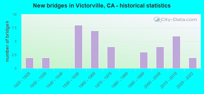
- New bridges - historical statistics
- 21920-1929
- 21930-1939
- 81950-1959
- 71960-1969
- 41970-1979
- 31990-1999
- 42000-2009
- 62010-2019
- 22020-2022
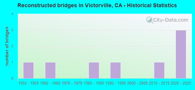
- Reconstructed bridges - Historical Statistics
- 11950-1959
- 11960-1969
- 01970-1979
- 11980-1989
- 11990-1999
- 02000-2009
- 12010-2019
- 32020-2022
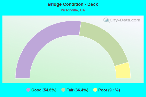
- Bridge Condition - Deck
- 54.5%Good
- 36.4%Fair
- 9.1%Poor
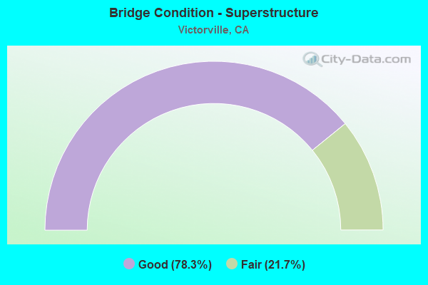
- Bridge Condition - Superstructure
- 78.3%Good
- 21.7%Fair
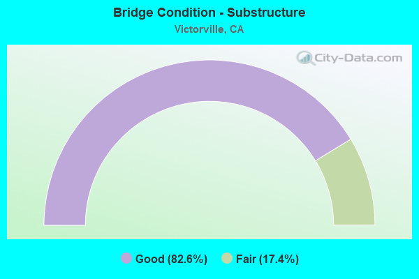
- Bridge Condition - Substructure
- 82.6%Good
- 17.4%Fair
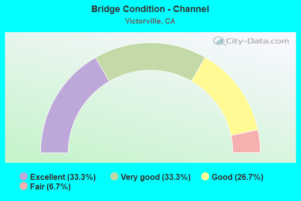
- Bridge Condition - Channel
- 33.3%Excellent
- 33.3%Very good
- 26.7%Good
- 6.7%Fair
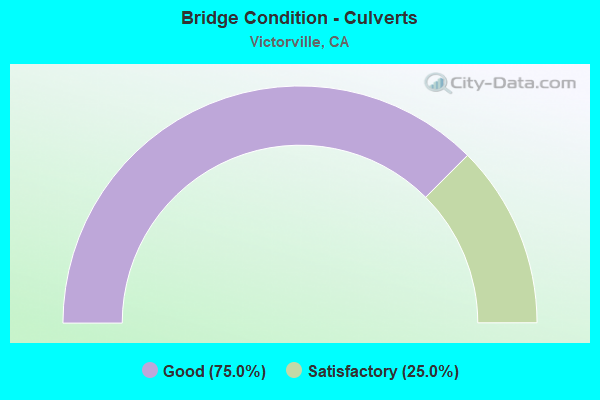
- Bridge Condition - Culverts
- 75.0%Good
- 25.0%Satisfactory
Find on map >> Show street view
Structure Number: 54 0307, Location: 08-SBD-018-95.35 (Lat: 34.533892, Lng: -117.286786), Route carried "on" structure: State highway 18, Year Built: 1962, Status: Open, Structure Length: 13.62m (44.69ft), Average Daily Traffic: 42,000 (year 2017), Truck Traffic: 12%, Average Future Daily Traffic: 55,000 (year 2040), Design Load: HS 20, Features Intersected: BNSF RY,UP,AMTRAK,MOJAVE
Minimum Vertical Clearance: 30+ m (98+ ft), Kilometerpoint: 95.350, Lanes on structure: 4, Base Highway Network: Yes (, Subroute: 1), Owner: State Highway Agency, Approaching Roadway Width: 17.6m (57.7ft), Skew: 39 degrees, Material/Design: Steel, Design/Construction: Stringer/Multi-beam, Number Of Spans In Main Unit: 5, Length of Maximum Span: 30.5m (100.1ft), Curb or Sidewalk Widths: Left: 0.0m, Right: 1.5m (4.9ft), Curb-To-Curb Width: 17.6m (57.7ft), Out-to-Out Width: 22.5m (73.8ft)
Condition: Deck: Fair, Superstructure: Good, Substructure: Good, Channel: Very good, Operating Rating: 78.7 metric tons, Method Used To Determine Operating Rating: Load Factor (LF), Inventory Rating: 47.0 metric tons, Method Used To Determine Inventory Rating: Load Factor (LF), Structural Evaluation: Better than present minimum criteria, Deck Geometry: Somewhat better than minimum adequacy, Underclear: Somewhat better than minimum adequacy, Waterway Adequacy: Superior to present desirable criteria, Approach Roadway Alignment: High priority of corrective action, Designated Inspection Frequency: Every 24 months, Other Special Inspection Frequency: Every 48 months, Inspection Date: November 2020, Other Special Inspection Date: March 2020, Deck Structure Type: Concrete Cast-file-Place
Find on map >> Show street view
Structure Number: 54 0483, Location: 08-SBD-015-43.86-VCTV (Lat: 34.548414, Lng: -117.295392), Route carried "on" structure: Interstate 15, Year Built: 1958, Year Reconstructed: 2020, Status: Open, Structure Length: 17.53m (57.51ft), Average Daily Traffic: 63,000 (year 2017), Truck Traffic: 24%, Average Future Daily Traffic: 80,000 (year 2040), Design Load: HS 20, Features Intersected: MOJAVE RIVER
Minimum Vertical Clearance: 30+ m (98+ ft), Kilometerpoint: 43.860, Lanes on structure: 8, Base Highway Network: Yes (, Subroute: 1), Owner: State Highway Agency, Approaching Roadway Width: 44.2m (145.0ft), Skew: 32 degrees, Material/Design: Concrete continuous, Design/Construction: Tee Beam, Number Of Spans In Main Unit: 8, Length of Maximum Span: 22.9m (75.1ft), Curb-To-Curb Width: 44.2m (145.0ft), Out-to-Out Width: 45.7m (149.9ft)
Condition: Deck: Good, Superstructure: Good, Substructure: Good, Channel: Very good, Operating Rating: 34.7 metric tons, Method Used To Determine Operating Rating: Load and Resistance Factor Rating (LRFR) rating reported by rating factor(RF) method using HL-93 loadings, Inventory Rating: 26.9 metric tons, Method Used To Determine Inventory Rating: Load and Resistance Factor Rating (LRFR) rating reported by rating factor(RF) method using HL-93 loadings, Structural Evaluation: Equal to present minimum criteria, Deck Geometry: Superior to present desirable criteria, Waterway Adequacy: Equal to present desirable criteria, Approach Roadway Alignment: Equal to present minimum criteria, Designated Inspection Frequency: Every 24 months, Inspection Date: April 2020, Deck Structure Type: Concrete Cast-file-Place, Wearing Surface/Protective System: Wearing Surface: Integral Concrete
Find on map >> Show street view
Structure Number: 54 0484, Location: 08-SBD-015-43.47-VCTV (Lat: 34.545047, Lng: -117.300908), Route carried "on" structure: Interstate 15, Year Built: 1958, Year Reconstructed: 2020, Status: Open, Structure Length: 11.64m (38.19ft), Average Daily Traffic: 69,000 (year 2017), Truck Traffic: 22%, Average Future Daily Traffic: 80,000 (year 2040), Design Load: HS 20, Features Intersected: BNSF RY,UP RR,AMTRAK,ETC
Minimum Vertical Clearance: 30+ m (98+ ft), Kilometerpoint: 43.470, Lanes on structure: 8, Lanes under structure: 8, Base Highway Network: Yes (, Subroute: 1), Owner: State Highway Agency, Approaching Roadway Width: 41.6m (136.5ft), Skew: 31 degrees, Material/Design: Steel, Design/Construction: Stringer/Multi-beam, Number Of Spans In Main Unit: 6, Length of Maximum Span: 32.6m (107.0ft), Curb-To-Curb Width: 41.6m (136.5ft), Out-to-Out Width: 43.1m (141.4ft)
Condition: Deck: Good, Superstructure: Good, Substructure: Good, Operating Rating: 79.7 metric tons, Method Used To Determine Operating Rating: Load Factor (LF), Inventory Rating: 47.6 metric tons, Method Used To Determine Inventory Rating: Load Factor (LF), Structural Evaluation: Better than present minimum criteria, Deck Geometry: Superior to present desirable criteria, Underclear: Meets minimum limits, Approach Roadway Alignment: Equal to present desirable criteria, Designated Inspection Frequency: Every 24 months, Inspection Date: April 2020, Deck Structure Type: Concrete Cast-file-Place, Wearing Surface/Protective System: Wearing Surface: Integral Concrete
Find on map >> Show street view
Structure Number: 54 0484G, Location: 08-SBD-015-43.48-VCTV (Lat: 34.545000, Lng: -117.300611), Route carried "on" structure: Ramp Interstate 15, Year Built: 2020, Status: Open, Structure Length: 11.58m (37.99ft), Average Daily Traffic: 1,000 (year 2020), Truck Traffic: 5%, Average Future Daily Traffic: 3,000 (year 2040), Design Load: Greater than HL93, Features Intersected: BNSF RY,UP RR,AMTRAK,ETC
Minimum Vertical Clearance: 99.90m (327.76ft), Kilometerpoint: 43.480, Lanes on structure: 2, Lanes under structure: 8, Base Highway Network: Yes (, Subroute: 1), Owner: State Highway Agency, Approaching Roadway Width: 11.9m (39.0ft), Skew: 1 degrees, Material/Design: Concrete continuous, Design/Construction: Stringer/Multi-beam, Number Of Spans In Main Unit: 6, Length of Maximum Span: 32.5m (106.6ft), Curb-To-Curb Width: 11.9m (39.0ft), Out-to-Out Width: 12.8m (42.0ft)
Condition: Deck: Good, Superstructure: Good, Substructure: Good, Operating Rating: 42.1 metric tons, Method Used To Determine Operating Rating: Assigned ratings based on Load and Resistance Factor Design (LRFD) reported by rating factor (RF) using HL93 loadings, Inventory Rating: 32.4 metric tons, Method Used To Determine Inventory Rating: Assigned ratings based on Load and Resistance Factor Design (LRFD) reported by rating factor (RF) using HL93 loadings, Structural Evaluation: Better than present minimum criteria, Deck Geometry: Superior to present desirable criteria, Underclear: Meets minimum limits, Approach Roadway Alignment: Equal to present desirable criteria, Designated Inspection Frequency: Every 24 months, Inspection Date: April 2020, Deck Structure Type: Concrete Cast-file-Place, Wearing Surface/Protective System: Deck Protection: Epoxy Coated Reinforcing
Find on map >> Show street view
Structure Number: 54 0517, Location: 08-SBD-015-46.40-VCTV (Lat: 34.578375, Lng: -117.270300), Route carried "on" structure: Interstate 15, Year Built: 1958, Year Reconstructed: 2004, Status: Open, Structure Length: 0.82m (2.69ft), Average Daily Traffic: 63,000 (year 2017), Truck Traffic: 24%, Average Future Daily Traffic: 80,000 (year 2040), Design Load: HS 20, Features Intersected: CEMENT COMPANY ROAD
Minimum Vertical Clearance: 30+ m (98+ ft), Kilometerpoint: 46.400, Lanes on structure: 6, Lanes under structure: 2, Base Highway Network: Yes (, Subroute: 1), Owner: State Highway Agency, Approaching Roadway Width: 16.8m (55.1ft), Material/Design: Concrete, Design/Construction: Slab, Number Of Spans In Main Unit: 1, Length of Maximum Span: 7.3m (24.0ft), Curb-To-Curb Width: 48.2m (158.1ft), Out-to-Out Width: 49.7m (163.1ft)
Condition: Deck: Fair, Superstructure: Fair, Substructure: Good, Operating Rating: 46.0 metric tons, Method Used To Determine Operating Rating: Load Factor (LF), Inventory Rating: 27.9 metric tons, Method Used To Determine Inventory Rating: Load Factor (LF), Structural Evaluation: Somewhat better than minimum adequacy, Deck Geometry: Superior to present desirable criteria, Approach Roadway Alignment: Equal to present desirable criteria, Designated Inspection Frequency: Every 24 months, Inspection Date: April 2020, Deck Structure Type: Concrete Cast-file-Place
Find on map >> Show street view
Structure Number: 54 0535, Location: 08-SBD-015-44.40-VCTV (Lat: 34.554503, Lng: -117.289631), Route carried "on" structure: County highway , Year Built: 1958, Year Reconstructed: 2020, Status: Open, Structure Length: 5.97m (19.59ft), Average Daily Traffic: 3,000 (year 2016), Truck Traffic: 20%, Average Future Daily Traffic: 3,500 (year 2040), Design Load: HS 20, Features Intersected: INTERSTATE 15, Facility Carried by Structure: STODDARD WELLS RD
Minimum Vertical Clearance: 30+ m (98+ ft), Kilometerpoint: 0.000, Lanes on structure: 2, Lanes under structure: 7, Owner: State Highway Agency, Approaching Roadway Width: 12.2m (40.0ft), Skew: 2 degrees, Material/Design: Concrete continuous, Design/Construction: Tee Beam, Number Of Spans In Main Unit: 4, Length of Maximum Span: 20.1m (65.9ft), Curb-To-Curb Width: 12.2m (40.0ft), Out-to-Out Width: 13.1m (43.0ft)
Condition: Deck: Fair, Superstructure: Good, Substructure: Good, Operating Rating: 63.5 metric tons, Method Used To Determine Operating Rating: Load Factor (LF), Inventory Rating: 38.2 metric tons, Method Used To Determine Inventory Rating: Load Factor (LF), Structural Evaluation: Better than present minimum criteria, Deck Geometry: Equal to present minimum criteria, Underclear: Meets minimum limits, Approach Roadway Alignment: Equal to present desirable criteria, Designated Inspection Frequency: Every 24 months, Inspection Date: April 2020, Deck Structure Type: Concrete Cast-file-Place
Find on map >> Show street view
Structure Number: 54 0621L, Location: 08-SBD-015-173.84L (Lat: 35.467692, Lng: -115.487789), Route carried "on" structure: Interstate 15, Year Built: 1963, Year Reconstructed: 2017, Status: Open, Structure Length: 6.49m (21.29ft), Average Daily Traffic: 26,000 (year 2018), Truck Traffic: 20%, Average Future Daily Traffic: 33,624 (year 2040), Design Load: HS 20, Features Intersected: WHEATON WASH
Minimum Vertical Clearance: 30+ m (98+ ft), Kilometerpoint: 173.840, Lanes on structure: 3, Base Highway Network: Yes (, Subroute: 1), Owner: State Highway Agency, Approaching Roadway Width: 17.1m (56.1ft), Skew: 4 degrees, Material/Design: Concrete continuous, Design/Construction: Slab, Number Of Spans In Main Unit: 9, Length of Maximum Span: 7.7m (25.3ft), Curb-To-Curb Width: 17.1m (56.1ft), Out-to-Out Width: 18.0m (59.1ft)
Condition: Deck: Good, Superstructure: Good, Substructure: Good, Channel: Good, Operating Rating: 66.4 metric tons, Method Used To Determine Operating Rating: Load Factor (LF), Inventory Rating: 39.9 metric tons, Method Used To Determine Inventory Rating: Load Factor (LF), Structural Evaluation: Better than present minimum criteria, Deck Geometry: Equal to present minimum criteria, Waterway Adequacy: Equal to present desirable criteria, Approach Roadway Alignment: Equal to present desirable criteria, Designated Inspection Frequency: Every 24 months, Inspection Date: March 2022, Deck Structure Type: Concrete Cast-file-Place, Wearing Surface/Protective System: Wearing Surface: Integral Concrete, Deck Protection: Epoxy Coated Reinforcing
Find on map >> Show street view
Structure Number: 54 0625, Location: 08-SBD-015-37.59-VCTV (Lat: 34.470278, Lng: -117.346758), Route carried "on" structure: County highway W603, Year Built: 1965, Year Reconstructed: 1991, Status: Open, Structure Length: 9.14m (29.99ft), Average Daily Traffic: 60,000 (year 2014), Truck Traffic: 4%, Average Future Daily Traffic: 64,000 (year 2040), Design Load: HS 20, Features Intersected: INTERSTATE 15, Facility Carried by Structure: BEAR VALLEY ROAD
Minimum Vertical Clearance: 30+ m (98+ ft), Kilometerpoint: 0.000, Lanes on structure: 7, Lanes under structure: 7, Owner: State Highway Agency, Approaching Roadway Width: 26.8m (87.9ft), Skew: 3 degrees, Material/Design: Concrete continuous, Design/Construction: Box Beam or Girders - Multiple, Number Of Spans In Main Unit: 4, Length of Maximum Span: 33.5m (109.9ft), Curb or Sidewalk Widths: Left: 1.5m (4.9ft), Right: 1.5m (4.9ft), Curb-To-Curb Width: 26.8m (87.9ft), Out-to-Out Width: 30.5m (100.1ft)
Condition: Deck: Good, Superstructure: Good, Substructure: Good, Operating Rating: 57.7 metric tons, Method Used To Determine Operating Rating: Load and Resistance Factor Rating (LRFR) rating reported by rating factor(RF) method using HL-93 loadings, Inventory Rating: 41.5 metric tons, Method Used To Determine Inventory Rating: Load and Resistance Factor Rating (LRFR) rating reported by rating factor(RF) method using HL-93 loadings, Structural Evaluation: Better than present minimum criteria, Deck Geometry: Somewhat better than minimum adequacy, Underclear: Somewhat better than minimum adequacy, Approach Roadway Alignment: Equal to present desirable criteria, Designated Inspection Frequency: Every 24 months, Inspection Date: March 2020, Deck Structure Type: Concrete Cast-file-Place, Wearing Surface/Protective System: Wearing Surface: Bituminous
Find on map >> Show street view
Structure Number: 54 0626L, Location: 08-SBD-015-42.03-VCTV (Lat: 34.528997, Lng: -117.316122), Route carried "on" structure: City street , Year Built: 2008, Status: Open, Structure Length: 7.38m (24.21ft), Average Daily Traffic: 10,100 (year 2016), Truck Traffic: 4%, Average Future Daily Traffic: 12,000 (year 2040), Design Load: HS 20+Mod, Features Intersected: INTERSTATE 15, Facility Carried by Structure: MOJAVE DRIVE WB
Minimum Vertical Clearance: 30+ m (98+ ft), Kilometerpoint: 0.000, Lanes on structure: 3, Lanes under structure: 6, Owner: State Highway Agency, Approaching Roadway Width: 13.5m (44.3ft), Skew: 2 degrees, Material/Design: Prestressed concrete continuous, Design/Construction: Stringer/Multi-beam, Number Of Spans In Main Unit: 2, Length of Maximum Span: 36.9m (121.1ft), Curb or Sidewalk Widths: Left: 1.5m (4.9ft), Right: 0.0m, Curb-To-Curb Width: 13.5m (44.3ft), Out-to-Out Width: 15.8m (51.8ft)
Condition: Deck: Fair, Superstructure: Good, Substructure: Good, Operating Rating: 54.1 metric tons, Method Used To Determine Operating Rating: Assigned rating based on Load Factor Design (LFD) reported in metric tons, Inventory Rating: 32.4 metric tons, Method Used To Determine Inventory Rating: Assigned rating based on Load Factor Design (LFD) reported in metric tons, Structural Evaluation: Better than present minimum criteria, Deck Geometry: Somewhat better than minimum adequacy, Underclear: High priority of corrective action, Approach Roadway Alignment: Equal to present desirable criteria, Designated Inspection Frequency: Every 24 months, Inspection Date: April 2020, Deck Structure Type: Concrete Cast-file-Place
Find on map >> Show street view
Structure Number: 54 0626R, Location: 08-SBD-015-42.03-VCTV (Lat: 34.528861, Lng: -117.316242), Route carried "on" structure: City street , Year Built: 1962, Status: Open, Structure Length: 6.98m (22.90ft), Average Daily Traffic: 10,100 (year 2016), Truck Traffic: 4%, Average Future Daily Traffic: 12,000 (year 2040), Design Load: HS 20, Features Intersected: INTERSTATE 15, Facility Carried by Structure: MOJAVE DRIVE EB
Minimum Vertical Clearance: 30+ m (98+ ft), Kilometerpoint: 0.000, Lanes on structure: 3, Lanes under structure: 6, Owner: State Highway Agency, Approaching Roadway Width: 13.8m (45.3ft), Skew: 2 degrees, Material/Design: Concrete continuous, Design/Construction: Tee Beam, Number Of Spans In Main Unit: 4, Length of Maximum Span: 23.8m (78.1ft), Curb or Sidewalk Widths: Left: 0.0m, Right: 1.5m (4.9ft), Curb-To-Curb Width: 13.5m (44.3ft), Out-to-Out Width: 16.2m (53.1ft)
Condition: Deck: Good, Superstructure: Good, Substructure: Good, Operating Rating: 19.4 metric tons, Method Used To Determine Operating Rating: Load and Resistance Factor Rating (LRFR) rating reported by rating factor(RF) method using HL-93 loadings, Inventory Rating: 13.3 metric tons, Method Used To Determine Inventory Rating: Load and Resistance Factor Rating (LRFR) rating reported by rating factor(RF) method using HL-93 loadings, Structural Evaluation: High priority of corrective action, Deck Geometry: Somewhat better than minimum adequacy, Underclear: Meets minimum limits, Approach Roadway Alignment: Equal to present desirable criteria, Designated Inspection Frequency: Every 24 months, Inspection Date: April 2020, Deck Structure Type: Concrete Cast-file-Place, Wearing Surface/Protective System: Wearing Surface: Bituminous
Find on map >> Show street view
Structure Number: 54 0829, Location: 08-SBD-395-6.83 (Lat: 34.443069, Lng: -117.399481), Route carried "on" structure: US 395, Year Built: 1968, Status: Open, Structure Length: 3.23m (10.60ft), Average Daily Traffic: 26,500 (year 2017), Truck Traffic: 22%, Average Future Daily Traffic: 36,000 (year 2040), Design Load: HS 20, Features Intersected: CALIFORNIA AQUEDUCT
Minimum Vertical Clearance: 30+ m (98+ ft), Kilometerpoint: 6.830, Lanes on structure: 2, Base Highway Network: Yes (Inventory Route: 3, Subroute: 1), Owner: State Highway Agency, Approaching Roadway Width: 12.2m (40.0ft), Skew: 3 degrees, Material/Design: Concrete, Design/Construction: Box Beam or Girders - Multiple, Number Of Spans In Main Unit: 1, Length of Maximum Span: 32.0m (105.0ft), Curb-To-Curb Width: 12.2m (40.0ft), Out-to-Out Width: 12.8m (42.0ft)
Condition: Deck: Good, Superstructure: Fair, Substructure: Good, Channel: Excellent, Operating Rating: 41.8 metric tons, Method Used To Determine Operating Rating: Load and Resistance Factor Rating (LRFR) rating reported by rating factor(RF) method using HL-93 loadings, Inventory Rating: 32.4 metric tons, Method Used To Determine Inventory Rating: Load and Resistance Factor Rating (LRFR) rating reported by rating factor(RF) method using HL-93 loadings, Structural Evaluation: Somewhat better than minimum adequacy, Deck Geometry: Somewhat better than minimum adequacy, Waterway Adequacy: Superior to present desirable criteria, Approach Roadway Alignment: Equal to present desirable criteria, Designated Inspection Frequency: Every 24 months, Inspection Date: August 2020, Deck Structure Type: Concrete Cast-file-Place, Wearing Surface/Protective System: Wearing Surface: Bituminous
Find on map >> Show street view
Structure Number: 54 1110L, Location: 08-SBD-058-R32.30 (Lat: 34.902183, Lng: -117.093714), Route carried "on" structure: State highway 58, Year Built: 1997, Status: Open, Structure Length: 31.94m (104.79ft), Average Daily Traffic: 6,750 (year 2019), Truck Traffic: 36%, Average Future Daily Traffic: 7,000 (year 2040), Design Load: HS 20+Mod, Features Intersected: MOJAVE RIVER
Minimum Vertical Clearance: 30+ m (98+ ft), Kilometerpoint: 32.300, Lanes on structure: 2, Base Highway Network: Yes, Owner: State Highway Agency, Approaching Roadway Width: 13.4m (44.0ft), Material/Design: Prestressed concrete continuous, Design/Construction: Box Beam or Girders - Multiple, Number Of Spans In Main Unit: 7, Length of Maximum Span: 48.8m (160.1ft), Curb-To-Curb Width: 13.4m (44.0ft), Out-to-Out Width: 14.4m (47.2ft)
Condition: Deck: Good, Superstructure: Good, Substructure: Fair, Channel: Excellent, Operating Rating: 52.8 metric tons, Method Used To Determine Operating Rating: Load and Resistance Factor Rating (LRFR) rating reported by rating factor(RF) method using HL-93 loadings, Inventory Rating: 39.2 metric tons, Method Used To Determine Inventory Rating: Load and Resistance Factor Rating (LRFR) rating reported by rating factor(RF) method using HL-93 loadings, Structural Evaluation: Somewhat better than minimum adequacy, Deck Geometry: Superior to present desirable criteria, Waterway Adequacy: Equal to present desirable criteria, Approach Roadway Alignment: Equal to present desirable criteria, Designated Inspection Frequency: Every 24 months, Inspection Date: April 2021, Deck Structure Type: Concrete Cast-file-Place
Find on map >> Show street view
Structure Number: 54 1118, Location: 08-SBD-015-41.43-VCTV (Lat: 34.520908, Lng: -117.319928), Route carried "on" structure: City street , Year Built: 1993, Status: Open, Structure Length: 8.96m (29.40ft), Average Daily Traffic: 15,000 (year 2014), Truck Traffic: 5%, Average Future Daily Traffic: 25,000 (year 2040), Design Load: HS 20+Mod, Features Intersected: INTERSTATE 15, Facility Carried by Structure: ROY ROGERS DRIVE
Minimum Vertical Clearance: 30+ m (98+ ft), Kilometerpoint: 0.000, Lanes on structure: 4, Lanes under structure: 8, Owner: State Highway Agency, Approaching Roadway Width: 23.2m (76.1ft), Skew: 1 degrees, Material/Design: Concrete continuous, Design/Construction: Box Beam or Girders - Multiple, Number Of Spans In Main Unit: 2, Length of Maximum Span: 39.6m (129.9ft), Curb or Sidewalk Widths: Left: 1.5m (4.9ft), Right: 1.5m (4.9ft), Curb-To-Curb Width: 23.2m (76.1ft), Out-to-Out Width: 26.8m (87.9ft)
Condition: Deck: Fair, Superstructure: Good, Substructure: Good, Operating Rating: 54.1 metric tons, Method Used To Determine Operating Rating: Assigned rating based on Load Factor Design (LFD) reported in metric tons, Inventory Rating: 32.4 metric tons, Method Used To Determine Inventory Rating: Assigned rating based on Load Factor Design (LFD) reported in metric tons, Structural Evaluation: Better than present minimum criteria, Deck Geometry: Superior to present desirable criteria, Underclear: Equal to present minimum criteria, Approach Roadway Alignment: Somewhat better than minimum adequacy, Designated Inspection Frequency: Every 24 months, Inspection Date: March 2020, Deck Structure Type: Concrete Cast-file-Place
Find on map >> Show street view
Structure Number: 54 1284, Location: 08-SBD-015-38.54-VCTV (Lat: 34.485303, Lng: -117.335939), Route carried "on" structure: City street , Year Built: 2013, Status: Open, Structure Length: 9.15m (30.02ft), Average Daily Traffic: 5,000 (year 2013), Truck Traffic: 5%, Average Future Daily Traffic: 10,000 (year 2040), Design Load: Greater than HL93, Features Intersected: INTERSTATE 15, Facility Carried by Structure: LA MESA/NISQUALLI
Minimum Vertical Clearance: 30+ m (98+ ft), Kilometerpoint: 0.000, Lanes on structure: 6, Lanes under structure: 8, Owner: State Highway Agency, Approaching Roadway Width: 39.5m (129.6ft), Skew: 1 degrees, Material/Design: Prestressed concrete continuous, Design/Construction: Box Beam or Girders - Multiple, Number Of Spans In Main Unit: 2, Length of Maximum Span: 52.8m (173.2ft), Curb or Sidewalk Widths: Left: 1.5m (4.9ft), Right: 1.5m (4.9ft), Curb-To-Curb Width: 37.0m (121.4ft), Out-to-Out Width: 40.6m (133.2ft)
Condition: Deck: Good, Superstructure: Good, Substructure: Good, Operating Rating: 42.1 metric tons, Method Used To Determine Operating Rating: Assigned ratings based on Load and Resistance Factor Design (LRFD) reported by rating factor (RF) using HL93 loadings, Inventory Rating: 32.4 metric tons, Method Used To Determine Inventory Rating: Assigned ratings based on Load and Resistance Factor Design (LRFD) reported by rating factor (RF) using HL93 loadings, Structural Evaluation: Better than present minimum criteria, Deck Geometry: Superior to present desirable criteria, Underclear: Equal to present minimum criteria, Approach Roadway Alignment: Equal to present desirable criteria, Designated Inspection Frequency: Every 24 months, Inspection Date: March 2020, Deck Structure Type: Concrete Cast-file-Place
Find on map >> Show street view
Structure Number: 54 134, Location: 08-SBD-015-39.04-VCTV (Lat: 34.488694, Lng: -117.332722), Route carried "on" structure: Interstate 15, Year Built: 1954, Year Reconstructed: 1964, Status: Open, Structure Length: 1.57m (5.15ft), Average Daily Traffic: 100,000 (year 2017), Truck Traffic: 18%, Average Future Daily Traffic: 110,000 (year 2040), Features Intersected: ORO GRANDE WASH
Minimum Vertical Clearance: 30+ m (98+ ft), Kilometerpoint: 39.040, Lanes on structure: 8, Base Highway Network: Yes (, Subroute: 1), Owner: State Highway Agency, Approaching Roadway Width: 48.0m (157.5ft), Skew: 34 degrees, Material/Design: Steel, Design/Construction: Culvert, Number Of Spans In Main Unit: 5, Length of Maximum Span: 2.5m (8.2ft)
Condition: Channel: Very good, Culverts: Satisfactory, Operating Rating: 97.2 metric tons, Method Used To Determine Operating Rating: Load and Resistance Factor Rating (LRFR) rating reported by rating factor(RF) method using HL-93 loadings, Inventory Rating: 97.2 metric tons, Method Used To Determine Inventory Rating: Load and Resistance Factor Rating (LRFR) rating reported by rating factor(RF) method using HL-93 loadings, Structural Evaluation: Equal to present minimum criteria, Waterway Adequacy: Superior to present desirable criteria, Approach Roadway Alignment: Equal to present desirable criteria, Designated Inspection Frequency: Every 24 months, Inspection Date: March 2020
Find on map >> Show street view
Structure Number: 54 1341K, Location: 08-SBD-015-38.62-VCTV (Lat: 34.487194, Lng: -117.335583), Route carried "on" structure: Ramp Interstate 15, Year Built: 2013, Status: Open, Structure Length: 1.05m (3.44ft), Average Daily Traffic: 5,000 (year 2016), Truck Traffic: 10%, Average Future Daily Traffic: 6,000 (year 2040), Features Intersected: ORO GRANDE WASH
Minimum Vertical Clearance: 30+ m (98+ ft), Kilometerpoint: 38.620, Lanes on structure: 5, Base Highway Network: Yes (, Subroute: 1), Owner: State Highway Agency, Maintenance Responsibility: City or Municipal Highway Agency, Approaching Roadway Width: 29.9m (98.1ft), Skew: 9 degrees, Material/Design: Concrete, Design/Construction: Culvert, Number Of Spans In Main Unit: 2, Length of Maximum Span: 5.2m (17.1ft), Curb or Sidewalk Widths: Left: 1.5m (4.9ft), Right: 1.5m (4.9ft)
Condition: Channel: Good, Culverts: Good, Operating Rating: 54.1 metric tons, Method Used To Determine Operating Rating: Field evaluation and documented engineering judgment, Inventory Rating: 32.4 metric tons, Method Used To Determine Inventory Rating: Field evaluation and documented engineering judgment, Structural Evaluation: Better than present minimum criteria, Waterway Adequacy: Superior to present desirable criteria, Approach Roadway Alignment: Equal to present desirable criteria, Designated Inspection Frequency: Every 24 months, Inspection Date: March 2020
Find on map >> Show street view
Structure Number: 54C0062, Location: 0.1 MI S OF I-10 (Lat: 34.066897, Lng: -117.370167), Route carried "on" structure: City street , Year Built: 1959, Year Reconstructed: 1972, Status: Open, Structure Length: 15.33m (50.30ft), Average Daily Traffic: 33,000 (year 2019), Truck Traffic: 10%, Average Future Daily Traffic: 49,000 (year 2040), Design Load: HS 20, Features Intersected: UP RR RAIL YARD, Facility Carried by Structure: RIVERSIDE AVE
Minimum Vertical Clearance: 30+ m (98+ ft), Kilometerpoint: 0.020, Lanes on structure: 5, Base Highway Network: Yes, Owner: City or Municipal Highway Agency, Approaching Roadway Width: 22.9m (75.1ft), Material/Design: Prestressed concrete, Design/Construction: Stringer/Multi-beam, Number Of Spans In Main Unit: 1, Number Of Approach Spans: 5, Length of Maximum Span: 29.0m (95.1ft), Curb or Sidewalk Widths: Left: 0.0m, Right: 1.5m (4.9ft), Curb-To-Curb Width: 19.5m (64.0ft), Out-to-Out Width: 27.5m (90.2ft)
Condition: Deck: Poor, Superstructure: Good, Substructure: Good, Operating Rating: 35.6 metric tons, Method Used To Determine Operating Rating: Load and Resistance Factor Rating (LRFR) rating reported by rating factor(RF) method using HL-93 loadings, Inventory Rating: 17.5 metric tons, Method Used To Determine Inventory Rating: Load and Resistance Factor Rating (LRFR) rating reported by rating factor(RF) method using HL-93 loadings, Structural Evaluation: Meets minimum limits, Deck Geometry: Meets minimum limits, Underclear: Better than present minimum criteria, Approach Roadway Alignment: Equal to present desirable criteria, Length Of Structure Improvement: 15.33m (50.30ft), Designated Inspection Frequency: Every 24 months, Inspection Date: October 2020, Bridge Improvement Cost: $3,418,000, Roadway Improvement Cost: $683,000, Total Project Cost: $5,742,000 ( Estimate for 2020), Deck Structure Type: Concrete Cast-file-Place
Find on map >> Show street view
Structure Number: 54C0068, Location: 2.5 MI NORTH OF I-15 (Lat: 34.573319, Lng: -117.321994), Route carried "on" structure: County highway , Year Built: 1930, Status: Open, Structure Length: 17.52m (57.48ft), Average Daily Traffic: 9,040 (year 2014), Truck Traffic: 7%, Average Future Daily Traffic: 8,257 (year 2040), Design Load: H 15, Features Intersected: MOJAVE RIVER, Facility Carried by Structure: NATNL TRAILS HWY
Minimum Vertical Clearance: 4.75m (15.58ft), Kilometerpoint: 0.000, Lanes on structure: 2, Owner: City or Municipal Highway Agency, Approaching Roadway Width: 10.7m (35.1ft), Skew: 5 degrees, Material/Design: Steel, Design/Construction: Truss - Thru, Number Of Spans In Main Unit: 1, Number Of Approach Spans: 6, Length of Maximum Span: 82.3m (270.0ft), Curb or Sidewalk Widths: Left: 0.2m (0.7ft), Right: 0.2m (0.7ft), Curb-To-Curb Width: 10.4m (34.1ft), Out-to-Out Width: 11.2m (36.7ft)
Condition: Deck: Good, Superstructure: Fair, Substructure: Fair, Channel: Good, Operating Rating: 43.7 metric tons, Method Used To Determine Operating Rating: Load Factor (LF), Inventory Rating: 26.2 metric tons, Method Used To Determine Inventory Rating: Load Factor (LF), Structural Evaluation: Somewhat better than minimum adequacy, Deck Geometry: Meets minimum limits, Waterway Adequacy: Superior to present desirable criteria, Approach Roadway Alignment: Meets minimum limits, Designated Inspection Frequency: Every 24 months, Critical Feature Inspection Frequency: Every 24 months, Inspection Date: January 2020, Critical Feature Inspection Date: January 2022, Deck Structure Type: Concrete Cast-file-Place, Wearing Surface/Protective System: Wearing Surface: Bituminous
Find on map >> Show street view
Structure Number: 54C009, Location: 0.1 MI N OF IRWIN RD. (Lat: 34.908244, Lng: -117.020494), Route carried "on" structure: City street , Year Built: 1939, Status: Open, Structure Length: 9.78m (32.09ft), Average Daily Traffic: 3,322 (year 2011), Truck Traffic: 2%, Average Future Daily Traffic: 5,416 (year 2040), Design Load: H 15, Features Intersected: MOJAVE RIVER OVERFLOW, Facility Carried by Structure: N 1ST AVENUE
Minimum Vertical Clearance: 30+ m (98+ ft), Kilometerpoint: 0.000, Lanes on structure: 2, Owner: City or Municipal Highway Agency, Approaching Roadway Width: 12.2m (40.0ft), Skew: 3 degrees, Material/Design: Concrete continuous, Design/Construction: Slab, Number Of Spans In Main Unit: 12, Length of Maximum Span: 9.1m (29.9ft), Curb or Sidewalk Widths: Left: 1.0m (3.3ft), Right: 1.0m (3.3ft), Curb-To-Curb Width: 7.9m (25.9ft), Out-to-Out Width: 9.9m (32.5ft)
Condition: Deck: Fair, Superstructure: Fair, Substructure: Good, Channel: Very good, Operating Rating: 30.8 metric tons, Method Used To Determine Operating Rating: Load Factor (LF), Inventory Rating: 18.5 metric tons, Method Used To Determine Inventory Rating: Load Factor (LF), Structural Evaluation: Somewhat better than minimum adequacy, Deck Geometry: High priority of corrective action, Waterway Adequacy: Superior to present desirable criteria, Approach Roadway Alignment: Equal to present desirable criteria, Designated Inspection Frequency: Every 24 months, Inspection Date: November 2020, Deck Structure Type: Concrete Cast-file-Place
Find on map >> Show street view
Structure Number: 54C0099, Location: 0.1 MI NE/O D STREET (Lat: 34.533461, Lng: -117.287994), Route carried "on" structure: City street , Year Built: 1928, Status: Open, Structure Length: 9.57m (31.40ft), Average Daily Traffic: 20 (year 2010), Truck Traffic: 40%, Average Future Daily Traffic: 20 (year 2040), Design Load: H 10, Features Intersected: MOJAVE RIVER, Facility Carried by Structure: MINERAL ROAD
Minimum Vertical Clearance: 4.39m (14.40ft), Kilometerpoint: 0.000, Lanes on structure: 2, Owner: City or Municipal Highway Agency, Approaching Roadway Width: 6.1m (20.0ft), Material/Design: Steel, Design/Construction: Arch - Thru, Number Of Spans In Main Unit: 1, Number Of Approach Spans: 3, Length of Maximum Span: 70.1m (230.0ft), Curb or Sidewalk Widths: Left: 0.2m (0.7ft), Right: 0.2m (0.7ft), Curb-To-Curb Width: 6.1m (20.0ft), Out-to-Out Width: 6.7m (22.0ft)
Condition: Deck: Fair, Superstructure: Good, Substructure: Fair, Channel: Fair, Operating Rating: 24.3 metric tons, Method Used To Determine Operating Rating: Load Factor (LF), Inventory Rating: 14.6 metric tons, Method Used To Determine Inventory Rating: Load Factor (LF), Structural Evaluation: Meets minimum limits, Deck Geometry: Somewhat better than minimum adequacy, Underclear: Meets minimum limits, Waterway Adequacy: Equal to present desirable criteria, Approach Roadway Alignment: Somewhat better than minimum adequacy, Designated Inspection Frequency: Every 24 months, Critical Feature Inspection Frequency: Every 24 months, Inspection Date: January 2020, Critical Feature Inspection Date: January 2022, Deck Structure Type: Concrete Cast-file-Place
Find on map >> Show street view
Structure Number: 54C0496, Location: 1.25 MI W BALDY MESA RD (Lat: 34.469869, Lng: -117.472492), Route carried "on" structure: County highway , Year Built: 1971, Status: Open, Structure Length: 4.08m (13.39ft), Average Daily Traffic: 236 (year 2010), Truck Traffic: 1%, Average Future Daily Traffic: 318 (year 2042), Design Load: HS 20, Features Intersected: CALIFORNIA AQUEDUCT, Facility Carried by Structure: DUNCAN ROAD
Minimum Vertical Clearance: 30+ m (98+ ft), Kilometerpoint: 0.000, Lanes on structure: 2, Owner: Local Agency, Maintenance Responsibility: County Highway Agency, Approaching Roadway Width: 9.1m (29.9ft), Skew: 4 degrees, Material/Design: Prestressed concrete, Design/Construction: Stringer/Multi-beam, Number Of Spans In Main Unit: 2, Length of Maximum Span: 20.1m (65.9ft), Curb or Sidewalk Widths: Left: 0.3m (1.0ft), Right: 0.3m (1.0ft), Curb-To-Curb Width: 9.1m (29.9ft), Out-to-Out Width: 9.9m (32.5ft)
Condition: Deck: Good, Superstructure: Good, Substructure: Fair, Channel: Excellent, Operating Rating: 54.4 metric tons, Method Used To Determine Operating Rating: Load and Resistance Factor Rating (LRFR) rating reported by rating factor(RF) method using HL-93 loadings, Inventory Rating: 32.7 metric tons, Method Used To Determine Inventory Rating: Load and Resistance Factor Rating (LRFR) rating reported by rating factor(RF) method using HL-93 loadings, Structural Evaluation: Somewhat better than minimum adequacy, Deck Geometry: Equal to present minimum criteria, Waterway Adequacy: Superior to present desirable criteria, Approach Roadway Alignment: Equal to present desirable criteria, Designated Inspection Frequency: Every 24 months, Underwater Inspection Frequency: Every 72 months, Inspection Date: Febuary 2022, Underwater Inspection Date: March 2018, Deck Structure Type: Concrete Cast-file-Place
Find on map >> Show street view
Structure Number: 54C0540L, Location: 0.6 MI E'LY VINEYARD AVE (Lat: 34.065883, Lng: -117.601497), Route carried "on" structure: City street , Year Built: 1979, Status: Open, Structure Length: 2.90m (9.51ft), Average Daily Traffic: 19,171 (year 2013), Truck Traffic: 1%, Average Future Daily Traffic: 17,504 (year 2042), Design Load: HS 20, Features Intersected: CUCAMONGA CREEK CHANNEL, Facility Carried by Structure: HOLT BLVD (W. BND)
Minimum Vertical Clearance: 30+ m (98+ ft), Kilometerpoint: 0.000, Lanes on structure: 2, Base Highway Network: Yes, Owner: City or Municipal Highway Agency, Approaching Roadway Width: 8.5m (27.9ft), Skew: 2 degrees, Material/Design: Prestressed concrete, Design/Construction: Stringer/Multi-beam, Number Of Spans In Main Unit: 1, Length of Maximum Span: 27.4m (89.9ft), Curb or Sidewalk Widths: Left: 0.5m (1.6ft), Right: 0.5m (1.6ft), Curb-To-Curb Width: 8.5m (27.9ft), Out-to-Out Width: 10.2m (33.5ft)
Condition: Deck: Good, Superstructure: Good, Substructure: Good, Channel: Excellent, Operating Rating: 77.4 metric tons, Method Used To Determine Operating Rating: Load and Resistance Factor Rating (LRFR) rating reported by rating factor(RF) method using HL-93 loadings, Inventory Rating: 46.0 metric tons, Method Used To Determine Inventory Rating: Load and Resistance Factor Rating (LRFR) rating reported by rating factor(RF) method using HL-93 loadings, Structural Evaluation: Better than present minimum criteria, Deck Geometry: High priority of corrective action, Waterway Adequacy: Superior to present desirable criteria, Approach Roadway Alignment: Equal to present minimum criteria, Designated Inspection Frequency: Every 48 months, Inspection Date: November 2020, Deck Structure Type: Concrete Cast-file-Place
Find on map >> Show street view
Structure Number: 54C0547, Location: 3.8 MI E OF ROUTE I-15 (Lat: 34.471192, Lng: -117.279708), Route carried "on" structure: County highway , Year Built: 1979, Status: Open, Structure Length: 4.11m (13.48ft), Average Daily Traffic: 72,700 (year 2015), Truck Traffic: 2%, Average Future Daily Traffic: 83,536 (year 2040), Design Load: HS 20, Features Intersected: BNSF RY, AMTRAK, & UP RR, Facility Carried by Structure: BEAR VALLEY ROAD
Minimum Vertical Clearance: 30+ m (98+ ft), Kilometerpoint: 0.000, Lanes on structure: 6, Base Highway Network: Yes, Owner: City or Municipal Highway Agency, Approaching Roadway Width: 23.5m (77.1ft), Material/Design: Prestressed concrete, Design/Construction: Stringer/Multi-beam, Number Of Spans In Main Unit: 3, Length of Maximum Span: 17.1m (56.1ft), Curb or Sidewalk Widths: Left: 1.5m (4.9ft), Right: 0.0m, Curb-To-Curb Width: 22.0m (72.2ft), Out-to-Out Width: 24.3m (79.7ft)
Condition: Deck: Poor, Superstructure: Good, Substructure: Good, Operating Rating: 86.5 metric tons, Method Used To Determine Operating Rating: Load Factor (LF), Inventory Rating: 32.4 metric tons, Method Used To Determine Inventory Rating: Load Factor (LF), Structural Evaluation: Better than present minimum criteria, Deck Geometry: High priority of corrective action, Underclear: Meets minimum limits, Approach Roadway Alignment: Equal to present desirable criteria, Length Of Structure Improvement: 4.11m (13.48ft), Designated Inspection Frequency: Every 24 months, Inspection Date: January 2022, Bridge Improvement Cost: $978,000, Roadway Improvement Cost: $195,000, Total Project Cost: $1,643,000 ( Estimate for 2017), Deck Structure Type: Concrete Cast-file-Place
Find on map >> Show street view
Structure Number: 54C0715, Location: 0.56 MI W/O NATL TRAILS (Lat: 34.565061, Lng: -117.328397), Route carried "on" structure: City street , Year Built: 2007, Status: Open, Structure Length: 1.34m (4.40ft), Average Daily Traffic: 10,070 (year 2014), Truck Traffic: 3%, Average Future Daily Traffic: 4,275 (year 2044), Design Load: HS 20, Features Intersected: OSSUM WASH, Facility Carried by Structure: AIR EXPRESSWAY
Minimum Vertical Clearance: 30+ m (98+ ft), Kilometerpoint: 0.000, Lanes on structure: 4, Owner: City or Municipal Highway Agency, Approaching Roadway Width: 19.6m (64.3ft), Skew: 2 degrees, Material/Design: Concrete, Design/Construction: Arch - Deck, Number Of Spans In Main Unit: 1, Length of Maximum Span: 12.8m (42.0ft)
Condition: Superstructure: Good, Substructure: Good, Channel: Very good, Operating Rating: 54.1 metric tons, Method Used To Determine Operating Rating: Assigned rating based on Load Factor Design (LFD) reported in metric tons, Inventory Rating: 32.4 metric tons, Method Used To Determine Inventory Rating: Assigned rating based on Load Factor Design (LFD) reported in metric tons, Structural Evaluation: Better than present minimum criteria, Waterway Adequacy: Superior to present desirable criteria, Approach Roadway Alignment: Better than present minimum criteria, Designated Inspection Frequency: Every 48 months, Inspection Date: Febuary 2022
Find on map >> Show street view
Structure Number: 54C0716, Location: 0.1 MI S/O TURNER ROAD (Lat: 34.567858, Lng: -117.319839), Route carried "on" structure: City street , Year Built: 2007, Status: Open, Structure Length: 6.95m (22.80ft), Average Daily Traffic: 9,040 (year 2014), Truck Traffic: 3%, Average Future Daily Traffic: 9,079 (year 2042), Design Load: HS 20+Mod, Features Intersected: SO CAL LOGISTIC AIRP RLW, Facility Carried by Structure: NATIONAL TRAILS HW
Minimum Vertical Clearance: 30+ m (98+ ft), Kilometerpoint: 0.000, Lanes on structure: 2, Owner: City or Municipal Highway Agency, Approaching Roadway Width: 21.3m (69.9ft), Skew: 3 degrees, Material/Design: Prestressed concrete continuous, Design/Construction: Box Beam or Girders - Multiple, Number Of Spans In Main Unit: 3, Length of Maximum Span: 30.5m (100.1ft), Curb or Sidewalk Widths: Left: 0.0m, Right: 1.5m (4.9ft), Curb-To-Curb Width: 21.3m (69.9ft), Out-to-Out Width: 23.6m (77.4ft)
Condition: Deck: Fair, Superstructure: Fair, Substructure: Good, Operating Rating: 54.1 metric tons, Method Used To Determine Operating Rating: Assigned rating based on Load Factor Design (LFD) reported in metric tons, Inventory Rating: 32.4 metric tons, Method Used To Determine Inventory Rating: Assigned rating based on Load Factor Design (LFD) reported in metric tons, Structural Evaluation: Somewhat better than minimum adequacy, Deck Geometry: Superior to present desirable criteria, Approach Roadway Alignment: Equal to present minimum criteria, Designated Inspection Frequency: Every 24 months, Inspection Date: Febuary 2022, Deck Structure Type: Concrete Cast-file-Place
Find on map >> Show street view
Structure Number: 54C0782, Location: 0.25 MI N/O NISQUALLI RD (Lat: 34.489194, Lng: -117.331639), Route carried "on" structure: City street , Year Built: 2013, Status: Open, Structure Length: 1.02m (3.35ft), Average Daily Traffic: 4,000 (year 2016), Truck Traffic: 10%, Average Future Daily Traffic: 5,309 (year 2044), Features Intersected: ORO GRANDE WASH, Facility Carried by Structure: MARIPOSA ROAD
Minimum Vertical Clearance: 30+ m (98+ ft), Kilometerpoint: 0.000, Lanes on structure: 4, Base Highway Network: Yes, Owner: City or Municipal Highway Agency, Approaching Roadway Width: 21.4m (70.2ft), Skew: 4 degrees, Material/Design: Concrete, Design/Construction: Culvert, Number Of Spans In Main Unit: 2, Length of Maximum Span: 5.0m (16.4ft), Curb or Sidewalk Widths: Left: 0.0m, Right: 2.4m (7.9ft)
Condition: Channel: Good, Culverts: Good, Operating Rating: 54.1 metric tons, Method Used To Determine Operating Rating: Field evaluation and documented engineering judgment, Inventory Rating: 32.4 metric tons, Method Used To Determine Inventory Rating: Field evaluation and documented engineering judgment, Structural Evaluation: Better than present minimum criteria, Waterway Adequacy: Superior to present desirable criteria, Approach Roadway Alignment: Equal to present desirable criteria, Designated Inspection Frequency: Every 48 months, Inspection Date: Febuary 2022
Find on map >> Show street view
Structure Number: 54C0783, Location: LA MESA & AMARGOSA RDS (Lat: 34.484722, Lng: -117.337250), Route carried "on" structure: City street , Year Built: 2013, Status: Open, Structure Length: 1.05m (3.44ft), Average Daily Traffic: 13,600 (year 2013), Truck Traffic: 3%, Average Future Daily Traffic: 20,000 (year 2040), Features Intersected: ORO GRANDE WASH, Facility Carried by Structure: LA MESA/AMARGOSA R
Minimum Vertical Clearance: 30+ m (98+ ft), Kilometerpoint: 0.000, Lanes on structure: 13, Base Highway Network: Yes, Owner: City or Municipal Highway Agency, Approaching Roadway Width: 85.3m (279.9ft), Skew: 9 degrees, Material/Design: Concrete continuous, Design/Construction: Culvert, Number Of Spans In Main Unit: 2, Length of Maximum Span: 5.2m (17.1ft)
Condition: Channel: Excellent, Culverts: Good, Structural Evaluation: Better than present minimum criteria, Waterway Adequacy: Superior to present desirable criteria, Approach Roadway Alignment: Equal to present desirable criteria, Designated Inspection Frequency: Every 48 months, Inspection Date: January 2020
Find on map >> Show street view
Structure Number: 54 047, Location: 08-SBD-018-R96.60-VCTV (Lat: 34.507967, Lng: -117.322411), Route carried "under" structure: Interstate 15, Year Built: 1975, Structure Length: 0. m, Average Daily Traffic: 87,000 (year 2017), Truck Traffic: 17%, Features Intersected: INTERSTATE 15, Facility Carried by Structure: STATE ROUTE 18
Minimum Vertical Clearance: 5.00m (16.40ft), Kilometerpoint: 40.510, Lanes on structure: 5, Lanes under structure: 7, Material/Design: Prestressed concrete continuous, Design/Construction: Box Beam or Girders - Single/Spread, Length of Maximum Span: 36.6m (120.1ft)
Find on map >> Show street view
Structure Number: 54 0484, Location: 08-SBD-015-43.47-VCTV (Lat: 34.545047, Lng: -117.300908), Route carried "under" structure: State highway 18, Year Built: 1958, Structure Length: 0. m, Average Daily Traffic: 31,000 (year 2017), Truck Traffic: 8%, Features Intersected: BNSF RY,UP RR,AMTRAK,ETC, Facility Carried by Structure: INTERSTATE 15
Minimum Vertical Clearance: 8.71m (28.58ft), Kilometerpoint: 96.570, Lanes on structure: 8, Lanes under structure: 6, Material/Design: Steel, Design/Construction: Stringer/Multi-beam, Length of Maximum Span: 32.6m (107.0ft)
Find on map >> Show street view
Structure Number: 54 0484G, Location: 08-SBD-015-43.48-VCTV (Lat: 34.545000, Lng: -117.300611), Route carried "under" structure: State highway 18, Year Built: 2020, Structure Length: 0. m, Average Daily Traffic: 31,000 (year 2017), Truck Traffic: 8%, Features Intersected: BNSF RY,UP RR,AMTRAK,ETC
Minimum Vertical Clearance: 8.71m (28.58ft), Kilometerpoint: 95.560, Lanes on structure: 2, Lanes under structure: 6, Material/Design: Concrete continuous, Design/Construction: Stringer/Multi-beam, Length of Maximum Span: 32.5m (106.6ft)
Find on map >> Show street view
Structure Number: 54 0535, Location: 08-SBD-015-44.40-VCTV (Lat: 34.554503, Lng: -117.289631), Route carried "under" structure: Interstate 15, Year Built: 1958, Structure Length: 0. m, Average Daily Traffic: 63,000 (year 2017), Truck Traffic: 24%, Features Intersected: INTERSTATE 15, Facility Carried by Structure: STODDARD WELLS RD
Minimum Vertical Clearance: 4.93m (16.17ft), Kilometerpoint: 44.400, Lanes on structure: 2, Lanes under structure: 7, Material/Design: Concrete continuous, Design/Construction: Tee Beam, Length of Maximum Span: 20.1m (65.9ft)
Find on map >> Show street view
Structure Number: 54 0625, Location: 08-SBD-015-37.59-VCTV (Lat: 34.470278, Lng: -117.346758), Route carried "under" structure: Interstate 15, Year Built: 1965, Structure Length: 0. m, Average Daily Traffic: 100,000 (year 2017), Truck Traffic: 18%, Features Intersected: INTERSTATE 15, Facility Carried by Structure: BEAR VALLEY ROAD
Minimum Vertical Clearance: 4.90m (16.08ft), Kilometerpoint: 37.590, Lanes on structure: 7, Lanes under structure: 7, Material/Design: Concrete continuous, Design/Construction: Box Beam or Girders - Multiple, Length of Maximum Span: 33.5m (109.9ft)
Find on map >> Show street view
Structure Number: 54 0626L, Location: 08-SBD-015-42.03-VCTV (Lat: 34.528997, Lng: -117.316122), Route carried "under" structure: Interstate 15, Year Built: 2008, Structure Length: 0. m, Average Daily Traffic: 96,000 (year 2017), Truck Traffic: 24%, Features Intersected: INTERSTATE 15, Facility Carried by Structure: MOJAVE DRIVE WB
Minimum Vertical Clearance: 5.26m (17.26ft), Kilometerpoint: 42.030, Lanes on structure: 3, Lanes under structure: 6, Material/Design: Prestressed concrete continuous, Design/Construction: Stringer/Multi-beam, Length of Maximum Span: 36.9m (121.1ft)
Find on map >> Show street view
Structure Number: 54 0626R, Location: 08-SBD-015-42.03-VCTV (Lat: 34.528861, Lng: -117.316242), Route carried "under" structure: Interstate 15, Year Built: 1962, Structure Length: 0. m, Average Daily Traffic: 96,000 (year 2017), Truck Traffic: 24%, Features Intersected: INTERSTATE 15, Facility Carried by Structure: MOJAVE DRIVE EB
Minimum Vertical Clearance: 4.83m (15.85ft), Kilometerpoint: 42.030, Lanes on structure: 3, Lanes under structure: 6, Material/Design: Concrete continuous, Design/Construction: Tee Beam, Length of Maximum Span: 23.8m (78.1ft)
Find on map >> Show street view
Structure Number: 54 1118, Location: 08-SBD-015-41.43-VCTV (Lat: 34.520908, Lng: -117.319928), Route carried "under" structure: Interstate 15, Year Built: 1993, Structure Length: 0. m, Average Daily Traffic: 100,000 (year 2017), Truck Traffic: 18%, Features Intersected: INTERSTATE 15, Facility Carried by Structure: ROY ROGERS DRIVE
Minimum Vertical Clearance: 5.46m (17.91ft), Kilometerpoint: 41.430, Lanes on structure: 4, Lanes under structure: 8, Material/Design: Concrete continuous, Design/Construction: Box Beam or Girders - Multiple, Length of Maximum Span: 39.6m (129.9ft)
Find on map >> Show street view
Structure Number: 54 1284, Location: 08-SBD-015-38.54-VCTV (Lat: 34.485303, Lng: -117.335939), Route carried "under" structure: Interstate 15, Year Built: 2013, Structure Length: 0. m, Average Daily Traffic: 100,000 (year 2017), Truck Traffic: 18%, Features Intersected: INTERSTATE 15, Facility Carried by Structure: LA MESA/NISQUALLI
Minimum Vertical Clearance: 5.51m (18.08ft), Kilometerpoint: 38.540, Lanes on structure: 6, Lanes under structure: 6, Material/Design: Prestressed concrete continuous, Design/Construction: Box Beam or Girders - Multiple, Length of Maximum Span: 52.8m (173.2ft)
Find on map >> Show street view
Structure Number: 54 1284, Location: 08-SBD-015-38.54-VCTV (Lat: 34.485303, Lng: -117.335939), Route carried "under" structure: Ramp Interstate 15, Year Built: 2013, Structure Length: 0. m, Average Daily Traffic: 500 (year 2013), Truck Traffic: 5%, Features Intersected: INTERSTATE 15, Facility Carried by Structure: LA MESA/NISQUALLI
Minimum Vertical Clearance: 5.77m (18.93ft), Kilometerpoint: 38.540, Lanes on structure: 6, Lanes under structure: 2, Material/Design: Prestressed concrete continuous, Design/Construction: Box Beam or Girders - Multiple, Length of Maximum Span: 52.8m (173.2ft)
Find on map >> Show street view
Structure Number: 54C0183, Location: .7 MI N ORO GRANDE CYN RD (Lat: 34.608956, Lng: -117.341558), Route carried "under" structure: County highway , Year Built: 1924, Structure Length: 0. m, Average Daily Traffic: 7,060 (year 2021), Truck Traffic: 3%, Features Intersected: NATIONAL TRAILS HIGHWAY, Facility Carried by Structure: BNSF,UP RR,AMTRAK
Minimum Vertical Clearance: 4.24m (13.91ft), Kilometerpoint: 0.000, Lanes under structure: 2, Material/Design: Steel, Design/Construction: Stringer/Multi-beam, Length of Maximum Span: 11.3m (37.1ft)