Bridge Statistics for Vernon, Michigan (MI)
Condition, Traffic, Stress, Structural Evaluation, Project Costs
- National Bridge Inventory (NBI) Statistics
- 13Number of bridges
- 128ft / 39.0mTotal length
- 52,686Total average daily traffic
- 9,691Total average daily truck traffic
- National Bridge Inventory (NBI) Registered Bridges for Vernon
- No street view available for this location
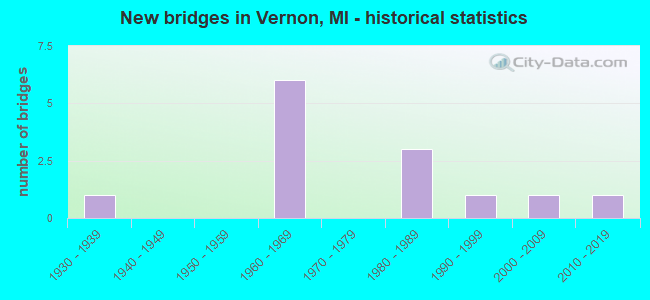
- New bridges - historical statistics
- 11930-1939
- 61960-1969
- 31980-1989
- 11990-1999
- 12000-2009
- 12010-2019


- Bridge Condition - Deck
- 11.1%Very good
- 33.3%Good
- 22.2%Satisfactory
- 22.2%Fair
- 11.1%Poor

- Bridge Condition - Superstructure
- 22.2%Very good
- 33.3%Good
- 11.1%Satisfactory
- 22.2%Fair
- 11.1%Poor

- Bridge Condition - Substructure
- 33.3%Very good
- 22.2%Good
- 44.4%Satisfactory

- Bridge Condition - Channel
- 11.1%Very good
- 55.6%Good
- 33.3%Satisfactory

- Bridge Condition - Culverts
- 50.0%Very good
- 50.0%Satisfactory
Find on map >> Show street view
Structure Number: 9743, Location: 0.6 MI SW OF M-71 (Lat: 42.924408, Lng: -84.011842), Route carried "on" structure: Interstate 69, Year Built: 1961, Year Reconstructed: 1998, Status: Open, Structure Length: 9.18m (30.12ft), Average Daily Traffic: 13,840 (year 2007), Truck Traffic: 22%, Average Future Daily Traffic: 19,072 (year 2018), Design Load: HS 20, Features Intersected: CN RR & REED RD
Minimum Vertical Clearance: 30.48m (100.00ft), Kilometerpoint: 32.571, Lanes on structure: 2, Lanes under structure: 2, Base Highway Network: Yes (Inventory Route: 55, Subroute: 9), Owner: State Highway Agency, Approaching Roadway Width: 14.0m (45.9ft), Skew: 13 degrees, Material/Design: Steel, Design/Construction: Stringer/Multi-beam, Number Of Spans In Main Unit: 6, Length of Maximum Span: 15.8m (51.8ft), Curb-To-Curb Width: 14.0m (45.9ft), Out-to-Out Width: 15.0m (49.2ft)
Condition: Deck: Satisfactory, Superstructure: Fair, Substructure: Satisfactory, Operating Rating: 80.6 metric tons, Method Used To Determine Operating Rating: Load Factor (LF), Inventory Rating: 48.3 metric tons, Method Used To Determine Inventory Rating: Load Factor (LF), Structural Evaluation: Somewhat better than minimum adequacy, Deck Geometry: Superior to present desirable criteria, Underclear: Equal to present minimum criteria, Approach Roadway Alignment: Equal to present desirable criteria, Designated Inspection Frequency: Every 24 months, Inspection Date: August 2021, Deck Structure Type: Concrete Cast-file-Place, Wearing Surface/Protective System: Wearing Surface: Monolithic Concrete, Deck Protection: Epoxy Coated Reinforcing
Find on map >> Show street view
Structure Number: 9751, Location: 1.5 MI SW OF M-71 (Lat: 42.919975, Lng: -84.027472), Route carried "on" structure: County highway , Year Built: 1966, Status: Open, Structure Length: 7.07m (23.20ft), Average Daily Traffic: 800 (year 1988), Average Future Daily Traffic: 690 (year 1977), Design Load: H 15, Features Intersected: I-69, Facility Carried by Structure: VERNON RD
Minimum Vertical Clearance: 30.48m (100.00ft), Kilometerpoint: 4.305, Lanes on structure: 2, Lanes under structure: 4, Owner: State Highway Agency, Approaching Roadway Width: 7.9m (25.9ft), Skew: 2 degrees, Material/Design: Steel, Design/Construction: Stringer/Multi-beam, Number Of Spans In Main Unit: 4, Length of Maximum Span: 23.9m (78.4ft), Curb or Sidewalk Widths: Left: 0.5m (1.6ft), Right: 0.5m (1.6ft), Curb-To-Curb Width: 8.5m (27.9ft), Out-to-Out Width: 10.2m (33.5ft)
Condition: Deck: Fair, Superstructure: Good, Substructure: Good, Operating Rating: 61.9 metric tons, Method Used To Determine Operating Rating: Load Factor (LF) rating reported by rating factor (RF) method using MS18 loading, Inventory Rating: 36.9 metric tons, Method Used To Determine Inventory Rating: Load Factor (LF) rating reported by rating factor (RF) method using MS18 loading, Structural Evaluation: Better than present minimum criteria, Deck Geometry: Somewhat better than minimum adequacy, Underclear: Somewhat better than minimum adequacy, Approach Roadway Alignment: Equal to present desirable criteria, Designated Inspection Frequency: Every 24 months, Inspection Date: August 2021, Bridge Improvement Cost: $204,000, Deck Structure Type: Concrete Cast-file-Place, Wearing Surface/Protective System: Wearing Surface: Epoxy Overlay
Find on map >> Show street view
Structure Number: 9768, Location: 2.3 MI NW OF M-78 (Lat: 42.946097, Lng: -84.036017), Route carried "on" structure: State highway 71, Year Built: 1931, Year Reconstructed: 1999, Status: Open, Structure Length: 3.38m (11.09ft), Average Daily Traffic: 6,379 (year 2007), Truck Traffic: 6%, Average Future Daily Traffic: 7,118 (year 2018), Design Load: HS 25 or greater, Features Intersected: SHIAWASSEE RIVER
Minimum Vertical Clearance: 30.48m (100.00ft), Kilometerpoint: 3.789, Lanes on structure: 2, Base Highway Network: Yes (Inventory Route: 55, Subroute: 3), Owner: State Highway Agency, Approaching Roadway Width: 13.4m (44.0ft), Skew: 1 degrees, Material/Design: Steel continuous, Design/Construction: Stringer/Multi-beam, Number Of Spans In Main Unit: 2, Length of Maximum Span: 16.7m (54.8ft), Curb-To-Curb Width: 13.1m (43.0ft), Out-to-Out Width: 14.2m (46.6ft)
Condition: Deck: Good, Superstructure: Good, Substructure: Satisfactory, Channel: Satisfactory, Operating Rating: 87.7 metric tons, Method Used To Determine Operating Rating: Load Factor (LF), Inventory Rating: 52.5 metric tons, Method Used To Determine Inventory Rating: Load Factor (LF), Structural Evaluation: Equal to present minimum criteria, Deck Geometry: Somewhat better than minimum adequacy, Waterway Adequacy: Equal to present desirable criteria, Approach Roadway Alignment: Equal to present desirable criteria, Designated Inspection Frequency: Every 24 months, Inspection Date: August 2021, Deck Structure Type: Concrete Cast-file-Place, Wearing Surface/Protective System: Wearing Surface: Monolithic Concrete, Deck Protection: Epoxy Coated Reinforcing
Find on map >> Show street view
Structure Number: 9791, Location: 2.5 MI W OF VERNON (Lat: 42.930458, Lng: -84.073972), Route carried "on" structure: County highway 7644, Year Built: 1985, Status: Open, Structure Length: 4.42m (14.50ft), Average Daily Traffic: 1,096 (year 2011), Truck Traffic: 10%, Average Future Daily Traffic: 1,980 (year 2031), Design Load: HS 20, Features Intersected: SHIAWASSEE RIVER, Facility Carried by Structure: BENNINGTON ROAD
Minimum Vertical Clearance: 30.48m (100.00ft), Kilometerpoint: 0.248, Lanes on structure: 2, Owner: County Highway Agency, Approaching Roadway Width: 11.0m (36.1ft), Skew: 1 degrees, Material/Design: Prestressed concrete, Design/Construction: Box Beam or Girders - Multiple, Number Of Spans In Main Unit: 2, Length of Maximum Span: 21.0m (68.9ft), Curb-To-Curb Width: 11.0m (36.1ft), Out-to-Out Width: 11.4m (37.4ft)
Condition: Deck: Fair, Superstructure: Fair, Substructure: Satisfactory, Channel: Good, Operating Rating: 82.9 metric tons, Method Used To Determine Operating Rating: Load Factor (LF) rating reported by rating factor (RF) method using MS18 loading, Inventory Rating: 49.6 metric tons, Method Used To Determine Inventory Rating: Load Factor (LF) rating reported by rating factor (RF) method using MS18 loading, Structural Evaluation: Somewhat better than minimum adequacy, Deck Geometry: Equal to present minimum criteria, Waterway Adequacy: Equal to present desirable criteria, Approach Roadway Alignment: Equal to present desirable criteria, Designated Inspection Frequency: Every 24 months, Inspection Date: May 2020, Deck Structure Type: Concrete Precast Panels, Wearing Surface/Protective System: Wearing Surface: Bituminous, Membrane: Preformed Fabric
Find on map >> Show street view
Structure Number: 9869, Location: 1.9 MI NE OF VERNON (Lat: 42.961953, Lng: -84.007111), Route carried "on" structure: County highway , Year Built: 1995, Status: Open, Structure Length: 2.44m (8.01ft), Average Daily Traffic: 47 (year 1998), Truck Traffic: 5%, Average Future Daily Traffic: 85 (year 2018), Design Load: HS 20, Features Intersected: WEBB CREEK, Facility Carried by Structure: REED RD
Minimum Vertical Clearance: 30.48m (100.00ft), Kilometerpoint: 6.550, Lanes on structure: 2, Owner: County Highway Agency, Approaching Roadway Width: 9.1m (29.9ft), Material/Design: Prestressed concrete, Design/Construction: Box Beam or Girders - Multiple, Number Of Spans In Main Unit: 1, Length of Maximum Span: 23.1m (75.8ft), Curb-To-Curb Width: 8.7m (28.5ft), Out-to-Out Width: 9.5m (31.2ft)
Condition: Deck: Good, Superstructure: Very good, Substructure: Very good, Channel: Very good, Operating Rating: 76.8 metric tons, Method Used To Determine Operating Rating: Load Factor (LF) rating reported by rating factor (RF) method using MS18 loading, Inventory Rating: 46.0 metric tons, Method Used To Determine Inventory Rating: Load Factor (LF) rating reported by rating factor (RF) method using MS18 loading, Structural Evaluation: Equal to present desirable criteria, Deck Geometry: Better than present minimum criteria, Waterway Adequacy: Equal to present desirable criteria, Approach Roadway Alignment: Equal to present desirable criteria, Designated Inspection Frequency: Every 24 months, Inspection Date: April 2020, Deck Structure Type: Concrete Precast Panels, Wearing Surface/Protective System: Wearing Surface: Monolithic Concrete, Deck Protection: Epoxy Coated Reinforcing
Find on map >> Show street view
Structure Number: 9874, Location: 0.5 MI NW OF VERNON (Lat: 42.942531, Lng: -84.036967), Route carried "on" structure: County highway , Year Built: 2000, Status: Open, Structure Length: 3.75m (12.30ft), Average Daily Traffic: 359 (year 2000), Truck Traffic: 2%, Average Future Daily Traffic: 533 (year 2019), Design Load: HS 20, Features Intersected: SHIAWASSEE RIVER, Facility Carried by Structure: PARMENTER RD
Minimum Vertical Clearance: 30.48m (100.00ft), Kilometerpoint: 7.836, Lanes on structure: 2, Owner: County Highway Agency, Approaching Roadway Width: 10.1m (33.1ft), Skew: 2 degrees, Material/Design: Prestressed concrete, Design/Construction: Box Beam or Girders - Multiple, Number Of Spans In Main Unit: 2, Length of Maximum Span: 18.8m (61.7ft), Curb-To-Curb Width: 11.0m (36.1ft), Out-to-Out Width: 11.5m (37.7ft)
Condition: Deck: Very good, Superstructure: Very good, Substructure: Very good, Channel: Good, Operating Rating: 68.0 metric tons, Method Used To Determine Operating Rating: Load Factor (LF) rating reported by rating factor (RF) method using MS18 loading, Inventory Rating: 40.8 metric tons, Method Used To Determine Inventory Rating: Load Factor (LF) rating reported by rating factor (RF) method using MS18 loading, Structural Evaluation: Equal to present desirable criteria, Deck Geometry: Equal to present desirable criteria, Waterway Adequacy: Better than present minimum criteria, Approach Roadway Alignment: Equal to present minimum criteria, Designated Inspection Frequency: Every 24 months, Inspection Date: May 2020, Deck Structure Type: Concrete Cast-file-Place, Wearing Surface/Protective System: Wearing Surface: Integral Concrete, Deck Protection: Epoxy Coated Reinforcing
Find on map >> Show street view
Structure Number: 9875, Location: 1 MI N 0.3 MI W OF VERNON (Lat: 42.950028, Lng: -84.033550), Route carried "on" structure: County highway , Year Built: 1989, Status: Open, Structure Length: 3.96m (12.99ft), Average Daily Traffic: 352 (year 2001), Truck Traffic: 5%, Average Future Daily Traffic: 523 (year 2021), Design Load: HS 20+Mod, Features Intersected: SHIAWASSEE RIVER, Facility Carried by Structure: GOODALL RD
Minimum Vertical Clearance: 30.48m (100.00ft), Kilometerpoint: 1.007, Lanes on structure: 2, Owner: County Highway Agency, Approaching Roadway Width: 10.1m (33.1ft), Skew: 1 degrees, Material/Design: Prestressed concrete, Design/Construction: Stringer/Multi-beam, Number Of Spans In Main Unit: 2, Length of Maximum Span: 18.9m (62.0ft), Curb-To-Curb Width: 10.1m (33.1ft), Out-to-Out Width: 11.2m (36.7ft)
Condition: Deck: Good, Superstructure: Good, Substructure: Very good, Channel: Good, Operating Rating: 60.6 metric tons, Method Used To Determine Operating Rating: Load and Resistance Factor Rating (LRFR) rating reported by rating factor(RF) method using HL-93 loadings, Inventory Rating: 46.0 metric tons, Method Used To Determine Inventory Rating: Load and Resistance Factor Rating (LRFR) rating reported by rating factor(RF) method using HL-93 loadings, Structural Evaluation: Better than present minimum criteria, Deck Geometry: Better than present minimum criteria, Waterway Adequacy: Superior to present desirable criteria, Approach Roadway Alignment: Equal to present desirable criteria, Designated Inspection Frequency: Every 24 months, Inspection Date: May 2020, Deck Structure Type: Concrete Cast-file-Place, Wearing Surface/Protective System: Wearing Surface: Monolithic Concrete, Deck Protection: Epoxy Coated Reinforcing
Find on map >> Show street view
Structure Number: 9893, Location: IN THE VILLAGE OF VERNON (Lat: 42.939111, Lng: -84.036303), Route carried "on" structure: City street , Year Built: 1965, Status: Open, Structure Length: 1.09m (3.58ft), Average Daily Traffic: 1,209 (year 2010), Truck Traffic: 2%, Average Future Daily Traffic: 1,600 (year 2020), Design Load: HS 20+Mod, Features Intersected: HOLLY DRAIN, Facility Carried by Structure: MAIN ST
Minimum Vertical Clearance: 30.48m (100.00ft), Kilometerpoint: 3.587, Lanes on structure: 2, Owner: City or Municipal Highway Agency, Approaching Roadway Width: 9.1m (29.9ft), Material/Design: Prestressed concrete, Design/Construction: Box Beam or Girders - Multiple, Number Of Spans In Main Unit: 1, Length of Maximum Span: 10.0m (32.8ft), Curb or Sidewalk Widths: Left: 0.4m (1.3ft), Right: 0.4m (1.3ft), Curb-To-Curb Width: 8.8m (28.9ft), Out-to-Out Width: 10.4m (34.1ft)
Condition: Deck: Poor, Superstructure: Poor, Substructure: Satisfactory, Channel: Satisfactory, Operating Rating: 52.5 metric tons, Method Used To Determine Operating Rating: Load Factor (LF) rating reported by rating factor (RF) method using MS18 loading, Inventory Rating: 31.4 metric tons, Method Used To Determine Inventory Rating: Load Factor (LF) rating reported by rating factor (RF) method using MS18 loading, Structural Evaluation: Meets minimum limits, Deck Geometry: Somewhat better than minimum adequacy, Waterway Adequacy: Better than present minimum criteria, Approach Roadway Alignment: Equal to present desirable criteria, Designated Inspection Frequency: Every 24 months, Inspection Date: August 2020, Deck Structure Type: Concrete Precast Panels, Wearing Surface/Protective System: Wearing Surface: Bituminous
Find on map >> Show street view
Structure Number: 9894, Location: IN THE VILLAGE OF VERNON (Lat: 42.935414, Lng: -84.027925), Route carried "on" structure: City street , Year Built: 1965, Status: Open, Structure Length: 1.12m (3.67ft), Average Daily Traffic: 500 (year 0000), Truck Traffic: 2%, Average Future Daily Traffic: 950 (year 1998), Design Load: HS 20+Mod, Features Intersected: HOLLY DRAIN, Facility Carried by Structure: MAPLE STREET
Minimum Vertical Clearance: 30.48m (100.00ft), Kilometerpoint: 6.035, Lanes on structure: 2, Owner: City or Municipal Highway Agency, Approaching Roadway Width: 7.6m (24.9ft), Material/Design: Prestressed concrete, Design/Construction: Box Beam or Girders - Multiple, Number Of Spans In Main Unit: 1, Length of Maximum Span: 10.6m (34.8ft), Curb-To-Curb Width: 7.2m (23.6ft), Out-to-Out Width: 7.5m (24.6ft)
Condition: Deck: Satisfactory, Superstructure: Satisfactory, Substructure: Good, Channel: Satisfactory, Operating Rating: 51.5 metric tons, Method Used To Determine Operating Rating: Load Factor (LF) rating reported by rating factor (RF) method using MS18 loading, Inventory Rating: 30.8 metric tons, Method Used To Determine Inventory Rating: Load Factor (LF) rating reported by rating factor (RF) method using MS18 loading, Structural Evaluation: Equal to present minimum criteria, Deck Geometry: Meets minimum limits, Waterway Adequacy: Better than present minimum criteria, Approach Roadway Alignment: Equal to present desirable criteria, Designated Inspection Frequency: Every 24 months, Inspection Date: August 2020, Deck Structure Type: Concrete Precast Panels, Wearing Surface/Protective System: Wearing Surface: Bituminous
Find on map >> Show street view
Structure Number: 9895, Location: IN THE VILLAGE OF VERNON (Lat: 42.937189, Lng: -84.033164), Route carried "on" structure: City street , Year Built: 1987, Status: Open, Structure Length: 1.37m (4.49ft), Average Daily Traffic: 90 (year 0000), Truck Traffic: 2%, Average Future Daily Traffic: 170 (year 1998), Design Load: HS 20+Mod, Features Intersected: HOLLY DRAIN, Facility Carried by Structure: WALNUT STREET
Minimum Vertical Clearance: 30.48m (100.00ft), Kilometerpoint: 0.671, Lanes on structure: 2, Owner: City or Municipal Highway Agency, Approaching Roadway Width: 8.5m (27.9ft), Material/Design: Concrete, Design/Construction: Culvert, Number Of Spans In Main Unit: 2, Length of Maximum Span: 6.1m (20.0ft), Curb or Sidewalk Widths: Left: 1.2m (3.9ft), Right: 0.9m (3.0ft), Curb-To-Curb Width: 8.5m (27.9ft), Out-to-Out Width: 10.9m (35.8ft)
Condition: Channel: Good, Culverts: Satisfactory, Operating Rating: 34.3 metric tons, Method Used To Determine Operating Rating: Load Factor (LF) rating reported by rating factor (RF) method using MS18 loading, Inventory Rating: 20.7 metric tons, Method Used To Determine Inventory Rating: Load Factor (LF) rating reported by rating factor (RF) method using MS18 loading, Structural Evaluation: Equal to present minimum criteria, Deck Geometry: Better than present minimum criteria, Waterway Adequacy: Better than present minimum criteria, Approach Roadway Alignment: Equal to present desirable criteria, Designated Inspection Frequency: Every 24 months, Inspection Date: August 2020, Deck Structure Type: Concrete Precast Panels, Wearing Surface/Protective System: Wearing Surface: Bituminous
Find on map >> Show street view
Structure Number: 12974, Location: VENICE TWP SEC 21 (Lat: 42.984906, Lng: -83.994403), Route carried "on" structure: County highway , Year Built: 2012, Status: Open, Structure Length: 1.17m (3.84ft), Average Daily Traffic: 304 (year 2011), Truck Traffic: 2%, Average Future Daily Traffic: 452 (year 2031), Design Load: Greater than HL93, Features Intersected: RUSH BED CREEK, Facility Carried by Structure: LENNON ROAD
Minimum Vertical Clearance: 30.48m (100.00ft), Kilometerpoint: 2.646, Lanes on structure: 2, Owner: County Highway Agency, Approaching Roadway Width: 9.1m (29.9ft), Material/Design: Concrete, Design/Construction: Culvert, Number Of Spans In Main Unit: 1, Length of Maximum Span: 11.0m (36.1ft), Curb-To-Curb Width: 9.1m (29.9ft), Out-to-Out Width: 12.2m (40.0ft)
Condition: Channel: Good, Culverts: Very good, Operating Rating: 64.8 metric tons, Method Used To Determine Operating Rating: Load and Resistance Factor Rating (LRFR) rating reported by rating factor(RF) method using HL-93 loadings, Inventory Rating: 48.6 metric tons, Method Used To Determine Inventory Rating: Load and Resistance Factor Rating (LRFR) rating reported by rating factor(RF) method using HL-93 loadings, Structural Evaluation: Equal to present desirable criteria, Waterway Adequacy: Equal to present desirable criteria, Approach Roadway Alignment: Meets minimum limits, Designated Inspection Frequency: Every 24 months, Inspection Date: May 2020, Deck Structure Type: Concrete Precast Panels, Wearing Surface/Protective System: Wearing Surface: Bituminous
Find on map >> Show street view
Structure Number: 9743, Location: 0.6 MI SW OF M-71 (Lat: 42.924408, Lng: -84.011842), Route carried "under" structure: County highway , Year Built: 1961, Structure Length: 0. m, Average Daily Traffic: 30 (year 1999), Features Intersected: CN RR & REED RD, Facility Carried by Structure: I-69 WB
Minimum Vertical Clearance: 7.37m (24.18ft), Kilometerpoint: 8.424, Lanes on structure: 2, Lanes under structure: 2, Material/Design: Steel, Design/Construction: Stringer/Multi-beam, Length of Maximum Span: 15.8m (51.8ft)
Find on map >> Show street view
Structure Number: 9751, Location: 1.5 MI SW OF M-71 (Lat: 42.919975, Lng: -84.027472), Route carried "under" structure: Interstate 69, Year Built: 1966, Structure Length: 0. m, Average Daily Traffic: 27,680 (year 2007), Truck Traffic: 22%, Features Intersected: I-69, Facility Carried by Structure: VERNON RD
Minimum Vertical Clearance: 5.05m (16.57ft), Kilometerpoint: 31.216, Lanes on structure: 2, Lanes under structure: 4, Material/Design: Steel, Design/Construction: Stringer/Multi-beam, Length of Maximum Span: 23.9m (78.4ft)