Bridge Statistics for Veneta, Oregon (OR)
Condition, Traffic, Stress, Structural Evaluation, Project Costs
- National Bridge Inventory (NBI) Statistics
- 18Number of bridges
- 177ft / 53.8mTotal length
- 80,349Total average daily traffic
- 16,627Total average daily truck traffic
- 89,501Total future (year 2025) average daily traffic
- National Bridge Inventory (NBI) Registered Bridges for Veneta
- No street view available for this location
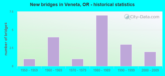
- New bridges - historical statistics
- 11950-1959
- 41960-1969
- 11970-1979
- 71980-1989
- 31990-1999
- 22000-2009


- Bridge Condition - Deck
- 11.8%Very good
- 70.6%Good
- 17.6%Satisfactory

- Bridge Condition - Superstructure
- 11.8%Very good
- 64.7%Good
- 23.5%Satisfactory

- Bridge Condition - Substructure
- 47.1%Good
- 47.1%Satisfactory
- 5.9%Fair

- Bridge Condition - Channel
- 29.4%Very good
- 35.3%Good
- 29.4%Satisfactory
- 5.9%Fair
Find on map >> Show street view
Structure Number: 1699A200 01898, Location: 00.5 N JCT HWY 62 (Lat: 44.061500, Lng: -123.354800), Route carried "on" structure: State highway 200, Year Built: 1966, Status: Open, Structure Length: 1.69m (5.54ft), Average Daily Traffic: 1,376 (year 2020), Truck Traffic: 20%, Average Future Daily Traffic: 1,700 (year 2040), Design Load: HS 20, Features Intersected: LONG TOM OFLOW
Minimum Vertical Clearance: 30+ m (98+ ft), Kilometerpoint: 30.545, Lanes on structure: 2, Base Highway Network: Yes, Owner: State Highway Agency, Approaching Roadway Width: 12.0m (39.4ft), Material/Design: Prestressed concrete, Design/Construction: Slab, Number Of Spans In Main Unit: 2, Length of Maximum Span: 8.5m (27.9ft), Curb-To-Curb Width: 12.0m (39.4ft), Out-to-Out Width: 12.2m (40.0ft)
Condition: Deck: Satisfactory, Superstructure: Satisfactory, Substructure: Satisfactory, Channel: Good, Operating Rating: 25.6 metric tons, Method Used To Determine Operating Rating: Load and Resistance Factor Rating (LRFR) rating reported by rating factor(RF) method using HL-93 loadings, Inventory Rating: 19.8 metric tons, Method Used To Determine Inventory Rating: Load and Resistance Factor Rating (LRFR) rating reported by rating factor(RF) method using HL-93 loadings, Structural Evaluation: Somewhat better than minimum adequacy, Deck Geometry: Equal to present minimum criteria, Waterway Adequacy: Equal to present desirable criteria, Approach Roadway Alignment: Equal to present desirable criteria, Designated Inspection Frequency: Every 24 months, Inspection Date: October 2021, Deck Structure Type: Concrete Precast Panels, Wearing Surface/Protective System: Wearing Surface: Bituminous
Find on map >> Show street view
Structure Number: 1700A200 01928, Location: 00.2 N JCT HWY 062 (Lat: 44.056861, Lng: -123.352986), Route carried "on" structure: State highway 200, Year Built: 1967, Status: Open, Structure Length: 10.63m (34.88ft), Average Daily Traffic: 1,376 (year 2020), Truck Traffic: 20%, Average Future Daily Traffic: 1,700 (year 2040), Design Load: HS 20, Features Intersected: LONG TOM OFLOW
Minimum Vertical Clearance: 30+ m (98+ ft), Kilometerpoint: 31.028, Lanes on structure: 2, Base Highway Network: Yes, Owner: State Highway Agency, Approaching Roadway Width: 12.0m (39.4ft), Material/Design: Prestressed concrete, Design/Construction: Slab, Number Of Spans In Main Unit: 7, Length of Maximum Span: 15.2m (49.9ft), Curb-To-Curb Width: 12.0m (39.4ft), Out-to-Out Width: 12.2m (40.0ft)
Condition: Deck: Satisfactory, Superstructure: Satisfactory, Substructure: Satisfactory, Channel: Good, Operating Rating: 23.0 metric tons, Method Used To Determine Operating Rating: Load and Resistance Factor Rating (LRFR) rating reported by rating factor(RF) method using HL-93 loadings, Inventory Rating: 17.8 metric tons, Method Used To Determine Inventory Rating: Load and Resistance Factor Rating (LRFR) rating reported by rating factor(RF) method using HL-93 loadings, Structural Evaluation: Meets minimum limits, Deck Geometry: Equal to present minimum criteria, Waterway Adequacy: Equal to present desirable criteria, Approach Roadway Alignment: Equal to present desirable criteria, Designated Inspection Frequency: Every 24 months, Inspection Date: October 2021, Deck Structure Type: Concrete Precast Panels, Wearing Surface/Protective System: Wearing Surface: Bituminous
Find on map >> Show street view
Structure Number: 2520A062 05091, Location: 050 MI W EUGENE WCL (Lat: 44.052647, Lng: -123.268628), Route carried "on" structure: State highway 126, Year Built: 1984, Status: Open, Structure Length: 3.23m (10.60ft), Average Daily Traffic: 13,446 (year 2020), Truck Traffic: 22%, Average Future Daily Traffic: 14,600 (year 2040), Design Load: HS 25 or greater, Features Intersected: COYOTE CREEK
Minimum Vertical Clearance: 30+ m (98+ ft), Kilometerpoint: 81.932, Lanes on structure: 2, Base Highway Network: Yes, Owner: State Highway Agency, Approaching Roadway Width: 13.2m (43.3ft), Skew: 3 degrees, Material/Design: Prestressed concrete, Design/Construction: Slab, Number Of Spans In Main Unit: 3, Length of Maximum Span: 10.8m (35.4ft), Curb-To-Curb Width: 13.2m (43.3ft), Out-to-Out Width: 13.4m (44.0ft)
Condition: Deck: Good, Superstructure: Good, Substructure: Satisfactory, Channel: Very good, Operating Rating: 35.3 metric tons, Method Used To Determine Operating Rating: Load and Resistance Factor Rating (LRFR) rating reported by rating factor(RF) method using HL-93 loadings, Inventory Rating: 27.2 metric tons, Method Used To Determine Inventory Rating: Load and Resistance Factor Rating (LRFR) rating reported by rating factor(RF) method using HL-93 loadings, Structural Evaluation: Equal to present minimum criteria, Deck Geometry: Somewhat better than minimum adequacy, Waterway Adequacy: Equal to present desirable criteria, Approach Roadway Alignment: Equal to present desirable criteria, Designated Inspection Frequency: Every 24 months, Underwater Inspection Frequency: Every 60 months, Inspection Date: October 2021, Underwater Inspection Date: Febuary 2020, Deck Structure Type: Concrete Precast Panels, Wearing Surface/Protective System: Wearing Surface: Bituminous, Membrane: Preformed Fabric
Find on map >> Show street view
Structure Number: 2522A062 04993, Location: 059 MI W EUGENE WCL (Lat: 44.052681, Lng: -123.288444), Route carried "on" structure: State highway 126, Year Built: 1984, Status: Open, Structure Length: 3.47m (11.38ft), Average Daily Traffic: 13,446 (year 2020), Truck Traffic: 22%, Average Future Daily Traffic: 14,600 (year 2040), Design Load: HS 25 or greater, Features Intersected: MIDDLE FK COYOTE CREEK
Minimum Vertical Clearance: 30+ m (98+ ft), Kilometerpoint: 80.355, Lanes on structure: 2, Base Highway Network: Yes, Owner: State Highway Agency, Approaching Roadway Width: 13.2m (43.3ft), Material/Design: Prestressed concrete, Design/Construction: Slab, Number Of Spans In Main Unit: 3, Length of Maximum Span: 11.6m (38.1ft), Curb-To-Curb Width: 13.2m (43.3ft), Out-to-Out Width: 13.4m (44.0ft)
Condition: Deck: Good, Superstructure: Good, Substructure: Satisfactory, Channel: Very good, Operating Rating: 36.9 metric tons, Method Used To Determine Operating Rating: Load and Resistance Factor Rating (LRFR) rating reported by rating factor(RF) method using HL-93 loadings, Inventory Rating: 28.5 metric tons, Method Used To Determine Inventory Rating: Load and Resistance Factor Rating (LRFR) rating reported by rating factor(RF) method using HL-93 loadings, Structural Evaluation: Equal to present minimum criteria, Deck Geometry: Somewhat better than minimum adequacy, Waterway Adequacy: Equal to present desirable criteria, Approach Roadway Alignment: Equal to present desirable criteria, Designated Inspection Frequency: Every 24 months, Inspection Date: October 2021, Deck Structure Type: Concrete Precast Panels, Wearing Surface/Protective System: Wearing Surface: Bituminous, Membrane: Built-up
Find on map >> Show street view
Structure Number: 4050A200 01872, Location: 00.8 N JCT HWY 62 (Lat: 44.064933, Lng: -123.355589), Route carried "on" structure: State highway 200, Year Built: 1966, Status: Open, Structure Length: 4.42m (14.50ft), Average Daily Traffic: 1,376 (year 2020), Truck Traffic: 20%, Average Future Daily Traffic: 1,700 (year 2040), Design Load: HS 20, Features Intersected: LONG TOM RIVER
Minimum Vertical Clearance: 30+ m (98+ ft), Kilometerpoint: 30.127, Lanes on structure: 2, Base Highway Network: Yes, Owner: State Highway Agency, Approaching Roadway Width: 12.0m (39.4ft), Skew: 2 degrees, Material/Design: Concrete continuous, Design/Construction: Slab, Number Of Spans In Main Unit: 3, Length of Maximum Span: 17.7m (58.1ft), Curb-To-Curb Width: 12.0m (39.4ft), Out-to-Out Width: 12.2m (40.0ft)
Condition: Deck: Good, Superstructure: Good, Substructure: Satisfactory, Channel: Satisfactory, Operating Rating: 72.3 metric tons, Method Used To Determine Operating Rating: Load and Resistance Factor Rating (LRFR) rating reported by rating factor(RF) method using HL-93 loadings, Inventory Rating: 55.7 metric tons, Method Used To Determine Inventory Rating: Load and Resistance Factor Rating (LRFR) rating reported by rating factor(RF) method using HL-93 loadings, Structural Evaluation: Equal to present minimum criteria, Deck Geometry: Equal to present minimum criteria, Waterway Adequacy: Equal to present desirable criteria, Approach Roadway Alignment: Equal to present desirable criteria, Designated Inspection Frequency: Every 24 months, Underwater Inspection Frequency: Every 60 months, Inspection Date: October 2021, Underwater Inspection Date: December 2019, Deck Structure Type: Concrete Cast-file-Place, Wearing Surface/Protective System: Wearing Surface: Bituminous
Find on map >> Show street view
Structure Number: 7271 200 02549, Location: 060 M S JCT HWY 62 (Lat: 43.976733, Lng: -123.322369), Route carried "on" structure: State highway 200, Year Built: 1955, Status: Open, Structure Length: 5.55m (18.21ft), Average Daily Traffic: 1,376 (year 2020), Truck Traffic: 20%, Average Future Daily Traffic: 1,700 (year 2040), Design Load: HS 20, Features Intersected: COYOTE CREEK
Minimum Vertical Clearance: 30+ m (98+ ft), Kilometerpoint: 41.022, Lanes on structure: 2, Owner: State Highway Agency, Approaching Roadway Width: 7.9m (25.9ft), Material/Design: Concrete continuous, Design/Construction: Tee Beam, Number Of Spans In Main Unit: 3, Length of Maximum Span: 21.3m (69.9ft), Curb-To-Curb Width: 7.9m (25.9ft), Out-to-Out Width: 9.4m (30.8ft)
Condition: Deck: Satisfactory, Superstructure: Satisfactory, Substructure: Satisfactory, Channel: Satisfactory, Operating Rating: 44.5 metric tons, Method Used To Determine Operating Rating: Load Factor (LF), Inventory Rating: 27.2 metric tons, Method Used To Determine Inventory Rating: Load Factor (LF), Structural Evaluation: Equal to present minimum criteria, Deck Geometry: Meets minimum limits, Waterway Adequacy: Equal to present desirable criteria, Approach Roadway Alignment: Equal to present desirable criteria, Designated Inspection Frequency: Every 24 months, Underwater Inspection Frequency: Every 60 months, Inspection Date: October 2021, Underwater Inspection Date: March 2021, Deck Structure Type: Concrete Cast-file-Place, Wearing Surface/Protective System: Wearing Surface: Bituminous
Find on map >> Show street view
Structure Number: M594 062 0473, Location: 005 MI W OF HWY 200 JCT (Lat: 44.053700, Lng: -123.361100), Route carried "on" structure: State highway 126, Year Built: 1988, Year Reconstructed: 2002, Status: Open, Structure Length: 0.64m (2.10ft), Average Daily Traffic: 6,972 (year 2020), Truck Traffic: 22%, Average Future Daily Traffic: 8,500 (year 2040), Design Load: HS 20+Mod, Features Intersected: FIELD DRAINAGE
Minimum Vertical Clearance: 30+ m (98+ ft), Kilometerpoint: 74.786, Lanes on structure: 2, Base Highway Network: Yes, Owner: State Highway Agency, Approaching Roadway Width: 12.2m (40.0ft), Material/Design: Concrete continuous, Design/Construction: Culvert, Number Of Spans In Main Unit: 2, Length of Maximum Span: 3.0m (9.8ft)
Condition: Channel: Good, Culverts: Satisfactory, Operating Rating: 62.5 metric tons, Method Used To Determine Operating Rating: Load and Resistance Factor Rating (LRFR) rating reported by rating factor(RF) method using HL-93 loadings, Inventory Rating: 48.3 metric tons, Method Used To Determine Inventory Rating: Load and Resistance Factor Rating (LRFR) rating reported by rating factor(RF) method using HL-93 loadings, Structural Evaluation: Equal to present minimum criteria, Waterway Adequacy: Equal to present desirable criteria, Approach Roadway Alignment: Equal to present desirable criteria, Designated Inspection Frequency: Every 24 months, Inspection Date: June 2021
Find on map >> Show street view
Structure Number: 16199 062 04538, Location: 024 MI W OF JCT HWY 200 (Lat: 44.049800, Lng: -123.398900), Route carried "on" structure: State highway 126, Year Built: 1988, Status: Open, Structure Length: 6.04m (19.82ft), Average Daily Traffic: 6,400 (year 2020), Truck Traffic: 22%, Average Future Daily Traffic: 6,800 (year 2040), Design Load: HS 25 or greater, Features Intersected: LONG TOM RIVER OVERFLOW
Minimum Vertical Clearance: 30+ m (98+ ft), Kilometerpoint: 71.712, Lanes on structure: 2, Base Highway Network: Yes, Owner: State Highway Agency, Approaching Roadway Width: 12.5m (41.0ft), Material/Design: Prestressed concrete, Design/Construction: Slab, Number Of Spans In Main Unit: 3, Length of Maximum Span: 20.1m (65.9ft), Curb-To-Curb Width: 12.5m (41.0ft), Out-to-Out Width: 13.4m (44.0ft)
Condition: Deck: Good, Superstructure: Good, Substructure: Satisfactory, Channel: Very good, Operating Rating: 49.2 metric tons, Method Used To Determine Operating Rating: Load and Resistance Factor Rating (LRFR) rating reported by rating factor(RF) method using HL-93 loadings, Inventory Rating: 37.9 metric tons, Method Used To Determine Inventory Rating: Load and Resistance Factor Rating (LRFR) rating reported by rating factor(RF) method using HL-93 loadings, Structural Evaluation: Equal to present minimum criteria, Deck Geometry: Somewhat better than minimum adequacy, Waterway Adequacy: Equal to present desirable criteria, Approach Roadway Alignment: Equal to present desirable criteria, Designated Inspection Frequency: Every 24 months, Inspection Date: June 2021, Deck Structure Type: Concrete Precast Panels, Wearing Surface/Protective System: Wearing Surface: Bituminous, Membrane: Preformed Fabric
Find on map >> Show street view
Structure Number: 16200 062 04673, Location: 011 MI W OF HWY 200 JCT (Lat: 44.051800, Lng: -123.372100), Route carried "on" structure: State highway 126, Year Built: 1988, Status: Open, Structure Length: 2.13m (6.99ft), Average Daily Traffic: 6,972 (year 2020), Truck Traffic: 22%, Average Future Daily Traffic: 8,500 (year 2040), Design Load: HS 25 or greater, Features Intersected: LONG TOM RIVER
Minimum Vertical Clearance: 30+ m (98+ ft), Kilometerpoint: 73.869, Lanes on structure: 2, Base Highway Network: Yes, Owner: State Highway Agency, Approaching Roadway Width: 12.5m (41.0ft), Material/Design: Prestressed concrete, Design/Construction: Slab, Number Of Spans In Main Unit: 1, Length of Maximum Span: 21.3m (69.9ft), Curb-To-Curb Width: 12.5m (41.0ft), Out-to-Out Width: 13.4m (44.0ft)
Condition: Deck: Good, Superstructure: Good, Substructure: Good, Channel: Satisfactory, Operating Rating: 62.9 metric tons, Method Used To Determine Operating Rating: Load and Resistance Factor Rating (LRFR) rating reported by rating factor(RF) method using HL-93 loadings, Inventory Rating: 48.6 metric tons, Method Used To Determine Inventory Rating: Load and Resistance Factor Rating (LRFR) rating reported by rating factor(RF) method using HL-93 loadings, Structural Evaluation: Better than present minimum criteria, Deck Geometry: Somewhat better than minimum adequacy, Waterway Adequacy: Equal to present desirable criteria, Approach Roadway Alignment: Equal to present desirable criteria, Designated Inspection Frequency: Every 24 months, Inspection Date: June 2021, Deck Structure Type: Concrete Precast Panels, Wearing Surface/Protective System: Wearing Surface: Bituminous, Membrane: Preformed Fabric
Find on map >> Show street view
Structure Number: 16649 062 04628, Location: 016 MI W OF JCT HWY 200 (Lat: 44.051300, Lng: -123.381100), Route carried "on" structure: State highway 126, Year Built: 1988, Status: Open, Structure Length: 2.01m (6.59ft), Average Daily Traffic: 6,972 (year 2020), Truck Traffic: 22%, Average Future Daily Traffic: 8,500 (year 2040), Design Load: HS 25 or greater, Features Intersected: LONG TOM RIVER OVERFLOW
Minimum Vertical Clearance: 30+ m (98+ ft), Kilometerpoint: 73.145, Lanes on structure: 2, Base Highway Network: Yes, Owner: State Highway Agency, Approaching Roadway Width: 12.0m (39.4ft), Material/Design: Prestressed concrete, Design/Construction: Slab, Number Of Spans In Main Unit: 1, Length of Maximum Span: 20.1m (65.9ft), Curb-To-Curb Width: 12.0m (39.4ft), Out-to-Out Width: 12.6m (41.3ft)
Condition: Deck: Good, Superstructure: Good, Substructure: Good, Channel: Very good, Operating Rating: 41.1 metric tons, Method Used To Determine Operating Rating: Load and Resistance Factor Rating (LRFR) rating reported by rating factor(RF) method using HL-93 loadings, Inventory Rating: 31.8 metric tons, Method Used To Determine Inventory Rating: Load and Resistance Factor Rating (LRFR) rating reported by rating factor(RF) method using HL-93 loadings, Structural Evaluation: Better than present minimum criteria, Deck Geometry: Somewhat better than minimum adequacy, Waterway Adequacy: Equal to present desirable criteria, Approach Roadway Alignment: Equal to present desirable criteria, Designated Inspection Frequency: Every 24 months, Inspection Date: June 2021, Deck Structure Type: Concrete Precast Panels, Wearing Surface/Protective System: Wearing Surface: Bituminous, Membrane: Preformed Fabric
Find on map >> Show street view
Structure Number: 17410 062 04889, Location: 00.4 MI W JCT HWY 200 (Lat: 44.052706, Lng: -123.309753), Route carried "on" structure: State highway 126, Year Built: 1996, Status: Open, Structure Length: 2.13m (6.99ft), Average Daily Traffic: 13,836 (year 2020), Truck Traffic: 22%, Average Future Daily Traffic: 13,900 (year 2040), Design Load: HS 25 or greater, Features Intersected: W FORK COYOTE CREEK
Minimum Vertical Clearance: 30+ m (98+ ft), Kilometerpoint: 78.681, Lanes on structure: 2, Base Highway Network: Yes, Owner: State Highway Agency, Approaching Roadway Width: 13.8m (45.3ft), Skew: 2 degrees, Material/Design: Prestressed concrete, Design/Construction: Slab, Number Of Spans In Main Unit: 1, Length of Maximum Span: 21.3m (69.9ft), Curb-To-Curb Width: 13.8m (45.3ft), Out-to-Out Width: 14.6m (47.9ft)
Condition: Deck: Good, Superstructure: Good, Substructure: Good, Channel: Very good, Operating Rating: 62.2 metric tons, Method Used To Determine Operating Rating: Load and Resistance Factor Rating (LRFR) rating reported by rating factor(RF) method using HL-93 loadings, Inventory Rating: 48.0 metric tons, Method Used To Determine Inventory Rating: Load and Resistance Factor Rating (LRFR) rating reported by rating factor(RF) method using HL-93 loadings, Structural Evaluation: Better than present minimum criteria, Deck Geometry: Superior to present desirable criteria, Waterway Adequacy: Equal to present desirable criteria, Approach Roadway Alignment: Equal to present desirable criteria, Designated Inspection Frequency: Every 24 months, Inspection Date: October 2021, Deck Structure Type: Concrete Precast Panels, Wearing Surface/Protective System: Wearing Surface: Bituminous, Membrane: Preformed Fabric, Deck Protection: Epoxy Coated Reinforcing
Find on map >> Show street view
Structure Number: 18404 406600198, Location: T18S-R5W-S4 (Lat: 44.037111, Lng: -123.312550), Route carried "on" structure: County highway C4066, Year Built: 1996, Status: Open, Structure Length: 1.40m (4.59ft), Average Daily Traffic: 1,384 (year 2020), Truck Traffic: 10%, Average Future Daily Traffic: 1,414 (year 2025), Design Load: HS 25 or greater, Features Intersected: SOIL CONS SERVE CHANNEL, Facility Carried by Structure: PERKINS RD
Minimum Vertical Clearance: 30+ m (98+ ft), Kilometerpoint: 3.193, Lanes on structure: 2, Owner: County Highway Agency, Approaching Roadway Width: 8.2m (26.9ft), Material/Design: Prestressed concrete, Design/Construction: Slab, Number Of Spans In Main Unit: 1, Length of Maximum Span: 13.7m (44.9ft), Curb-To-Curb Width: 8.4m (27.6ft), Out-to-Out Width: 8.5m (27.9ft)
Condition: Deck: Good, Superstructure: Good, Substructure: Good, Channel: Good, Operating Rating: 69.9 metric tons, Method Used To Determine Operating Rating: Load Factor (LF), Inventory Rating: 41.7 metric tons, Method Used To Determine Inventory Rating: Load Factor (LF), Structural Evaluation: Better than present minimum criteria, Deck Geometry: Meets minimum limits, Waterway Adequacy: Equal to present desirable criteria, Approach Roadway Alignment: Equal to present desirable criteria, Designated Inspection Frequency: Every 24 months, Inspection Date: October 2020, Deck Structure Type: Other, Wearing Surface/Protective System: Wearing Surface: Bituminous
Find on map >> Show street view
Structure Number: 18606 406692402, Location: 1 MI W JCT OF CENTRAL RD (Lat: 44.037150, Lng: -123.320889), Route carried "on" structure: County highway C4066, Year Built: 1996, Status: Open, Structure Length: 2.19m (7.19ft), Average Daily Traffic: 1,996 (year 2020), Truck Traffic: 5%, Average Future Daily Traffic: 2,296 (year 2025), Design Load: HS 20, Features Intersected: SCS CHANNEL, Facility Carried by Structure: PERKINS RD
Minimum Vertical Clearance: 30+ m (98+ ft), Kilometerpoint: 2.515, Lanes on structure: 2, Owner: County Highway Agency, Approaching Roadway Width: 7.9m (25.9ft), Skew: 2 degrees, Material/Design: Prestressed concrete, Design/Construction: Slab, Number Of Spans In Main Unit: 1, Length of Maximum Span: 21.6m (70.9ft), Curb-To-Curb Width: 8.4m (27.6ft), Out-to-Out Width: 8.5m (27.9ft)
Condition: Deck: Very good, Superstructure: Very good, Substructure: Good, Channel: Satisfactory, Operating Rating: 71.7 metric tons, Method Used To Determine Operating Rating: Load Factor (LF), Inventory Rating: 42.6 metric tons, Method Used To Determine Inventory Rating: Load Factor (LF), Structural Evaluation: Better than present minimum criteria, Deck Geometry: Meets minimum limits, Waterway Adequacy: Equal to present desirable criteria, Approach Roadway Alignment: Equal to present desirable criteria, Designated Inspection Frequency: Every 24 months, Inspection Date: October 2020, Deck Structure Type: Other, Wearing Surface/Protective System: Wearing Surface: Bituminous
Find on map >> Show street view
Structure Number: 19611, Location: 0.12 MI S OF OR 126 (Lat: 44.052031, Lng: -123.360169), Route carried "on" structure: City street , Year Built: 2002, Status: Open, Structure Length: 1.18m (3.87ft), Average Daily Traffic: 59 (year 2020), Truck Traffic: 5%, Average Future Daily Traffic: 64 (year 2025), Design Load: HS 25 or greater, Features Intersected: SPRR, Facility Carried by Structure: 8TH ST
Minimum Vertical Clearance: 30+ m (98+ ft), Kilometerpoint: 0.016, Lanes on structure: 2, Owner: City or Municipal Highway Agency, Approaching Roadway Width: 11.0m (36.1ft), Material/Design: Prestressed concrete, Design/Construction: Slab, Number Of Spans In Main Unit: 1, Length of Maximum Span: 11.6m (38.1ft), Curb or Sidewalk Widths: Left: 0.0m, Right: 1.8m (5.9ft), Curb-To-Curb Width: 11.0m (36.1ft), Out-to-Out Width: 13.5m (44.3ft)
Condition: Deck: Good, Superstructure: Good, Substructure: Good, Operating Rating: 72.6 metric tons, Method Used To Determine Operating Rating: Load Factor (LF), Inventory Rating: 43.5 metric tons, Method Used To Determine Inventory Rating: Load Factor (LF), Structural Evaluation: Better than present minimum criteria, Deck Geometry: Superior to present desirable criteria, Underclear: Equal to present minimum criteria, Approach Roadway Alignment: Better than present minimum criteria, Designated Inspection Frequency: Every 24 months, Inspection Date: October 2020, Deck Structure Type: Other, Wearing Surface/Protective System: Wearing Surface: Bituminous
Find on map >> Show street view
Structure Number: 20921 000 0002, Location: 0.20 MI S OF PERKINS ROAD (Lat: 44.034711, Lng: -123.325100), Route carried "on" structure: Other road , Year Built: 2008, Status: Open, Structure Length: 1.66m (5.45ft), Average Daily Traffic: 46 (year 2020), Truck Traffic: 1%, Average Future Daily Traffic: 51 (year 2025), Design Load: HL 93, Features Intersected: COYOTE CREEK, Facility Carried by Structure: PUBLIC ROAD
Minimum Vertical Clearance: 30+ m (98+ ft), Kilometerpoint: 0.322, Lanes on structure: 1, Owner: Local Agency, Approaching Roadway Width: 3.0m (9.8ft), Material/Design: Prestressed concrete, Design/Construction: Slab, Number Of Spans In Main Unit: 1, Length of Maximum Span: 16.1m (52.8ft), Curb-To-Curb Width: 4.7m (15.4ft), Out-to-Out Width: 4.9m (16.1ft)
Condition: Deck: Good, Superstructure: Good, Substructure: Good, Channel: Good, Operating Rating: 28.8 metric tons, Method Used To Determine Operating Rating: Load and Resistance Factor Rating (LRFR) rating reported by rating factor(RF) method using HL-93 loadings, Inventory Rating: 22.4 metric tons, Method Used To Determine Inventory Rating: Load and Resistance Factor Rating (LRFR) rating reported by rating factor(RF) method using HL-93 loadings, Structural Evaluation: Equal to present minimum criteria, Deck Geometry: Better than present minimum criteria, Waterway Adequacy: Equal to present desirable criteria, Approach Roadway Alignment: Equal to present desirable criteria, Designated Inspection Frequency: Every 24 months, Inspection Date: October 2020, Deck Structure Type: Other, Wearing Surface/Protective System: Wearing Surface: Bituminous
Find on map >> Show street view
Structure Number: 39C32A423400786, Location: 015 MI N OF HADLEYVILLE (Lat: 43.988231, Lng: -123.311939), Route carried "on" structure: County highway A0451, Year Built: 1977, Status: Open, Structure Length: 2.35m (7.71ft), Average Daily Traffic: 1,463 (year 2020), Truck Traffic: 10%, Average Future Daily Traffic: 1,493 (year 2025), Design Load: HS 20, Features Intersected: COYOTE CREEK, Facility Carried by Structure: CROW ROAD
Minimum Vertical Clearance: 30+ m (98+ ft), Kilometerpoint: 12.612, Lanes on structure: 2, Owner: County Highway Agency, Approaching Roadway Width: 9.1m (29.9ft), Skew: 1 degrees, Material/Design: Prestressed concrete, Design/Construction: Channel Beam, Number Of Spans In Main Unit: 1, Length of Maximum Span: 23.2m (76.1ft), Curb-To-Curb Width: 9.6m (31.5ft), Out-to-Out Width: 9.8m (32.2ft)
Condition: Deck: Good, Superstructure: Satisfactory, Substructure: Fair, Channel: Fair, Operating Rating: 61.7 metric tons, Method Used To Determine Operating Rating: Allowable Stress (AS), Inventory Rating: 37.2 metric tons, Method Used To Determine Inventory Rating: Allowable Stress (AS), Structural Evaluation: Somewhat better than minimum adequacy, Deck Geometry: Somewhat better than minimum adequacy, Waterway Adequacy: Somewhat better than minimum adequacy, Approach Roadway Alignment: Equal to present desirable criteria, Designated Inspection Frequency: Every 24 months, Inspection Date: October 2020, Deck Structure Type: Other, Wearing Surface/Protective System: Wearing Surface: Bituminous
Find on map >> Show street view
Structure Number: 39C33A423400799, Location: 015 MI N HADLEYVILLE (Lat: 43.987989, Lng: -123.314519), Route carried "on" structure: County highway A0451, Year Built: 1969, Status: Open, Structure Length: 2.19m (7.19ft), Average Daily Traffic: 1,688 (year 2020), Truck Traffic: 10%, Average Future Daily Traffic: 1,813 (year 2025), Design Load: HS 20, Features Intersected: COYOTE CREEK O'FLOW, Facility Carried by Structure: CROW ROAD
Minimum Vertical Clearance: 30+ m (98+ ft), Kilometerpoint: 12.822, Lanes on structure: 2, Owner: County Highway Agency, Approaching Roadway Width: 9.1m (29.9ft), Material/Design: Prestressed concrete, Design/Construction: Slab, Number Of Spans In Main Unit: 3, Length of Maximum Span: 7.3m (24.0ft), Curb-To-Curb Width: 9.5m (31.2ft), Out-to-Out Width: 9.7m (31.8ft)
Condition: Deck: Good, Superstructure: Good, Substructure: Satisfactory, Channel: Good, Operating Rating: 46.3 metric tons, Method Used To Determine Operating Rating: Allowable Stress (AS), Inventory Rating: 27.2 metric tons, Method Used To Determine Inventory Rating: Allowable Stress (AS), Structural Evaluation: Equal to present minimum criteria, Deck Geometry: Somewhat better than minimum adequacy, Waterway Adequacy: Equal to present minimum criteria, Approach Roadway Alignment: Equal to present minimum criteria, Designated Inspection Frequency: Every 24 months, Inspection Date: October 2020, Deck Structure Type: Other, Wearing Surface/Protective System: Wearing Surface: Bituminous
Find on map >> Show street view
Structure Number: 39C434434000026, Location: 0.50 MI SO OF VENETA (Lat: 43.986481, Lng: -123.346981), Route carried "on" structure: County highway C4340, Year Built: 1983, Status: Open, Structure Length: 0.85m (2.79ft), Average Daily Traffic: 165 (year 2020), Truck Traffic: 5%, Average Future Daily Traffic: 170 (year 2025), Design Load: HS 20, Features Intersected: STURTEVANT CREEK, Facility Carried by Structure: STURTEVANT DR
Minimum Vertical Clearance: 30+ m (98+ ft), Kilometerpoint: 0.435, Lanes on structure: 2, Owner: County Highway Agency, Approaching Roadway Width: 6.1m (20.0ft), Material/Design: Prestressed concrete, Design/Construction: Slab, Number Of Spans In Main Unit: 1, Length of Maximum Span: 8.2m (26.9ft), Curb-To-Curb Width: 8.4m (27.6ft), Out-to-Out Width: 8.5m (27.9ft)
Condition: Deck: Very good, Superstructure: Very good, Substructure: Good, Channel: Satisfactory, Operating Rating: 84.4 metric tons, Method Used To Determine Operating Rating: Load Factor (LF), Inventory Rating: 45.4 metric tons, Method Used To Determine Inventory Rating: Load Factor (LF), Structural Evaluation: Better than present minimum criteria, Deck Geometry: Somewhat better than minimum adequacy, Waterway Adequacy: Somewhat better than minimum adequacy, Approach Roadway Alignment: Equal to present desirable criteria, Designated Inspection Frequency: Every 24 months, Inspection Date: October 2020, Deck Structure Type: Other, Wearing Surface/Protective System: Wearing Surface: Bituminous