Bridge Statistics for Vassar, Michigan (MI)
Condition, Traffic, Stress, Structural Evaluation, Project Costs
- National Bridge Inventory (NBI) Statistics
- 17Number of bridges
- 108ft / 32.5mTotal length
- $524,000Total costs
- 37,262Total average daily traffic
- 1,100Total average daily truck traffic
- National Bridge Inventory (NBI) Registered Bridges for Vassar
- No street view available for this location
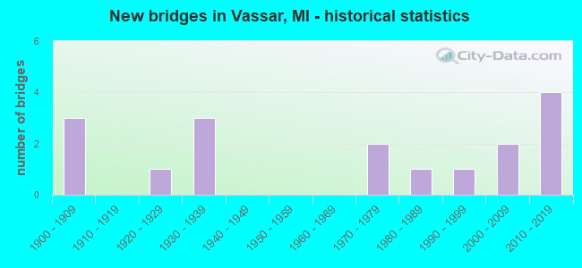
- New bridges - historical statistics
- 31900-1909
- 11920-1929
- 31930-1939
- 21970-1979
- 11980-1989
- 11990-1999
- 22000-2009
- 42010-2019

- Reconstructed bridges - Historical Statistics
- 11970-1979
- 11980-1989


- Bridge Condition - Deck
- 22.2%Very good
- 33.3%Good
- 33.3%Satisfactory
- 11.1%Fair

- Bridge Condition - Superstructure
- 22.2%Very good
- 11.1%Good
- 44.4%Satisfactory
- 22.2%Fair

- Bridge Condition - Substructure
- 11.1%Very good
- 55.6%Good
- 22.2%Satisfactory
- 11.1%Fair

- Bridge Condition - Channel
- 9.1%Very good
- 18.2%Good
- 36.4%Satisfactory
- 27.3%Fair
- 9.1%Poor

- Bridge Condition - Culverts
- 50.0%Very good
- 25.0%Good
- 25.0%Satisfactory
Find on map >> Show street view
Structure Number: 1041, Location: 0.5 MI E OF NEW TROY (Lat: 41.876717, Lng: -86.532792), Route carried "on" structure: County highway , Year Built: 1990, Status: Open, Structure Length: 1.34m (4.40ft), Average Daily Traffic: 651 (year 2007), Truck Traffic: 4%, Average Future Daily Traffic: 750 (year 2027), Design Load: HS 20, Features Intersected: EAST BRANCH GALIEN RIVER, Facility Carried by Structure: PARDEE ROAD
Minimum Vertical Clearance: 30.48m (100.00ft), Kilometerpoint: 8.723, Lanes on structure: 2, Owner: County Highway Agency, Approaching Roadway Width: 8.5m (27.9ft), Skew: 1 degrees, Material/Design: Prestressed concrete, Design/Construction: Box Beam or Girders - Multiple, Number Of Spans In Main Unit: 1, Length of Maximum Span: 12.8m (42.0ft), Curb-To-Curb Width: 10.7m (35.1ft), Out-to-Out Width: 11.5m (37.7ft)
Condition: Deck: Good, Superstructure: Satisfactory, Substructure: Very good, Channel: Fair, Operating Rating: 67.1 metric tons, Method Used To Determine Operating Rating: Load Factor (LF) rating reported by rating factor (RF) method using MS18 loading, Inventory Rating: 40.2 metric tons, Method Used To Determine Inventory Rating: Load Factor (LF) rating reported by rating factor (RF) method using MS18 loading, Structural Evaluation: Equal to present minimum criteria, Deck Geometry: Equal to present minimum criteria, Waterway Adequacy: Equal to present minimum criteria, Approach Roadway Alignment: Equal to present desirable criteria, Designated Inspection Frequency: Every 24 months, Inspection Date: July 2020, Deck Structure Type: Concrete Cast-file-Place, Wearing Surface/Protective System: Wearing Surface: Monolithic Concrete, Deck Protection: Epoxy Coated Reinforcing
Find on map >> Show street view
Structure Number: 1065, Location: 2.7 MI NE OF BRONSON (Lat: 41.891744, Lng: -85.151967), Route carried "on" structure: US 12, Year Built: 2016, Status: Open, Structure Length: 1.65m (5.41ft), Average Daily Traffic: 5,850 (year 2016), Truck Traffic: 7%, Average Future Daily Traffic: 6,475 (year 2036), Design Load: Greater than HL93, Features Intersected: SWAN CREEK
Minimum Vertical Clearance: 30.48m (100.00ft), Kilometerpoint: 14.079, Lanes on structure: 2, Base Highway Network: Yes (Inventory Route: 92, Subroute: 7), Owner: State Highway Agency, Approaching Roadway Width: 13.4m (44.0ft), Skew: 1 degrees, Material/Design: Prestressed concrete, Design/Construction: Box Beam or Girders - Single/Spread, Number Of Spans In Main Unit: 1, Length of Maximum Span: 15.6m (51.2ft), Curb-To-Curb Width: 13.4m (44.0ft), Out-to-Out Width: 14.4m (47.2ft)
Condition: Deck: Very good, Superstructure: Very good, Substructure: Good, Channel: Fair, Operating Rating: 71.6 metric tons, Method Used To Determine Operating Rating: Load and Resistance Factor Rating (LRFR) rating reported by rating factor(RF) method using HL-93 loadings, Inventory Rating: 43.4 metric tons, Method Used To Determine Inventory Rating: Load and Resistance Factor Rating (LRFR) rating reported by rating factor(RF) method using HL-93 loadings, Structural Evaluation: Better than present minimum criteria, Deck Geometry: Equal to present minimum criteria, Waterway Adequacy: Equal to present desirable criteria, Approach Roadway Alignment: Better than present minimum criteria, Designated Inspection Frequency: Every 24 months, Inspection Date: May 2021, Deck Structure Type: Concrete Cast-file-Place, Wearing Surface/Protective System: Wearing Surface: Epoxy Overlay, Deck Protection: Epoxy Coated Reinforcing
Find on map >> Show street view
Structure Number: 10408, Location: 9.5 MI NW OF GENESEE COL (Lat: 43.350383, Lng: -83.579208), Route carried "on" structure: State highway 15, Year Built: 2000, Status: Open, Structure Length: 1.50m (4.92ft), Average Daily Traffic: 4,811 (year 2007), Truck Traffic: 6%, Average Future Daily Traffic: 9,697 (year 2018), Design Load: HS 25 or greater, Features Intersected: GOODINGS CREEK
Minimum Vertical Clearance: 30.48m (100.00ft), Kilometerpoint: 15.280, Lanes on structure: 2, Base Highway Network: Yes (Inventory Route: 27, Subroute: 3), Owner: State Highway Agency, Approaching Roadway Width: 13.1m (43.0ft), Material/Design: Prestressed concrete, Design/Construction: Box Beam or Girders - Single/Spread, Number Of Spans In Main Unit: 1, Length of Maximum Span: 14.8m (48.6ft), Curb-To-Curb Width: 13.1m (43.0ft), Out-to-Out Width: 13.8m (45.3ft)
Condition: Deck: Fair, Superstructure: Very good, Substructure: Good, Channel: Good, Operating Rating: 78.1 metric tons, Method Used To Determine Operating Rating: Load Factor (LF) rating reported by rating factor (RF) method using MS18 loading, Inventory Rating: 39.9 metric tons, Method Used To Determine Inventory Rating: Load Factor (LF) rating reported by rating factor (RF) method using MS18 loading, Structural Evaluation: Better than present minimum criteria, Deck Geometry: Equal to present minimum criteria, Waterway Adequacy: Equal to present desirable criteria, Approach Roadway Alignment: Equal to present desirable criteria, Designated Inspection Frequency: Every 24 months, Inspection Date: August 2020, Deck Structure Type: Concrete Cast-file-Place, Wearing Surface/Protective System: Wearing Surface: Monolithic Concrete, Deck Protection: Epoxy Coated Reinforcing
Find on map >> Show street view
Structure Number: 1041, Location: IN VASSAR (Lat: 43.370903, Lng: -83.580764), Route carried "on" structure: State highway 15, Year Built: 2015, Status: Open, Structure Length: 9.46m (31.04ft), Average Daily Traffic: 14,550 (year 2013), Truck Traffic: 2%, Average Future Daily Traffic: 16,900 (year 2033), Design Load: Greater than HL93, Features Intersected: CASS RIVER
Minimum Vertical Clearance: 30.48m (100.00ft), Kilometerpoint: 17.644, Lanes on structure: 3, Base Highway Network: Yes (Inventory Route: 27, Subroute: 3), Owner: State Highway Agency, Approaching Roadway Width: 12.5m (41.0ft), Material/Design: Steel continuous, Design/Construction: Stringer/Multi-beam, Number Of Spans In Main Unit: 3, Number Of Approach Spans: 2, Length of Maximum Span: 24.7m (81.0ft), Curb or Sidewalk Widths: Left: 1.6m (5.2ft), Right: 1.6m (5.2ft), Curb-To-Curb Width: 12.2m (40.0ft), Out-to-Out Width: 16.2m (53.1ft)
Condition: Deck: Very good, Superstructure: Good, Substructure: Good, Channel: Satisfactory, Operating Rating: 45.7 metric tons, Method Used To Determine Operating Rating: Load and Resistance Factor Rating (LRFR) rating reported by rating factor(RF) method using HL-93 loadings, Inventory Rating: 35.3 metric tons, Method Used To Determine Inventory Rating: Load and Resistance Factor Rating (LRFR) rating reported by rating factor(RF) method using HL-93 loadings, Structural Evaluation: Better than present minimum criteria, Deck Geometry: Meets minimum limits, Waterway Adequacy: Equal to present desirable criteria, Approach Roadway Alignment: Equal to present desirable criteria, Designated Inspection Frequency: Every 24 months, Underwater Inspection Frequency: Every 60 months, Inspection Date: November 2021, Underwater Inspection Date: July 2020, Deck Structure Type: Concrete Cast-file-Place, Wearing Surface/Protective System: Wearing Surface: Monolithic Concrete, Deck Protection: Epoxy Coated Reinforcing
Find on map >> Show street view
Structure Number: 10457, Location: SEC 26-35 TUSCOLA TWP (Lat: 43.321761, Lng: -83.614233), Route carried "on" structure: County highway 7924, Year Built: 2017, Status: Open, Structure Length: 0.69m (2.26ft), Average Daily Traffic: 2,230 (year 2009), Average Future Daily Traffic: 4,030 (year 2029), Design Load: H 15, Features Intersected: MILLINGTON CREEK, Facility Carried by Structure: ORMES ROAD
Minimum Vertical Clearance: 30.48m (100.00ft), Kilometerpoint: 6.616, Lanes on structure: 2, Owner: County Highway Agency, Approaching Roadway Width: 8.5m (27.9ft), Skew: 1 degrees, Material/Design: Concrete, Design/Construction: Culvert, Number Of Spans In Main Unit: 1, Length of Maximum Span: 6.2m (20.3ft), Curb-To-Curb Width: 12.2m (40.0ft), Out-to-Out Width: 14.6m (47.9ft)
Condition: Channel: Good, Culverts: Very good, Operating Rating: 64.8 metric tons, Method Used To Determine Operating Rating: Load and Resistance Factor Rating (LRFR) rating reported by rating factor(RF) method using HL-93 loadings, Inventory Rating: 49.9 metric tons, Method Used To Determine Inventory Rating: Load and Resistance Factor Rating (LRFR) rating reported by rating factor(RF) method using HL-93 loadings, Structural Evaluation: Equal to present desirable criteria, Deck Geometry: Equal to present minimum criteria, Waterway Adequacy: Better than present minimum criteria, Approach Roadway Alignment: Equal to present desirable criteria, Length Of Structure Improvement: 0.65m (2.13ft), Designated Inspection Frequency: Every 24 months, Inspection Date: July 2021, Bridge Improvement Cost: $180,000, Roadway Improvement Cost: $20,000, Total Project Cost: $225,000, Deck Structure Type: Concrete Cast-file-Place, Wearing Surface/Protective System: Wearing Surface: Bituminous
Find on map >> Show street view
Structure Number: 10498, Location: SEC 31 VASSAR TWP (Lat: 43.311036, Lng: -83.583433), Route carried "on" structure: County highway 7919, Year Built: 1930, Status: Open, Structure Length: 0.82m (2.69ft), Average Daily Traffic: 1,565 (year 2009), Average Future Daily Traffic: 2,825 (year 2029), Design Load: H 15, Features Intersected: MILLINGTON CREEK, Facility Carried by Structure: VASSAR ROAD
Minimum Vertical Clearance: 30.48m (100.00ft), Kilometerpoint: 9.806, Lanes on structure: 2, Owner: County Highway Agency, Approaching Roadway Width: 9.1m (29.9ft), Material/Design: Steel, Design/Construction: Stringer/Multi-beam, Number Of Spans In Main Unit: 1, Length of Maximum Span: 7.6m (24.9ft), Curb-To-Curb Width: 9.1m (29.9ft), Out-to-Out Width: 10.2m (33.5ft)
Condition: Deck: Satisfactory, Superstructure: Fair, Substructure: Fair, Channel: Satisfactory, Operating Rating: 50.5 metric tons, Method Used To Determine Operating Rating: Load Factor (LF) rating reported by rating factor (RF) method using MS18 loading, Inventory Rating: 30.1 metric tons, Method Used To Determine Inventory Rating: Load Factor (LF) rating reported by rating factor (RF) method using MS18 loading, Structural Evaluation: Somewhat better than minimum adequacy, Deck Geometry: Somewhat better than minimum adequacy, Waterway Adequacy: Somewhat better than minimum adequacy, Approach Roadway Alignment: Equal to present desirable criteria, Length Of Structure Improvement: 1.00m (3.28ft), Designated Inspection Frequency: Every 24 months, Inspection Date: July 2021, Bridge Improvement Cost: $237,000, Roadway Improvement Cost: $20,000, Total Project Cost: $175,000, Deck Structure Type: Concrete Cast-file-Place, Wearing Surface/Protective System: Wearing Surface: Bituminous
Find on map >> Show street view
Structure Number: 10645, Location: SEC 27 TUSCOLA TWP (Lat: 43.332372, Lng: -83.641789), Route carried "on" structure: ServiceCounty highway , Year Built: 1979, Status: Open, Structure Length: 0.72m (2.36ft), Average Daily Traffic: 190 (year 2009), Average Future Daily Traffic: 340 (year 2029), Design Load: H 20, Features Intersected: MILLINGTON CREEK, Facility Carried by Structure: LOREN ROAD
Minimum Vertical Clearance: 30.48m (100.00ft), Kilometerpoint: 1.704, Lanes on structure: 2, Owner: County Highway Agency, Approaching Roadway Width: 9.1m (29.9ft), Skew: 3 degrees, Material/Design: Steel, Design/Construction: Culvert, Number Of Spans In Main Unit: 1, Length of Maximum Span: 7.2m (23.6ft)
Condition: Channel: Satisfactory, Culverts: Satisfactory, Operating Rating: 33.0 metric tons, Method Used To Determine Operating Rating: Load Factor (LF) rating reported by rating factor (RF) method using MS18 loading, Inventory Rating: 26.2 metric tons, Method Used To Determine Inventory Rating: Load Factor (LF) rating reported by rating factor (RF) method using MS18 loading, Structural Evaluation: Equal to present minimum criteria, Waterway Adequacy: Equal to present desirable criteria, Approach Roadway Alignment: Somewhat better than minimum adequacy, Designated Inspection Frequency: Every 24 months, Inspection Date: June 2021
Find on map >> Show street view
Structure Number: 10646, Location: SEC 26-27 TUSCOLA TWP (Lat: 43.327808, Lng: -83.623822), Route carried "on" structure: ServiceCounty highway , Year Built: 1930, Year Reconstructed: 1977, Status: Open, Structure Length: 0.73m (2.40ft), Average Daily Traffic: 330 (year 2009), Average Future Daily Traffic: 600 (year 2029), Design Load: H 20, Features Intersected: MILLINGTON CREEK, Facility Carried by Structure: BUELL ROAD
Minimum Vertical Clearance: 30.48m (100.00ft), Kilometerpoint: 8.461, Lanes on structure: 2, Owner: County Highway Agency, Approaching Roadway Width: 8.5m (27.9ft), Material/Design: Steel, Design/Construction: Stringer/Multi-beam, Number Of Spans In Main Unit: 1, Length of Maximum Span: 6.6m (21.7ft), Curb-To-Curb Width: 8.9m (29.2ft), Out-to-Out Width: 9.0m (29.5ft)
Condition: Deck: Satisfactory, Superstructure: Fair, Substructure: Satisfactory, Channel: Poor, Operating Rating: 59.9 metric tons, Method Used To Determine Operating Rating: Load Factor (LF) rating reported by rating factor (RF) method using MS18 loading, Inventory Rating: 36.0 metric tons, Method Used To Determine Inventory Rating: Load Factor (LF) rating reported by rating factor (RF) method using MS18 loading, Structural Evaluation: Somewhat better than minimum adequacy, Deck Geometry: Equal to present minimum criteria, Waterway Adequacy: Better than present minimum criteria, Approach Roadway Alignment: Equal to present desirable criteria, Designated Inspection Frequency: Every 24 months, Inspection Date: June 2021, Deck Structure Type: Corrugated Steel, Wearing Surface/Protective System: Wearing Surface: Bituminous
Find on map >> Show street view
Structure Number: 10647, Location: SEC 11-12 TUSCOLA TWP (Lat: 43.368369, Lng: -83.604672), Route carried "on" structure: County highway , Year Built: 2001, Status: Open, Structure Length: 3.96m (12.99ft), Average Daily Traffic: 965 (year 2009), Average Future Daily Traffic: 1,740 (year 2029), Design Load: HS 20+Mod, Features Intersected: SAGINAW VALLEY RR, Facility Carried by Structure: COTTRELL ROAD
Minimum Vertical Clearance: 30.48m (100.00ft), Kilometerpoint: 1.424, Lanes on structure: 2, Owner: County Highway Agency, Approaching Roadway Width: 8.5m (27.9ft), Material/Design: Prestressed concrete, Design/Construction: Box Beam or Girders - Multiple, Number Of Spans In Main Unit: 1, Number Of Approach Spans: 2, Length of Maximum Span: 17.4m (57.1ft), Curb-To-Curb Width: 8.7m (28.5ft), Out-to-Out Width: 9.5m (31.2ft)
Condition: Deck: Satisfactory, Superstructure: Satisfactory, Substructure: Good, Operating Rating: 58.3 metric tons, Method Used To Determine Operating Rating: Load Factor (LF) rating reported by rating factor (RF) method using MS18 loading, Inventory Rating: 35.0 metric tons, Method Used To Determine Inventory Rating: Load Factor (LF) rating reported by rating factor (RF) method using MS18 loading, Structural Evaluation: Equal to present minimum criteria, Deck Geometry: Somewhat better than minimum adequacy, Approach Roadway Alignment: Meets minimum limits, Designated Inspection Frequency: Every 24 months, Inspection Date: June 2021, Deck Structure Type: Concrete Precast Panels, Wearing Surface/Protective System: Wearing Surface: Bituminous, Membrane: Preformed Fabric, Deck Protection: Epoxy Coated Reinforcing
Find on map >> Show street view
Structure Number: 1065, Location: SEC 22-27 VASSAR TWP (Lat: 43.337339, Lng: -83.517078), Route carried "on" structure: ServiceCounty highway , Year Built: 1979, Status: Open, Structure Length: 0.84m (2.76ft), Average Daily Traffic: 335 (year 2009), Average Future Daily Traffic: 605 (year 2029), Design Load: H 20, Features Intersected: GOODING CREEK, Facility Carried by Structure: HANES ROAD
Minimum Vertical Clearance: 30.48m (100.00ft), Kilometerpoint: 5.396, Lanes on structure: 2, Owner: County Highway Agency, Approaching Roadway Width: 9.1m (29.9ft), Skew: 1 degrees, Material/Design: Steel, Design/Construction: Culvert, Number Of Spans In Main Unit: 2, Length of Maximum Span: 3.7m (12.1ft), Curb-To-Curb Width: 7.3m (24.0ft), Out-to-Out Width: 19.8m (65.0ft)
Condition: Channel: Fair, Culverts: Good, Operating Rating: 97.2 metric tons, Method Used To Determine Operating Rating: Load Factor (LF) rating reported by rating factor (RF) method using MS18 loading, Inventory Rating: 97.2 metric tons, Method Used To Determine Inventory Rating: Load Factor (LF) rating reported by rating factor (RF) method using MS18 loading, Structural Evaluation: Better than present minimum criteria, Deck Geometry: Somewhat better than minimum adequacy, Waterway Adequacy: Equal to present minimum criteria, Approach Roadway Alignment: Equal to present desirable criteria, Designated Inspection Frequency: Every 24 months, Inspection Date: July 2021
Find on map >> Show street view
Structure Number: 10653, Location: SEC 21-22 VASSAR TWP (Lat: 43.339894, Lng: -83.521453), Route carried "on" structure: ServiceCounty highway , Year Built: 2017, Status: Open, Structure Length: 1.40m (4.59ft), Average Daily Traffic: 905 (year 2016), Truck Traffic: 5%, Average Future Daily Traffic: 1,346 (year 2036), Design Load: Greater than HL93, Features Intersected: GOODING CREEK, Facility Carried by Structure: CAINE ROAD
Minimum Vertical Clearance: 30.48m (100.00ft), Kilometerpoint: 6.507, Lanes on structure: 2, Owner: County Highway Agency, Approaching Roadway Width: 8.5m (27.9ft), Skew: 9 degrees, Material/Design: Concrete, Design/Construction: Culvert, Number Of Spans In Main Unit: 1, Length of Maximum Span: 13.4m (44.0ft), Curb-To-Curb Width: 8.5m (27.9ft), Out-to-Out Width: 16.3m (53.5ft)
Condition: Channel: Very good, Culverts: Very good, Operating Rating: 71.3 metric tons, Method Used To Determine Operating Rating: Load and Resistance Factor Rating (LRFR) rating reported by rating factor(RF) method using HL-93 loadings, Inventory Rating: 54.8 metric tons, Method Used To Determine Inventory Rating: Load and Resistance Factor Rating (LRFR) rating reported by rating factor(RF) method using HL-93 loadings, Structural Evaluation: Equal to present desirable criteria, Deck Geometry: Somewhat better than minimum adequacy, Waterway Adequacy: Equal to present desirable criteria, Approach Roadway Alignment: Equal to present minimum criteria, Designated Inspection Frequency: Every 24 months, Inspection Date: July 2021, Wearing Surface/Protective System: Wearing Surface: Bituminous
Find on map >> Show street view
Structure Number: 10654, Location: SEC 3-4 VASSAR TWP (Lat: 43.392056, Lng: -83.522403), Route carried "on" structure: ServiceCounty highway , Year Built: 1982, Status: Open, Structure Length: 6.40m (21.00ft), Average Daily Traffic: 1,600 (year 2014), Truck Traffic: 1%, Average Future Daily Traffic: 2,155 (year 2034), Design Load: HS 20, Features Intersected: CASS RIVER, Facility Carried by Structure: CAINE ROAD
Minimum Vertical Clearance: 30.48m (100.00ft), Kilometerpoint: 12.344, Lanes on structure: 2, Owner: County Highway Agency, Approaching Roadway Width: 9.7m (31.8ft), Skew: 1 degrees, Material/Design: Prestressed concrete, Design/Construction: Box Beam or Girders - Multiple, Number Of Spans In Main Unit: 3, Length of Maximum Span: 21.3m (69.9ft), Curb-To-Curb Width: 9.5m (31.2ft), Out-to-Out Width: 10.5m (34.4ft)
Condition: Deck: Good, Superstructure: Satisfactory, Substructure: Good, Channel: Satisfactory, Operating Rating: 63.2 metric tons, Method Used To Determine Operating Rating: Load Factor (LF) rating reported by rating factor (RF) method using MS18 loading, Inventory Rating: 37.9 metric tons, Method Used To Determine Inventory Rating: Load Factor (LF) rating reported by rating factor (RF) method using MS18 loading, Structural Evaluation: Equal to present minimum criteria, Deck Geometry: Somewhat better than minimum adequacy, Waterway Adequacy: Equal to present desirable criteria, Approach Roadway Alignment: Equal to present desirable criteria, Length Of Structure Improvement: 6.40m (21.00ft), Designated Inspection Frequency: Every 24 months, Inspection Date: April 2020, Bridge Improvement Cost: $92,000, Roadway Improvement Cost: $14,000, Total Project Cost: $124,000 ( Estimate for 2015), Deck Structure Type: Concrete Precast Panels, Wearing Surface/Protective System: Wearing Surface: Bituminous, Membrane: Preformed Fabric, Deck Protection: Epoxy Coated Reinforcing
Find on map >> Show street view
Structure Number: 10678, Location: CITY OF VASSAR (Lat: 43.378981, Lng: -83.584225), Route carried "on" structure: Business City street 7921, Year Built: 1934, Year Reconstructed: 1989, Status: Open, Structure Length: 3.04m (9.97ft), Average Daily Traffic: 250 (year 1989), Truck Traffic: 10%, Average Future Daily Traffic: 500 (year 2015), Design Load: HS 20+Mod, Features Intersected: HURON & EASTERN RR, Facility Carried by Structure: DIVISION STREET
Minimum Vertical Clearance: 30.48m (100.00ft), Kilometerpoint: 0.764, Lanes on structure: 2, Owner: City or Municipal Highway Agency, Approaching Roadway Width: 11.5m (37.7ft), Skew: 3 degrees, Material/Design: Steel, Design/Construction: Stringer/Multi-beam, Number Of Spans In Main Unit: 3, Length of Maximum Span: 10.9m (35.8ft), Curb-To-Curb Width: 10.9m (35.8ft), Out-to-Out Width: 11.7m (38.4ft)
Condition: Deck: Good, Superstructure: Satisfactory, Substructure: Satisfactory, Operating Rating: 97.2 metric tons, Method Used To Determine Operating Rating: Load Factor (LF) rating reported by rating factor (RF) method using MS18 loading, Inventory Rating: 67.1 metric tons, Method Used To Determine Inventory Rating: Load Factor (LF) rating reported by rating factor (RF) method using MS18 loading, Structural Evaluation: Equal to present minimum criteria, Deck Geometry: Better than present minimum criteria, Approach Roadway Alignment: Equal to present desirable criteria, Designated Inspection Frequency: Every 24 months, Inspection Date: November 2021, Deck Structure Type: Concrete Cast-file-Place, Wearing Surface/Protective System: Wearing Surface: Monolithic Concrete, Deck Protection: Epoxy Coated Reinforcing
Find on map >> Show street view
Structure Number: 10676, Location: CITY OF VASSAR (Lat: 43.366164, Lng: -83.588753), Route carried "under" structure: City street 7930, Year Built: 1903, Structure Length: 0. m, Average Daily Traffic: 2,000 (year 0000), Features Intersected: MAIN STREET, Facility Carried by Structure: SAGINAW VALLEY RWY
Minimum Vertical Clearance: 4.36m (14.30ft), Kilometerpoint: 11.329, Lanes under structure: 2, Material/Design: Steel, Design/Construction: Stringer/Multi-beam, Length of Maximum Span: 15.5m (50.9ft)
Find on map >> Show street view
Structure Number: 10677, Location: CITY OF VASSAR (Lat: 43.374172, Lng: -83.577564), Route carried "under" structure: City street , Year Built: 1902, Structure Length: 0. m, Average Daily Traffic: 850 (year 0000), Features Intersected: CASS STREET, Facility Carried by Structure: HURON&EASTERN RR
Minimum Vertical Clearance: 3.73m (12.24ft), Kilometerpoint: 0.626, Lanes under structure: 2, Material/Design: Steel, Design/Construction: Stringer/Multi-beam, Length of Maximum Span: 14.3m (46.9ft)
Find on map >> Show street view
Structure Number: 10679, Location: CITY OF VASSAR (Lat: 43.376481, Lng: -83.577614), Route carried "under" structure: City street , Year Built: 1905, Structure Length: 0. m, Average Daily Traffic: 90 (year 2007), Features Intersected: GRANT STREET (EAST), Facility Carried by Structure: HURON & EASTERN RR
Minimum Vertical Clearance: 3.96m (12.99ft), Kilometerpoint: 0.272, Lanes under structure: 2, Material/Design: Steel, Design/Construction: Stringer/Multi-beam, Length of Maximum Span: 6.7m (22.0ft)
Find on map >> Show street view
Structure Number: 1068, Location: CITY OF VASSAR (Lat: 43.376447, Lng: -83.579625), Route carried "under" structure: City street , Year Built: 1922, Structure Length: 0. m, Average Daily Traffic: 90 (year 0000), Features Intersected: GRANT STREET (WEST), Facility Carried by Structure: HURON & EASTERN RR
Minimum Vertical Clearance: 3.73m (12.24ft), Kilometerpoint: 0.108, Lanes under structure: 2, Material/Design: Steel, Design/Construction: Stringer/Multi-beam, Length of Maximum Span: 8.5m (27.9ft)