Bridge Statistics for Vandercook Lake, Michigan (MI)
Condition, Traffic, Stress, Structural Evaluation, Project Costs
- National Bridge Inventory (NBI) Statistics
- 13Number of bridges
- 102ft / 31.3mTotal length
- 103,323Total average daily traffic
- 8,797Total average daily truck traffic
- National Bridge Inventory (NBI) Registered Bridges for Vandercook Lake
- No street view available for this location
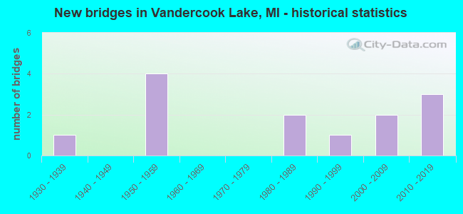
- New bridges - historical statistics
- 11930-1939
- 41950-1959
- 21980-1989
- 11990-1999
- 22000-2009
- 32010-2019


- Bridge Condition - Deck
- 50.0%Good
- 25.0%Satisfactory
- 12.5%Poor
- 12.5%Serious

- Bridge Condition - Superstructure
- 12.5%Very good
- 25.0%Good
- 37.5%Satisfactory
- 25.0%Fair

- Bridge Condition - Substructure
- 12.5%Very good
- 37.5%Good
- 12.5%Satisfactory
- 37.5%Fair

- Bridge Condition - Channel
- 57.1%Good
- 28.6%Satisfactory
- 14.3%Poor
Find on map >> Show street view
Structure Number: 4399, Location: 3.0 MI SE OF JACKSON (Lat: 42.213672, Lng: -84.374369), Route carried "on" structure: State highway 50, Year Built: 2005, Status: Open, Structure Length: 1.58m (5.18ft), Average Daily Traffic: 7,114 (year 2007), Truck Traffic: 5%, Average Future Daily Traffic: 9,926 (year 2018), Design Load: HS 25 or greater, Features Intersected: GRAND RIVER
Minimum Vertical Clearance: 30.48m (100.00ft), Kilometerpoint: 1.825, Lanes on structure: 2, Base Highway Network: Yes (Inventory Route: 338, Subroute: 14), Owner: State Highway Agency, Approaching Roadway Width: 12.2m (40.0ft), Material/Design: Prestressed concrete, Design/Construction: Box Beam or Girders - Single/Spread, Number Of Spans In Main Unit: 1, Length of Maximum Span: 14.8m (48.6ft), Curb or Sidewalk Widths: Left: 0.4m (1.3ft), Right: 0.4m (1.3ft), Curb-To-Curb Width: 13.4m (44.0ft), Out-to-Out Width: 14.2m (46.6ft)
Condition: Deck: Good, Superstructure: Good, Substructure: Good, Channel: Good, Operating Rating: 72.5 metric tons, Method Used To Determine Operating Rating: Load Factor (LF), Inventory Rating: 43.4 metric tons, Method Used To Determine Inventory Rating: Load Factor (LF), Structural Evaluation: Better than present minimum criteria, Deck Geometry: Equal to present minimum criteria, Waterway Adequacy: Equal to present desirable criteria, Approach Roadway Alignment: Equal to present desirable criteria, Designated Inspection Frequency: Every 24 months, Inspection Date: August 2020, Deck Structure Type: Concrete Cast-file-Place, Wearing Surface/Protective System: Wearing Surface: Monolithic Concrete, Deck Protection: Epoxy Coated Reinforcing
Find on map >> Show street view
Structure Number: 4442, Location: @ N JCT M-50 (Lat: 42.205089, Lng: -84.369497), Route carried "on" structure: US 127, Year Built: 1959, Status: Open, Structure Length: 8.90m (29.20ft), Average Daily Traffic: 10,893 (year 2007), Truck Traffic: 10%, Average Future Daily Traffic: 15,811 (year 2018), Design Load: HS 20, Features Intersected: MDOT RR COR & M-50
Minimum Vertical Clearance: 30.48m (100.00ft), Kilometerpoint: 1.543, Lanes on structure: 2, Lanes under structure: 2, Base Highway Network: Yes (Inventory Route: 89, Subroute: 9), Owner: State Highway Agency, Approaching Roadway Width: 12.8m (42.0ft), Skew: 14 degrees, Material/Design: Steel, Design/Construction: Stringer/Multi-beam, Number Of Spans In Main Unit: 4, Length of Maximum Span: 22.5m (73.8ft), Curb-To-Curb Width: 10.5m (34.4ft), Out-to-Out Width: 11.1m (36.4ft)
Condition: Deck: Serious, Superstructure: Fair, Substructure: Fair, Operating Rating: 78.4 metric tons, Method Used To Determine Operating Rating: Load Factor (LF) rating reported by rating factor (RF) method using MS18 loading, Inventory Rating: 47.0 metric tons, Method Used To Determine Inventory Rating: Load Factor (LF) rating reported by rating factor (RF) method using MS18 loading, Structural Evaluation: Somewhat better than minimum adequacy, Deck Geometry: Somewhat better than minimum adequacy, Underclear: Somewhat better than minimum adequacy, Approach Roadway Alignment: Better than present minimum criteria, Designated Inspection Frequency: Every 12 months, Inspection Date: June 2021, Deck Structure Type: Concrete Cast-file-Place, Wearing Surface/Protective System: Wearing Surface: Epoxy Overlay
Find on map >> Show street view
Structure Number: 4443, Location: @ N JCT M-50 (Lat: 42.205311, Lng: -84.369603), Route carried "on" structure: US 127, Year Built: 1959, Status: Open, Structure Length: 8.44m (27.69ft), Average Daily Traffic: 11,135 (year 2007), Truck Traffic: 13%, Average Future Daily Traffic: 9,416 (year 2018), Design Load: HS 20, Features Intersected: MDOT RR COR & M-50
Minimum Vertical Clearance: 30.48m (100.00ft), Kilometerpoint: 1.571, Lanes on structure: 2, Lanes under structure: 2, Base Highway Network: Yes (Inventory Route: 89, Subroute: 10), Owner: State Highway Agency, Approaching Roadway Width: 12.8m (42.0ft), Skew: 14 degrees, Material/Design: Steel, Design/Construction: Stringer/Multi-beam, Number Of Spans In Main Unit: 4, Length of Maximum Span: 21.3m (69.9ft), Curb-To-Curb Width: 10.5m (34.4ft), Out-to-Out Width: 11.1m (36.4ft)
Condition: Deck: Poor, Superstructure: Fair, Substructure: Fair, Operating Rating: 82.3 metric tons, Method Used To Determine Operating Rating: Load Factor (LF) rating reported by rating factor (RF) method using MS18 loading, Inventory Rating: 49.2 metric tons, Method Used To Determine Inventory Rating: Load Factor (LF) rating reported by rating factor (RF) method using MS18 loading, Structural Evaluation: Somewhat better than minimum adequacy, Deck Geometry: Somewhat better than minimum adequacy, Underclear: Somewhat better than minimum adequacy, Approach Roadway Alignment: Better than present minimum criteria, Designated Inspection Frequency: Every 12 months, Inspection Date: June 2021, Deck Structure Type: Concrete Cast-file-Place, Wearing Surface/Protective System: Wearing Surface: Epoxy Overlay
Find on map >> Show street view
Structure Number: 4446, Location: @ S JCT M-50 (Lat: 42.196928, Lng: -84.369550), Route carried "on" structure: State highway 50, Year Built: 2012, Status: Open, Structure Length: 6.29m (20.64ft), Average Daily Traffic: 9,715 (year 2011), Truck Traffic: 6%, Average Future Daily Traffic: 11,430 (year 2031), Design Load: HL 93, Features Intersected: US-127
Minimum Vertical Clearance: 30.48m (100.00ft), Kilometerpoint: 2.818, Lanes on structure: 3, Lanes under structure: 5, Base Highway Network: Yes (Inventory Route: 89, Subroute: 10), Owner: State Highway Agency, Approaching Roadway Width: 15.8m (51.8ft), Material/Design: Prestressed concrete, Design/Construction: Box Beam or Girders - Multiple, Number Of Spans In Main Unit: 2, Length of Maximum Span: 32.0m (105.0ft), Curb-To-Curb Width: 17.1m (56.1ft), Out-to-Out Width: 22.7m (74.5ft)
Condition: Deck: Good, Superstructure: Satisfactory, Substructure: Good, Operating Rating: 48.3 metric tons, Method Used To Determine Operating Rating: Load and Resistance Factor Rating (LRFR) rating reported by rating factor(RF) method using HL-93 loadings, Inventory Rating: 32.1 metric tons, Method Used To Determine Inventory Rating: Load and Resistance Factor Rating (LRFR) rating reported by rating factor(RF) method using HL-93 loadings, Structural Evaluation: Equal to present minimum criteria, Deck Geometry: Superior to present desirable criteria, Underclear: Somewhat better than minimum adequacy, Approach Roadway Alignment: Equal to present desirable criteria, Designated Inspection Frequency: Every 24 months, Inspection Date: June 2021, Deck Structure Type: Concrete Cast-file-Place, Wearing Surface/Protective System: Wearing Surface: Epoxy Overlay, Deck Protection: Epoxy Coated Reinforcing
Find on map >> Show street view
Structure Number: 4471, Location: 1 MI W OF VANDERCOOK LAKE (Lat: 42.201406, Lng: -84.417700), Route carried "on" structure: County highway 2009, Year Built: 1937, Year Reconstructed: 1980, Status: Open, Structure Length: 0.76m (2.49ft), Average Daily Traffic: 4,916 (year 2005), Average Future Daily Traffic: 5,500 (year 2019), Design Load: HS 20+Mod, Features Intersected: GRAND RIVER, Facility Carried by Structure: BADGLEY ROAD
Minimum Vertical Clearance: 30.48m (100.00ft), Kilometerpoint: 1.593, Lanes on structure: 2, Owner: County Highway Agency, Approaching Roadway Width: 8.8m (28.9ft), Material/Design: Prestressed concrete, Design/Construction: Box Beam or Girders - Multiple, Number Of Spans In Main Unit: 1, Length of Maximum Span: 7.0m (23.0ft), Curb-To-Curb Width: 10.1m (33.1ft), Out-to-Out Width: 10.1m (33.1ft)
Condition: Deck: Satisfactory, Superstructure: Satisfactory, Substructure: Fair, Channel: Poor, Operating Rating: 63.1 metric tons, Method Used To Determine Operating Rating: Load Factor (LF), Inventory Rating: 37.8 metric tons, Method Used To Determine Inventory Rating: Load Factor (LF), Structural Evaluation: Somewhat better than minimum adequacy, Deck Geometry: Meets minimum limits, Waterway Adequacy: Equal to present desirable criteria, Approach Roadway Alignment: Meets minimum limits, Designated Inspection Frequency: Every 24 months, Inspection Date: May 2021, Deck Structure Type: Concrete Cast-file-Place, Wearing Surface/Protective System: Wearing Surface: Bituminous, Membrane: Preformed Fabric
Find on map >> Show street view
Structure Number: 4472, Location: JUST W OF VANDERCOOK LAKE (Lat: 42.198372, Lng: -84.405225), Route carried "on" structure: County highway 2009, Year Built: 1989, Status: Open, Structure Length: 0.91m (2.99ft), Average Daily Traffic: 7,800 (year 2005), Average Future Daily Traffic: 9,000 (year 2019), Design Load: HS 20+Mod, Features Intersected: GRAND RIVER, Facility Carried by Structure: HINKLEY ROAD
Minimum Vertical Clearance: 30.48m (100.00ft), Kilometerpoint: 1.027, Lanes on structure: 2, Owner: County Highway Agency, Approaching Roadway Width: 10.4m (34.1ft), Material/Design: Prestressed concrete, Design/Construction: Box Beam or Girders - Multiple, Number Of Spans In Main Unit: 1, Length of Maximum Span: 8.2m (26.9ft), Curb-To-Curb Width: 12.2m (40.0ft), Out-to-Out Width: 13.2m (43.3ft)
Condition: Deck: Good, Superstructure: Good, Substructure: Satisfactory, Channel: Satisfactory, Operating Rating: 76.0 metric tons, Method Used To Determine Operating Rating: Load Factor (LF), Inventory Rating: 45.5 metric tons, Method Used To Determine Inventory Rating: Load Factor (LF), Structural Evaluation: Equal to present minimum criteria, Deck Geometry: Somewhat better than minimum adequacy, Waterway Adequacy: Superior to present desirable criteria, Approach Roadway Alignment: Equal to present desirable criteria, Designated Inspection Frequency: Every 24 months, Inspection Date: May 2021, Deck Structure Type: Concrete Cast-file-Place, Wearing Surface/Protective System: Wearing Surface: Latex Concrete, Deck Protection: Epoxy Coated Reinforcing
Find on map >> Show street view
Structure Number: 4497, Location: .5 MI S OF JACKSON (Lat: 42.203367, Lng: -84.417992), Route carried "on" structure: County highway 2009, Year Built: 1984, Status: Open, Structure Length: 1.22m (4.00ft), Average Daily Traffic: 6,000 (year 2001), Average Future Daily Traffic: 7,300 (year 2017), Design Load: HS 20+Mod, Features Intersected: GRAND RIVER, Facility Carried by Structure: STONEWALL ROAD
Minimum Vertical Clearance: 30.48m (100.00ft), Kilometerpoint: 0.246, Lanes on structure: 2, Owner: County Highway Agency, Approaching Roadway Width: 12.2m (40.0ft), Material/Design: Prestressed concrete, Design/Construction: Box Beam or Girders - Multiple, Number Of Spans In Main Unit: 1, Length of Maximum Span: 12.2m (40.0ft), Curb-To-Curb Width: 12.2m (40.0ft), Out-to-Out Width: 13.2m (43.3ft)
Condition: Deck: Good, Superstructure: Satisfactory, Substructure: Good, Channel: Good, Operating Rating: 64.6 metric tons, Method Used To Determine Operating Rating: Load Factor (LF), Inventory Rating: 38.7 metric tons, Method Used To Determine Inventory Rating: Load Factor (LF), Structural Evaluation: Equal to present minimum criteria, Deck Geometry: Somewhat better than minimum adequacy, Waterway Adequacy: Equal to present minimum criteria, Approach Roadway Alignment: Equal to present desirable criteria, Designated Inspection Frequency: Every 24 months, Inspection Date: May 2021, Deck Structure Type: Concrete Cast-file-Place, Wearing Surface/Protective System: Wearing Surface: Latex Concrete, Deck Protection: Epoxy Coated Reinforcing
Find on map >> Show street view
Structure Number: 4498, Location: 1.3 MI S VANDERCOOK LAKE (Lat: 42.177072, Lng: -84.393556), Route carried "on" structure: County highway 2009, Year Built: 2015, Status: Open, Structure Length: 1.65m (5.41ft), Average Daily Traffic: 5,000 (year 2014), Truck Traffic: 3%, Average Future Daily Traffic: 6,200 (year 2034), Design Load: Greater than HL93, Features Intersected: GRAND RIVER, Facility Carried by Structure: HAGUE RD
Minimum Vertical Clearance: 30.48m (100.00ft), Kilometerpoint: 3.613, Lanes on structure: 2, Owner: County Highway Agency, Approaching Roadway Width: 10.4m (34.1ft), Material/Design: Prestressed concrete, Design/Construction: Box Beam or Girders - Multiple, Number Of Spans In Main Unit: 1, Length of Maximum Span: 16.1m (52.8ft), Curb-To-Curb Width: 10.5m (34.4ft), Out-to-Out Width: 11.5m (37.7ft)
Condition: Deck: Satisfactory, Superstructure: Very good, Substructure: Very good, Channel: Good, Operating Rating: 72.3 metric tons, Method Used To Determine Operating Rating: Load and Resistance Factor Rating (LRFR) rating reported by rating factor(RF) method using HL-93 loadings, Inventory Rating: 55.7 metric tons, Method Used To Determine Inventory Rating: Load and Resistance Factor Rating (LRFR) rating reported by rating factor(RF) method using HL-93 loadings, Structural Evaluation: Equal to present desirable criteria, Deck Geometry: Somewhat better than minimum adequacy, Waterway Adequacy: Better than present minimum criteria, Approach Roadway Alignment: Equal to present desirable criteria, Designated Inspection Frequency: Every 24 months, Inspection Date: August 2021, Deck Structure Type: Concrete Cast-file-Place, Wearing Surface/Protective System: Wearing Surface: Monolithic Concrete, Deck Protection: Epoxy Coated Reinforcing
Find on map >> Show street view
Structure Number: 4499, Location: 1 MI N OF VANDERCOOK LAKE (Lat: 42.209350, Lng: -84.398669), Route carried "on" structure: County highway 2009, Year Built: 1993, Status: Open, Structure Length: 0.85m (2.79ft), Average Daily Traffic: 6,700 (year 2004), Truck Traffic: 8%, Average Future Daily Traffic: 8,000 (year 2022), Design Load: HS 25 or greater, Features Intersected: GRAND RIVER, Facility Carried by Structure: FRANCIS STREET
Minimum Vertical Clearance: 30.48m (100.00ft), Kilometerpoint: 1.437, Lanes on structure: 4, Owner: County Highway Agency, Approaching Roadway Width: 15.9m (52.2ft), Material/Design: Prestressed concrete, Design/Construction: Culvert, Number Of Spans In Main Unit: 1, Length of Maximum Span: 8.5m (27.9ft), Curb or Sidewalk Widths: Left: 0.0m, Right: 1.5m (4.9ft), Curb-To-Curb Width: 15.5m (50.9ft), Out-to-Out Width: 18.2m (59.7ft)
Condition: Channel: Good, Culverts: Good, Operating Rating: 68.2 metric tons, Method Used To Determine Operating Rating: Load Factor (LF), Inventory Rating: 40.8 metric tons, Method Used To Determine Inventory Rating: Load Factor (LF), Structural Evaluation: Better than present minimum criteria, Deck Geometry: Meets minimum limits, Waterway Adequacy: Superior to present desirable criteria, Approach Roadway Alignment: Equal to present desirable criteria, Designated Inspection Frequency: Every 24 months, Inspection Date: May 2021, Deck Structure Type: Concrete Cast-file-Place, Wearing Surface/Protective System: Wearing Surface: Monolithic Concrete, Deck Protection: Epoxy Coated Reinforcing
Find on map >> Show street view
Structure Number: 4529, Location: 2.6 M N 2 M W CEMENT CITY (Lat: 42.114944, Lng: -84.373414), Route carried "on" structure: County highway , Year Built: 2004, Status: Open, Structure Length: 0.73m (2.40ft), Average Daily Traffic: 124 (year 2002), Average Future Daily Traffic: 200 (year 2022), Design Load: HS 20, Features Intersected: GRAND RIVER, Facility Carried by Structure: GATES ROAD
Minimum Vertical Clearance: 30.48m (100.00ft), Kilometerpoint: 4.949, Lanes on structure: 2, Owner: County Highway Agency, Approaching Roadway Width: 7.9m (25.9ft), Skew: 2 degrees, Material/Design: Concrete, Design/Construction: Culvert, Number Of Spans In Main Unit: 1, Length of Maximum Span: 6.1m (20.0ft), Out-to-Out Width: 15.2m (49.9ft)
Condition: Channel: Satisfactory, Culverts: Good, Operating Rating: 54.5 metric tons, Method Used To Determine Operating Rating: Load Factor (LF), Inventory Rating: 32.7 metric tons, Method Used To Determine Inventory Rating: Load Factor (LF), Structural Evaluation: Better than present minimum criteria, Waterway Adequacy: Equal to present desirable criteria, Approach Roadway Alignment: Equal to present minimum criteria, Designated Inspection Frequency: Every 24 months, Inspection Date: October 2020, Deck Structure Type: Concrete Cast-file-Place, Wearing Surface/Protective System: Wearing Surface: Bituminous
Find on map >> Show street view
Structure Number: 4442, Location: @ N JCT M-50 (Lat: 42.205089, Lng: -84.369497), Route carried "under" structure: State highway 50, Year Built: 1959, Structure Length: 0. m, Average Daily Traffic: 6,070 (year 2007), Truck Traffic: 6%, Features Intersected: MDOT RR COR & M-50, Facility Carried by Structure: US-127 NB
Minimum Vertical Clearance: 4.62m (15.16ft), Kilometerpoint: 2.890, Lanes on structure: 2, Lanes under structure: 2, Material/Design: Steel, Design/Construction: Stringer/Multi-beam, Length of Maximum Span: 22.5m (73.8ft)
Find on map >> Show street view
Structure Number: 4443, Location: @ N JCT M-50 (Lat: 42.205311, Lng: -84.369603), Route carried "under" structure: State highway 50, Year Built: 1959, Structure Length: 0. m, Average Daily Traffic: 6,070 (year 2007), Truck Traffic: 13%, Features Intersected: MDOT RR COR & M-50, Facility Carried by Structure: US-127 SB
Minimum Vertical Clearance: 5.11m (16.77ft), Kilometerpoint: 2.865, Lanes on structure: 2, Lanes under structure: 2, Material/Design: Steel, Design/Construction: Stringer/Multi-beam, Length of Maximum Span: 21.3m (69.9ft)
Find on map >> Show street view
Structure Number: 4446, Location: @ S JCT M-50 (Lat: 42.196928, Lng: -84.369550), Route carried "under" structure: US 127, Year Built: 2012, Structure Length: 0. m, Average Daily Traffic: 21,786 (year 2007), Truck Traffic: 16%, Features Intersected: US-127, Facility Carried by Structure: M-50 (MCDEVITT RD)
Minimum Vertical Clearance: 5.08m (16.67ft), Kilometerpoint: 0.650, Lanes on structure: 3, Lanes under structure: 5, Material/Design: Prestressed concrete, Design/Construction: Box Beam or Girders - Multiple, Length of Maximum Span: 32.0m (105.0ft)